The Ithai barrage of Manipur: To decommission or not
The Ithai Barrage impounds the Manipur River just below the confluence of the Imphal River and the Tuitha River south of Loktak Lake, and is part of the Loktak Hydroelectric project that supplies hydropower to the seven Northeast states. Over time, the dam has affected the hydrology of the lake and caused harm to the ecology and economy of the region. The Manipur government is now urging the Centre to consider decommissioning the barrage. This brief assesses the present condition of the Loktak lake and the hydroelectricity project to arrive at a policy recommendation on whether or not the Ithai Barrage should be shut down.
Attribution:
Jaya Thakur, “The Ithai Barrage of Manipur: To Decommission or Not,” ORF Issue Brief No. 364, May 2020, Observer Research Foundation.
Introduction
In August 2017, the N. Biren Singh government in Manipur wrote to the union government seeking a review of the Loktak Hydropower project and removal of the Ithai Barrage.[1] Nothing like this has ever been done in India—the country does not have a history of systematic dam decommissioning due to ecological concerns.
Political decisions are often driven more by popular sentiments and less by a careful consideration of scientific evidence. Popular views, in turn, may be guided by immediate goals and not any long-term vision beyond the fulfilment of these objectives. Any decision must thus be adequately assessed on short- and long-term impact before it goes into action. This allegedly did not happen with the Loktak Hydropower project and Ithai Barrage according to accounts that have been made by the local community[2] who point to the neglect of certain red flags in the Detailed Project Report.[3]
Optimally using the waters of the Loktak Lake—a Ramsar site[4] since 1990—has long been discussed. Studies on water resource management and flood control at the lake, which is situated inside the Imphal Valley, have been conducted since the 1950s.[5] In a bid to hasten regional development, the Loktak Hydropower Project, with an installed capacity of 105 MW (three units of 35 MW capacity each), was commissioned in 1983 under the state-run National Hydroelectric Power Co-operation. The Ithai Barrage was constructed to impound water in the Loktak Lake and harness its potential for hydropower generation and agricultural purposes,[6] including providing irrigation for a culturable command area of 24,000 hectares.[7] The barrage has brought about drastic changes in the Loktak Lake’s hydrology, with locals and environmentalists repeatedly raising concerns over the project’s adverse effects.[8]
The chief minister’s letter to the Centre followed two other official comments on the dam. On 12 June 2017, Manipur’s Principal Chief Conservator of Forests (Wildlife) wrote to the union environment ministry asking for the constitution of an “expert committee to carryout environmental assessment of the Ithai Barrage (Coffer Dam) of the Loktak Hydro Electric Project.”[9] Manipur’s joint secretary for forest and environment sent a second letter to the Centre on 24 June.
This brief makes an assessment of the current condition of the lake and the hydroelectricity project to evaluate if the demand for decommissioning the Ithai Barrage is justified. The brief first studies the Loktak Lake and the links between ecology and livelihood in the area. It then assesses the impacts of the project on the lake, as well as concerns related to the removal of the dam.
The Loktak Lake
The Meitei word Loktak means “where the streams end/meet.”[10] The lake has great socioeconomic and cultural importance in Manipur and plays a key role in the region’s ecological and economic security. Loktak, the largest natural freshwater lake in the northeast, is considered Manipur’s lifeline.[11]
Among Manipur’s long chain of hills lie a few saucer-like basins. These basins often contain a wetland (or pats, as they are known locally[12]) or lake in the middle that play an important role in the drainage of the basin. Ikop Pat in Khangabok; Utra Pat, Kharung, Loukoi Pat and Isok Lake in Bishnupur district; and Pairen Patand Lamphel Pat in Imphal West are some of the important pats in the region.[13]
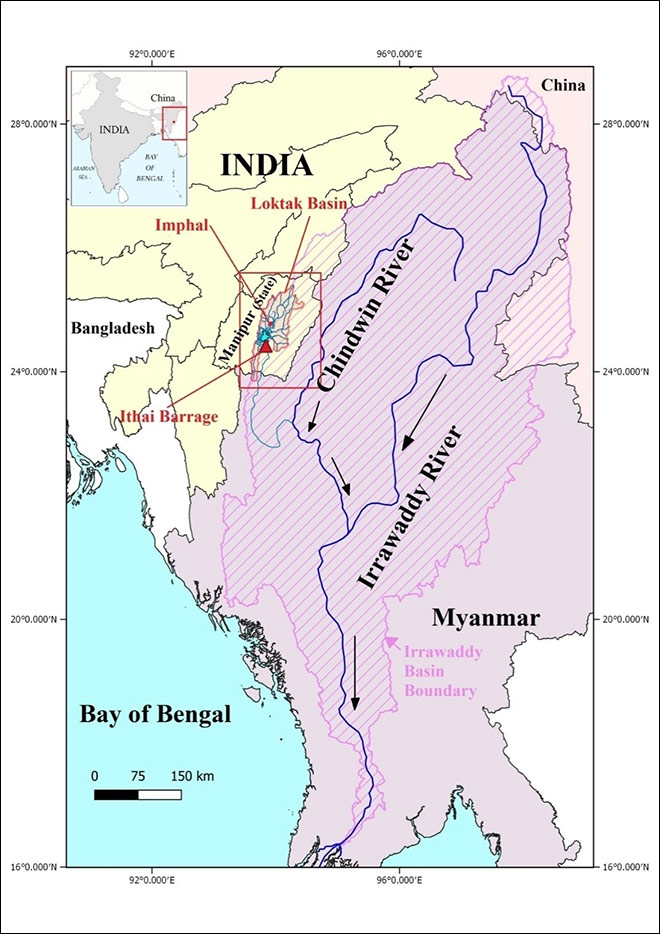
Figure 1: Location of the Loktak Basin and the Ithai Barrage
The Loktak Lake is situated in such a basin. In 2002, about 385 square kilometres of the Loktak basin was found to be covered by pats,[14] the largest and the most important of which is the Loktak Lake. The lake has an area of 287 square km.[15]It absorbs floodwater during the monsoon, and its water is used for agriculture during dry seasons. It provides valuable ecosystem services to the region, such as water, food, fodder, fuel, timber and other wetland products, as well as supporting many species of flora and fauna. It also has great cultural value—the Loktak Lake is considered a mother goddess in Manipur.[16]
The oval-shaped lake is 26-km long and 13-km wide, with an average depth of 2.7 metres. The southern part of the lake has 14 hills of varied sizes and elevations that look like islands, the most prominent being the Sendra, Ithing and Thanga.[17]
Drainage
Loktak Lake has a centripetal drainage system. All the major channels in the basin drain into the lake. The Loktak basin is a sub-basin of the Manipur River basin, with a direct catchment area of 980 square km and an indirect catchment of 7157 square km.[18] The lake drains through the Manipur River, a trans-boundary water body between India and Myanmar that joins the Chindwin river, a tributary of the Irrawaddy. The Loktak basin and the Manipur basin are thus part of the larger Irrawaddy basin.[19]
Of the lake’s 980-square-km direct catchment area, 430 square km are under paddy cultivation, 400 square km are under forest cover, and 150 square km are inhabited. The elevation varies from 780 m at the foothills adjoining the central valley to about 2068 metres above mean sea level.[20]
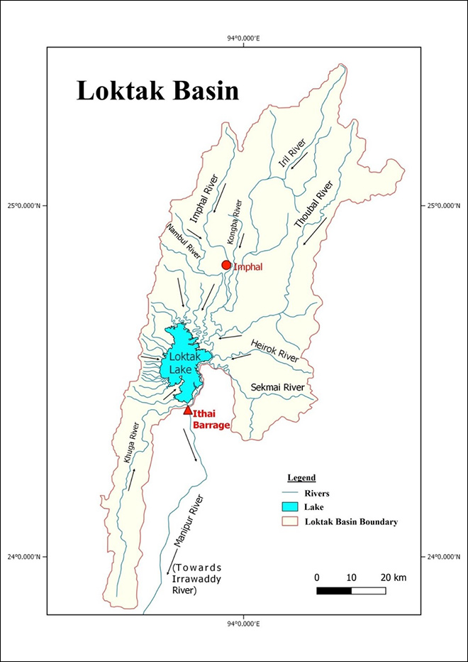
Loktak Lake is primarily fed by eight main rivers—the Imphal, Iril, Thoubal, Kongba, Heirok, Sekmai, Nambul and Khuga. Many smaller rivers and rivulets from the Western sub-catchment also drain into the lake (see Figure 2).
However, in the last two decades, the Heirok and Sekmai rivers have been isolated from the lake through engineering interventions and diversions implemented by the state government. The rivers and rivulets from the Western sub-catchment flow directly into Loktak, while the Imphal, Kongba, Iril, Thoubal and Khuga join the Manipur River.
Figure 2: Drainage of the Loktak Basin with the Ithai Barrage
Source: Author’s own, based on Chabungbam Rajagopal Singh, Hydrological and Hydraulic Modelling for The Restoration and Management of Loktak Lake, Northeast India: PhD Thesis, University College of London (2010) and Google Earth
Precipitation
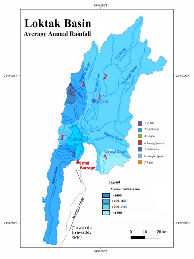
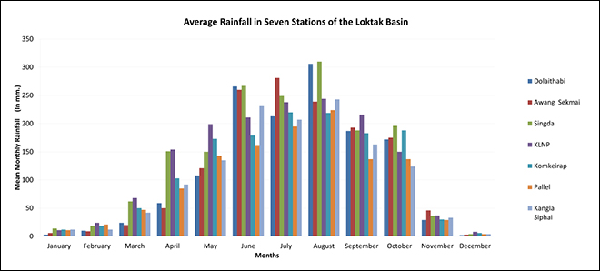
Rainfall in the basin follows the usual South Asian monsoon patterns. The monsoon season begins around mid-May, with the area receiving its highest rainfall in August and lowest in December (see Figure 3b). The November to April period is mostly dry. Before the Ithai Barrage was constructed, the variation in rainfall was reflected in the natural rise and fall of the lake surface.
Figure 3a: Average Annual Rainfall in the Loktak Basin
Source: Author’s own, based on Chabungbam Rajagopal Singh, Hydrological And Hydraulic Modelling For The Restoration And Management Of Loktak Lake, Northeast India: PhD Thesis, University College of London (2010)[21]
Figure 3b: Average Annual Rainfall (Monthly) in the Loktak Basin
Source: Author’s own, based on Chabungbam Rajagopal Singh, Hydrological And Hydraulic Modelling For The Restoration And Management Of Loktak Lake, Northeast India: PhD Thesis, University College of London (2010)[22]
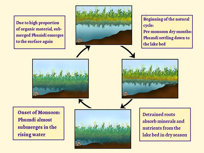
The phumdis
A unique feature of the Loktak Lake is the floating islands made up of heterogeneous masses of soil, vegetation and organic matter (in various stages of decomposition), locally known as phumdis. They vary in size and thickness and occupy about two-thirds of the lake. The southern portion of Loktak Lake has a continuous phumdi that forms the Keibul Lamjao National Park (KLNP), which occupies an area of about 40 square km.[23]
The locals have depended on the phumdis for generations for a variety of bio-resources, such as wild edibles, medicine, fodder, fuel and raw material for handicrafts. A 2013 study of the phumdis identified 27 edible species that are part of the local communities’ traditional food preparations.[24] The staple diet of the people living in the region is indigenous sticky rice, which is accompanied by a vegetable prepared from phumdi vegetation. The women in the area play the leading role in the collection of wild edibles from the phumdis.[25]
Figure 4: The Phumdi Cycle and Grounding of Phumdis
Source: Created by the author from [1]Manisha Singh and Neelam Khare, “Distribution, status and conservation of Sangai deer (Rucervus eldii eldii) in Manipur, India” (2018)[26]
Ithai Barrage and Impact on Loktak Hydrology
The Loktak Hydroelectricity Project was conceived as a multipurpose project to supply electricity to various parts of Manipur and the neighbouring states, and included a lift irrigation facility. Loktak Lake formed the headwater for the project.[27]
The Ithai barrage has a total length of 68.6 metres, with a full reservoir level (highest level at which water can be stored safely without compromising structural safety) of 769.63 metres above sea level and a flood level (beyond which the peripheral area of the lake will flood) of 768.50 metres above sea level.[28] The minimum drawdown level to abstract water from the lake for hydropower generation is fixed at 766.23 metres above sea level.[29]
A barrage was created on the Manipur river, near the village of Ithai, to maintain the water level required for the continuous generation of hydropower.[30]Although the Ithai Barrage served immediate purposes, it had significant impacts on the hydrology of the lake and affected the ecology and socioeconomic structure of the region.
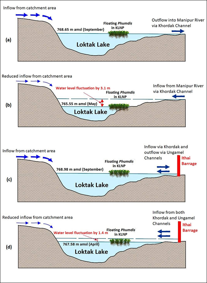
The Loktak Lake is linked to the Manipur river mainly through the Khordak channel.[31] Khordak is a bi-directional channel—during the dry season, when the lake water level is lower than the channel’s, Khordak supplies water to the Loktak. During the monsoon, when Loktak’s water level rises higher than that of the Khordak channel, Khordak carries water from the lake (see Figure 5a and 5b).
After the construction of the Ithai barrage, when the outflow of the lake during the dry season was controlled, the lake’s hydrology was drastically modified. The influence of the Manipur River on the lake increased. A new channel, Ungamen, was used to divert the backflow from the barrage into the lake. The restriction and modification of the flow has resulted in an almost stagnant body of water until the barrage. While the fluctuation of water level in the lake before the barrage’s construction was around 3.1 metres, the post-barrage level fluctuations have reduced to about 1.4 metres (Figures 5c and 5d).
The obstruction of the lake’s natural flow continues till date. The barrage has provided electricity for the last 37 years but has also created complications in the region, including the siltation of the lakebed.
Flooding of the peripheral area
A study noted that for 46 percent of its four-year duration, the water level of the Loktak Lake was maintained above the flood level, causing flooding in the peripheral areas, including agricultural and residential lands.[32] Such flooding began in 1983, the year the barrage was constructed, causing displacement and loss of economic activity in the surrounding areas. After being displaced to make way for the dam, many locals were forced to create permanent residence on the phumdis, which were mostly seasonal before the prolonged floodings.[33]
Figure 5: Schematic Diagram of Changes in Hydrological Regime of Loktak Lake After the Construction of Ithai Barrage.
(a) Pre-Ithai Barrage high water level – September (b) Pre-Ithai Barrage low water level – May (c) Post-Ithai Barrage high water level – September (d) Post-Ithai Barrage low water level – April.
Source: Created by the author from Chabungbam Rajagopal Singh, Hydrological And Hydraulic Modelling For The Restoration And Management Of Loktak Lake, Northeast India: PhD Thesis, University College of London, 2010[34]
Obstruction of traditional fishing
The construction of the Ithai Barrage has impacted the natural hydrological regime and obstructed the migratory routes of fish through the Manipur River. As a result, there has been a substantial decline in the population of riverine fish like Pengba, Khabak, and Shareng.[35]
Ataphum and phumdiproliferation
The people living around the lake were dependent on it for fishing. With the loss of their residential and agricultural lands and a decline in the fish population, they have become more dependent on the ataphums (floating fishing ponds). Traditionally, ataphum fishing was a monsoon activity. But with the construction of the Ithai Barrage and the continuous high water level, ataphum is now carried out through the year, resulting in a proliferation of ataphum and phumdis.
However, the presence of many ataphums obstructs the movement and circulation of the water and sediments in the lake.[36] An estimated 25 percent of the lake’s water-holding capacity has been lost due to the annual deposit of 336,325 tonnes of silt.[37] The enhanced sedimentation is partially due to the obstructed flow pattern inside the lake caused by the proliferation of phumdisand ataphums. The lake’s navigational benefits have also decreased due to the ataphum’s interference.[38]
Some fisherfolks have started using non-traditional practices—such as using insecticides—that have had an extremely detrimental impact on the water quality and aquatic biodiversity. Such hazardous chemicals not only poison but also increase the nitrogen levels in the water, leading to an unhealthy burst of the phumdis.[39]
The phumdis and other suspended vegetation eventually meet effluents brought to the lake by the Imphal River from Imphal’s sewages. This causes a horizontal proliferation of surface vegetation over the lake, obstructing sunlight and causing harmful vegetation blooms that could choke the lake.
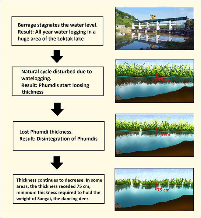
Decrease in phumdithickness
The obstruction of the Loktak Lake’s hydrological regime and maintaining the water at a specific level has also impacted the phumdis’ natural cycle and threatens the Keibul Lamjao National Park. After the construction of the Ithai Barrage, the minimum monthly mean water level increased from 765.55 metres above sea level to 767.58 metres above sea level. The dry season is when the phumdis ground and acquire new soil and nutrients. But with an increase in the water level, the phumdis remain afloat throughout the year and cannot ground, depriving them of the nutrients they uptake from the lakebed in the dry season (see Figure 6). This has been attributed as one of the leading causes for the degradation of phumdis in the Loktak Lake.[40] The situation is most alarming for the Keibul Lamjao National Park, where the thinning of the phumdi threatens the survival of the rare Sangai deer (see Figure 6).
Figure 6: Schematic Diagram of Phumdi Thinning after The Construction of Ithai Barrage.
Source: Created by the author from Singh and Khare, 2018.[41]Image of the barrage taken from NHPC.
Conflict between Authorities and Locals
Given the threat from the growing number of ataphums and phumdis and the increasing number of permanent phumdi dwellers, the Loktak Development Authority recommended all phumdis be cleared. This led to a clash between the authorities and locals who had lost their lands to prolonged flooding and their fish to the river obstruction, and were now dependent on the phumdis and ataphums for their livelihood. In 2011, the authorities cleared over 700 phumdihuts, forcing many people to relocate.[42]
However, the situation has since improved and the authorities have appeared willing to work with the locals in recent years. No situation of eviction has taken place after that. Some residents have come back. The state government, as mentioned earlier, is taking the demand of decommissioning seriously.
The LDA is constantly trying to include more and more local residents in its activities for saving the lake. The LDA is working to promote sustainable resource development and livelihood improvement programs in the local area including sustainable fisheries development, management and utilisation of aquatic vegetation and also development of eco-tourism via community and stakeholder participation.[43]
The Dangers of Decommissioning
The Ithai Barrage has caused ecological problems that have led to socio-political issues. To resolve this conflict, the removal of the barrage seems justified. But some experts have raised concerns over such a proposal.
There is no doubt that the Loktak ecosystem has transformed since the dam was commissioned in 1983. Decommissioning the dam now would mean undoing 37 years of ecological adaptations and forcing a radically new condition upon the ecosystem. This will be stressful for the human, plant and animal life that has gradually adjusted and adapted to the ecological changes forced by the construction of the dam.
As the existence of the Ithai Barrage already influences the morphological character of the lake, the removal of the structure will have long-lasting effects. A substantial amount of sediment accumulation has already happened over the last 37 years, resulting in a water-holding capacity loss of about 25 percent, as of 2005.[44] This figure is only likely to have grown since then. The drying of local wetlands is not uncommon in the region.In 2018, the State Wetlands Authority recorded the disappearance of 200 local wetlands, including the Lamphel Pat, Porom Pat, Sangai Pat, Takyel Pat and Akam Pat.[45] Given the volume of siltation accentuated by the dam since its construction, the Loktak Lake may also face such a threat if the barrage is decommissioned.
The Loktak basin has seen a rapid increase in population and intensive land-use over the last decade. Those against the decommissioning of the barrage maintain that such action will lead to the shrinking of the wetland in dry season and open a large part of the area to encroachment. There is also the threat of horizontal proliferation of phumdis and the lake being choked due to increasing pollution.
The Loktak wetland had an extended portion towards the eastern part of the Imphal River, outside the notified lake boundary, as of March 2011.[46] But in 2020, there are just a few ponds in their place, and this area can hardly be identified as an extension of Loktak. The region is now scattered with new settlements and agricultural fields. If the barrage is eventually decommissioned, this will be an issue, and the Loktak Development Authority will have to keep the encroachment at bay to restore and preserve the lake’s unique environment.
Conclusion
Hydropower projects in Himalayan basins are extremely challenging endeavours and should require a detailed in-depth assessment of their impact before any construction begins. When created on unique ecosystems like mountain lakes, the need for a thorough evaluation of such projects becomes even more severe. Several hydropower projects in India have faced controversies for starting construction without accurately assessing the possible implications.[47] Before obstructing the flow of a lake, as has happened with the Loktak Lake, all potential impacts and outcomes must be evaluated and addressed. Similarly, any decommissioning should be scientifically planned and not just follow populist sentiments.
India does not have a history of systematic dam decommissioning owing to ecological concerns. Some dams were reconstructed due to their fragility, with new structures created in their place. For instance, the colonial Tajiwala barrage on the Yamuna river was decommissioned in 1999[48] and replaced by the Hathikund dam in 2002.
To move towards a safe and sustainable future, India may need to reconsider some structural constructions, especially if the structure harms the ecology and economy of the region. While decommissioning the Ithai Barrage and returning to a pre-dam state might seem lucrative and righteous, this may not be entirely possible given that the structure has been standing for 37 years and has undoubtedly caused significant changes in the local hydro-geomorphology. If India does decide to decommission the Ithai Barrage, the decision must be grounded in unbiased scientific research on the possible impacts.
India must also learn from this experience and conduct proper pre-project environmental impact assessments for other proposed engineering interventions.
On 7 August 2019, the division bench of the Manipur High Court passed an order prohibiting any new project or development programmes on Loktak Lake without the court’s permission.[49] Any new development regarding the proposed decommissioning of Ithai Barrage is yet to arrive. The decision is now up to the authorities. However, if scientifically addressed, the issue of decommissioning the Ithai Barrage can be an example for lake-based hydropower projects in the Himalayas and elsewhere.
[4] A Ramsar site is a wetland site designated to be of international importance under the Convention on Wetlands, also known as the Ramsar Convention. The Convention on Wetlands is the oldest of the modern global intergovernmental environmental agreements. The treaty was negotiated through the 1960s by countries and non – governmental organizations concerned about the increasing loss and degradation of wetland habitat for migratory water birds. It was adopted in the Iranian city of Ramsar in 1971 and came into force in 1975, thus the name. The wetlands identified as a Ramsar site usually extreme ecological and socio-economic influence on the regional, national and international level.
[5] S. Maudgal, “Assessment of Existing Operating Regime for Water Management”, Consultancy Report. Sustainable Development and Water Resource Management of Loktak Lake. 2000.
[6]PWD, “Loktak Lake Multi-Purpose Project: Part 1 – Power”, Public Works Department, State Government of Manipur, Imphal, India. 1967
[7]Chabungbam Rajagopal Singh, “Hydrological and Hydraulic Modelling for The Restoration and Management of Loktak Lake, Northeast India” (PhD Thesis, University College of London, 2010)
[11] C.L.Trisal, Th. Manihar, Robson Ivan and Romi Singh (Ed.), Loktak News Letter , Volume-1, (Loktak Development Authority & Wetlands International – South Asia, 1999)
[12] Singh, “Hydrological And Hydraulic Modelling”
[14] C. L. Trisal and Th. Manihar, The Atlas of Loktak Lake (Loktak Development Authority, Manipur, India and Wetlands International – South Asia, New Delhi, India. 2004)
[24] M. D. Meitei & M. N. V. Prasad, “Phoomdi – a unique plant biosystem of Loktak lake, Manipur, North-East India: Traditional and ecological knowledge”, Biosystems 149, no. 4 (January 2014): 777-787
[26] Manisha Singh and Neelam Khare, “Distribution, status and conservation of Sangai deer (Rucervus eldii eldii) in Manipur, India”, Journal of Entomology and Zoology Studies 6, no. 5: 732-737, 2018
[27] Singh, “Hydrological And Hydraulic Modelling”
[36] C. L. Trisal and Th. Manihar (Eds), Management of Phumdis in Loktak Lake,
(Proceedings of a Workshop on Phumdi Management, Loktak Development Authority, Manipur, India and Wetlands International-South Asia, New Delhi, India, 2002).
[37] WISA, Conservation and management of Loktak Lake and Associated Wetlands
Integrating Manipur River Basin: Detailed Project Report, (Wetlands International-
South Asia, New Delhi, India, 2005)
[38] Singh, “Hydrological And Hydraulic Modelling”
[40] S. S. Singh,“ Vegetation and Phumdi of Keibul Lamjao”, In Management of Phumdis in Loktak Lake, ed. C. L. Trisal and Th. Manihar (Proceedings of a workshop on Phumdi Management, Imphal, Manipur January 2002.WetlandsInternational – South Asia, New Delhi, India and Loktak Development Authority, Manipur, India. 2002), and
Ng. S Meitei, “Loktak Lake Hydrology and Phumdi Management”, In Management of Phumdis in Loktak Lake, ed. C. L. Trisal and Th. Manihar (Proceedings of a workshop on Phumdis Management, Imphal, Manipur January 2002.WetlandsInternational – South Asia, New Delhi, India and Loktak Development Authority, Manipur, India. 2002), and
Angom, “Ecological Studies of Vegetation in Keibul Lamjao National Park, Manipur.” PhD Thesis: School of Sciences. Manipur University, Imphal, India, 2005.
[41] Singh and Khare, “Distribution, status and conservation of Sangai deer”
The views expressed above belong to the author(s). ORF research and analyses now available on Telegram! Click here to access our curated content — blogs, longforms and interviews.
Jaya Thakur was a Junior Fellow at ORF Kolkata. Worked with the Economy and Development Programme at ORF Kolkata. Her specialization is Environmental Issues in ...

 PDF Download