This paper deals with issues pertaining to the implementation of Comprehensive Integrated Border Management System (CIBMS), which was formulated in July 2016 after the attack on the Pathankot Air Force Station in January. It is believed that the attackers came from Pakistan to Punjab by crossing the international border, and this has made the government re-evaluate the existing mechanism of border security. The imperative has become more urgent for an overhaul of the surveillance system along the border, especially in the context of electronic surveillance. The stringency of surveillance also needs to be increased. However, before implementing the project, there are various issues facing border-management practitioners that need to be addressed. The issues need comprehensive analysis on both policy and implementation level, and the project needs to be implemented in a way that can deal with the challenge of not only infiltration but also future issues such as migration, community protection and area development.
Introduction
“To be called a sovereign nation, a nation has to be able to control its own borders. It is controlling your own destiny in a way, and we don’t control our own borders.”—Tom Tancredo
This paper is divided into two sections. The first section gives an overview of India’s western border and the events that necessitated the formulation and adoption of CIBMS. The second section deals with the challenges faced by the executioners of the project. The paper looks into concerns regarding implementation that are expected to emerge in the future. It discusses the various problems and challenges in this project from the perspective of the enforcer, i.e., the Border Security Force (BSF), and the changes that are required to be made structurally and institutionally, in addition to other factors such as border population, crime scenario and availability of land. The study focuses on the Punjab border for discussion and analysis.
Indian borders, like most manmade borders, are political boundaries. The borders dividing India from Bangladesh and Pakistan were marked based on revenue maps and ethnic differences. Such demarcation has created a unique set of problems. India has 14,818 km of land borders and a coastline of 7,516.6 km. All states, except Madhya Pradesh, Chhattisgarh, Jharkhand, Delhi and Haryana, have an international border or a coastline. A big number of India’s districts—92 out of 640, according to the 2011 census—are border districts in 17 states. Indian borders run through plains, hills, mountains, deserts, riverine territories and marshes. Managing such an expansive border is a complex task, but it is vital from the point of view of national security. The problems related to border security include unsettled maritime boundaries, lack of fully demarcated land borders, and borders based on artificial boundaries rather than natural ones.
Border-guarding forces are often short on resources and ill-equipped for modern border management and mastery. Intelligence gathering is imperfect, as are intelligence sharing and intelligence coordination—this situation needs to be changed, especially as, for example, the Indo–Pak border has been categorised as one of the most dangerous in the world. Ever since its bloody creation in 1947, which saw the displacement and killing of millions, the border area between India and Pakistan has been marked by violence. A ceasefire line, known as the Line of Control, remains in effect, with three areas of Kashmir under Indian administration and two under Pakistan. Neither side has ever formally recognised the accession of the areas claimed by the other.[i]This tension has led to three wars, and Pakistan’s support to Punjabi, and later Kashmiri, separatists has made this border prone to infiltration by militants and smugglers, posing grave challenge and risk to forces that guard it.
Despite these challenges, however, it would appear that some progress has been made. Between 2004 and 2007, diplomatic talks established the framework for a settlement over Kashmir, under which Pakistan would in effect give up its claim to Indian Kashmir, and India would agree to a ‘soft’ border (one allowing a lot of freedom of movement).[ii]This raises the important question of whether the government is paying enough attention to the security of this particularly sensitive border.
Due to the proclivity of India’s neighbours to exploit India’s nation-building activities, the country’s internal security challenges are inextricably linked to border management. The issue gets further complicated due to the highly porous and contested border India shares with its western neighbour, Pakistan. The history of mistrust and constant border skirmishes along the line of actual control makes India highly susceptible to cross-border terrorism, which in turn poses a grave threat to the country’s internal security. Despite several such wars and conflicts, Indian borders continue to be guarded by military and police forces that report to different ministries in the Centre, making the border management task arduous and leading to duplication of efforts by the security forces.
The various border security threats are broadly classified under the following categories:
Infiltration and ex-filtration of armed militants
Non-state actors
Narcotics and armed smugglers
Illegal migrations
Separatist movements aided by external powers
Establishment of madrassas, which must be watched for any potential security hazards
Export of fundamentalist terrorism
Smuggling of counterfeit Indian currency
These situations and threats exacerbate the already fragile border equation with India’s western neighbour, leading to highly volatile situations that the security forces are ill-equipped to handle given poor intelligence capabilities and severe resource deficiency.
For over 50 years, India has been engaged in an eyeball-to-eyeball confrontation with daily loss of life and property, which could justifiably be called a “low intensity limited war.” Similarly, India’s border with Myanmar is threatened by several insurgent groups that have found sanctuaries with cooperation from the Myanmar army. Similar political boundary issues of “enclaves and adverse possessions” in Bangladesh have resulted in political sensitivity along the entire western border that India shares with its immediate neighbours. However, on 1 August 2015, under their Land Border Agreement, India and Bangladesh exchanged 162 enclaves, ending one of the world’s oldest border disputes. A total of 111 enclaves from India, measuring 17,160 acres, and 51 enclaves from Bangladesh (17,110 acres), were exchanged.
One important aspect of border security is the stability of neighbouring countries. India’s neighbourhood is constantly in turmoil. Several of India’s neighbours are experiencing political and economic instability. India also has ongoing border disputes with several of its neighbours. Uncertainty in borders not only raises bilateral tensions but also facilitates cross-border infiltration, illegal migration, smuggling and crime. Illegal migration has emerged as one of the major national security challenges. Even at present, border guarding is personnel-intensive, almost fully dependent on human surveillance. The border fence was planned in the 1980s because of Punjab militancy. This mode of border guarding, however, has become outdated, despite periodic revisions to methodology. Understanding the importance of border security, the government formed the Group of Ministers (GOM) to address the issue comprehensively. The GOM performed a thorough review of border management issues in 2001 and made several recommendations.[iii]Many of these recommendations are now being implemented.One of the major recommendations was the setting up of a separate Department of Border Management within the Ministry of Home Affairs (MHA). This has been implemented by the government and a separate department has been created in the MHA. Other significant recommendations, such as the early settlement of Indian maritime borders and the demarcation of land boundaries, have not yet been fully implemented. Nonetheless, the government has done commendable work in settling to a great extent the issue of enclaves with Bangladesh. One of the most important issues was to bring uniformity and cohesiveness in border guarding by assigning the responsibility of border security to a single force. The Indian Government has already pulled out Border Security Force from internal security duties from Jammu and Kashmir and deployed it for security of border—this process was completed in 2008. The GOM had strongly recommended the principle of “one border one force” for better accountability.[iv]It emphasised the significance of not deploying the border-guarding forces for law-and-order duties and counterinsurgencies. It made some recommendations specific to better management of India–Pakistan, India–Nepal, and other borders. The group also pointed out the neglect of maritime borders and island territories and made recommendations to strengthen the coast guard and police. Following these recommendations, border management has received increased attention, but the Mumbai terrorist attack of November 2008 once again proven that a lot more needs to be done to improve border management in the context of maritime boundaries, even as several thousand crores of rupees have been spent on their modernisation and expansion.
It is clear that managing borders is a time-consuming, complex task. Technology will play a major role in improving border management. The government may also need to derive implementable ideas from systems of border management of other large countries.
I. India–Pakistan Border Scenario
India shares a long and complicated boundary with Pakistan, extending over 3,323 km. The India–Pakistan border is categorised under three different heads. The first is the international boundary also known as the Radcliffe Line. It is 2,308-km long and stretches from Gujarat to parts of the Jammu district in Jammu and Kashmir. The second is the Line of Control (LOC) or the Cease Fire Line, which came into existence after the 1948 and 1971 wars between India and Pakistan. This line is 776-km long and runs along the districts of Jammu (some parts), Rajouri, Poonch, Baramula, Kupwara, Kargil and some portions of Leh. The third is the Actual Ground Position Line (AGPL), which is 110-km long and extends from NJ 9842 to Indira Col in the North. The LOC and the AGPL have been the scene of constant tension with border skirmishes and firing between the armies and border-guarding forces of both countries. Like the Bangladesh boundary, the India–Pakistan boundary, too, does not follow any geographical barrier. It runs through diverse terrain including deserts, marshes, plains, snow-clad mountains, and winds its way through villages, houses and agricultural lands. This makes the border extremely porous. Porosity of this border has facilitated various illegal activities such as smuggling, drugs and arms trafficking, and infiltration. Heroin and fake Indian currency are the two predominant items smuggled along this border. Other items include saffron, textile and mercury, which are smuggled from Pakistan. The villagers adjacent to the border are alleged to be involved in smuggling in a big way. Money laundering is also quite rampant along the border. A large-scale money laundering network is flourishing in Punjab, especially in Ludhiana.[v]In addition, the border population has also been subjected to hostile propaganda by Pakistan, designed to mislead and sway their loyalties. The Sir Creek area, due to its peculiar terrain, makes the movement of border-guarding forces very difficult and thus, provides scope for illegal fishing in the creeks.
Kargil: Lesson Learnt
Although the Indian government had been formulating various schemes for managing these diverse challenges, the concept of ‘border management’ entered the government lexicon only in the wake of the Kargil conflict of 1999 and the subsequent report submitted by the Kargil Review Committee. Based on the recommendations of the Review Committee, in April 2001, the Government of India set up the Task Force on Border Management, under the Chairmanship of Madhav Godbole. The Task Force’s objective was to “consider measures for border management and, in particular, to consider the recommendations of the Kargil Review Committee in this regard and formulate specific proposals for the GOM’s consideration.”[vi]The Report of the Task Force, which was presented in 2001, is the first comprehensive document on border management, and it provided various suggestions for improving border management and security. The report observed that the country’s borders could not be effectively managed because of certain inherent problems such as their disputed status, artificiality and porosity, which, according to the report, give rise to multiple other problems including illegal migration, smuggling, drugs trafficking, and trans-border movement of insurgents. The Committee also recommended that the government resolve pending border disputes with the neighbouring countries, as they later become matters of national-security threat. One example of such unresolved matters is India’s long standing issue in Sir Creek, the dispute being on the interpretation of United Nations Convention on the Laws of the Sea, wherein both the countries have their own contradicting interpretations. The dispute covers the whole of Sir Creek area right from the mouth of the Creek in the Arabian Sea to the end of it in east. To enforce accountability, the Report recommended that the border-guarding force should not be distracted from its principal task and deployed for other internal security duties. It also recommended the establishment of a marine police force, the strengthening of the Indian Coast Guard and setting up of an apex institution for coordinating various maritime issues.[vii]The Report recommended accelerated development of infrastructure along the border, especially to wean the border population from illegal activities. After this report, the government made concerted efforts to create comprehensive security infrastructure at the border, especially in the eastern sector. The approach as employed by the government towards managing the borders has four important elements, viz., guarding, regulation, development of border areas, and constituting bilateral institutional mechanisms for resolving disputes and ironing out conflicts with neighbours.
Significant Incidents
Recently, there have been two major incidents of terrorist attacks within one year, which has once again exposed the vulnerability of India’s borders and other issues related to security. On 2 January 2016, a heavily armed group attacked the Pathankot Air Force Station, part of the Western Air Command of the Indian Air Force. Four attackers and two security force personnel were killed in the initial battle, with an additional security force member dying from injuries hours later. The gun battle and the subsequent combing operation lasted for about 17 hours on 2 January, resulting in the death of five attackers and three security personnel. The attackers, who were wearing Indian Army fatigues, were suspected to belong to Jaish-e-Mohammed.[viii]
On 27 July 2015, three gunmen dressed in army uniforms opened fire on a bus and then attacked the Dina Nagar police station in the Gurdaspur district of Punjab. The attack resulted in the death of three civilians and four policemen, including a Superintendent of police; 15 others were also injured. In addition, five bombs were found planted on the Amritsar–Pathankot line on a rail bridge near Parmanand railway station, 5km away from the site of the attack.[ix]All three attackers were killed in the operation, which lasted for almost 12 hours.
These were the two major incidents. In both cases, it has been suspected that the terrorists must have crossed the border using river gaps and carried out the attack in the wee hours of the morning. A thorough analysis was done about the shortcomings in border guarding, and the analysing team realised that unfenced gaps needed to be augmented by surveillance equipment and with some kind of barrier or obstacle, in addition to increasing the rigour of surveillance.
Special Surveillance Equipment: Present Status
The government has recognised the need for deployment of a suitable mix and class of various types of high-technology electronic surveillance equipment, such as Night Vision Devices (NVDs), Hand-Held Thermal Imagers (HHTIs), Battle Field Surveillance Radars (BFSRs), Direction Finders, Unattended Ground Sensors and High Powered Telescope, on the International Borders of the country, to act as a force multiplier for effective border management. The procurement process was started in 2006–2007. Various equipment such as HHTIs, BFSRs, Long Range Reconnaissance and Observation System and Passive Night Vision Binoculars (PNVBs) have been procured and deployed on the Indo–Pakistan, Indo–Bangladesh, Indo–China and Indo–Myanmar borders. In 2009–2010, there was a proposal to procure additional HHTIs, PNVBs and Mobile Surveillance Vehicles.
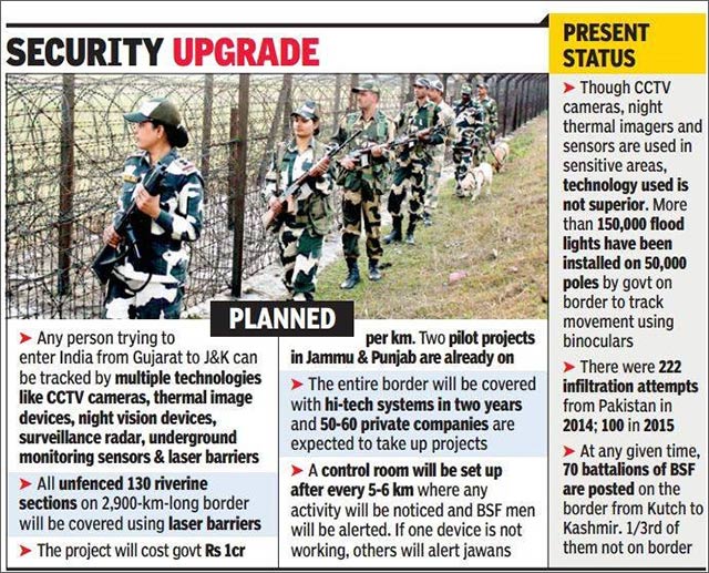
In January 2016, the Centre approved a five-layer elaborate plan to stop infiltration on the 2,900-km western border with Pakistan. Close Circuit Television cameras, thermal imagers and NVDs, BFSRs, underground monitoring sensors, and laser barriers will be placed along the border to track all movement from the other side. The integrated setup will ensure that in the event of a transgression, if one device fails to work, another will alert the control room. Laser barriers will cover 130 unfenced sections, including riverine and mountain terrain from Jammu and Kashmir to Gujarat, which are often used by infiltrators.
II. CIBMS: Concept and Technical Issues
The concept of CIBMS has long been in consideration for effective border security, but it was in 2015 that the government started to implement an initial version of it. The MHA is currently identifying the technology that can be applied along the country’s land borders based on the various types of terrains that exist. The plan entails installing equipment in a manner that they do not get affected by natural calamities, such as flash floods. In the wake of the recent terror attacks in Dina Nagar of Punjab (July 2015), Udhampur (August 2015) and in Pathankot (January 2016), better border guarding using high technology has become an imperative.[x]Explaining the functioning of the CIBMS, sources called it “an integration of humans and technology with the Command and Control centre at the heart of it.”
An important component of the CIBMS is the use of satellite imagery, which helps security forces to find out details of the terrain and fortifications across the border. It also helps in planning operations and in infrastructure development. India’s BSF is a regular user of satellite imagery. “The Prime Minister has directed that such technology must be shared with security forces, because of which officials of the Indian Space Research Organisation (ISRO) have been coming to us, and we are receiving the latest satellite imagery of the areas we guard. Earlier, the process of receiving satellite imagery was slow because of its confidentiality.”[xi]The BSF has installed a 3-D based Geographic Information System, which captures, stores and displays data related to locations on the Earth’s surface. Satellite images procured by the BSF from ISRO and National Technical Research Organisation (NTRO) are installed in the system, enabling the BSF’s headquarters and ground units to view them. The feasibility of using drones, Unmanned Aerial Vehicles (UAV) and Aerostat Balloons fitted with day- and night-vision devices may also be used. It is important to mention that India could learn from the Israeli experience of the use of UAVs and drones, specifically at the Gaza border. Possibilities may also be explored for greater cooperation and transfer of technology for obtaining real-time images via Geospatial imaging used by the United States.
CIBMS may yet be the best solution to avoid further terror attacks—like the one in Pathankot—as well as infiltration and smuggling. Interestingly, it is also the first time since Independence that India will completely lock its western border, including the riverine gaps. CIBMS will also help security forces catch those who help in infiltration from the Indian side of the border, as the radars will have 360-degree coverage, and the cameras will work round the clock, maintaining surveillance on both sides. The plan to cover existing gaps with a laser wall is in its experimental stage and has been deployed at selected places along the Punjab and Jammu borders. Its results are being recorded, and complete implementation and deployment of the laser wall technology is likely to take some more time. The Ministry of Home Affairs reports that work on two pilot projects on stretches of Punjab and Jammu were started after issuing a global tender. The government has approved 30 km each for installation of CIBMS in Gujarat and Punjab. Plans to cover the entire border with “technological surveillance” in two years are also underway.[xii]
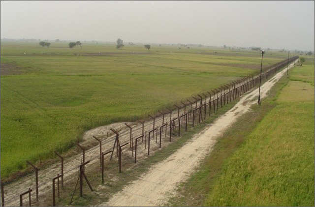
Figure 1:Model of Punjab Border Fence
Source:globalsecurity.org
Figure 2:The clip covers a broad outline of the surveillance plan to check infiltration and smuggling. The cost of such infrastructure is yet to be calculated.
Before starting any project of this nature, a thorough homework is required on the issue of land acquisition, since whatever infrastructure is to be created will require land. There have been cases where the border observation posts (BOPs) were located on land that did not belong to the BSF, resulting in eviction from property; many such cases aresub judicein courts of law. Due to the non-permanent nature of the infrastructure, the BSF has not been able to get even basic facilities such as electricity and water connections. Another unresolved issue is the land acquisition for approach roads; this issue requires permanent solution.
It has been observed that the state of acquisition of land in Central Armed Police Forces (CAPFs) is not satisfactory. An audit of the land acquisition found that neither the MHA nor the CAPFs has any effective land acquisition monitoring system, resulting in delay in acquisition/non-acquisition of land, even after the deposit of land cost with the state government. Further, there is an absence of any structured interaction between higher authorities of CAPFs/the MHA and state revenue departments for sorting out issues causing delay in acquisition of land. Audit examination found that there were abnormal delays in 66 percent of land acquisition cases, in the worst case upto nine years. Moreover, there were instances of violation of the MHA guidelines and norms during land acquisition, inadequate survey before initiating the proposal, among other issues.[xiii]
Land Ahead of Border Fence
One of the trickiest issues of land acquisition is related to the land ahead of fencing. First, the land requires to be thoroughly verified to determine ownership. In Punjab, the situation of land acquisition is appalling, and this has led to the antipathy of local population. People have to resort to long legal processes to obtain compensation for the land ahead of fencing. For instance, around 24,000 acres of land belonging to roughly 6,000 families in 212 villages of Amritsar, Gurdaspur, Ferozepur, Tarn Taran, Pathankot and Fazilka districts have been in dispute since 1988 when the land was undertaken for erecting the fence along the Indo–Pak border.[xiv]
If a piece of land belongs to any government department, such as the forest department, then it can be utilised for installation of solar panels to produce electricity, so that the land can both be utilised constructively and maintained regularly. A welcome step that the government is taking is to shift fences nearer to the border so that the alignment of the fence can be kept straight and minimum land is left ahead of fence.
Multi-tier Line of Interception
Currently, the BSF guards the border in linear deployment, and it is not easy to beat the deployment. However, in case someone passes through it, intercepting the infiltrator is difficult. For these vulnerable areas, there should be two or three layers of security, and the BSF can be assisted by the local police. Since observation needs quick reaction to be useful, sufficient manpower and the locations at which they will be deployed are important factors, and in conjunction with multilayer observation and detection systems, it is possible to formulate an effective reaction system. Overhauling of the intelligence system is also necessary, since a proactive information system is required, and this can be achieved by coordinating with the local police and other agencies.
Riverine Terrain
Under CIBMS, more than 40 vulnerable unfenced stretches along the India–Pakistan border will be covered by laser walls, with the Home Ministry making it a top priority to check infiltration of terrorists. For riverine gaps, laser walls will be used so that these gaps can be effectively plugged and kept under constant surveillance under all-weather conditions. A laser wall is a mechanism to detect objects crossing the line of sight between the laser source and the detector. As of now, only five to six out of around 40 vulnerable points are covered by laser walls. This laser beam over the river sets off a loud siren in case of a breach whenever any object crosses through the area covered by laser beam. The new system, comprising thermal imaging, fibre optics communication, radars scanner and sensors, will be installed at the eight rivulets along the International Boundary. According to the MHA, there is roughly 145.876 km of unfenced riverside stretch, which is about 6.3 percent of the total Indo–Pak border.[xv]
As far as deployment of laser wall is concerned, the Flood Department of the state is to be made stakeholder, since it is important to build an embankment to stop the course-changing tendency of rivers and to narrow down the main channel of flow. The laser beam infrastructure can be installed on these concrete embankments so that during flood, there is no threat to the instruments. Before installation, the systems have to be tested in all climatic conditions, such as heavy rain, storm and dense fog, since most of these equipment functions on ‘line of sight’ principle and are affected by these factors.
It is extremely important to ensure that the laser walls can be extended whenever an area needs to be secured. Currently, the most common solution is surrounding the area’s perimeter with a fence. However, many cases require the secure area to be extended beyond the confines of the fence, i.e., to create an external perimeter so that the approach of an intruder is detected well before the inner area is reached.
BSF: Border Population Interface
The condition of border population is evident in the two incidents cited in the paper. Often, people feel trapped between the border forces of the two countries and other agencies. Living near the border is like being perched on a livewire. The entire border belt from Fazilka up to Gurdaspur is an example of how things have become increasingly difficult for villagers over the years. There are no jobs, no proper healthcare services, and crops in large tracts have been damaged by waterlogging. In addition to this, the security situation has been tense ever since the Pathankot and Dina Nagar terror attacks.[xvi]Therefore, once CIBMS is implemented, it is important to study the project’s impact on the most important stakeholders, i.e., the border population.
The first major issue of concern is that with the expansion of area of surveillance, the local population should not feel that the infrastructure is violating their privacy or hampering their normal life. The second issue, pertaining to land acquisition, is that while setting up security infrastructure, some legal issues and litigations are bound to arise. To minimise them, prompt and appropriate compensations are to be awarded, so that dissatisfaction among the people for whom this project is to be launched is alleviated quickly.
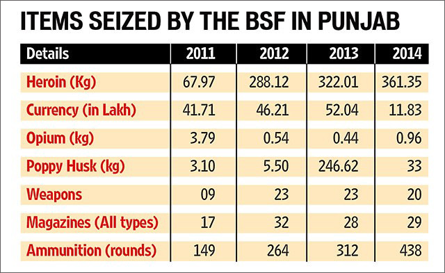
Also important is to study the pattern of illegal activities happening in particular areas such as Punjab, prone to smuggling of narcotics, which makes the state vulnerable to other forms of crime and terror-related activities. Smuggling by residents of border villages is suspected despite fencing and regular patrolling. Considering the continued widespread opium cultivation in Afghanistan, the trafficking of heroin across this border is not likely to abate. Attari, Amritsar and its adjoining areas, Hoshiarpur and Jammu and Kashmir are particularly vulnerable in this regard. Large-scale money laundering operations are being run in Ludhiana, New Delhi, Jalandhar and Amritsar.[xvii]Gainfully employing youth will also check the drug menace and reduce its domestic consumption. The magnitude of this problem can easily be gauged by the information given in Figure 3, and this domestic consumption is mainly responsible for smuggling and other illegal activities. Figure 4 shows a steady increase in seizure of narcotics, which indicates that smuggling, is increasing in border areas.
Figure 3
Figure 4
Source:www.hindustantimes.com
Lack of Critical Infrastructure
Critical infrastructure refers to observation towers, bunkers, Border Flood Lights, and BOPs, among others. There is a need to standardise the design and structure of this kind of defence infrastructure, since the BSF personnel are guarding the border in places where even basic infrastructure is not available. Moreover, when hi-tech equipment will be deployed with the BSF personnel, such standard infrastructure will be commendatory. Deploying special instruments also requires land, which means having to address the issue of land assessment and acquisition so that sustainable solution can be provided for the security infrastructure.
Optimal Utilisation of Existing Technology
In implementing this contract of CIBMS, effective contract management is highly important. Contract monitoring cells can be set up at frontier level, utilising the already available technical staff so that they can overview the implementation of contract. Service backup should be maintained and regular upgrades should be ensured once instruments have been installed. These monitoring cells can report to the Force Headquarters, which in turn can send periodic reports to the ministry concerned.
In addition to this, another major issue to consider is the optimum utilisation of existing equipment and how best they can be utilised in conjunction with the new concept, since the present inventory is also very huge. One of the suggested solutions is to upgrade current equipment, and at a local level, studies can be conducted to evaluate how best they can be used to augment the new infrastructure. Technology compatibility tests can also be conducted by the agency executing the new project.
Need of Technical Battalion
One of the main problems associated with equipment is maintenance and service backup. Once this huge technical infrastructure comes up, it will require technical manpower for its maintenance. For effective maintenance of special surveillance equipment, one technical battalion can be raised at Frontier level, out of which a Company strength may be assigned to concerned Sectors Headquarters. This will reduce the turnaround time for major repair of equipment, which can be executed locally and perhaps even at the site itself. This manpower will be responsible for training of the personnel to be deployed on the border. The raising of technical battalion may be based on deputation for a period of five years, which can be extended by three years on the basis of performance.
Border Area Development Program
The Border Area Development Program (BADP) was introduced in 1993–1994 as a Centrally Sponsored Scheme. Initially, the program was implemented in the western Border States, with an emphasis on the development of infrastructure to facilitate the deployment of the BSF. As per the new guidelines, BADP is to be implemented in a phased manner. The first phase is to be implemented in a0–10km range around the border areas. The guidelines say that the state government can start work in the area beyond the designated 10 km only after the completion of all developmental work under the first phase. However, this is difficult to achieve.
Under BADP, nearly 50 percent of the entire fund is spent on infrastructure creation and development. What needs to be addressed is how this fund can be spent in a way that augments and supports the CIBMS infrastructure for a period of five to 10 years. The projects in relation to CIBMS may be given more emphasis in State Level Screening Committee, and concerned Deputy Inspector General of the BSF, along with commissioners of civil administration in mutual consultation, may submit time-bound plans in this context.
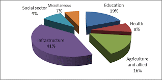
Figure 5:The major part has been spent on infrastructure development, i.e. 41 percent, which can further be developed in the coming years for security and surveillance purposes.
Source:MHA website
Procurement Procedure: Need for Revision
The procurement procedure is based on a tender system at global and national levels. At times, the Request for Proposal lacks technical expertise, and sometimes, feedback is taken from field formations. The border terrain and weather condition in India is largely diverse and different types of equipment requirement may be appreciated, albeit the scenario-based procurement standards can be adopted (as per the requirement of local geographical conditions). Field trials, done in all kinds of weather and scenarios, may be taken into consideration for different specifications of equipment procurement. Different climatic conditions require different levels and methods of maintenance, and service backup is to be included in the contract management system for diverse scenes of employment and deployment.
Conclusion
Although it is the defence forces of the country that are ultimately responsible for defending India’s borders in case of conflict, there are also various peacetime duties, mostly related to policing, that are required to be carried out at the borders. To achieve effective policing, in addition to the BSF, the confidence and cooperation of the local population is important. The whole security infrastructure should be people-friendly and cause minimum inconvenience to the local population. It is also important that border-guarding forces receive maximum support and confidence of the border population. The CIBMS is an ambitious project and is being visualised to check incidents of infiltration and smuggling at the border. It will minimise the probability of incidents like the Dina Nagar and Pathankot attacks. Already, such technology-oriented projects are being implemented on the US–Mexico and Israeli borders, and their reported success in checking infiltration is highly encouraging. For successful implementation of CIBMS, it is mandatory to address the basic issues discussed earlier. The government must create a strong basic infrastructure for implementation of various schemes. In addition, the following issues are also key considerations:
To have necessary land for deployment of multi-tier observation system, land acquisition is of paramount importance.
Manpower and their deployment must be effective so that quick reaction can be ensured on this observation system.
Manpower must be trained beforehand and prompt service backup of equipment should be in place.
A vision for the next five to 10 years must be formulated, including ideas on what new challenges might impede border management and equipment adaptability.
Project management is important, and it has to be ensured that the project is executed within a given timeframe.
It is important to upgrade the present inventory of equipment and accessories in conjunction with the new project so that they are also utilised optimally.
A possible solution is to follow the US–Mexico model, where both the countries have jointly developed border areas, making them more stable economically, socially and demographically so that crime in the border areas can be minimised.
Efforts should be made to utilise the knowledge available with private sector in the context of electronic and surveillance equipment and maintenance and updating of data such as biometric details.
With the development of various economic corridors, the BSF will have to evolve from a restrictive to a permissive organisation without compromising on security aspects.
Knowledge exchange and experience sharing with international border-guarding forces, such as Department of Home Land Security and the Schengen system in Western Europe, can also be taken into consideration.
Giving the BSF investigative powers for specific border crimes will help in improving prosecution of border crimes and prevention of crimes therewith.
The model of Department of Home Land Security for economic and social stabilisation and rehabilitation of border population may be adopted on a pilot basis in some border areas.
The development of Information Technology and the pressures of international trade and commerce challenge the concept of physical borders. Many economic corridors are developing across continents, which may force India to redesign its border management mechanism from the existing restrictive mechanism to a more permissive one.
One of the main aspects of national sovereignty is the safety and security of states’ borders. If the borders are safe and stable only then can the country enjoy economic and social prosperity. Border security and stability depend upon a peaceful conflict resolution approach adopted by the nation’s bilateral and multilateral efforts.
References
[i]Philip Walker, “The World’s Most Dangerous Border,”First Post, June 24, 2011.
[ii]Philip Walker, “India and Pakistan: The World Most Dangerous Border,”The Economist, May 19, 2011.
The views expressed above belong to the author(s). ORF research and analyses now available on Telegram! Click here to access our curated content — blogs, longforms and interviews.

 PDF Download