Climate Change and Sea-Level Rise in the BIMSTEC Region: Towards a Suitable Response
Global warming threatens lives and livelihoods across the Bay of Bengal region. With about nine million people living in low-lying coastal areas in these littoral countries, it is important to understand the changes in key climate variables in the region—primary of which is sea-level rise—and examine the states’ response measures. This brief describes the strategies being taken by countries of the Bay of Bengal Initiative for Multi-Sectoral Technical and Economic Cooperation (BIMSTEC) to mitigate the negative consequences of sea-level rise. It argues that retreat from vulnerable coastal locations will be difficult, and suggests that member states plan carefully to install protective measures to deal with coastal hazards and avoid new ‘development’ projects in coastal locations that are already environmentally vulnerable.
Attribution:
Anamitra Anurag Danda, “Climate Change and Sea-Level Rise in the BIMSTEC Region: Towards a Suitable Response,” ORF Issue Brief No. 408, October 2020, Observer Research Foundation.
Introduction
The BIMSTEC (Bay of Bengal Initiative for Multi-Sectoral Technical and Economic Cooperation) region is home to around 1.7 billion people, with a combined gross domestic product (GDP) of USD 2.7 trillion. Through the period 2014-2018, despite global financial upheavals, the BIMSTEC countries maintained an average economic growth of 5.6 percent. The average annual population growth in the region is 0.91 percent.[1]
Climate change today threatens these lives and livelihoods: the Himalayan glaciers are melting in an accelerated pace; there is increased incidence of floods and landslides in the hills and plains; the sea level is rising; and tropical storms in the coastal regions are becoming more intense. Indeed, the BIMSTEC region is prone to a wide range of extreme weather events, including tropical cyclones, thunderstorms, heat waves, floods, and droughts. It is amongst the most disaster-prone regions in the world: it suffers more than 80 percent of the global fatalities associated with tropical cyclones, even as it accounts for only five percent of those storms.[2]
Worldwide, losses from natural catastrophes are on the rise, mainly due to economic growth in at-risk urban areas. The Bay of Bengal littoral states have between 1.9 to 8.1 percent of their urban populations living in low-lying areas where elevation is below five meters. Between 1990 and 2010, the total percentage of population inhabiting extremely vulnerable Low Elevation Coastal Zones (LECZ)[a] was relatively stable in the BIMSTEC region, with the exception of Thailand and Sri Lanka. During that period, the percentage of population in Thailand, both urban and rural in LECZ increased from 11.9 to 13.4 percent; in Sri Lanka, it declined from 5.5 to 4.3 percent. In Myanmar, Bangladesh and India, meanwhile, the rural population in extremely vulnerable LECZs has declined and the population in urban LECZs has increased (See Table 1).[3]
In the entire BIMSTEC region, not only are losses from natural catastrophes rising due to economic growth in urban areas that are categorised as at-risk, but also due to rapid urbanisation in at-risk locations where elevation is as low as one metre or less. So far, weather-related risks remain insurable; however, insurability can be jeopardised particularly in high-exposure urban areas.[4]
Table 1. Extremely Vulnerable Low Elevation Coastal Zone (LECZ) Urban-Rural Population (1990, 2000, 2010) in the Bay of Bengal littoral countries
With about nine million people in extremely vulnerable low lying areas in the Bay of Bengal littoral states, it is important to understand past and projected changes in key climate variables such as warming, sea-level rise, and tropical cyclonic storms. The information on these variables outlined in the following section of this brief, has been culled from an assessment report that describes the physical science basis of regional climate change over the Indian subcontinent and adjoining areas.[6]
In view of the past and anticipated environmental changes and their consequences, particularly of sea-level rise, this brief attempts to answer the following questions: First, what are the in situ response measures to sea-level rise? Second, are these measures capable of ensuring non-diminishing socio-economic wellbeing until the end of this century? And finally, can population withdrawal from certain vulnerable coastal locations be an effective way of adapting to forces of climate change?
Warming and Sea-Level Rise in the Bay of Bengal Region
Globally, the annual mean near-surface air temperature has warmed by around 0.7 °C during the period 1901-2018, and is projected to reach the range of 2.4-4.4 °C by the end of this century across warming scenarios, relative to the average temperature during 1976-2005. Sea surface temperature (SST) in the tropical Indian Ocean has risen by 1 °C on average over 1951-2015, at a higher rate than the global average, and is projected to increase further during the current century under both medium (RCP4.5) and high (RCP8.5) emission scenarios.[b] The rate of warming in the tropical Indian Ocean is the fastest among tropical oceans and accounts for about one-quarter of the increase in global oceanic heat content over the last two decades.[7]
Sea-level rise is closely related to thermal expansion due to rising ocean SST and heat content. The North Indian Ocean (NIO), for example, rose at a rate of 3.3 mm per year during the period 1993-2017, mostly due to thermal expansion of water. Rates of sea-level variations differ across regions. The largest sea-level changes were observed along the northern and eastern coasts of the Bay of Bengal.
The rise in ocean SST and heat content, in turn, is linked to the intensity of tropical cyclones (TC). Scientists project an increase of about 50 percent in the post-monsoonal cyclogenesis by 2041-2060.[8] However, long-term observations (1951-2018) indicate a significant reduction (-0.26 per decade) in annual frequency of TCs in the Bay of Bengal, although between 2000 and 2018, a significant rise (+0.86 per decade) in the frequency of very severe cyclonic storms (VSCS) has been observed in the post-monsoon season (October-December). This means that within the reduced number of storms in the BIMSTEC region, more are of the ‘very severe’ category. With continued global warming, the activity of VSCS over the NIO is projected to further increase during the current century.
About 80 percent of TCs (on annual scale) in the NIO basin occur in the Bay of Bengal and a significant percentage of these evolve into severe cyclonic storms (SCS) or of even higher category. On average, about five to six TCs are generally observed in the Bay of Bengal every year, of which two or three reach severe stages. From 1981 to 2018, on 40 percent of the occasions, the SCSs in the Bay of Bengal transformed into VSCSs. There were 15 extreme category storms in the Bay of Bengal region between 2000 and 2018.
Based on long-period records, more than 60 percent of Bay of Bengal TCs make landfall in various parts of the Indian east coast, 30 percent experience recurvature and make landfall over other littoral states, while 10 percent generally dissipate over the oceanic regions. The long-term trends of cyclonic storm landfalls in the region between 1877 and 2016 show that despite pronounced shifts across time periods, the median location of cyclones has shifted eastward.[9]
Consequences of warming, sea-level rise and tropical cyclonic storms
One of the main consequences of rise in SST is the increase in mean sea level, which puts human settlements in a heightened risk of flooding. This owes to an increase in the intensity and frequency of extreme sea levels (ESL), exacerbated by tropical cyclones (TCs).[10] Coastal areas become threatened when high tides coincide with extreme weather events and drive ESL.[11] Ocean warming affects ESL and intensifies coastal flood risk.[12] Extreme sea-level projections for the Ganga-Brahmaputra-Meghna delta show an increased likelihood of high water events through this century[13] partly due to the delta falling short in sediment that may not allow maintenance of its current elevation relative to sea level.[14]
The scenario in areas with similar elevation and delta/estuary characteristics across the BIMSTEC region is unlikely to be significantly different. Given that the Bay of Bengal already suffers more than 80 percent of the total global fatalities due to tropical cyclones, while only accounting for five percent of these storms,[15] TC frequency in the Bay constantly poses a serious threat to the BIMSTEC region. “During the passage of a single tropical cyclone, the loss and damage inflicted by a few hours’ battering by waves, winds, and surges can undo the gains from many years of accumulative processes.”[16] A significant eastward shift noted in TC genesis locations in the Bay of Bengal region during post-monsoon seasons enhances the vulnerability of the coastal regions of Bangladesh and Myanmar, in particular.
Potential coastal risks in the Bay of Bengal littoral countries include loss of land due to increased erosion, damage to coastal infrastructure, salinisation of freshwater supply, and a heightened vulnerability to flooding. Higher sea levels and receding coastlines escalate the destructive potential of storm surges associated with cyclonic storms. These impacts of sea-level rise are further compounded by land subsidence. Kolkata, Dhaka, Yangon and Bangkok, for example, are subsiding at average rates between ~10 and 32 mm/year.[17],[18], [19]Ground surface in some areas in Bangkok have sunk below the mean sea level, making the installation of flood drainage systems even more difficult and resource-intensive. The cost of pumping out storm and flood water over the floodgates to discharge into the Chao Phraya River, and eventually the sea, has been progressively increasing over time.[20]
The risks posed by climate change can be considerably magnified when a cascade of climate-related hazards overlap or follow one another. A rise in cyclone intensities will likely result in increasing inundation from the accompanying storm surges that turn proximate agricultural lands and lakes saline, and imperil wildlife. Such sequences of events will become increasingly frequent if anthropogenic climate change continues unimpeded.
Response Measures
Responses to Sea Level Rise (SLR) since 2005 (in the aftermath of the massive Indian Ocean tsunami)[c] have been studied from secondary literature from within the region, as well from the immediate neighbourhood including Vietnam and Indonesia (See Table 2). In situ response measures to sea-level rise take various forms and have different approaches. The measures can be in various forms, including passing legislations and regulations; building hard infrastructure like dikes and sea wall, as well as raised houses; implementing early warning systems; and climate risk insurance. All of these mechanisms aim to reduce risk and build resilience for the continued habitability of coastal areas despite sea-level rise.
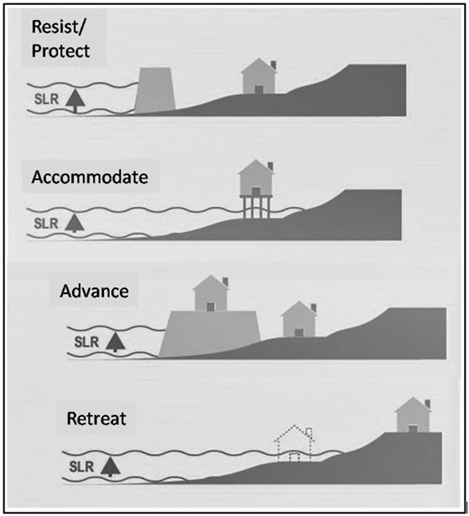
The approaches taken to deal with SLR can be grouped thus: (i) resist or protect; (ii) accommodate; and in certain cases (iii) build seaward (advance) to protect the hinterland (See Figure 1).[21] Often, the implementation of SLR response measures are a combination of approaches and forms, and undertaken only after a coastal disaster has occurred.
In extreme cases, the approach taken is retreat. This was the case in Tamil Nadu in India and Sri Lanka, for instance, after the Indian Ocean tsunami when the governments prohibited rebuilding of habitation along the coastal zone. The state government in Tamil Nadu allocated funds to resettle some 22,000 households that had lived up to 200m from the coast before the tsunami. It is estimated that the entire targeted population of 100,183 was relocated over a period of time. In Sri Lanka, the national government declared a coastal buffer zone 100m wide after the 2004 tsunami. This buffer zone contained approximately 33,000 households. It is estimated that about 91 percent of the targeted population of 126,000 were relocated as part of the retreat initiative.[22] The retreat approach however, is unlikely to be effective for densely populated urban areas since “there are no technological limits to protect the coast during the 21st century even under high-end SLR of 2m.”[23]
Table 2. In situ response measures to sea level rise
Approach
Response type
Country/city/
region
Response measure
Status
Effectiveness
Study
Protect
Hard
Bangladesh
Polders*
Extant
Prevents tidal flooding, salinity intrusion and facilitates the outflow of water. Long-term maintenance of projects remains challenging.
Allowing buildings to float when water level starts to
rise (>0.6m)
Assessment of amphibious building technology
An alternative strategy to mitigate the impacts of flooding to individual buildings and to simultaneously deal with the challenges of restoring and preserving water storage capacity in cities.
Short cycle varieties would allow for continued rice cultivation but salinity will eventually compromise rice production; salinity tolerance limits may be reached before new cultivars are developed.
Renaud et al., 2016
Biophysical
Thanh Phu district, Vietnam
Modification of agro-ecosystems with emphasis on rice-shrimp systems
Extant
Can allow development of livelihoods adapted to both freshwater and brackish water systems, increased resilience.
Conjunctive use of saline and freshwater for maize crop irrigation
Field study
Moderately saline canal water can be used as irrigation water for winter maize. Instead of reducing the number of irrigation events, conjunctive use of freshwater at early sensitive stage combined with saline canal water at a later stage(s) can minimize yield loss of maize.
Builds resilience against hydro-meteorological coastal hazards. Allows people to remain in hazard-prone areas but provide advance warning for evacuation in the face of imminent danger. However, the gap between the logistics and the monitoring of weather data for modelling and fitting of climate systems remains a constraint.
Warning services for the coastal population on tsunamis, storm surges, high waves to Indian Ocean Rim countries. Performance of the warning centre was assessed against a set of indicators and found to be performing as per the design standards.
Index-based climate risk insurance; payments disbursed if index crosses a predetermined strike value; a one percent payment for every centimetre at a hydrological station above a strike value*
Extant
Indexed insurance contributes to breaking the disaster-induced poverty cycle by enabling productive investment. However, the long-term viability of these programs in the face of large, covariant losses is still to be determined.
Potential ex ante risk-management strategy. In case of damage due to flooding, clients receive indemnity payments twice the amount in their savings account thus breaking the “cycle of poverty.” Possibility of “moral hazard,” whereby individuals take fewer precautionary measures because they are insured.
Figure 1. Approaches to response measures to sea-level rise
Source: Adapted from IPCC Special Report on the Ocean and Cryosphere in a Changing Climate, 2019[40]
Long-term efficacy of in situ response measures to sea-level rise
Of the 17 response measures examined by this author, one intervention in Vietnam that undertook adjustment of physical infrastructure for flood mitigation already shows extensive adaptation deficits. Ineffectiveness of the measures has forced households to take on an increasingly active role in addressing current and future hazards. The most widely adopted measures are elevation of household assets, evacuation of children and the infirm, fortification of the housing structure, and repair and recovery after flooding largely independent of any state support. These small-scale adaptation actions are not only limited in efficacy but also are expensive for the affected households. The need for adaptation measures seems to exceed the available adaptive capacities, resulting in extensive adaptation deficits.[41]
Eight of the response measures are unlikely to be able to ensure non-diminishing socio-economic wellbeing during the course of the century (See marked responses in Table 2). Two of these are hard engineering solutions under the ‘protect’ approach. The other eight measures appear to be capable of meeting their objectives through the remainder of the century. These range from building floating houses and promoting vegetable gardens, to modification of agro-ecosystems, and installing early warning systems.
While the measures have been examined in isolation, a combination of approaches and measures, if implemented and operated well, should be able to ensure non-diminishing socio-economic wellbeing for the majority of the nine million people in extremely vulnerable LECZs in the Bay of Bengal littoral countries. This does not take into account the potential storm damage due to intensifying TCs in the Bay of Bengal.
Nevertheless, the Bay littorals and BIMSTEC as a grouping would do well to keep an eye on the top global reinsurance entities like Munich Reinsurance and Swiss Re, particularly their underwriting results, and rates for macro-level insurance for the Bay of Bengal region. A deterioration in underwriting results of top global reinsurance companies over several years not only would jeopardise insurability in high-exposure areas, but can also indicate rising frequency and severity of catastrophic events around the world which has implications not only for the countries and regions that will suffer the direct impacts but also the insured yet unaffected ones. Should rates of insurance across levels become unaffordable or nearly so, it would be time to opt for the ‘retreat’ approach.
Population Withdrawal as Response
‘Retreat’– or moving people and assets out of harm’s way – is already occurring in many coastal areas but typically as an ad hoc measure to reduce risk, and as an individual goal.[42] Institutionally adopting the ‘retreat’ approach will mean that certain areas in LECZs will have to be relinquished pre-emptively to reduce their exposure to the negative consequences of sea-level rise.[43] In a list of 27 instances worldwide where population withdrawal has been implemented (not all involving coastal zones), in about 56 percent of these cases, population withdrawal has been completed. (The authors of the study, however, are certain only in four cases that the entire target population was relocated.)[44]
Although population withdrawal eliminates residual risks through exposure reduction to coastal hazards by moving people, assets and human activities out of the exposed coastal area, the process is socially, culturally and politically challenging because of misplaced risk perception, place attachment, and preference for the status quo. Families and communities experience disruption of social cohesion and loss of heritage besides the pressure of gentrification when they move to areas of higher socioeconomic status. For political actors, there is erosion of social capital as communities move away. Indeed, retreat has been largely restricted to small communities.[45]
Conclusion
In coastal locations where the risk is high and cannot be effectively reduced, ‘retreat’ from the shoreline is the only way to eliminate such risk. However, the economic, cultural and socio-political impacts of retreat and resettlement need to be carefully considered and addressed by at-risk communities and their governing authorities.
Retreat is worth considering where coastal population size and density is low. The need for retreat and other response measures can be reduced by avoiding new development commitments in LECZ areas prone to severe SLR hazards. However, the population dynamics of the Bay of Bengal littoral countries—with the exception of Sri Lanka (See Table 1)—shows that this is going to be difficult. Therefore, the countries need to plan carefully and put in place adequate protective measures to deal with coastal hazards.
Alternatively, the Bangladesh model of dealing with migrants displaced due to degradation of the natural habitats and heightened risks can be adopted. The ongoing project in Bangladesh aims to build the human capital of migrants (skills, health and education), reduce costs of migration and remittance transfer, and make provisions for improved safety nets for migrants at their destinations.[46]This approach works on the premise that without substantial transfer payments supporting poor areas, coastal flood risks will evolve unequally during this century. Richer and densely populated areas will be protected behind hard structures because either these places can afford the protection or are of significant importance to the province/country; poorer and less densely populated areas will suffer losses and damages due to lack of adequate protection, eventually forcing people to retreat from the coast. The Bangladeshi model aims to strengthen cities envisioned as the receiving areas by way of improved infrastructure, along with educational and employment opportunities to draw successive generations of people away from low-lying coasts. While this involves gradual and phased population withdrawal, the population retains agency in terms of the choice of destination and when to move.
The retreat option is hard to undertake but because of growing climate risks at certain locations and the urgency, it is imperative that this option be exercised efficiently and in an equitable manner so as to make the vulnerable populations better off at their destination locations compared to their places of origin.
About the Author
Anamitra Anurag Danda is Visiting Senior Fellow at ORF, Kolkata.
Endnotes
[a] The Center for International Earth Science Information Network (CIESIN) defines ‘Low Elevation Coastal Zone’ as a land area with elevation of up to 20 meters.
[b] Representative Concentration Pathway (RCP) is a greenhouse gas concentration trajectory adopted by the IPCC. RCPs were chosen to represent a broad range of climate outcomes by the year 2100 and defined by their total radiative forcing expressed in Watts per square meter. RCP4.5 and RCP8.5 have radiative forcing values of 4.5 and 8.5 W/m2, respectively.
[c] The Indian Ocean tsunami of 26 December 2004 triggered by an undersea earthquake of 9.1 magnitude hit the coasts of several countries of South Asia and Southeast Asia. The tsunami killed at least 225,000 people and displaced 2.4 million across a dozen countries, with Indonesia, Sri Lanka, India, Maldives, and Thailand sustaining massive damage. The fishing industry lost 4,913 large and 3,714 small boats besides thousands of nets and traps, resulting in an estimated catch loss of four percent of the annual fisheries catch. Over 400,000 workers in the affected provinces in Sri Lanka lost their livelihoods. In Thailand, 120,000 people lost their jobs in the tourism sector. The total economic cost of the tsunami was estimated at US$ 9.4 billion.
[2]R. Krishnan et al., Assessment of Climate Change over the Indian Region(Singapore: Springer, 2020), https://link.springer.com/book/10.1007%2F978-981-15-4327-2
[5]CIESIN, “Urban-Rural Population and Land Area Estimates Version 2”
[6] Krishnan et al., Assessment of Climate Change over the Indian Region
[7] M.K. Roxy et al., “Indian Ocean Warming,” in Assessment of Climate Change over the Indian Region, ed. R. Krishnan et al. (Singapore: Springer, 2020), 191-206.
[8]O.P. Singh, “Simulations of frequency, intensity and tracks of cyclonic disturbances in the Bay of Bengal and the Arabian Sea,” Mausam 60 no. 2 (2009): 167-174.
[9]Susmita Dasgupta et al., Coping with Climate Change Vulnerability in the Sundarbans Lessons from Multidisciplinary Studies (Washington DC: World Bank Group, 2020)
[13]S. Kay, et al., “Modelling the increased frequency of extreme sea levels in the Ganges-Brahmaputra-Meghna delta due to sea level rise and other effects of climate change,” Environmental Science: Processes & Impacts 17(7) (2015): 1311-1322. doi:10.1039/c4em00683f
[19]Teije van der Horst et al., “Monitoring land subsidence in Yangon, Myanmar using Sentinel-1 persistent scatterer interferometry and assessment of driving mechanisms,” Remote Sensing of Environment 217 (2018): 101-110.
[20] N. Phien-wej, P.H. Giao and P. Nutalaya, “Land subsidence in Bangkok, Thailand,” Engineering Geology 82 (2006): 187-201.
[25] F.G. Renaud, et al., “Resilience and shifts in agro-ecosystems facing increasing sea-level rise and salinity intrusion in Ben Tre Province, Mekong Delta,” Climatic Change 133 (2015): 69-84. https://doi.org/10.1007/s10584-014-1113-4
[26] Renaud, et al., “Resilience and shifts in agro-ecosystems facing increasing sea-level rise and salinity intrusion in Ben Tre Province, Mekong Delta”
[27] N.T.T. Trang, “Architectural Approaches to a Sustainable Community with Floating Housing Units Adapting to Climate Change and Sea Level Rise in Vietnam,” International Journal of Architectural and Environmental Engineering10(2) (2016): 168 – 179.
[28] I. Buchori, et al., “Adaptation to coastal flooding and inundation: Mitigations and migration pattern in Semarang City, Indonesia,” Ocean & Coastal Management 163 (2018): 445-455.
[29] P. Nilubon, W. Veerbeek and C. Zevenbergen, “Amphibious Architecture and Design: A Catalyst of Opportunistic Adaptation? – Case Study Bangkok,” Procedia – Social and Behavioral Sciences, 216 (2016): 470-480.
[30] M. Garschagen, “Risky change? Vietnam’s urban flood risk governance between climate dynamics and transformation,” Pacific Affairs 88(3) (2015): 599-621.
[31] H. Irfanullah et al., “Floating Gardening in Bangladesh: a means to rebuild lives after devastating flood,” Indian Journal of Traditional Knowledge 10(1) (2011): 31-38.
[32] Renaud, et al., “Resilience and shifts in agro-ecosystems facing increasing sea-level rise and salinity intrusion in Ben Tre Province, Mekong Delta”
[33] K.F.I. Murad, et al., “Conjunctive use of saline and fresh water increases the productivity of maize in saline coastal region of Bangladesh,” Agricultural Water Management 204 (2018): 262-270.
[34] Irfanullah et al., “Floating Gardening in Bangladesh: a means to rebuild lives after devastating flood”
[35] Renaud, et al., “Resilience and shifts in agro-ecosystems facing increasing sea-level rise and salinity intrusion in Ben Tre Province, Mekong Delta”
[37] T. Srinivasa Kumar, P. Kumar and S Nayak, “Performance of the Indian tsunami early warning system,” ISPRS Archives 28(8) (2010): 271-274.
[38] J. Skees, J. Hartell and A. Goes, “Using Index-based Risk Transfer Products to Facilitate Micro Lending in Peru and Vietnam,” American Journal of Agricultural Economics 89(5) (2007): 1255-1261.
[39] R. Mechler, J. Linnerooth-Bayer and D. Peppiatt, Disaster Insurance for the Poor? A review of microinsurance for natural disaster risks in developing countries(Geneva/Laxenburg: ProVention/International Institute of Applied Systems Analysis (IIASA) Study, 2006).
[40] Oppenheimer, et al., “Sea Level Rise and Implications for Low Lying Islands, Coasts and Communities,” p. 386.
[41]M. Garschagen, “Risky change? Vietnam’s urban flood risk governance between climate dynamics and transformation,” Pacific Affairs 88(3) (2015): 599–621.
[42] A.R. Siders, M. Hino and K.J. Mach, “The case for strategic and managed climate retreat,” Science 365 (6455) (2019): 761-763.
The views expressed above belong to the author(s). ORF research and analyses now available on Telegram! Click here to access our curated content — blogs, longforms and interviews.
Anamitra Anurag Danda is Senior Visiting Fellow with ORF’s Energy and Climate Change Programme. His research interests include: sustainability and stewardship, collective action and institution ...

 PDF Download