Strategic and Managed Retreat as Adaptation: Addressing Climate Vulnerability in the Sundarbans
Storm strikes are common in the Indian Sundarbans Delta on the northern Bay of Bengal and will only become more frequent and intense in this era of climate change. Every time a cyclone has hit the Sundarbans, the attempt has been to adapt in situ by creating protective infrastructure, and later return to the same conditions prevailing prior to the disaster. Such reliance on the notion of ‘resilience’ has become increasingly unsustainable and will only keep the region and its people poor. This brief argues that managed retreat from at-risk locations will simultaneously deliver development and conservation goals besides building climate risk resilience. It makes policy prescriptions for pursuing strategic retreat that is integrated into long-term development goals.
Attribution:
Anamitra Anurag Danda, Nilanjan Ghosh, Jayanta Bandyopadhyay and Sugata Hazra, “Strategic and Managed Retreat as Adaptation: Addressing Climate Vulnerability in the Sundarbans,” ORF Issue Brief No. 387, July 2020, Observer Research Foundation.
The Sundarbans
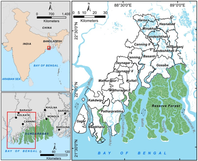
The Indian Sundarbans is part of the larger Sundarbans region located in the west of the tidally active lower deltaic plain of the Ganges-Brahmaputra-Meghna river basin (See Figure 1). It hosts part of the world’s largest contiguous mangrove forest spread over parts of Bangladesh and India that are designated as World Heritage[1] and Ramsar sites.[2]
Figure 1. Indian Sundarbans ecoregion
In the Indian Sundarbans ecoregion, there were 100-odd deltaic islands at the time deforestation began in the 1770s in the hands of the East India Company. Of these islands, 46 are still forested and account for 42.45 percent of all mangrove habitats found in all of India.[3] The remaining islands—deforested at different times until 1943—have been settled as villages that practice agriculture. The total population in the region—located in the North and South 24 Parganas districts of West Bengal and subdivided into 19 sub-districts—is 4.5 million as per the 2011 Census.[4]
During the British colonial period, over half of the mangrove forests were cleared but the process of settlement was not easy. Tropical cyclonic storms caused setbacks to such enterprise and successive administrations had to forego land revenue which was the primary objective behind forest clearance and settlement in the region.
According to Pargiter’s account (1934),[5] “In 1811, the project of clearing Sagar Island (the westernmost and the largest island) was initiated under commercial terms. After initial hiccups, reclamation commenced in 1819 with construction of embankments, clearing of land, digging of freshwater tanks and settling cultivators. Five settlements made considerable progress by 1833 when a storm struck in May and almost all was lost. Subsequent storm strikes happened in June 1842, October 1848, and again in June 1852 when settlers almost abandoned the island. To encourage settlers to stay back, all taxes were suspended until 1863. As the tax-free period expired, surveys were conducted afresh for tax assessment but another cyclonic storm struck on 5 October 1864 and wrought great havoc. Yet another storm struck in November 1867 that reduced the cultivated area on the island to just about 440 hectares. Due to these repeated calamities it was proposed that the island be made revenue-free forever, and fresh grants of land, free of revenue were made during 1875-77 for six settlements.”[6]
Indeed, storms are so common in this part of the coastal Bay of Bengal that the first meteorological observatory in India was established in Calcutta in 1785, and the term ‘cyclone’ was coined in the region. “The term was introduced in the second edition of The Sailor’s Horn-book for the Law of the Storms, by Henry Piddington in 1848. By then, Piddington had been studying storms and publishing articles on the topic in the Journal of the Asiatic Society of Bengal for ten years. In 1853, he had advised against building Port Canning because of the vulnerability of the location to storms. He did not live to see the port being built. Port Canning was devastated in 1867, by a storm and abandoned.”[7]
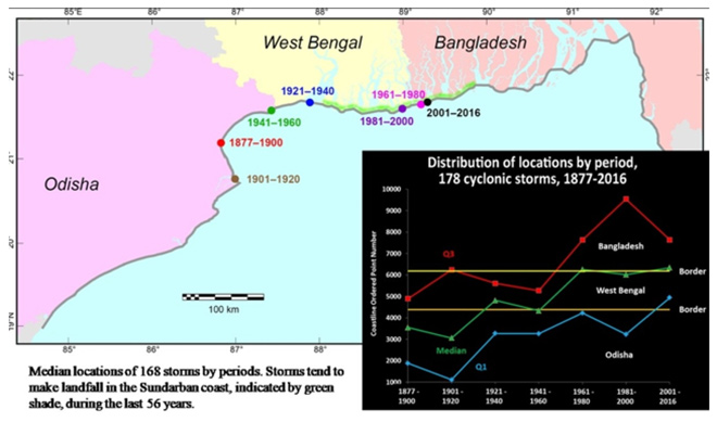
In more recent times, since cyclones began to be named in 2006, the Sundarbans region has seen Sidr in November 2007, Rashmi in October 2008, Aila in May 2009, Bulbul in 2019 and the latest, Amphan on 20 May 2020, while several others like Bijli, Roanu, Titli and Fani narrowly passed it by. The long-term trends of cyclonic storm landfalls in the region (Bangladesh, West Bengal and Odisha) between 1877 and 2016[a] show that despite pronounced shifts across time periods, the median location of cyclones has shifted eastward. The highest-impact zones are currently found in northern Odisha and the Sundarbans region of West Bengal (See Figure 2).[8]
Figure 2. Cyclone landfall in Northern Bay of Bengal Coast, 1877-2016
Source: Dasgupta et al., forthcoming
Scientists project an increase of about 50 percent in the post-monsoonal cyclogenesis by 2041-2060 as a result of warming of the sea surface due to increased greenhouse gas concentrations in the atmosphere.[9] However, it is difficult to obtain a clear understanding of anthropogenic climate change manifestations on extreme storm occurrences as current climate modelling systems cannot make accurate representations of finer-scale physical processes.[10]
Each time a cyclone has hit the Sundarbans, it has given rise to a crisis situation for the people and the administration, and on each occasion the attempt has been to return to the pre-calamity conditions.[11] “During the passage of a single tropical cyclone, the loss and damage inflicted by a few hours’ battering by waves, winds, and surges can undo the gains from many years of accumulative processes.”[12] It is therefore not surprising that the incidence of poverty and development deficit are high in the region.[13]
Rain-fed paddy agriculture has been the main occupation of the settlers from colonial times due to historical antecedents.[14] Other livelihood options barring fishing and fishery are practically non-existent, especially in the forest adjoining sub-districts. In the Indian Sundarbans, access to modern energy services remains a challenge, constricting the basket of possible productive activities.
To be sure, climate risk is not uniform across the entire region. In the south-western sub-districts of Sagar, Namkhana and Patharpratima, there are villages where agriculture is no longer practiced because of recurrent brackish water inundation or erosion or submergence of land parcels.[15] Land owners and possessors are therefore unable to monetise their assets. While such households are occupationally and sometimes physically displaced, they are compelled to stay for lack of adequate financial and social capital.
Under such circumstances, a question looms large: what should be the mode of adaptation? In many cases, the processes of in-situ adaptations through accommodative or resistive (protective) infrastructure fail. In other instances, habitation and liveability have become impossible. The impacts of global warming and climate change will only heighten the vulnerability of such regions. Therefore, adaptation policy must weigh options between possible approaches categorised as ‘manage/accommodate’, ‘protect’, and ‘retreat’.
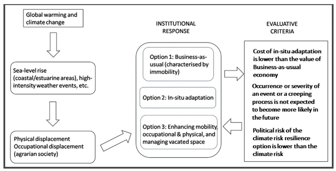
Generic Adaptation Decision Framework (GADF)
It is important to introduce the concept of a Generic Adaptation Decision Framework (GADF) to help rationalise between choices of in-situ risk reduction (manage/accommodate and protect), and strategic retreat. The authors have presented this framework (See Figure 3) in an earlier article.[16] The framework argues that in locations where non-diminishing socio-economic well-being can be ensured through adaptive or accommodative infrastructure, in-situ risk reduction is the option.[17] This, however, needs to satisfy the following conditions: (i) that the cost of in-situ adaptation is lower than the value of the business-as-usual economy at that location; (ii) that the occurrence or severity of an event or a creeping process[b] is not expected to become more likely in the future; and (iii) that political risk of the climate risk resilience option is lower than the climate risk.
In other words, if the cost of protection is higher than the value of what is sought to be protected, state actors will find it hard to justify such investment despite second-order risks to political systems and their legitimacy. On the other hand, if the net value (benefits minus the costs of ex-situ adaptation) of ex-situ adaptation economy is the highest among all options, it creates a case for organic population movement, as well as state action in that regard.
This decision-making framework rests on a comprehensive valuation framework entailing potential monetary and non-monetised values of economic benefits and costs, as well as associated values of ecosystem services or their losses. The values across scenarios lead to a “comparative statics” phenomenon, thereby helping the conclusion on which scenario yields a higher measure of net well-being. The scenarios are generally assumed as mutually exclusive, so as to show clear directions to the decision-makers.
Climate risk: Resilience Options for the Indian Sundarbans
This section outlines three mutually exclusive scenarios emerging from three approaches of adaptation categorised as ‘manage/accommodate’, ‘protect’, and ‘retreat’.[19]
‘Manage/accommodate’
For the vast majority of the human population of the Sundarbans, the possible outcomes of cyclonic storms are loss of homes and crops.[c] Due to high incidence of poverty, most homes are made of non-sturdy material (kutcha houses) with thatched (or tiled or sheet metal) roof that can easily get blown away by high winds, and mud walls that collapse in case of storm surge. Building climate risk resilience under such circumstances would involve making all homes permanent to reduce sensitivity.
The Pradhan Mantri Awas Yojna-Gramin (PMAY-G), a housing programme of the Government of India for the rural poor could be leveraged for the purpose. The programme applies to landless households too, provided the concerned state government allots land to the landless for the purpose. Each rural household in the plains is eligible for an assistance of INR 0.12 million.[20] Estimating conservatively, public expenditure for converting all impermanent houses in the Sundarbans would be about INR 63 billion.[21] This is based on the 2011 Census figure of 884,073 households across 19 sub-districts of the region, at the least, 60 percent of these are kutcha.[22]
Storm surges inundate agricultural fields and freshwater ponds. Depending on the season, post- or pre-monsoon, not only are crops lost, but land also becomes unsuitable for freshwater paddy agriculture for a number of seasons. At best of times, prospects of farming are poor in the region due to low irrigation intensity between 2.36 and 19.05 percent, and cropping intensity between 101.31 and 171.05 percent. Agriculture is unable to sustain the population, the person-cropland ratio being 14 persons per hectare of gross cropped area.[23] Economic necessity drives 18 percent of working adults to seek earnings in areas away from the village.[24] Building resilience to climate risk is difficult under such circumstances. Nevertheless, use of salt-tolerant paddy varieties to reduce sensitivity would ensure harvest in subsequent seasons following a storm surge event. However, yields of salt-tolerant paddy varieties are low.[25] Building resilience to climate risk would mean ensuring availability of the requisite knowledge of farming salt-tolerant paddy seeds, and availability of salt-tolerant paddy seeds for a range of soil salinity conditions that yield better than conventionally used paddy varieties to compensate for the shrinking agricultural land.[26] Such seeds are not readily available.
Addressing inundation due to storm surge and sea level rise is a greater challenge due to low elevation of the inhabited islands. Learning to live with water would have to be the option under the manage/accommodate approach. In order to reduce sensitivity, floor level of homes and other buildings need to be of a certain height to avoid flooding, and drainage network would have to be enhanced and integrated with inland wetlands to improve adaptive capacity.
‘Protect’
Under the ‘protect’ approach, the entire length of embankments in the Indian Sundarbans to protect inhabited islands would have to be upgraded to reduce sensitivity with dredged riverbed materials and/or by local earth from countryside, along with block pitching on riverside slope. The Irrigation and Waterways Department of the Government of West Bengal maintains about 3221 km of embankment in the Indian Sundarbans spread across ten of the 19 sub-districts. About 183 km of embankment has been upgraded or is underway at a cost of INR 13.89 billion according to 2010 prices.[27] At this rate, upgrading the entire length of embankment would cost about INR 236 billion.[28]
‘Strategic and Managed Retreat’
‘Retreat’ in the Indian Sundarbans is already happening – moving people and assets out of harm’s way – but typically as an ad hoc measure to reduce risk, and as an individual goal. Institutionally adopting the ‘strategic and managed retreat’ approach would mean that certain areas in the Sundarbans would have to be relinquished pre-emptively to reduce exposure. These places are experiencing rapid erosion due to which maintaining embankments at these locations is increasingly becoming more challenging and expensive. These locations are vulnerable to inundation caused by a surge of even less than two metres in height.[d] Villages across 28 gram panchayats with a total population of about 0.6 million (as per Census 2011) from eight of the sub-districts are exposed to this risk. Given the number of households at risk, the cost of managed retreat to governments is high.
Retreat could be integrated into long-term development goals and address social, cultural, psychological and long-term economic consequences of the process for those who retreat (source population) as well as those who receive people who retreat (host population).[29],[30] A similar path is being followed in Bangladesh, in terms of increasing the capacity of cities to accommodate migrants.[31] The country’s Ministry of Social Welfare (MoSW) is in the process of executing a project (until 2022) to make recipient cities such as Khulna, Rajshahi, Satkhira, Barishal and Sirajganj capable of accommodating internal migrants displaced due to degradation of the natural habitats on which their livelihoods depend.[32]Such conditions, as in the case of the Indian Sundarbans, are negatively affecting people’s living conditions and social support networks in rural areas. This is a followup to a similar project that ended in 2017.[33]
The ongoing project offers climate migrants income-generating opportunities, assistance to improve their access to public social services and finances, and works to increase the capacity of the cities to accommodate migrants through strengthening of administrative structures.
Initiatives as in Bangladesh, complemented by retreat legislation to prevent the sale, transfer, reconstruction, and bequeathing of existing properties of migrants that will be increasingly exposed would help gradually disestablish these properties when present owners are deceased or structures are damaged. At such time, government could progressively buy back the properties as they become available.[34] Implemented this way, retreat would deliver not only economic development but also nature conservation if the vacated land is repurposed for mangrove regeneration, with the possibility of deriving private benefits if the buy-back option is not exercised. A study entailing economic valuation[35] finds that “strategic and managed retreat” yields 12.86 times more benefits than a scenario of “no climate action” (i.e., business as usual) even if the Sundarbans survives the onslaught of global warming.
Decision-making for Resilience to Climate Risks
A minimum expenditure of INR 300 billion is required for combining manage/accommodate and protect approaches to make homes and inland livelihoods resilient to climate risks. Both approaches, taken on their own, have too many residual risks, and non-diminishing socio-economic well-being cannot be ensured in-situ.
The question is whether such expenditure of public money satisfies the three conditions.[e] In 2009, the Sundarbans’ GDP was estimated at INR 134 billion.[36]However, local public support for the expenditure is high, implying that if the expenditure were to be made, it can enhance political capital. In other words, while the first two conditions are not met, the third condition easily is. While about one-fifth of the households have a family member working as migrant working elsewhere, there is little public support for the managed and strategic retreat option that integrates long-term development. To be sure, political risk associated with retreat is high. Nevertheless, policy options in the climatically vulnerable Indian Sundarbans must be explored to achieve development and conservation goals, besides building climate risk resilience.
This section offers policy prescriptions for integrating strategic retreat into long-term development goals for the Indian Sundarbans.
Policy prescriptions
Using Socio-Economic and Caste Census 2011 data (or the latest available), identify the population most at-risk to storm damage and storm surge damage.
Provide assistance to identified households to access PMAY-G benefits.
Provide salt-tolerant paddy seeds and farming knowledge to agricultural families from among the identified households.
Identify at-risk households with migrant workers and provide them with income-generating opportunities, improved access to public social services, and finances at their locations.
Identify urban/peri-/semi-urban areas and invest in their capacity to accommodate migrants, as well as address social, cultural, psychological, and economic needs of both the migrants and the host populations.
Identify at-risk locations prone to erosion and submergence and specify threshold level of mean sea level (or some other appropriate measure) when retreat legislation is invoked at these locations.
Enact retreat legislation that prevents the sale, transfer, reconstruction and bequeathing of existing properties in at-risk locations.
Offer buy-back of properties in at-risk locations when present owners are deceased or properties are destroyed by a storm event.
Repurpose vacated land for mangrove regeneration with the possibility of deriving private benefits if buy-back option is unexercised.
Promote research to understand the barriers to retreat approach that integrates long-term development goals.
Conclusion
For areas that are vulnerable to impacts of climate change, there are no market-based solutions and relying on a utilitarian approach will fail.[37] It is therefore appropriate to adopt an approach that incorporates retreat into long-term development goals.[38],[39] A rights-based approach that simultaneously provides opportunities for poverty alleviation, extension of social justice, and strengthening of human rights of populations severely affected by climate change impacts—would address the ‘managed’ part of retreat. In case of the Sundarbans, the ‘strategic’ part of retreat is addressed by the additional benefit of regenerated and functioning ecosystem just north of the Bay of Bengal in the vacated high-risk areas.
It is common in democracies for major policy decisions and initiatives to be approved by elected executives.[40] It is therefore logical that elected executives will consider the political risk of policy initiatives and reject those that carry unacceptable political risk. In the context of coastal inundation risk, the ‘manage/accommodate’ and ‘protect’ approaches are preferred not only by the elected executives but also by the residents despite the fact that gains made over years are often lost during the next high-intensity weather event. Retreat, meanwhile, if ‘strategic’ and ‘managed’, has the highest effectiveness with little immediate political risk since it is not undertaken at once but over generations.
There is also opposition among academics who have posed the question regarding retreat to residents of vulnerable locations. This could however be simply a case of a wrong question being directed at a wrong target. The better question to ask would be the willingness to return to vulnerable locations to those who have managed to escape the situation and have been able to establish themselves not at the margins, but within the mainstream society in less vulnerable but densely packed locations. Effective adaptation policy development, therefore, requires retreat options to be viewed not as defeat but as advancement in a different direction in pursuit of long-term development goals.
About the Authors
Anamitra Anurag Danda is a Senior Visiting Fellow at ORF, Kolkata.
Nilanjan Ghosh is Director of ORF, Kolkata.
Jayanta Bandyopadhyay is a Distinguished Visiting Fellow at ORF, Kolkata.
Sugata Hazra is Professor of Coastal Zone Management at Jadavpur University.
Endnotes
[a]As recorded by the Bangladesh Meteorological Department, Indian Meteorological Department, and the IBTrACS database maintained by the Global Data Center for Meteorology and operated by the United States National Oceanic and Atmospheric Administration (NOAA).
[b] Also referred to as slow-onset disaster, and includes processes such as erosion and subsidence.
[c] This is mostly in the case of post-monsoon occurrences; pre-monsoon cultivation is significantly lower. Relative to loss of crops and homes, loss of lives due to cyclonic storms can be described as insignificant.
[d] A storm surge of about 4-6 meters above Astronomical Tide was predicted by the India Meteorological Department in case of cyclone Amphan that made landfall in the Sundarbans region on 20 May 2020.
[e]These conditions are: (i) the cost of in-situ adaptation is lower than the value of the business-as-usual economy at that location; (ii) the occurrence or severity of an event or a creeping process is not expected to become more likely in the future; and (iii) political risk of the climate risk resilience option is lower than the climate risk.
[8] Susmita Dasgupta, et al., Coping with Climate Change Vulnerability in the Sundarbans Lessons from Multidisciplinary Studies (Washington, DC: The International Bank for Reconstruction and Development / The World Bank, forthcoming).
[9] O.P. Singh, “Simulations of frequency, intensity and tracks of cyclonic disturbances in the Bay of Bengal and the Arabian Sea,” Mausam 60 no. 2 (2009): 167-174.
[10] R. Krishnan et al. Eds., Assessment of Climate Change over the Indian Region(Singapore: Springer, 2020).
[12] Susmita Dasgupta, et al., Coping with Climate Change Vulnerability in the Sundarbans Lessons from Multidisciplinary Studies (Washington, DC: The International Bank for Reconstruction and Development / The World Bank, forthcoming), 12.
[13] A.A Danda et al., Indian Sundarbans Delta: A Vision (New Delhi: WWF-India, 2011).
[15] Tuhin Ghosh, R. Hajra and A. Mukhopadhyay, “Island erosion and afflicted population: crisis and policies to handle climate change” in International Perspectives on Climate Change, ed. W.L. Filho (Berlin: Springer, 2014), 217-225.
[19] Robert J Nicholls et al., “Coastal systems and low-lying areas” in Climate Change 2007: Impacts, Adaptation and Vulnerability, Contribution of Working Group II to the Fourth Assessment Report of the Intergovernmental Panel on Climate Change, ed. M.L. Parry, et al. (Cambridge: Cambridge University Press, 2007), 315-356.
[22] In West Bengal, about 60% of the houses are of impermanent nature. This figure in the Sundarbans region cannot be lower than the state average. “Predominant Material of Wall of Dwelling Room (Rural)”, Socio Economic and Caste Census 2011, accessed on June 11, 2020.
[23] Sugata Hazra, Tuhin Bhadra, and S.P. Sinha Ray, ”Sustainable Water Resource Management in the Sundarban Biosphere Reserve, India” in Ground Water Development – Issues and Sustainable Solutions, ed. S.P. Sinha Ray (Singapore: Springer, 2019), 147-160.
[25] Amales Misra and S. Mitra, “Enhancement of Productivity of Traditional Paddy with Diversified Organic Inputs at Sagar Island, South 24 Parganas, West Bengal, India,” IISRR int. j. res. 6 no. 1 (2020): 83-99.
[26] A study by Jadavpur University School of Oceanographic Studies observed conversion of agricultural land to settlements during 2001-2009. Agricultural land shrank from 2149.615 sq km to 1691.246 sq km. S. Hazra, K. Samanta, A. Mukhopadhyay, and A. Akhand, Temporal change detection (2001-2008) study of Sundarban (Kolkata: School of Oceanographic Studies, Jadavpur University, 2010), accessed June 8, 2019.
[29] A.R. Siders, M. Hino, and K.J Mach, “The case for strategic and managed climate retreat,” Science 365 no. 6455 (August 2019): 761-763, https://doi.org/10.1126/science.aax8346.
[30] A.A Danda et al., Indian Sundarbans Delta: A Vision (New Delhi: WWF-India, 2011).
[36] “INR 6.7 billion (annually, which) is equivalent to about 5 percent of the Sundarbans’ gross domestic product (GDP) in 209`.” Building Resilience for Sustainable Development of the Sundarbans (Washington, DC: The International Bank for Reconstruction and Development / The World Bank, 2014), 15.
The views expressed above belong to the author(s). ORF research and analyses now available on Telegram! Click here to access our curated content — blogs, longforms and interviews.
Anamitra Anurag Danda is Senior Visiting Fellow with ORF’s Energy and Climate Change Programme. His research interests include: sustainability and stewardship, collective action and institution ...
Dr. Nilanjan Ghosh is a Director at the Observer Research Foundation (ORF), India. In that capacity, he heads two centres at the Foundation, namely, the ...
Jayanta Bandyopadhyay is a Visiting Distinguished Fellow. He is a researcher and author on science and the natural environment. He received his Ph. D. in ...

 PDF Download