India-Bangladesh Trans-Boundary River Management: Understanding the Tipaimukh Dam Controversy
This brief offers a way to rethink the ongoing dispute between India and Bangladesh over the former’s plan to build a high dam on River Barak (known as Surma-Kushiyara and Meghna in Bangladesh) at Tipaimukh in the state of Manipur. It identifies the origins of different sources of water for Bangladesh’s Haor, the region that is widely feared to be under threat by India’s planned dam. The brief recommends the conduct of a comprehensive study for assessing the potential impact of the project on the Haor in order to separate the myths from the facts and inform decision-making around the project.
This brief is part of ORF’s series, ‘Emerging Themes in Indian Foreign Policy’. Find other research in the series here:
Attribution:
Jaya Thakur, ‘India-Bangladesh Trans-Boundary River Management: Understanding the Tipaimukh Dam Controversy’, ORF Issue Brief No. 334, January 2020, Observer Research Foundation.
Introduction
Neighbours India and Bangladesh share a largely cordial relationship. To begin with, both are part of sub-regional organisations like the Bay of Bengal Initiative for Multi-Sectorial Technical and Economic Cooperation (BIMSTEC) and the BBIN (Bangladesh, Bhutan, India and Nepal) initiative, where they find common ground on issues facing the neighbouring countries. India’s ‘Act East Policy’[1] further reinforces the bilateral relationship. So far, India and Bangladesh have signed more than 100 Memorandums of Understanding (MoU) covering various sectors including trade, transport and water allocation.[2]
This is not to say, however, that there are no thorns in the relationship. Indeed, there are unresolved issues between the two related to trans-boundary river management in the Ganga-Brahmaputra system. Overall, India and Bangladesh have 54 trans-boundary rivers between them, all of which are part of the drainage system of the Ganga-Brahmaputra-Meghna (GBM) basin. The Padma (the Ganga), the Jamuna (the Brahmaputra) and the Meghna (the Barak) and their tributaries are integral in maintaining food and water security in Bangladesh. In most of these cases, Bangladesh is the lower riparian. This causes concern in Bangladesh that India—being both the upper riparian and first to develop the water resources—can have far more disproportionate control over the rivers. Compounded by the lack of transparent data regarding trans-boundary rivers, such concern can lead to a more serious conflict between the two otherwise friendly neighbours.
The issues between India and Bangladesh regarding water resource allotment can be traced to the time Bangladesh was still East Pakistan. In 1961, India began construction of the Farakka Barrage—which would be operational by April 1975—to divert a portion of dry-season flow and increase the navigability of Calcutta (now Kolkata) port. When India began its preliminary planning for the project in 1950-51, Pakistan immediately expressed concerns over the potential effect of the project on East Pakistan. Between 1960 and 1969, India and Pakistan held five meetings to discuss the issue, where India maintained that the negotiations be based on facts after exchange of relevant data.[3]
Soon after the independence of Bangladesh in 1971, the Joint River Commission was formed between India and Bangladesh in 1972. In a joint declaration issued on 16 May 1974, the prime ministers of Bangladesh and India acknowledged the need for the flow augmentation of the Ganga in the lean season to meet the requirements of both countries. On 18 April 1975, Bangladesh allowed India to divert 310-450 m3/second of water from the Ganga for the period 21 April to 31 May 1975.[4] However, decades of turmoil would then engulf Bangladesh, and bilateral cooperation on issues such as water resource development took a back seat. Still, both India and Bangladesh had nearly a hundred meetings regarding the matter. A five-year agreement was signed on 5 November 1977. In this period, however, no long-term treaty was put in place regarding water sharing of the Ganga.[5] Negotiations resumed following the formation of the Awami League government in 1996, which would lead to the signing in December 1996 of a 30-year treaty on sharing of the Ganga water. This long-term treaty relaxed the tensions between India and Bangladesh regarding the management of trans-boundary Ganga.
In October 2019, Bangladesh and India signed an MoU allowing India to take 1.82 cusec (cubic feet per second water from the Feni river[6] (until an agreement is signed) for supplying drinking water to Sabroom, a town in India’s Tripura.[7] The MoU, however, continues to cause concern within Bangladesh that it might have a negative impact on its Muhuri-Feni Irrigation Project.[8] Meanwhile, a treaty for sharing the water of river Teesta[9] is yet to be signed.[10] The water of Teesta is extremely important for both India and Bangladesh, as increasing dry season paddy in both West Bengal (India) and Rangpur (Bangladesh) has raised the water demand in the basin .[11]
The Proposed Tipaimukh Dam: An Overview
A more recent source of discord between India and Bangladesh is India’s plan to build an embankment dam over the river Barak, the upper part of river Meghna in India, to control flooding and generate power. The dam will be located in Churachandrapur District, Manipur, and is expected to submerge parts of Manipur and Mizoram. The structure when built would be 162.8 meter high with around 18 meter base from Mean Sea Level (MSL), 390 meter long and the Maximum Water Level (MWL) is supposed to be 178 m high from and Full Reservoir Level (FRL), 175 meter MSL.[12]
The project has been controversial from its inception. The dam, one of the largest in India’s Northeast, is being planned on one of the most seismically volatile regions in the world. The region is situated in one of the biodiversity hotspots[13]of not only India but the world. It is also the home of the Hmar people, part of the Kuki tribe,[14] whose cultural identity and very lives are intertwined with the river. They are opposing the dam, saying it would destroy their lives.[15],[16]
The 2007 Environmental Impact Assessment (EIA) report observed that the project will permanently submerge some 291.5 sq. km. at FRL (275.5 sq. km. in Manipur and 16 sq. km. in Mizoram).[17] According to some news reports, the dam will lead to permanent submergence of 311 sq. km. area which includes 229.11 sq. km. of reserve forest and 81.89 sq. km. of agricultural and settlement land. The 1984 report states that 31 villages will be displaced; in 1998 the official number fell to 15. The NEEPCO record of 2000 further reduced it to eight, while the AFCL report of 2007 declares the possible displacement of 12 small villages.[18] Other independent reports have concluded that the 311 sq. km. permanent submergence will lead to the displacement of 90 villages with 1310 families.[19]
The inconsistencies in different versions of the EIA caused turmoil between authorities and the local people who face the possibility of being displaced. According to the official EIA of 2007, the submerged area will include reserved forests, unclassed state forests, rock outcrops, cultivated lands including wet rice cultivation, gardens and orchards, wasteland, human settlements and other private land. Some 100.02 sq. km. area under reserved forest will be affected by the project.[20]
As the river is a major trans-boundary river between India and Bangladesh, the proposal for this large dam raised concerns in lower riparian Bangladesh over the question of diminished flow in Surma-Kusiyara and especially the possible negative impact on the Haor region in Sylhet district. A number of articles have been published in other countries highlighting the potentially disastrous effects of the dam on Bangladesh.[21]
This brief aims to offer a more objective analysis of the proposed dam. Much of existing literature on the issue tend to magnify the dire predictions on the negative effects of the project,[22] especially on the Haor region. Some articles and analyses also promote misconceptions regarding the project, for instance by adding on the issue of the proposed Fulertal Barrage.[23] The Fulertal Barrage was once attached to the project[24] but according to the 2007 EIA, it is not included in the present form of the project being developed and no amount of water is supposed to be diverted from Tipaimukh project for irrigation according to the present proposal.[25] Moreover, none of these articles have tried to assess the major source of water for Haor region, the very wetland that is supposed to become a desert as a result of this project.[26] To be sure, there is a knowledge gap in this regard, and this brief aims to fill that.
The objective of this brief is to clear misconceptions regarding the basin and the project that can cast a shadow over Indo-Bangladesh water diplomacy. It will do so through a perspective used rarely in this matter. It analyses the major source of water for the Haor region, and the maximum amount of the flow that can be affected by the periodic restrictions in the dry season.
The first section of the brief gives an overview of the basin, and the second offers a history of the controversy. The third part uses the average flow data from three points of the main stream and compares them to determine the main source of water of the Haor region in Bangladesh as well as how much of the flow will potentially be affected by the restrictions.
I. THE BASIN AND THE DAM
The Basin
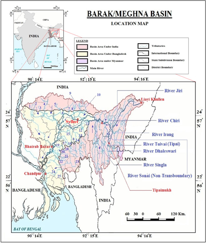
The Barak-Meghna River System is a river complex in the Indian subcontinent, one of the three that form the Ganga-Brahmaputra-Meghna Delta which is the largest on earth. The course of Barak-Meghna is one of the most complex in South Asia; to understand the issues in the basin, one needs to understand the river complex. The basin covers parts of India, Bangladesh and Myanmar. It has a total area of 82,000 sq.km of which 47,000 sq. km. (or 57 percent of the total area) is located in India and 35,000 (43 percent of the total area) is in Bangladesh.[27] The basin extends between 89°50’ to 94°0’ east longitudes and 22°44’ to 25°58’ north latitudes.[28]
Figure 1: Location of Barak/Meghna Basin
Source:Modified by the Author from Nishat et al,2014[29]Source:Nishat et al, 2014[30]Source: Sinha et al, 2018[31]
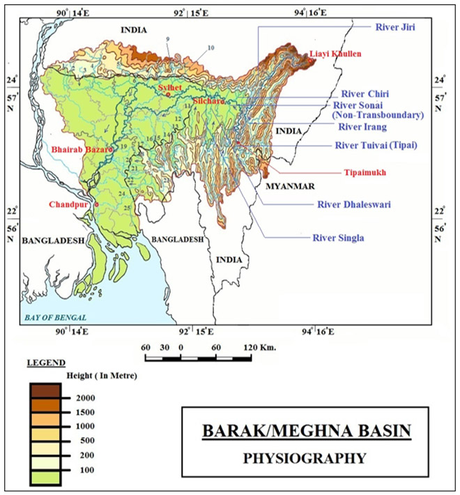
The main valley is like an amphitheatre, framed by hills on three sides, and opening into the plains of Sylhet in Bangladesh to the west. In this basin there are two ranges, Meghalaya and Purvachal. It is bounded by Garo Hill, Jaintia hills and Barail range separating it from the Brahmaputra basin on the north, by the Naga, Lushai and Manipur hills on the east and by Mizo hills and territory of Bangladesh on the south and west (See Figures 1 and 2). The plains of Cachar are formed by the alluvial sediments of the floods of the Barak, which flows through the area from east to west.
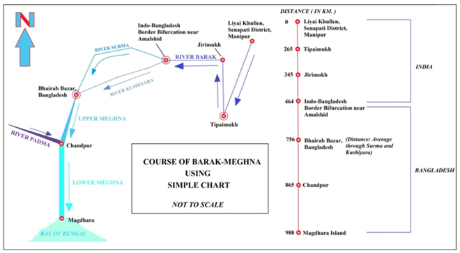
The main river rises in the Manipur Hills near Liai Kullen village of northeast India as the Barak River and flows west becoming the Surma and Kushiyara River and then flows south as the Meghna River (after the two former rivers join again near the north of Bhairab Bazar) to the Bay of Bengal.
Near Tipaimukh (the proposed site of the dam) it is joined by Tuivai or Tipai river and takes almost a 180-degree hairpin bend to move northwards, creating the boundary of first Manipur and Mizoram and then, Manipur and Assam. At Jirimukh, where Barak is joined by tributary Jiri from the north and the joint flow takes an almost-90-degree angle at Jirimukh, leaving the mountain and flowing westwards entering the Cachar Plains of Assam.[32]
The principal transboundary tributaries of the Barak from India are the Jiri, the Dhaleshwari (Tlawng), the Longai, the Madhura, the Sonai (Tuirial), the Rukni and the Katakhal. At the border with Bangladesh, 30 km. west of Silchar (District Cachar, Assam, India) and near Amalshid (Bangladesh) the river divides with the northern branch called the Surma River and the southern the Kushiyara River. This is where the river enters the Sylhet Depression (or trough) which forms the Surma and Kushiyara Basin.[33] From its origin down to its bifurcation at the India-Bangladesh border, Barak River is around 464 km. long.
Surma
From Amalshid, the northern distributary, Surma follows the India-Bangladesh border for around 26 km., turning south west from there, flowing beside Sylhet and Sunamganj. The Surma is fed by tributaries from the Meghalaya Hills to the north. It is also known as the Baulai River after it is joined by the south-flowing Someshwari River. It meets its southern counterpart, Kushiyara around 19 km. north of Bhairb Bazar.[34]
Kushiyara
The Kushiyara receives tributaries from the Sylhet Hills and Tripura Hills to the south, the principal one from the Tripura Hills being the Manu. When the Surma and the Kushiyara finally rejoin in Kishoreganj District above Bhairab Bazar, the river is known as the Meghna River.[35]
Figure 2: Physiography of Barak/Meghna Basin
Source: Modified by the Author from Oxford India Atlas, 2017[36] and Sinha et al, 2018[37]
Meghna
From Bhairab Bazar down to Chandpur, Meghna is referred to as the Upper Meghna. After the Padma joins, it is referred to as the Lower Meghna. After Chandpur, the combined flow of the Padma, Jamuna and Meghna moves down to the Bay of Bengal in an almost straight line, braiding occasionally into a number of riverines.[38] The estuary of the Lower Meghna is usually taken to stretch from the Rabnabad islands to the Kumira coast in the Bay of Bengal.
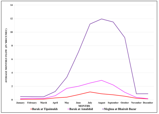
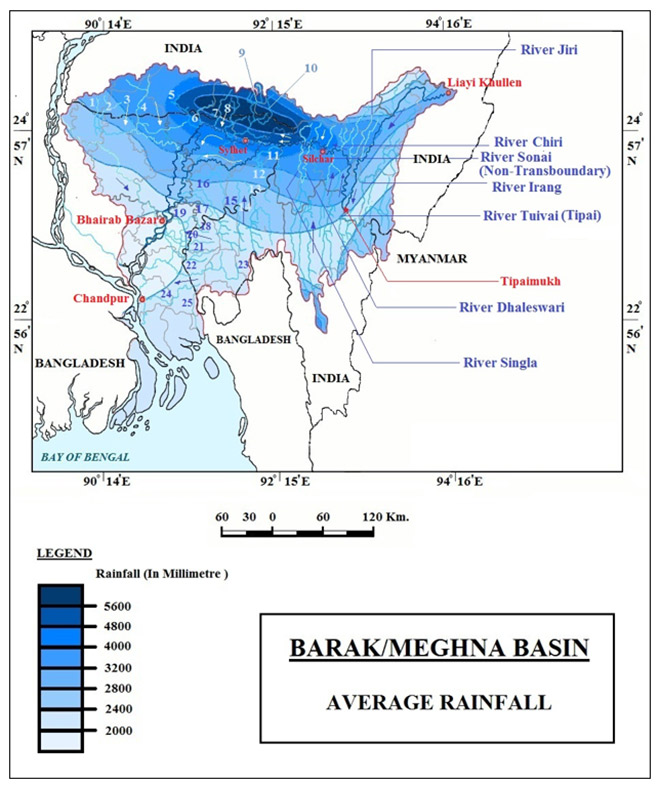
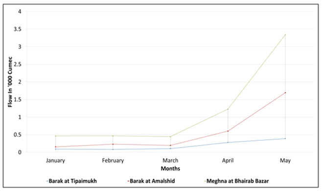
This flow of Meghna (Fig. 3) increases substantially between Amalshid (where Barak enters Bangladesh as Surma and Kushiyara) and Bhairab Bazar (where Surma and Kushiyara meet again to form the Upper Meghna). Meghna is primarily a rain-fed river. It gains most of its water from regions with highest rainfall in the world (Mawsynram, Meghalaya, is the 2nd wettest place on earth in 2019)[39](See Fig.4). In part three it will be discussed how this immense volume of water flowing into mostly Surma increases the flow of the river between Amalshid and Bhairab Bazar. It is also this water that helps create the seasonally inundated wetlands that dominate the landscape of Sylhet.
Figure 3: Hydrograph of Barak-Meghna at Three Points (Stations showed in Chart 1) of the River
Source: Created by the Author with Data from Ministry of Water Resources Bangladesh and Institute of Water Modelling, Bangladesh, 2019
Figure 4: Average Rainfall in Barak-Meghna Basin
Source: Modified by the Author from Bandyopadhyay and Ghosh, 2009[40]
CHART 1: THE COURSE OF BARAK-MEGHNA
*Circled locations are stations for the hydrograph in Figure: 3
Source: created by the Author with reference from Google Earth and Nishat, et al. 2014[41]
The Haors and Beels
Wetlands are the distinctive feature of the Barak-Meghna Basin. Two internationally recognised Ramsar sites—Tanguar Haor (on the Surma River, Bangladesh) and Rudrasagar Lake (on the Gumti River, Tripura, India) – are located in the Barak-Meghna Basin.[42]
Three types of wetlands have been identified in this Basin: Beels (perennial wetlands); Anua (ox-bow lakes); and Haors (seasonal wetlands or floodplain wetlands)
The Haors are unique seasonal wetlands of the basin. They cover almost 43 percent of the Surma-Kushiyara Sub Basin part of the larger Barak-Meghna Basin.[43] They are low-lying marshy depressions that turn into vast bodies of turbid water during the monsoons. The water recedes after the monsoon, leaving fresh nutrient-rich lands for dry season cultivation. The seasonal rainfall patterns in the upper catchment (mostly Meghalaya and partly Manipur) play an important role in sustaining this unique ecosystem.[44]
According to the Master Plan of Haor Areas, Bangladesh,[45] there are about 373 major haors covering an area of 858,000 hectares spread across seven districts (Sylhet, Sunamganj, Habiganj, Netrakona, Kishoreganj, Brahmanbari and Mailvibazar) but a major part of the Haor falls under the four districts of Sylhet Division in the Upper Meghna Basin. These 373 haors cover approximately 43 percent of the total area of the four districts and represent a mosaic of wetlands, rivers, natural streams, canals and floodplains. Some important haors include Dakhar, Gungiajuri, Hakaluki, Kaowadighir, Mukhar, Sumir, and Tanguar. These provide critical habitat for aquatic flora and fauna and seasonal homes to migratory birds, and also support the livelihoods of millions of people.[46]
For example, Tanguar Haor sustains the livelihoods of over 100 surrounding villages (60,000 people). It is also a wintering ground for 30-40,000 migratory waterfowl, and home to at least 10 IUCN Red-Listed species and 22 CITES-listed species. The area of these wetlands fluctuates annually depending on rainfall.[47]
The degradation and loss of wetlands have implications for both the wetland ecology and for biodiversity. These wetlands help store excess rainwater which often causes devastating flash floods downstream in the Upper Meghna Basin, also known as the “rice bowl” of Bangladesh.[48]
II. TIPAIMUKH: THE BIRTH OF A CONTROVERSY
The idea of a dam on Barak as a flood control measure for the Cachar plains first emerged in 1926.[49] However, the present controversy has its roots in much later events. There has been a host of contradictory information and misconceptions about who first proposed the project or what was to be its structure. It is on record, however, that a barrage on the Barak river was discussed by India and Bangladesh at the first meeting of the Joint Rivers Commission held in New Delhi in June 1972.In that meeting, a storage reservoir on Barak River was envisioned for managing flood situation in parts of Assam and Sylhet. India and Bangladesh decided to assess the flood situation jointly for the project.[50]According to the June 2012 statement of then Indian Minister for Water Resources, Pawan Kumer Bansal, Bangladesh agreed with the idea and proposed some modifications in 1974. The relevant documents and minutes were provided in the 6th JRC meeting in November 1973. In 1974, the proposed site of the dam was finalised as the Tipaimukh village in Churachandrapur district in Manipur.[51]In 1978, it was decided that “the concerned Superintending Engineers of the two countries should jointly examine the scope of the Indian scheme of storage dam on Barak river at Tipaimukh.” It was further added that the “potential flood control and other benefits (particularly power) to Bangladesh should be studied expeditiously.”[52]
In the following two decades, Tipaimukh took a back seat. According to a statement of Rao Birender Singh, India’s former Agriculture, Rural Reconstruction and Irrigation Minister, in a Review Meeting of the Ganga Waters Agreement in New Delhi in January 1981, India had carried out detailed explorations and investigations on the Tipaimukh dam but “Bangladesh had not come forward to study the data on scientific and rational basis to discuss the scheme.”[53] In the following two decades, Bangladesh faced immense internal political upheavals that affected its priorities concerning the matter. However, as the political storms in the country calmed down in the 1990s, the issue rose again in the 2000s.
After decades of deliberation on how to control flooding of the Barak and meet additional needs of energy generation, in 1999, the Tipaimukh hydroelectric project was approved and its construction entrusted to the North Eastern Electric Power Corporation Limited (NEEPCO).[54] The proposed dam would be 162.8 m high with around 18 m. base from MSL, 390 m long and the maximum reservoir level is supposed to be 178 m high from MSL. At the height of 178 m. it will cause the submergence of 303.20 sq. km.[55] The dam will also not be a typical run-of the-river-project with water being stored in the reservoir for the generation of electricity and the changes in the river flow regime caused by it might affect the ecosystem of the river.
Concerns in Bangladesh
The proposal of the dam and reservoir created concerns over the availability of water for fishing and agriculture especially in the Sylhet Division of Bangladesh as well as sustenance of the Haor ecosystem mentioned previously, the Haors being one of the Ramsar sites.
A study by Solayman et al. revealed the value of ecosystem services provided by a small part of the total Haor (Tanguar Haor) to be US$2 million per year.[56] The study uses market values method for estimating the economic values of ecosystem services provided by that particular Haor. The methodology and result might be questionable, but it can be at least taken as indicative. The submergence of the Haor in monsoon also replenishes the regional aquifers which in turn support the dry season Boro paddy crop in Bangladesh which is totally dependent on irrigation from groundwater and the tributaries and distributaries of Surma-Kushiyara.
Root of Concern in Bangladesh: Increasing Dry Season Water Demand
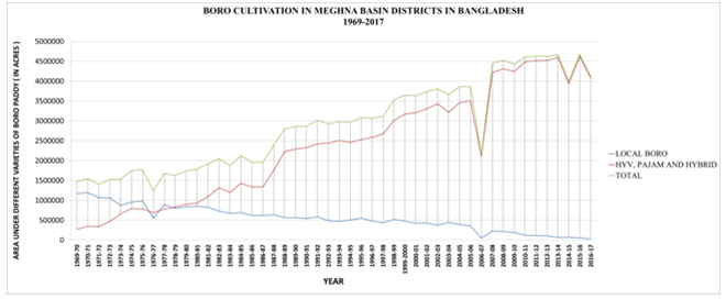
The opposition within Bangladesh is primarily rooted in the fear of drying of the Haor and losing the source of water for irrigation in dry season. In the last three decades, the dry season Boro, especially the high yielding hybrid variety has become immensely popular as a dry season crop in Bangladesh. The area under Boro paddy has increased almost three times (Fig. 5) so has the demand for irrigation water in the dry season as Boro is mostly an irrigated crop.
The Boro season starts from December and extends to late May. The growing period falls in the period from February to April, the driest month of the basin. In the dry period (from January to May) Boro cultivation is the main economic activity of the basin, especially for the Haor region. This is the period when the groundwater level accompanied by the river discharge is the lowest. However, this is also the period when the proposed dam will need to close their gates for an extended period to keep the pressure required for producing hydroelectricity from the dam, which can have an effect on the ecosystem services of the river, ultimately creating a negative impact on economic activities.
Figure 5: Boro Paddy Cultivation in Bangladesh Part of Meghna Basin
Source: Created by the Author with Data from Ministry of Agriculture, Bangladesh, 2018
III. TRACING THE SOURCE OF WATER OF HAOR AND THE MAXIMUM POSSIBLE EFFECT CAUSED BY TIPAIMUKH IN THE DRY SEASON
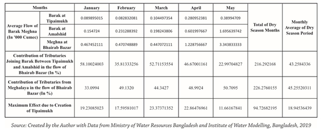
Considering the flow of Meghna at Bhairab Bazar, a huge portion of that flow is contributed by the tributaries joining Surma and Kushiyara from Meghalaya and Tripura (Table 3), especially from Meghalaya. Even in the dry season, these tributaries contribute 58.10 percent, 35.81 percent, 52.71 percent, 46.67 percent, 22.997 percent of the water at Bhairab Bazar, respectively (See Table 3). Only an average of 19.23 percent, 17.59 percent, 23.37 percent, 22.86 percent and 11.66 percent, respectively, for the months of January, February, March, April and May is contributed by the main Barak river upto Tipaimukh. (See Table 3). It should be mentioned that the pickup barrage at Fulertal is outside the scope of the project at present.[57] It is only this amount of water that will possibly be affected by the proposed Tipaimukh dam. In the present scenario (without the Fulertal Barrage) as the dam needs to release the water to produce electricity, the total amount of water released will not be affected, overall. However, the daily and weekly hydrograph will indeed face a change. The effect of such change will be limited to the aforementioned average values even during the dry season months.
Figure 6: Comparison of Average Monthly Flow of Barak-Meghna at Three Points in Dry Season (1989-1993)
Source: Created by the Author with Data from Ministry of Water Resources Bangladesh and Institute of Water Modelling, Bangladesh, 2019
Table 3: Assessing the contributions of different tributaries of Barak-Meghna at Bhairab Bazar in Dry Season (1989-1993)
Conclusion
The situation of the proposed Tipaimukh dam has been in limbo for the past few decades. The issue gets a prominent mention in every annual report of the JRC, including the most recent one of 2017-18. The Indian government appears to be serious about developing hydropower in the northeastern states. In March 2019, the Union Cabinet approved a number of measures to promote the country’s hydropower sector. In July 2019, the Cabinet Committee on Economic Affairs approved INR 1600 Crore (approximately 224 Million USD) for the Dibang Multipurpose Project. The project is moving ahead after a long time being rejected twice by the Forest Advisory Committee (FAC) of the Ministry of Environment, Forest and Climate Change (MoEF&CC), once in July 2013 and again in April 2014. India might be entering a new phase of boosting large multipurpose projects in the northeastern states with an aim to materialise projects that are stalled. Tipaimukh is one of the largest of those. Some minor construction had even begun around 2008 before it was stalled due to local protests and rejection from FAC. However, with similar stalled projects like Dibang getting the go-signal, there is a chance that India might start to rethink Tipaimukh soon. Before India does so, it needs to have a clear idea about how water, energy, biodiversity and sediment (WEBS)[58] interact in this basin to create a highly complex system that nourishes the people and economy of both India and Bangladesh. Before the dam is constructed, there should be a complete understanding of its effects (both upstream and downstream). For that, a clear comprehension of this trans-boundary system should be in place, informed by science and data.
Understanding the major source of water of Haor is only a small step to understanding how the project can or cannot affect the ecology of this trans-boundary basin. The impact of the project on the flow of the Haor should be comprehensively assessed through a detailed study that will involve multi-disciplinary experts from both the riparian countries. In the absence of such a comprehensive study, there is a risk of floating misconceptions regarding the project that will likely negatively affect India and Bangladesh’s relationship.
The author would like to thank Dr. Shafiqul Islam (Tufts University), Dr. Wahid Palash (Tufts University) and Mr. Sahadat Hossain (CEO, O. Creeds) for their help in acquiring the needed flow data of Meghna. The author would also like to thank Dr. Anamitra Anurag Danda (Senior Visiting Fellow, ORF), Dr. Jayanta Bandyopadhyay (Visiting Distinguished Fellow, ORF) and Dr. Nilanjan Ghosh (Director, ORF Kolkata) for their inputs for this brief.
ENDNOTES
[1] Dipanjan Roy Chaudhury, “ET Analysis: Indo-Bangla relations enjoy golden period,” The Economic Times. October 08, 2018. https://economictimes.indiatimes.com/news/defence/et-analysis-indo-bangla-relations-enjoy-golden-period/articleshow/66118543.cms?from=mdr (accessed September 20, 2019).
[3] Mohammad Abul Kawser, and Abdus Samad, “Political history of Farakka Barrage and its effects on environment in,” Bandung Journal of Global South 2, no. 16 (2015).
[4] Muhammad Mizanur Rahaman, “The Ganges Water Conflict: A Comparative Analysis of 1977 Agreement and 1996 Treaty.” International Water Law Project 1, no. 2 (2006): 195-208.
[6] Feni is a trans-boundary river between India and Bangladesh. It originates in South Tripura and drains in Sandwip Channel of Meghna estuary. India signed an MoU with Bangladesh in 2019 withdrawal of water from the river for drinking purpose of the people of Sabroom town of Tripura, India. Details taken from:
Soumya Sarkar, “Feni river agreement offers hope, but water sharing remains contentious,” Mongabay, November 6, 2019, https://india.mongabay.com/2019/11/commentary-feni-river-agreement-offers-hope-but-water-sharing-remains-contentious/ (accessed November 15, 2019).
[7] Tribune Desk, “PM: MoU on sharing Feni river water a temporary arrangement,” Dhaka Tribune. November 14, 2019, https://www.youtube.com/watch?v=ubZrAmRxy_M (accessed January 09, 2020).
[8] Soumya Sarkar, “Feni river agreement offers hope, but water sharing remains contentious,” Mongabay, November 6, 2019, https://india.mongabay.com/2019/11/commentary-feni-river-agreement-offers-hope-but-water-sharing-remains-contentious/ (accessed November 15, 2019).
[9] Teesta is an important trans-boundary river between both India and Bangladesh. It is a major tributary to Jamuna (Brahmaputra). Both of the countries, especially the sates of Sikkim and northern parts of West Bengal in India and North Eastern part of Rangpur depend on the water of Teesta. The sharing of the water of Teesta is also a lingering water diplomacy issue between India and Bangladesh. An ad hoc agreement on sharing of the water of Teesta was in place from 1983 to 1985. According to the agreement, India was supposed to get 39 per cent while Bangladesh 36 per cent of the flow volume. After the end of that agreement no further agreement or treaty has been signed. A treaty was supposed to be signed regarding the bilateral distribution of water of Teesta between India and Bangladesh in 2011. But, it could not be finalised due to internal stakeholder objection from India.
[10] “‘No change’ in Teesta water-sharing agreement: Jaishankar,” Business Standard, August 20, 2019, https://www.business-standard.com/article/news-ani/no-change-in-teesta-water-sharing-agreement-jaishankar-119082000656_1.html (accessed November 15, 2019).
[11] Nilanjan Ghosh, “Why India has not been able to resolve the Teesta stalemate,” DailyO, November 23, 2019, https://www.dailyo.in/politics/teesta-india-bangladesh-water-treaty-teesta-water-treaty-sheikh-hasina/story/1/32207.html (accessed January 09, 2020).
[13] According to the information available in the Environmental Information System of the Government of India (http://www.bsienvis.nic.in/Database/Biodiversity-Hotspots-in-India_20500.aspx ) the term “biodiversity hotspot” was coined by British biologist Norman Myers in 1988.It is defined as a biogeographic region characterized both by exceptional levels of plant endemism and by serious levels of habitat loss. Conservation International (CI) adopted Myers’ hotspots as its institutional blueprint in 1989. In 1996, the organization made the decision to the concept. As of the present definition of CI, to qualify as a hotspot a region (i) it must contain at least 1,500 species of vascular plants (> 0.5% of the world’s total) as endemics, and (ii) it has to have lost at least 70% of its original habitat. India has at present three biodiversity hotspots. 1. The Himalayas, 2. The North Eastern Mountains (part of the Indo-Burma Hotspot) and 3. Western Ghats (part of the Western Ghats and Sri Lanka Hotspot)
[14] Vijay Prakash Sharma, The Hmars of Manipur: An Anthopological Exploration(New Delhi: Anmol Publication, 1992).
[15] Aram Pamei, “Havoc of Tipaimukh high dam project,” Economic and political weekly 36, no. 13 (2001): 1045-1048.
[16] Vibha Arora, and Ngamjahao Kipgen, “‘We can live without power, but we can’t live without our land’: Indigenous Hmar Oppose the Tipaimukh Dam in Manipur,” Sociological Bulletin (Indian Sociological Society) 61, no. 1 (January-April 2012): 109–128.
[21] M. Asaduzzaman, and Md. Moshiur Rahman, “Impacts of Tipaimukh Dam on the Down-stream Region in Bangladesh: A Study on Probable EIA.” Journal of Science Foundation 13, no. 1 (January 2015): 3-10.
And
Md Saidul Islam, and Md Nazrul Islam, ““Environmentalism of the poor”:the Tipaimukh Dam, ecological disasters and environmental resistance beyond borders,” Bundang Journal of Global South 3, no. 27 (2016).
[23] Md Saidul Islam, and Md Nazrul Islam, ““Environmentalism of the poor”: the Tipaimukh Dam, ecological disasters and environmental resistance beyond borders,” Bundang Journal of Global South 3, no. 27 (2016).
[24] B. G. Verghese, Waters of Hope: Facing New Challenges in Himalaya-Ganga Cooporation (New Delhi: India Research Press, 2007).
[26] M. Asaduzzaman, and Md. Moshiur Rahman, “Impacts of Tipaimukh Dam on the Down-stream Region in Bangladesh: A Study on Probable EIA,” Journal of Science Foundation 13, no. 1 (January 2015): 3-10.
[27] Masud Hasan Chowdhury, “Meghna River,” Banglapedia, March 2015, http://en.banglapedia.org/index.php?title=Meghna_River (accessed January 27, 2019).
[28] V. Sinha, R. Glémet, and IUCN BRIDGE GBM, Benefit Sharing Oppertunities in the Meghna Basin (Bangkock: IUCN, 2018).
[29] Bushra Nishat, Sanat K. Chakraborty, Md. Imran Hasan, and AJIM Zobaidur Rahman, Rivers Beyond Borders: India Bangladesh Trans-Boundary River Atlas (Dhaka: IUCN, 2014).
[39] “Not Cherrapunji, This Is The Wettest Place On Earth,” published in Inuth, August 09, 2019, accessed September 20, 2019, https://www.msn.com/en-in/travel/tripideas/not-cherrapunji-this-is-the-wettest-place-on-earth/ar-AAFBkAU.
[40]Jayanta Bandyopadhyay, and Nilanjan Ghosh, “Holistic Engineering and Hydro-Diplomacy in the Ganges-Brahmaputra-Meghna Basin.” Economic & Political Weekly 44, no. 45 (November 2009): 50-60.
[45]Master Plan for Haor Areas Vol. II (Ministry of Water Resources, Government of the People‟s Republic of Bangladesh, Dhaka, Bangladesh: Centre for Environmental and Geographic Information Services, 2012).
[50] Medha Bisht, “Tipaimukh Dam: Some Myths, Some Facts,” Institute for Defence Studies and Analyses, April 25, 2012, https://idsa.in/idsacomments/TipaimukhDam_mbisht_250412 (accessed March 18, 2019).
[52] Harun ur Rashid, “Tipaimukh Dam: What is the current position?” Hydropolitic Academy, February 1, 2015, http://www.hidropolitikakademi.org/tipaimukh-dam-what-is-the-current-position.html (accessed March 18, 2019).
[56] H. M. Solayman, Md. Abdul Baten, and Md. Badiuzzam. “Status and economic valuation of ecosystem services of Tanguar haor: A wetland of Bangladesh.” Journal of Bangladesh Agricultural University 16, no. 2 (August 2018): 237-247.
[58] WEBS is a new perspective to look at river systems in which rivers are not considered as merely to be cubic metres of water to be dammed and diverted. Instead they are considered as a complex system created by the interaction of the water carried by the channel (W), energy contained in the flow(E), biodiversity supported by the river which is an integral part of the river system itself (B) and the sediment load carried by the river that fertilizes the soil of the basin during high flows (S).This perspective is a departure from the traditional narrow engineering approach to rivers which is reductionist and deals with the river as merely a channel carrying water neglecting the other aspects. It also undermines the loss ecosystem services caused by neglecting those aspects. Taking the WEBS perspective in water management ‘needs to be explored further to be effective. However, even the basics of such a perspective can be used to moderate the reductionist engineering approach to rivers and help develop an interdisciplinary and ecologically informed method to assess the impact of human interventions in river basins.’
The information above was taken from:
Jayanta Bandyopadhyay, “Why we need a new perspective on rivers,” The Third Pole.net, July 25, 2018, https://www.thethirdpole.net/en/2018/07/25/why-we-need-a-new-perspective-on-rivers/ (accessed 03 19, 2019).
The views expressed above belong to the author(s). ORF research and analyses now available on Telegram! Click here to access our curated content — blogs, longforms and interviews.
Jaya Thakur was a Junior Fellow at ORF Kolkata. Worked with the Economy and Development Programme at ORF Kolkata. Her specialization is Environmental Issues in ...

 PDF Download