This paper argues that the challenges in the governance of two Himalayan river systems, the Ganges and the Brahmaputra, emerge largely from crucial information and knowledge gaps. The dominance of the paradigm of “reductionist hydrology” solely based on structural interventions has resulted in the lack of recognition of the long-run costs incurred through ecosystem damages and water conflicts at various levels. The knowledge gaps—including lack of scientific analyses based on hydro-meteorological and ecosystem-based data, and institutional issues of governance—have resulted in a fragmented approach to river systems governance. The paper calls for an integrated approach to the governance of the two river systems, based on a transdisciplinary knowledge base combining science with institutional analyses and the body of literature emerging from heterodox ecological economic analyses.
Attribution:
Nilanjan Ghosh and Jayanta Bandyopadhyay, “Governing the Ganges and Brahmaputra: Beyond Reductionist Hydrology,” ORF Occasional Paper No. 273, September 2020, Observer Research Foundation.
1. Introduction: Water Systems and ‘Reductionist Hydrology’
Calls for a shift away from traditional reductionist Malthusian creed of water governance focused on increasing supply are not new.[1],[2],[3]Such paradigm, whose pillar is structural interventions, has long proven to be ecologically unsustainable, socially iniquitous, and economically untenable.[4],[5],[6],[7]The alternative is an interdisciplinary paradigm that is more synergy-based and socially, culturally and ecologically informed.[8]One such approach is Integrated Water Resource Management (IWRM),[9],[10]which at the river basin scale is defined as Integrated River Basin Management (IRBM) or Integrated River Basin Governance (IRBG).
In South Asia, river basin governance has been largely disconnected from the ongoing, global paradigm shift in water science. Though policy documents related to water in South Asian countries, including India, frequently use terms like “integrated approach” and “demand management”, they have yet to be fulfilled in spirit,[11]and the dominant view remains reductionist. According to this paradigm, rivers are perceived as a stock of resource to be used for human consumption as per need, rather than a multidimensional flow, whose complexity has been described by Jayanta Bandyopadhyay[12]as the intricate dynamics of WEBS (Water, Energy, Biodiversity, and Sediments).
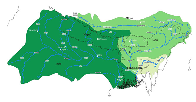
The governance of the Ganges and Brahmaputra river systems poses a complex challenge due to the interplay of their social, political, economic, cultural and ecological dimensions. The Ganges and Brahmaputra—the two major river systems of the Ganges-Brahmaputra-Meghna (GBM) basin—consist of a number of tributaries emerging from both the north and south aspects of the Himalaya and feeding the mainstreams. The annual run-off of 1150 billion cubic metres is the total outflow of the GBM basin draining into the Bay of Bengal. The international transboundary characteristic of the hydrological unit emerges from the basin that encompasses areas from Bangladesh, Bhutan (all), China, India, and Nepal (all).[13]Ganges and Brahmaputra, with their tributaries and distributaries, pass through boundaries of the various nations and the federal states, and have been subjects of intense disputes over sharing of lean flows.[14],[15]
Map 1: The Ganges-Brahmaputra-Meghna Basin
Source:Authors’ own
Table 1: Countries in the Ganges and the Brahmaputra sub-basins
Country
Ganges sub-basin
Brahmaputra sub-basin
Sub-Basin area (1000 km2)
Percentage of total area
Sub-Basin area (1000 km2)
Percentage of total area
China
33
3
293
50
Nepal
140
13
–
–
Bhutan
–
–
45
8
India
861
80
195
34
Bangladesh
46
4
47
8
Source:Rangachari and Verghese (2001)[16]
1.1 Ample Water, Ample Poverty
Traditional development policy in South Asia associates water availability with economic well-being.[17],[18]This has led to the development of large projects for supply augmentation and hydro-power in the basin. However, that has neither helped the cause of poverty alleviation, nor of food, energy, and water security.[19]Even today, the basin is home to some 176 million poor people.
Table 2: Water resource development and poverty in the GBM river system
Sub-basin
Total Renewable Water Resources (billion Cubic metre)
Per Capita water availability (cubic metre)
Poverty (million)
Water Withdrawals (billion cubic metres)
Water resources developed (%)
Surface Storage Potential (billion cubic metres)
Ganges
525
1039
135
266.8
44
94.35
Brahmaputra
586
17855
41
9.9
11
52.94
Source:Computed by authors fromvarious sources[20],[21],[22],[23]
The rapid expansion of human interventions in the water systems in India from the 1960s was motivated by concerns about food security. The rivers emerging from the Himalaya, in particular, those providing snow- and glacier-melt flows, became increasingly important in meeting the growing demands in the plains for irrigation in the early summer months. Yet, while food production has increased due to additional area brought under irrigation, there is a decline in growth rate of food production, and per capita food consumption has stagnated.[24],[25]
In the last few decades, interventions in the GBM basin have been made largely for energy security, and hundreds of hydro-power projects have been planned or built on the many tributaries to the Ganges and Brahmaputra. Such interventions were frequently based on old ideas and site selections made several decades earlier.[26],[27]Literature questioning the long-term economic viability and ecosystemic sustainability of such projects has emerged in the new millennium.[28],[29],[30]While the long-run costs of these hydropower projects far outweigh the potential benefits (as ecosystem and social costs are not featured in the cost-benefit matrix),[31]hydropower still remains an important option for achieving renewable energy goals in the region.[32]
1.2 About this paper
This paper examines how the challenges of governing the river basins in South Asia emerge from a fragmented and reductionist vision of basin management. This is taken up in the context of the two major river systems, the Ganges and the Brahmaputra, which are classified as “sub-basins”. The paper argues that the reductionist hydrology paradigm has resulted in ignoring vital information and knowledge gaps, aggravating the governance challenge.
2. Challenges of Water Governance
Reductionist hydrology often reveals itself as “arithmetic hydrology”[33]based on structural engineering and neoclassical economics that focus on short-term optimisation of a resource.[34]The governance challenges are visible in the conflicts that have taken various shapes: they occur at various scales of political boundaries (international and interstate), and sectoral ones (economic and the ecosystem). This section uses case studies to reinforce the need for a new paradigm for the governance of the Ganges and the Brahmaputra river systems.
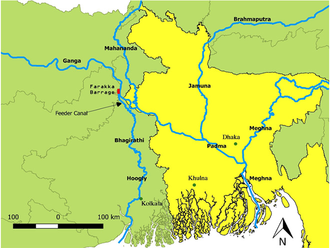
2.1 The Farakka Barrage
The Farakka Barrage was planned to enhance the flow of Bhagirathi-Hoogly by diverting the flow of the mainstream Ganges, and flush the sediments to resuscitate the Kolkata (then Calcutta) port. The Government of Pakistan objected to the project and, after 1971, the Government of Bangladesh did so, too. Downstream Bangladesh (east Pakistan prior to 1971) was concerned that the flow diversion would cause reduced flow of the mainstream in Bangladesh in the dry season, and have deleterious impact on agriculture and economy.[35],[36]For long, this created a perception that the less powerful downstream Bangladesh was receiving a poor share of the benefits from the trans-boundary waters.
There were two reasons why the barrage is often blamed for water scarcity and salinisation of the lower parts of the delta.[37]The first was about the feasibility of the sediment “flushing” hypothesis raised in Indian technocracy by the likes of Bhattacharya,[38]and India’s failure to recognise the downstream impacts of the project. The second was the misplaced assumption that the release of water stored behind the Farakka Barrage can cause flooding in Bangladesh.[39],[a]
Map 2: The Farakka Barrage and the Feeder Canal through Bhagirathi-Hoogly
Source:Authors’ own
The hydropolitical situation was saved when the two countries signed the 1996 Ganges Water Sharing Agreement, which provided a schedule of flows from the Farakka barrage during the dry season months from January to May. According to the treaty, India can draw up to 40,000 cusescs of flow if the availability exceeds 75,000 cusecs. If availability at Farakka falls below 70,000 cusecs, the flow will be divided equally between the two countries, while guaranteeing 35,000 cusecs to Bangladesh if the flow is in the range of 70,000-75,000 cusecs. Unfortunately, without consideration of the sediments, biodiversity, and the broader ecosystem concerns, the India-Bangladesh treaty of 1996 turned out to be merely an arithmetical exercise.[40],[41],[42]In the words of Hanasz[43]“…The … Treaty is a water sharing agreement in its most primitive sense: it is solely an arrangement for the volumetric allocation of river flow in the dry season. It does not concern benefit sharing, nor does it purport to be a comprehensive river sharing and management treaty.”
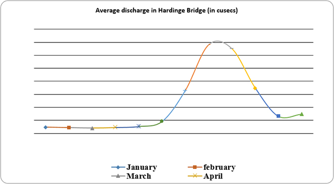
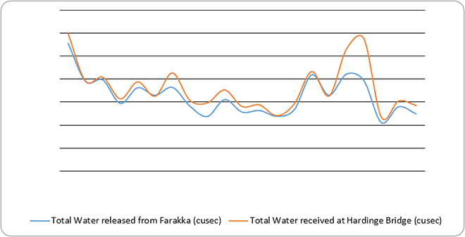
Fig. 1.
Source:Computed by authors from data by Joint Rivers Commission, Bangladesh and Bangladesh Water Development Board
In the dry seasons, the flows received at the Hardinge Bridge (the first measuring station on Ganges mainstream in Bangladesh) are generally higher than the ones released from Farakka (See Fig. 2). This is possible due to many factors, one being the additional flow of a tributary Mahananda, and also a possible aquifer flows moving up the surface.
Fig. 2: Dry season release from Farakka and flow in Hardinge Bridge from 1998-2018
Source:Computed by authors using data from JRC Bangladesh
The barrage is also the subject of domestic conflicts in India. In 2016, the government of Bihar in eastern India, blamed the barrage for causing floods in its territory in the upstream, and called for its removal.[44]The Central Water Commission refuted Bihar’s claim.[45],[b]
The frequent floodings in UP, Bihar, and West Bengal are not aberrations, contrary to the view widely held by policymakers, but integral components of the global ecohydrological cycle. The perception of floods being “unmixed bane” is a legacy of colonial-era engineering that failed to appreciate the role of floods in supporting the ecosystem.[c]
The removal of the Farakka Barrage will likely not solve the problem, but only escalate interstate conflicts. Indeed, the barrage has ameliorated the water problem during lean seasons in the downstream, in the densely populated areas of West Bengal, due to the better flows through the Bhagirathi-Hoogly channel. This has helped meet the urban water needs of the burgeoning Kolkata metropolis through resuscitatation the surface water flow in the channel, and may have also ensured groundwater recharge. Decommissioning the Farakka will negatively affect the population and ecosystem services in this part of the state.[46]
In 2026, the 30-year 1996 Ganges Water Sharing Agreement will come to an end and critical decisions need to be taken during that time on the mode of benefit sharing.
2.2 Interlinking of Rivers in India
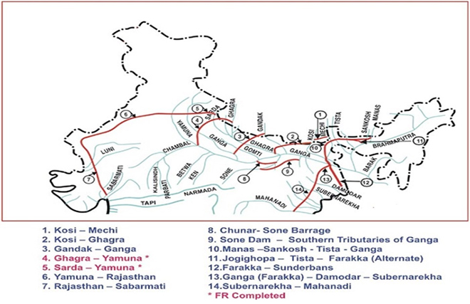
A proposal for diverting part of the flow of the Brahmaputra by linking its tributaries Manas, Sankosh and Teesta, with the Ganges (MSTG Link) is being planned as part of the larger Interlinking of rivers (ILR) project in India. The alternate proposal also exists in the form of the Jogighopa-Teesta-Farakka linkage that would transfer water from the Brahmaputra system to the Ganges upstream of the Farakka barrage. Both these transfers will have implications for the lean flow in Jamuna or the lower Brahmaputra floodplains in Bangladesh, as downstream agriculture and ecosystem will experience reduction in water availability. However, one may also argue that there remains the option of flood control during the high monsoon in the Jamuna floodplains with structures constructed in the Indian boundary, if technical feasibility is ensured and the downstream can successfully negotiate with upstream. Moreover, the reduction in dry season flow due to the diversion will lead to lowering of freshwater flow in the Brahmaputra delta, and will allow for saline water to take its place.[47]There is also the question of how sediment flow will be dealt with, as the Brahmaputra-Jamuna system has the highest sediment load of all river systems of the world.
Indeed, the idea of transferring water from the “surplus” basins to “deficit” basins—a classic example of “arithmetic hydrology”—has drawn criticisms from the perspective of ecological and economic impacts.[48]At the same time, it has triggered disputes between Indian states.[49]Assam, for example, has already raised questions against the MSTG project, as have NGOs and civil society groups in Bangladesh. If official negotiations do not precede the completion of the link canal, it may trigger further disputes between riparian nations.[50] It is apparent that an old and uninformed approach is guiding the conceptualisation of this massive project that will intervene into the Himalayan river systems of Ganges and Brahmaputra.
Map 3: Proposed Himalayan Links in the ILR Project
Source:India Water Portal and National Water Development Authority
2.3 The Sundarbans Delta
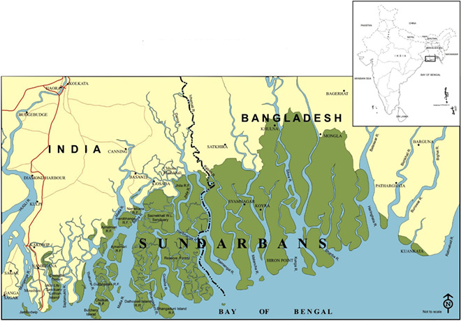
The Sundarbans is the largest single area of tidal halophytic mangrove forest in the world and is transboundary, straddling southern Bangladesh and a small part in the Indian state of West Bengal. The complex ecosystem spreads over 26,000 sq km, with 9,630 sq km in India. Home to 10 million people in both India and Bangladesh, the Sundarbans is also one of the most poverty-stricken regions of the world. The deep-rooted ecosystems-livelihoods linkage can be witnessed from the heavy reliance of the population on the various provisioning services of the ecosystem, that include fishery, honey collection, shrimp larva farming, crab collection, and agriculture.
Studies have blamed the Farakka barrage for drying up the Delta and causing salinity ingression.[51],[52]While the Farakka barrage has allegedly inhibited soil formation of the delta as explained earlier, sea-level rise at the rates of 8mm-12mm annually has resulted in significant land-loss without simultaneous soil resuscitation mechanism.[53],[54]In the Indian part, saline water ingression has proved detrimental for agriculture, and there are talks on reviving the salt-tolerant variety of paddy that was lost during the Green Revolution of the 1960s.[55]Again, though there is a decline in the overall frequency of storms, depressions, cyclones and surges, the proportion of higher intensity events appears to be increasing, possibly as a result of rising sea surface temperatures.[56]In view of this, two papers by Danda et al[57],[58]have highlighted the need for managed and strategic retreat from the climatically vulnerable zone and ecosystem regeneration in the Indian Sundarbans Delta, and argue that such an adaptation is economically more beneficial than the business-as-usual scenario of non-adaptation. Such an exercise is missing for the entire Sundarbans.
Map 4: Sundarbans Delta
Both the Indian and Bangladeshi governments recognise that the Sundarbans need a holistic and cooperative approach. This led to the signing of the Memorandum of Understanding (MoU) onConservation of the Sundarban in September 2011.[d]The MoU, however, is confined to the conservation of the forest, and lacks any reference to the developmental issues plaguing the region. Though the agreement recognises the importance of ecosystem services, it reflects the lack of a holistic approach to development with a view to the integrity of the ecosystem internalising the threats posed by global warming and climate change.
2.4 China-India relations on the Brahmaputra
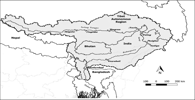
The Brahmaputra river system has emerged as a contentious issue in China-India hydropolitical relations, driven more by popular perceptions based on unconfirmed data.[59]The popular perception in India about the “Chinese hand” in various matters in the Brahmaputra began with China’s commissioning of the Zangmu hydropower project in 2014 on the Yarlung Tsangpo downstream of Yangcun in Tibet. Over time, media reports on China’s plan for a 1,000-km-long tunnel to divert the flows of the river, blackening of the flow of Siang in Arunachal Pradesh in 2017, and reporting of similar events accentuated this perception. China has thus been projected as an upstream “hydro-hegemon” with plans for interventions in the Brahmaputra, much to the detriment of downstream nations.[60]Such perceptions are being contested by hydro-meteorological data that confirms that the precipitation in the river system in the north aspect of the Himalaya in Tibet area is quite small, resulting in low flows in the upper reaches of Brahmaputra.[61],[62],[63]Therefore, diversions in those parts are not going to have significant impact on the flow in the downstream India and Bangladesh, as the Brahmaputra formed near Sadiya is substantially fed by various tributaries contributing to more than 85-90 percent of the run-off in the downstream.[64]
As such, a large component of the total annual flow of Brahmaputra is generated in the south aspect of the Himalaya in India by numerous tributaries—from Buri Dihing in the east to Teesta in the west. The total annual outflow of the Yarlung from China is estimated at 31 BCM (billion m3) while the annual flow of Brahmaputra at Bahadurabad, the gauging station near the end of the sub-basin in Bangladesh, is about 606 BCM.[65]This negates the widely held view that the run-off must be proportional to the length of the river system, as 57 percent of the length of the river system is in Tibet.
The disproportionate precipitation is another important issue. There is an existing MOU between China and India,[e]first signed in 2002, on the sharing of flow data on the Yarlung Tsangpo. This is for facilitating advance warning for floods during the summer monsoon period. The importance of the early warning lies in the fact that floods in the Brahmaputra have been responsible for substantial losses in life and property in Assam.[66]The MoU also has the provision of data sharing if the water level is close to the warning level during the non-flood season. In return, India is required to share information regarding data utilisation in flood forecasting and mitigation. This exchange works in conjunction with the establishment of an institutional mechanism, India-China Expert Level Mechanism (ELM) on Trans-border Rivers.
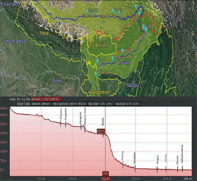
Map 5: Yarlung Tsangpo / Brahmaputra with key monitoring stations
Source:Ghosh et al (2019)[67]
The MoU is flawed, considering its objective of early warning, and shows the lack of hydro-meteorological understanding of the river system. The Brahmaputra is fed by both rainfall, and snow and glacial melts. The normalised melt index[f]of the Brahmaputra is in the low range of 0.15-0.2—this means that snow and glacial melt, the main source of run-off in the Tibetan region, contribute little to the total flow.[68]Map 6 shows the altitude for a few locations on the Yalung Tsangpo/Siang and Brahmaputra.
Map 6: Altitude for a few locations on the Yalung Tsangpo/Siang and Brahmaputra
Source:Authors’ own
The precipitation varies across the Brahmaputra sub-basin owing to factors of climate, altitude, temperature, pressure, latitude, and orography, and variable interactive impacts of different prevailing winds. As discussed earlier, the Tibetan component of the basin, i.e. the longer stretch of the Yarlung, being located on the north aspect of the Himalaya, receives less rainfall than the south aspect, due to the Himalayan orogeny and its influence on the movement of moisture-laden air currents. Precipitation in the southeastern part of Tibet occurs primarily during the summer monsoon months of July and August.[69]While the overall annual precipitation in the trans-Himalaya averages 300 mm, the annual average precipitation (that includes mainly rainfall) reaches 4,500 mm as the flow moves to the south aspect of the Himalaya, by transcending the crestline.[70]The foothills are frequently fed by precipitation of unpredictable magnitude within a short period of time, which can cause massive floods.[71]
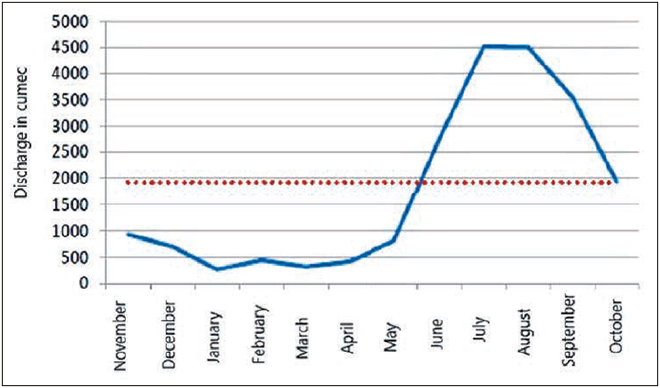
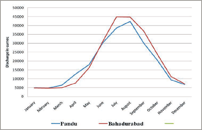
While the Brahmaputra valley in Assam receives much higher average annual rainfall, the peak flows in the valley are substantially fed by the precipitation from the southwest monsoon. Using meteorological data from the World Weather Online from 2009 to 2018, Ghosh et al (2019)[72]found that the northern aspects of the Himalaya receive an annual precipitation equivalent to 10-15 percent of what is received in the southern aspect of the Himalaya—namely, Guwahati (India), and in Bahadurabad (Bangladesh). During the south-west monsoon, this percentage ranges between five and 10. This also gets reflected in the flow figures: the peak flows at Tsela Dzong and Nuxia in Tibet are 5,000 and 6,000 cumecs, respectively[73],[74], while the peak flow at Pandu (Guwahati) is 60,000 cumecs.[75]. The lean season flow in Nuxia is at 500 cumecs,[76]while the lean flow at Bahadurabad in Bangladesh is about 5,000 cumecs (See Figure 3).
Figure 3: Relative Hydrographs of discharge at north and south aspects
(A) Nuxia (Tibet)
(B) Pandu (Guwahati) and Bahadurabad
Source:Friedrich-Schiller University (2008)[77]and Ghosh (2015)[78]
This is due to the intense monsoon precipitation on the south aspect of the Himalaya. While Nuxia receives around 405 mm of rainfall during monsoon,[79]as one reaches the southern aspect, the annual rainfall in Pasighat on Siang touches 4,500 mm. The large amounts of flow contributions of the tributaries to Brahmaputra in the Indian boundary also enhance the flow of the mainstream substantially.[80],[81]
Table 3: Discharge of the Brahmaputra system at various sites
Stretch
Observation Site
Mean Annual Discharge (in BCM)
Source of Data
Yarlung Tsangpo
Nuxia
31.2ato 60.57b
a. Jiang et. al. (2015) b. Zhang et al. (2013)
Yarlung Tsangpo
Point leaving China
135.9
Huang et al. (2007)
Siang
Pasighat
185.1
Sharma (2003)
Brahmaputra
Pandu
526.1
WAPCOS (1993)
Jamuna
Bahadurabad
605.49
Jiang et. al. (2015)
Source:Ghosh et al (2019)[82]
There is enough evidence that the suspended sediment load of the Brahmaputra is proportional to the flow across the various stretches of the basin.[83]This needs to be attributed to the high slope and high rainfall in north-west Himalaya, as shown in Map 6 and will be discussed later in this paper.
2.4.1 Data Sharing on Yarlung Tsangpo/Brahmaputra for Advanced Flood Warning
Under the direct exchange mechanism of the MOU, China provides India with daily data on water levels, discharge, and rainfall over three stations on Yarlung.[g]Given the data on hydro-meteorological variation of the Brahmaputra, it is clear that between Nuxia in Tibet and Tuting where the river enters India from China, there are many possibilities of heavy rainfall causing floods in downstream Brahmaputra. Therefore, it is unlikely that the present data-sharing mode can help in early warning for India. This becomes clearer with a closer inspection of Map 5, which shows that Nugesha, Yangcun and further downstream Nuxia are located in the rain-shadow area, with annual average precipitation in the range of 0-500 mm. An important left-bank tributary – Parlung Tsangpo joins the Yarlung further downstream of Nuxia, which increases the flow downstream of Nuxia. The stream-flow witnesses compounded impact further downstream of the confluence of the Yarlung and Parlung, with substantial increase in precipitation. This is corroborated by the discharge data (in Table 2) which shows that the discharge of Yarlung increases by more than twice as the river crosses Nuxia, undertakes a ‘great bend’ around the peak Namchi Barwa and after some distance enters India.
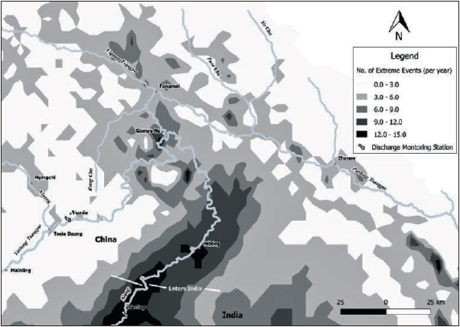
As far as India is concerned, between Nuxia, the last hydrological station from which India receives flood-period data, and Tuting, the first hydrological station within Indian territory, no data is made available while the river Siang travels 320 kms through a rain-rich area.[84]Indeed, this region is hazard-prone, with 10 or more annual occurrences of hazardous events, with the hazard risk increasing as the flow moves further downstream (Map 7). The entire region experiences at least three extreme events throughout the year.[85]
This raises concerns with the efficacy of the choice of stations for data exchange for early flood warning, thereby making the downstream districts of Arunachal and Assam vulnerable to floods. By virtue of its location at the foothills of the Himalaya and the abrupt decline in the river’s gradient, East Siang becomes a potentially vulnerable zone. This can also seriously affect the neighbouring districts of Dhemaji and Dibrugarh in Assam, with the travel time of flood wave from Pasighat to Dibrugarh being only 12 hours. The origin of the problem lies either with lack of information, or with lack of analysis of the available information.
Furthermore, the floods in the Indian boundary especially in the Assam floodplains of the Brahmaputra should largely be attributed to the steep slope after Tuting and Pasighat (See Fig. 8), as well as the large volume generated afterwards at the confluence of Dihang, Dibang and Luhit, land-use change in floodplains and raising of river beds[86]due to sediment deposition and earthquakes.[87]The existing early warning can hardly play a role in predicting it.
Map 7: Distribution of Extreme Events at the Great Bend
Source:Ghosh et al 2019[88]
2.5 Bangladesh-India issues over Teesta
The Teesta is a tributary of the Brahmaputra or Jamuna in Bangladesh, originating from the Pahunri (or Teesta Kangse) glacier above 7,068 metres (23,189 ft), and flowing southward through Sikkim and West Bengal in India, and crosses over to Bangladesh.[h]Historically, Teesta has been an issue of contention between Bangladesh and India over sharing of water for dry season irrigation (December- May). There have been a host of talks between the nations, and an ad-hoc agreement of 1983 allocated 39 percent to India, 36 percent to Bangladesh, while leaving the remaining unallocated. The treaty, however, lapsed within two years. In 2011, there was a renewed attempt to ink an agreement on the basis of the Joint Rivers’ Commission 1984 recommendations that recommended allotting 42.5 percent to India and 37.5 percent to Bangladesh, but this could not be implemented due to vehement objection from West Bengal.
Bangladesh has been complaining that substantially low flow has affected their farmers whose standing paddy crops are withering away; fisherfolk are also facing loss of livelihoods. The West Bengal CM’s objection to share water with Bangladesh is based on the premise that there is not adequate water in the Teesta to be shared. This is vindicated by excerpts[89]of a recently prepared internal report on the Teesta prepared by an Expert Committee of West Bengal Government (see Basu 2017): “According to a rough calculation, such … scale of irrigation for boro crop (dry season paddy) will require around 1600 cumec … of water; while through much of the dry period the river hardly has 100 cumec of water, i.e. one sixteenth of total water requirement in [the] two countries.”[90]
This measure varies across stations and cannot be uniform all across. How reliable is the data? There is hardly a way to verify the veracity of this claim due to non-availability of classified flow data in the public domain.[91] Further, if this figure is to be believed, the question that arises is where the remaining 94 percent of the water has gone. In some opinion pieces, the Teesta Barrage Project (TBP) at Gajoldoba in the Jalpaiguri district of West Bengal is being blamed for the disappearing waters further downstream.[92]Conceived as a multi-purpose project in the aftermath of the massive floods in Jalpaiguri in 1968, the TBP was planned for flood control, hydropower and irrigation in north Bengal. It is proclaimed that though the TBP has contributed to flood control to an extent, there has been less success towards increasing the areas under irrigation in the lower command area and the flow in the downstream nation of Bangladesh has diminished. It has been hypothesised that water diversion through the Teesta-Mahananda irrigation canal is responsible for the flow reduction. However, as observed by these authors during a field visit in June 2017, there are as many as 30 hydropower projects in the stretch of the Teesta (operating and planned). Despite being claimed as run-of-the-river projects, the lack of flow during the dry season forces development of “pondages” or storage mechanisms in the upstream of these projects, and requires at least 12-20 hours of storage daily during dry season, before the turbines could run.
With successive projects at short distances from each other, this substantially fragments the river, dries up the downstream, alters the short-term hydrograph, and proves detrimental for the biodiversity and critical ecosystem services like water provisioning and fisheries. The biggest diversion takes place in the TBP through the Teesta-Mahananda channel, allegedly for the burgeoning cities of Siliguri and Jalpaiguri in north Bengal.
Both the hydropower projects and the multipurpose TBP reflect short-term thinking and reductionist hydrology. The important role of storage for allocation during the dry season and the concerns of sedimentation were not taken into account. Flood control was thought of from the perspective of channelling “surplus” water through alternate link canals.
Despite the fact that the conflict of today centres around agricultural use of water, especially for irrigatedboroor dry season paddy, which is the highly water-consuming crop with a crop-water requirement of around 1800-2800 mm, governments do not seem to have attempted to counsel producers to diversify to other less water-consuming crops over the last 30 years, ever since the talks on Teesta emerged between the two nations.[93]In India in 2018, there was an attempt at the national level to promote less water-consuming Ragi by increasing its government support and procurement prices at a higher rate than paddy.[94]But the initiative is too recent to have any significant impact thus far. Rather, Bangladesh’s penchant for dry season paddy cultivation has been further facilitated by development of irrigation facilities through hydrological interventions on the river flow regimes, leading to loss of river health, downstream flows, and ecosystem functions and services. A marginal benefit based approach of water allocation was presented by Mullick et al (2013),[95]but that could hardly accommodate the ecosystem variables. Rather, literature has accommodated the human water demand and ecosystem water needs in terms of a conflictual zero-sum game.[96]
3. Knowledge Gaps
The information and knowledge gaps on the Ganges and Brahmaputra owe largely to the withholding of data by the government (especially India). More importantly, policymakers have proved lacking in understanding the need for a more holistic, basin-level, ecosystemic approach to water governance. In the case of the Ganges Water Treaty of 1996, for instance, the only variable considered was the water flow; the associated sediment, biodiversity, and the ecosystem processes and serviceshave been neglected. Similar are the cases of dealing with river interlinking, hydropolitics of the Brahmaputra mainstream and the Teesta river, and the drying up of the Sundarbans delta. In all these cases, knowledge base is inadequate, constrained as it is by reductionist hydrology. The knowledge gaps can be categorised in the following manner.
a)Institutional void: The challenge of water governance needs to be seen from the perspective of how water is viewed in India. According to the Indian Constitution, Water is a State subject. However, the role given to the Union government with regards to inter-State rivers and river valleys is significant, as seen in the use of the provisions of Entry 20 in the Concurrent List. This Entry titled, “Economic and Social Planning”, provides that major and medium irrigation, hydropower, flood control and multipurpose projects are required to obtain a clearance from the Union government. These clearences are sought under the Forest Conservation Act of 1980 with its subsequent amendments (the last one being in 2004) and the Environment Protection Act of 1986. In the words of Ramaswamy Iyer,[97]“… It could plausibly be argued that even under the present dispensation the Centre has significant responsibilities in relation to water, and that it has not in fact discharged those responsibilities adequately.”
Through the 73rd and the 74th amendments of the Indian Constitution, power was rendered to the local government at the village and city levels to take responsibilities for drinking water, water management, watershed development, and sanitation. The Draft National Framework Water Bill 2016 also recognises the importance of local institutions in water governance.
However, the decentralisation of water governance—with the role of the Union government being confined to clearances and inter-state water disputes—have not helped the cause of improved water governance and conflict resolution either. Rather, there is an institutional void at the basin level created by this federal structure that has led to the fragmentation of water governance across the river basin, as states have begun defining their rights over water in their own ways.[98]This has only escalated conflicts at various levels, as has been described in the case of Bihar and West Bengal on the Farakka issue, and the one over Teesta with divergent views of the Centre and the state of West Bengal. In other words, lack of acknowledgement of the need to consider the river basin as a unit of governance in the statutes have led to water being subjected to “conflictual federalism[i]”.
b)Gaps in ecohydrological knowledge on surface water systems:The lack of knowledge of ecohydrological processes is more acute for the Brahmaputra. Most of the research on the Brahmaputra system has been confined to the Assam floodplains. Claudia Sadoff and her colleagues[99]attempted to develop a set of hydrological and economic models for the Ganges system, “… using modern data sources and modelling techniques to assess the impact of existing and potential new hydraulic structures on flooding, hydropower, low flows, water quality and irrigation supplies at the basin scale.” The study’s findings are remarkable:[j]
Upstream water storage in Nepal cannot help in flood regulation, though could potentially double low flows in the dry months;
There is potential for hydropower development and trade subject to rigorous project level assessment with particular attention to sediment and seismic risks;
Climate change posits significant uncertainties persist, and the data quality needs to be improved.
On the Brahmaputra system, as stated earlier in this paper, comprehensive basin-level analysis is still missing, with a few exceptions.[100]However, as has been highlighted here, lack of analysis on the Brahmaputra that is based on actual hydro-meteorological data has created misconceptions amongst the public in the co-riparian nations. On the other hand, attempts to delineate and understand the ecosystem processes and services associated with the flow regimes seem to be half-hearted in the formal water governance regime in South Asia.[101] One example is the ineffective way that environmental flows are being delineated across South Asia: as merely a percentage of total flows, as if a single number is sufficient for sustainability of a basin ecosystem. This, being a clear deviation from the basic principles of Brisbane Declaration and the negotiated approaches, has come under severe academic criticism.[102],[103]
c)Knowledge gaps in flood management:Traditional engineering views high-flow inundations during monsoons as “flood disasters”. As such, response to these events is focused on relief, rather than being proactive and long-term.[104]The damages have aggravated with extensive changes in land-use and land-cover due to human settlements in the floodplains. Kapuria and Modak (2019) have attempted toprovide a more holistic understanding of floods by incorporating the hydro-meteorological, hydro-geomorphological, ecological and socio-economic dimensions of monsoon floods in the Ganges river system. It is true that inadequate and technocratic understanding of floods has inhibited acknowledgement of the geomorphic, hydrologic, hydraulic and biological processes of rivers in flood disaster mitigation initiatives.[105],[106]There has also been an emphasis on the need for better understanding of seismic sciences and fluvial geomorphogy for managing floods.[107]Unfortunately, there has been little progress in the development of seismicity prediction and the associated expected changes in Himalayan river basin ecosystem.
d)Gaps in knowledge of social dimensions of water systems use and local governance:The advent of European engineering for water managed created a “metabolic rift” between humans and nature, resulting in the loss of indigenous tradition-based water management regimes amidst structural interventions. Such millennium-old community-based traditions varied across the Ganges and Brahmaputra river systems, on the basis of physiographic characteristics of the basin ecosystem as well as resource endowments. In recent years, non-government initiatives to resuscitate such traditions have emerged, filling the gap in governmental efforts despite official documents.[108]Further, although water governance in the Hindu Kush Himalaya (HKH) is characterised by hybrid formal-informal regimes, synergy and support between the governmental institutions and informal institutions are often lacking.
e)Gender inequity:There is a lack of understanding on the relationship between gender and water. This dimension needs a special focus from the very perspectives of equity concerns of river basin governance. A recent ICIMOD report suggests that for the Himalayan river systems, gender inequity translates into inequitable water access.[109]Unfortunately, while there is anecdotal evidence of piecemeal field research, the relationship at the basin scale needs to be explored further. This knowledge gap also creates weaknesses in the understanding of how social institutions play a role in the access of ecosystem services associated with flow regimes of the two river systems.
f)Knowledge gap on diverse demands andrequirements of water over space and time: Understanding and prioritising diverse water demands, while keeping in view the integrity of the natural ecosystem, is an important hallmark of IWRM. In the scenario of increasing demand for water, water conflicts arise from lack of understanding of the broader spatial and temporal dimensions that have taken different forms than what has been traditionally believed. At the spatial level, the conflict is between two broad sectors: the human economy versus the natural ecosystem. The rise in human economic demand (industry, agriculture, household, energy) and intrusion over hydrological flows have affected the natural ecosystem. At a temporal level, the conflict is between the short-run myopic economic needs, and long-run sustainability concerns. It is short-term economic gains that often override the long-run impacts on livelihoods that are dependent on the ecosystem services which get impaired due to reduced water and sediment flows. Therefore, sound knowledge of the diverse demands including that of the ecosystems is of utmost importance for more informed decision on interventions, and ex-ante and ex-post assessments. This becomes even more pronounced when the national governments in the basin are committed towards the fulfilment of the Sustainable Development Goals (SDGs).
g)Knowledge gaps on the Himalayan components: Lack of knowledge on the Himalayan ecosystem has inhibited objective and professional assessments of large projects, thereby casting questions on their viability. These gaps are identified under the following heads:[110]
the mechanism of the generation and draining out of flood waters in the Himalayan foothills and floodplains;
the dynamics of the generation, transportation and deposition of sediments all along the course of the Himalayan rivers;
the nature of seismic risks associated with high dams in the Himalaya;
the impacts of structural interventions in the Himalayan rivers, like dams, barrages, and embankments; and
the impact of the four points above on the economic feasibility of water development projects.
h)Gaps in knowledge in the relation between water and food security:Food security in large parts of South Asia is perceived as a positive function of water availability. Recent literature, however, refutes such a relation.[111],[112]The ecosystemic approach and definition of food security is neither understood nor acknowledged and there hardly exists any knowledge created in South Asia in this domain.[113]The importance of floods and the ecosystem services of sediments in making the Gangetic floodplains the “rice bowl” of the region are hardly recognised.
i)Lack of detailed, public hydrological data:Sensitive flow data have notbeen made available in the public domain by the national governments, especially India. This restricts independent assessments of hydrological projects and livelihoods issues on the basin, and has created a void in knowledge on some of the important transboundary issues like floods,[114]droughts,[115],[116]and ecosystem services.[117]This also creates wrong perceptions, as has been the case for China-India relations over Brahmaputra, and for Bangladesh and India relations, over Ganges. Since the Joint Rivers Commission began placing data on Farakka and Hardinge Bridge in the public domain, it has been realised that Hardinge Bridge in Bangladesh receives more water than what is released from Farakka, as the Mahananda river joins the mainstream Ganges upstream of the measuring station.
j)The threat point of Climate Change:Certain estimates warn against the serious impact of climate change on the Brahmaputra, and to a lesser extent, on the Ganges.[118]Climate change will also entail a consistent increase in streamflow in large scales at the upper reaches of both the rivers.[119]There is evidence on the serious impacts that the deviation of the seasonality of the monsoon can create on water availability in the region. The Intergovernmental Panel on Climate Change (IPCC) third assessment report (IPCC-TAR) has indicated the possibility of greater frequency and intensity of extreme events related to water.[120]The impacts of global climate change on precipitation, stream flow and water availability in the Himalayan systems have been major areas of global research.[121]
Preliminary observations indicate that in addition to the reduction in the snow and ice cover in the Himalaya, water scarcity and extreme events in the region may be accentuated, thereby posing a threat on the environmental security further downstream in the context of the transboundary water relations between India and Bangladesh.[122]Forecasts also suggest that changes in climate will exacerbate the existing variability.[123]In the Ganges basin, climate change is expected to increase temperatures, resulting in the retreat of glaciers; increase variability in precipitation, resulting in increased magnitude and frequency of droughts and floods; and lead to sea-level rise.[124]
A 2017 paper in the journalClimatic Change[125]finds that the frequency and magnitude of floods in the Brahmaputra are likely to intensify in the future. On the other hand, both the frequency and intensity of hydrological droughts are projected to diminish. Further, the average timing of both the events is projected to shift to an earlier period as compared to the present hydrological regime.
Even as it is anticipated that climate change will influence the GBM basin, there is uncertainty about the possible impacts on food production and other ecosystem services. Research has yet to be conducted on the potential impacts of climate change on the critical ecosystems-livelihood linkages. It is possible that with the alterations in ecosystems services caused by changes in climate, livelihood processes might get negatively affected, and as a result newer modes of adaptation will emerge.
4. The Need for Holistic River Governance
The primary tenet of integrated river basin governance is that the river basin should be considered as the spatial unit of riverine management, and the naturally functioning river basin ecosystems, including any wetlands and groundwater, are integral components of the river system. Therefore, the maintenance of ecosystem functions and services is a pillar of basin governance.[126],[127]
In South Asia, even as policy documents have acknowledged ecosystem issues, they did so without a proper understanding of such concerns. For example, the notion of “environmental flows” has been used without understanding their ecohydrological processes.[128]India’s National Water Policy 2012, for one, states: “…A portion of river flows should be kept aside to meet ecological needs ensuring that the low and high flow releases are proportional to the natural flow regime, including base flow contribution in the low flow season through regulated ground water use.”[129]More recent government documents, including the National Framework Water Bill 2016 and the 2016 Report, A 21st Century Institutional Architecture for India’s Water Reforms,make an effort to integrate the various issues.
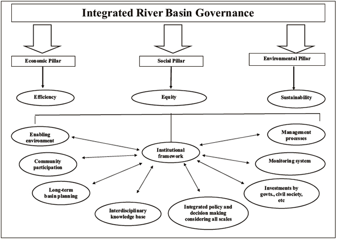
A systems approach to river basin management is an improved alternative, often referred to in the economic principle of “Pareto Improvement”.[130]River basins are sensitive over space and time, and any single intervention has implications for the system as a whole. Activity in a part of the basin (e.g. disposal of waste water or deforestation) will have impacts downstream. While today’s best practices in water resources planning integrate quantity and quality management for both groundwater and surface water, there is a need to understand the impact of interventions or policies on both the natural environment and the resident population of a basin. This is best done in a participatory manner that involves all stakeholdersand balances development needs and conservation goals—or what is known as integrated river basin governance (IRBG).[131](See Fig. 4)[132]
The following are the pillars of IRBG, as conceptualised in Bandyopadhyay et al (2016):[133]
Incorporating community and stakeholder participation into the planning and management processes.
Drafting a long-term river basin vision, through the process of agreement among all stakeholders: There should also be an integrated natural resource policy agenda and clear financing and budgeting systems for the range of basin-wide activities.
An integrated approach toward policymaking, decision-making, and cost-sharing across various sectors including industry, agriculture, urban development, navigation, ecosystems, taking into consideration the poverty reduction strategies.
Decision-making at a macro river-basin-scale should also take into consideration concerns at the sub-basin or local levels.
There needs to be adequate investment and cost-sharing by all relevant stakeholders in the system, thereby making them more responsible for the success of such a system.
A comprehensive foundation of knowledge of the river basin and the natural and socio-economic forces that influence it: A prerequisite is adequate knowledge of the conditions and behaviours of the social-ecological system of the basin.
A monitoring and auditing process to openly assess if the basin-wide institutional arrangements are achieving the goals and objectives set by governments.
Fig. 4: A Framework for Integrated River Basin Governance
Source:Ghosh and Bandyopadhyay[134]
4.1 The New emerging economics of water
The new emerging economics of water—which is based on heterodox ecological economic frameworks—should be brought into the integrated basin governance paradigm. In the past two decades, research on the ecosystem services of water and their economic implications has expanded. The Millennium Ecosystem Assessment (MA)[135]classified ecosystem services—widely used by humans—into four categories: provisioning services (such as the provisioning of food and water); regulating services (such as the control of climate and disease); cultural services (such as spiritual and recreational benefits); and supporting services for biodiversity. Monetary values of ecosystem services, though approximate yet indicative, are useful for policymaking and advocacy.[136]
The ecological economics of water looks at human society as an integral component of the broader social-ecological system, unlike neoclassical environmental and resource economics.[k]Ecological economics recognises that water provides numerous services to human society: it provides provisioning services in the form of agricultural crops, sea-food, aquatic species and plants; it provides supporting service to terrestrial ecosystem including forests that play important regulating functions; and it plays important roles in cultural services.
While a few of these services are visible and documented, there is a range of ecosystem services that have yet to be understood by ecological sciences. On the other hand, there is no dearth of literature in ecological economics that deals with institutions.[137]This aspect tries to understand the working of institutions that can help in management of water, keeping in view its integration with the broader socio-eco-hydrological cycle.
4.1.1 Opportunities and Challenges of Inland Waterways through Ganges and Brahmaputra
India’s National Waterways Act 2016 has given an impression of creating opportunities for riparian nations towards mutual benefit by creating provisions for inland water trade between nations. However, the situation in the Ganges and Brahmaputra is has been historically more complex. National Waterway (NW) 1 through the Bhagirathi-Hooghly system might face the problem of inadequate flow during dry season for heavy vessels. However, NW 2 which entails parts of the Brahmaputra mainstream, with a length of 891 km between the Bangladesh border near Dhubri and Sadiya in Assam, presents an opportunity for transboundary cooperation through waterways connectivity. While the protocol agreement between Bangladesh and India remains a stable framework for transit and trade, Bangladesh cannot be expected to develop inland water trade with Nepal throughout the year, as all other connecting waterways do not have sufficient navigability during the lean seasons, especially for heavy vessels. Inland waterways can be a feasible option for cooperation during monsoon and/ or post-monsoon seasons. At the same time, the ecosystemic impacts of having too many cargo vessels need to be considered in the holistic cost-benefit matrix before such an idea can be implemented at an international, transboundary level. This requires the application of the heterodox ecological economic framework discussed earlier in this study.
4.2. Combining perspectives for a trans-disciplinary knowledge base
A holistic management regime, embedded in the framework of IRBG and incorporating principles of ecological economics, is key to addressing issues of governance in the Ganges and Brahmaputra. Non-traditional economic thinking must drive the new holistic engineering by combining engineering with ecological knowledge and social concerns. This can be achieved through the trans-disciplinary framework of IRBG.
Hydro-diplomacy in the Ganges and the Brahmaputra river basins must evolve with the disciplines of new economics and holistic engineering.[138]Three concerns need to be integrated in the framework of river basin policy and governance of the Ganges and Brahmaputra.
a)Understanding the Ecosystem service–Livelihood linkage:The river basin should be viewed as a collection of productive ecosystems that affect livelihoods further downstream. While upstream diversions help agriculture, there is a consequent decline in the downstream fishing economy along the river, as well as enhanced salinity ingress affecting downstream economies. Research on the economic role of ecosystem services has found that in many countries, the allocation of water has become a highly crucial issue related to livelihoods.[139],[140]Further, the importance of sediments needs to be understood in a holistic framework of fluvial geomorphology and biodiversity—an element that has eluded policymakers so far. Even floods in the Brahmaputra-Jamuna floodplains need to be understood through a holistic ecological engineering knowledge.
b)Valuation of Water:To complement the ecological perspective, a fundamental rethinking is underway with the internalisation of important perspectives of ecological economics, which, more importantly entails identification of economic values with ecosystem processes. Such valuation exercises are often conducted with offering a range of values (which, by themselves, are approximations). The important aspect of such valuation exercises is their usefulness in providing means to internalise factors that need to be considered in the traditional assessment of river projects.[141]
c)The Institutional Perspective:There is scant research on the institutional aspects of river systems governance over the Ganges-Brahmaputra-Meghna basin. The lack of comprehensive legal and institutional frameworks has also been pointed out by scholars.[142],[143]Ben Crow and Nirvikar Singh[144]have highlighted the need for extending bilateral exchange to multilateral exchange, as well as expanding negotiations from conventional diplomacy to incorporate private economic actors. At the same time, the ways in which property rights over water are viewed must be redefined. As stated earlier, “conflictual federalism” in water governance has emerged due to water being a State subject in the Indian Constitution, and states have their own definitions of ‘rights’. The contending doctrines of History (or prior appropriation), and Harmon (right belongs to the one who has the water falling on his roof) have led to interstate conflicts in India, with different states in the basin at various levels and sectors using their own definitions of ‘property rights’. It needs to be seen whether peaceful modes of negotiations for defining property rights as defined by the Hobbesian doctrine[l]is a better mode, or an autonomous powerful river basin organisation can help the process of resolution.
4.3 Impediments to an integrated approach
The need for a holistic mode of water systems governance has been reflected in various new policy formulations in different parts of the world, like the European Union’sWater Framework Directiveadopted in 2000. A key issue impeding effective water governance in South Asia is the inadequate capacity to implement processes of IRBG at various levels. A dedicated capacity building programme to build a cadre of resource persons who could plan and implement integrated, collaborative actions at watershed, sub-basin, and basin levels is strongly influenced by the present institutions that have emerged as vanguards of reductionist hydrology.[145]The Mihir Shah-led Committee Report of 2016, titledA 21st Century Institutional Architecture for India’s Water Reforms,talked of laying down the blueprint to build such a multi-disciplinary human resource and offered a platform to facilitate knowledge sharing across basin communities and organisations. Some scholars[146],[147],[148]have also emphasised on this.
The 2016 committee report recommended the dissolution of the nodal water agency of India—the Central Water Commission and the Central Ground Water Board—and the creation of a more holistic National Water Commission. The proposal has met with objections, especially from advocates of traditional water engineering.[149]To this day, river basin organisations created to resolve domestic water conflicts in India are dominated by engineers from the “water technocracy”,[150]who seek to reinforce reductionism.[151],[152]
Further, water technocracies and bureaucracies continue to “classify” data especially on international transboundary flows,inhibiting independent analyses on transboundary river basins.[153]The very scare of water being an instrument of securitisation has been responsible for the mistrust between nations. On the other hand, there is ample evidence across the world that data made available in public domains have engendered independent research and have helped the process of water governance.[154]
5. Conclusion
This paper has made a case for addressing the governance challenges in the trans-boundary water systems of the Ganges and the Brahmaputra by moving away from “reductionist hydrology” and using the frameworks of “holistic eco-hydrology”. The existing fragmented approach to governance of the two river systems based on narrow and short-term economic ambitions, along with a half-baked approach to hydro-diplomacy without consideration of hydrological realities, have posed threats to environmental security.
The shift from a state of distrust and suspicion, to one of trust and cooperation between the various national-level and sub-national players, can be enabled by a better understanding of an ecosystem-based approach to governance. This requires pushing data into the public domain and nurturing independent anlaysis and information dissemination.[155]This will require an institutional mechanism akin to the trans-national OGLOBS (Organization for Governance of the Lower Brahmaputra Sub-basin), as proposed by these authors in an earlier paper.[156]
Further, there is a need for inclusiveness of diverse disciplines for conducting research. The complicated challenges posed by a “dying delta” and the “raging flood” need better understanding of ecosystem processes, functions, and services. Only with clear recognitions of the ecosystem-based delineations of integrated river systems governance that concerns itself with human well-being and environmental security, can India and Bangladesh address the diverse challenges in governing the Ganges and the Brahmaputra river systems.
Endnotes
[a]The barrage cannot store any substantial quantity of water so as to create significant floods in Bangladesh.
[b]The call for the removal of Farakka is based on the backwater effect hypothesis—the sedimentation and consequent cascading of the sediments in the upstream of the barrage. The water deposits the suspended sediments, and take a diversion towards Malda district in West Bengal, where in the narrow channel, it causes bank erosion and flooding. The cascading sedimentation in the upstream of Farakka may have resulted in the water to flow back resulting in upstream floods in Bihar. This seems to be the only plausible explanation, though is yet to be proven.
[c]Floodwater carries high suspended sediments, which upon recession of floods are left behind and enhance the soil fertility. The Farakka barrage seems to have incapacitated the Ganges’ potential to perform this very critical supporting ecosystem service of soil formation of the Ganges delta. See A.A. Danda et al. “Managed Retreat: Adaptation to Climate Change in the Sundarbans ecoregion in the Bengal Delta”.Journal of The Indian Ocean Region. (2019). DOI: 10.1080/19480881.2019.1652974.
[d]This is a non-binding agreement with an initial tenure of five years, and with the provision of automatic renewal, unless terminated by mutual consent by either party by serving written notice 90 days prior to the date of termination.
[e]The most recent renewal was in June 2018.
[f]Defined as the volumetric snow and glacier upstream discharge divided by downstream natural discharge.
[g]Nugesha, Yangcun and Nuxia. Data is shared twice a day at 08:00 hrs and 20:00 hrs (Beijing Time) during May 15 to October 15 in a year.
[h]The river basin has a drainage area of about 12, 540 sq km, of which 83 percent lies in India. Traversing through the cities of Rangpo, Kalimpong, and flowing through the densely populated Jalpaiguri in West Bengal and Mekhligunj in Bangladesh, it joins the Jamuna near Fulchhari in Bangladesh.
[i]Conflictual federalism is described as a situation when in a federal structure, conflicts occur between the state or local governments or between state/ local governments and the union over resource sharing or related issues due to vagueness of rights delineations or any other reason.
[j]These inferences are based mostly on modeling exercises, and data quality has been a significant deterrent till today.
[k]Neoclassical economics treats water as an input in the production function, and thereby as a stock of resource to be used for human extraction for meeting short-term economic goals. The inherent reductionism of neoclassical economics is apparentfrom its theorisation on the basis of pre-conceived assumptions about human behaviour, and non-consideration of the long-run social-ecological impacts that affect human society.
[l]The Hobbesian doctrine talks of arriving at property rights over resources through a process of negotiations.
[1]M. Falkenmark, C. Folke, and L. Gordon, “Water in the landscape: Functions and Values,” inNew Dimensions in Water Securityeds. Lundquist J. et al.( Rome: FAO, 2000).
[2]P. H. Gleick,The World’s Water1998-1999: The Biennial Report on Freshwater Resources. (Washington DC: Island Press, 1998).
[3]W.J. Cosgrove and F.R. Rijsberman,World Water Vision: Making Water Everybody’s Business(London: Earthscan, 2000).
[4]J. Bandyopadhyay,Water, Ecosystems and Society: A Confluence of Disciplines(New Delhi: Sage, 2009).
[5]M. Falkenmark, L. Gottschalk, J. Lundqvist, and P. Wouters, “Towards Integrated Catchment Management: Increasing the Dialogue between Scientists, Policy-makers and Stakeholders,”Water Resources Development,20:3 (2004): 297-309.
[6]M. Falkenmark, A. Jägerskog, and K. Schneider, “Overcoming the land–water disconnect in water-scarce regions: time for IWRM to go contemporary,”International Journal of Water Resources Development, (2014). DOI: 10.1080/07900627.2014.897157.
[7]A. Huber et al., “Beyond “Socially Constructed” Disasters: Re-politicizing the Debate on Large Dams through a Political Ecology of Risk,”Capitalism Nature Socialism, 28:3 (2017): 48-68, DOI:10.1080/10455752.2016.1225222
[8]Falkenmark et al., “Overcoming the land–water disconnect in water-scarce regions: time for IWRM to go contemporary”
[9]John Anthony Allan, “IWRM: The New Sanctioned Discourse?” inIntegrated Water Resources Management: Global Theory, Emerging Practice and Local Needs,ed. Peter P. Mollinga, Ajaya Dixit and Kusum Athukorala (New Delhi: Sage Publications, 2006).
[10]J Hassing,et al. “Integrated water resources management in action,” (Dialogue Paper at The United Nations World Water Assessment Programme, United Nations Educational, Scientific and Cultural Organization, Paris, 2009).
[11]M. Shah, “Water: Towards a Paradigm Shift in the Twelfth Plan,”Economic & Political Weekly, 48:3 (2013): 40 – 52.
[12]Jayanta Bandyopadhyay, “Towards a Synergy-Based Approach to River BasinGovernance,” ORF Issue Brief No. 308, August 2019, Observer Research Foundation.
[13]Golam Rasul, Water for growth and development in the Ganges, Brahmaputra, and Meghna basins: an economic perspective, International Journal of River Basin Management, 13:3 (2015): 387-400, DOI: 10.1080/15715124.2015.1012518
[14]B.G. Verghese,Waters of Hope(Dhaka: University Press, 1990).
[15]Q.K. Ahmed, et al (eds.)Ganga-Brahmaputra-Meghna region: A Framework for Sustainable Development(Dhaka: The University Press, 2001).
[16]R Rangachari and B. Verghese, “Making water work to translate poverty into prosperity: the Ganga–Brahmaputra–Barak region,” inGanga–Brahmaputra–Meghna region: a framework for sustainable development,eds. Q.K. Ahmad, A.K. Biswas, R. Rangachari, and M.M. Sainju. (Dhaka: The University Press Ltd, 2001). 81–96.
[17]K.L. Rao ,India’s Water Wealth(New Delhi: Orient Longman, 1975).
[18]Verghese.Waters of Hope.
[19]G. Rasul, “Why Eastern Himalayan countries should cooperate in transboundary water resource management,” WaterPolicy, 16 (1) (2014): 19-38.
[20]U. Amarasinghe et al.,Spatial variation in water supply and demand across river basins of India, Colombo, International Water Management Institute, Research Report 83, 2005.
[21]RBI Reserve Bank of India Annual Report 2012. Mumbai: Reserve Bank of India, 2012.
[22]J. Bandyopadhyay, , Nilanjan Ghosh, C. Mahanta, “IRBM for Brahmaputra Sub-basin Water Governance.”, October 2016, Observer Research Foundation.
[23]A. Gaur. and P. Amarasinghe. “A river basin perspective of water resources and challenges”, inIndia infrastructure report 2011. (New Delhi: Oxford University Press 2011).
[24]Y.K. Alagh,Economic Policy in a Liberalising Economy: The Indian Case, Springer Economic Policy Briefs (New Delhi: Springer, 2018).
[25]Y.K. Alagh, “Water and food security in South Asia,”Int. J.Water Resour. Dev.17 (1) (2001): 23–36
[26]Verghese,Waters of Hope.
[27]Bandyopadhyay,Water, Ecosystems and Society.
[28]M Menon. and K. Kohli, “From Impact Assessment to Clearance Manufacture,”Economic and Political Weekly44 (28), (2009): 20-23.
[29]M. Menon et al., “Large Dams in the North East: A Bright Future?”The Ecologist Asia11(1) (2003): 3-8.
[30]Bandyopadhyay et al.,IRBM for Brahmaputra Sub-basin.
[31]Huber et al., “Beyond “Socially Constructed” Disasters
[32]A Hussaina et al., “Hydropower development in the Hindu Kush Himalayan region: Issues, policies and opportunities,“Renewable and Sustainable Energy Reviews107 (2019), 446–461.
[33]“Arithmetic Hydrology” is defined as the hydrological management paradigm that attempts to reduce everything to numerical figures for convenience of decision-making, but in the process loses out on critical variables thereby resulting in subsequent water management problems.
[34]J. Bandyopadhyay and N. Ghosh, “Hydro-Political Dynamics and Environmental Security in the Ganges-Brahmaputra-Meghna Basin: The case of Bangladesh-India Trans-boundary Water Relations,”Research Journal Social Sciences24(1-2) (2016), 52-80.
[35]B.M. Abbas,The Ganges Water Dispute(Dhaka: The University Press, 1984).
[36]B. Crow and N. Singh, “Impediments and Innovation in International Rivers: The Waters of South Asia,”World Development,28(11) (2000), 1907-25.
[37]Crow and Singh, “Impediments and Innovation in International Rivers”.
[38]K. Bhattacharya,Bangladesher Nod-Nadi o Parikalpana(Kolkata: Vidyodaya Library, 1954) in Bengali.
[39]Crow and Singh, “Impediments and Innovation in International Rivers”.
[40]J. Bandyopadhyay and N. Ghosh, “Holistic Engineering and Hydro-Diplomacy in the Ganges-Brahmaputra-Meghna Basin,”Economic and Political Weekly44 (45) (2009): 50-60.
[41]P. Hanasz, The Politics of Water Governance in the Ganges-Brahmaputra-Meghna Basin.ORF Issue Brief No. 112.2015
[42]P. Hanasz,Transboundary Water Governance and International Actors in South Asia: The Ganges-Brahmaputra-Meghna Basin(London: Routlege, 2017).
[43]P. Hanasz, “Sharing waters vs. sharing rivers: The 1996 Ganges Treaty” 2014.
[44]PTI, “Farakka barrage is a curse for Bihar: Experts”,The Economic Times,February 26, 2017.
[45]TNN, “Farakka not to blame for Bihar floods: CWC”,The Times of India,February 24, 2017.
[46]Bandyopadhyay and Ghosh, “Hydro-Political Dynamics and Environmental Security in the Ganges-Brahmaputra-Meghna Basin”.
[47]S.N. Islam, “Deltaic floodplains development and wetland ecosystems management in the Ganges–Brahmaputra–Meghna Rivers Deltain Bangladesh,”Sustainable Water Resource Management2(3) (2016): 237-56.
[48]Y.K. Alagh et al.,Interlinking of Rivers in India: Overview and Ken-Betwa Link. (New Delhi: Academic Publishers, 2006).
[49]Sandeep A Ashar, “Explained: How a project to link rivers has divided BJP-ruled Maharashtra,” Gujarat, August 13, 2019.
[50]M.M.Q. Mirza, U.A. Ahmed, and Q.K.Ahmed,Interlinking of Rivers in India: Issues and Concerns, (New York: CRC Press, 2007).
[51]A. A. Danda, et al:Indian Sundarbans Delta: A Vision. (New Delhi: World Wide Fund for Nature-India, 2011).
[52]M. Chauhan and B. Gopal, “Sundarban Mangroves: Impact of Wateer Managemeent in the Ganga River Basin” inNational River Ganga, Lifeline of Millions, ed. R Sanghi (Switzerland: Springer 2014).
[53]S. Hazra, et al.,Temporal Change Detection (2001-2008) study of Sundarban,Kolkata: School of Oceanographic Studies, Jadavpur University. 2010.
[54]J. Pethick, and J.D. Orford, “Rapid rise in effective sea-level in southwest Bangladesh: Its causes and contemporary rates”,Global and Planetary Change, 111(2) (2013): 237-45.
[55]Danda et al.Indian Sundarbans Delta.
[56]O.P. Singh, “Long-term trends in the frequency of severe cyclones of Bay of Bengal: Observations and simulations”.Mausam, 58(1) (2007): 59-66.
[57]Danda et al. “Managed Retreat”.
[58]Danda et al.Indian Sundarbans Delta.
[59]N. Ghosh, J. Bandyopadhyay, and S Modak. “China-India data sharing for early flood warning in the Brahmaputra: A critique”,ORF Issue Brief No. 328. 2019. Observer Research Foundation.
[60]Brahma Chellaney’s 2011 book made the thesis of China’s Brahmaputra diversion popular. He reiterated it in many of his popular writings. See Chellaney (2011 and 2019).
Chellaney,Water: Asia’s New Battleground(Georgetown University Press, 2011).
B.Chellaney, “China is weaponizing water and worsening droughts in Asia”,Nikkei Asian Review. November 4, 2019.
[61]Bandyopadhyay et al.IRBM for Brahmaputra Sub-basin.
[62]Z. Wang, et al.,River Morphodynamics and Stream Ecology of the Qinghai-Tibet Plateau(Florida: CRC Press, 2016).
[63]S. Ho, River politics: China’s policies in the Mekong and the Brahmaputra in comparative perspective, Journal of Contemporary China, 23(85) (2014):1-20.
[64]Ghosh et al., “China-India data sharing for early flood warning in the Brahmaputra”.
[65]C. Jiang et al., Water discharge and sediment load changes in China: change patterns, causes, and implications.Water7(10) (2015): 5849-5875.
[66]Bandyopadhyay et al.IRBM for Brahmaputra Sub-basin.
[67]Ghosh et al. “China-India data sharing for early flood warning in the Brahmaputra”.
[68]Immerzeel et al “Climate change will affect the Asian water towers”.
[69]B. Datta and V.P. Singh, “Hydrology” inThe Brahmaputra Basin Water Resources, eds. V.P. Singh et al. (Boston: Kluwer Academic Publishers, 2004), 139-95.
[70]Bandyopadhyay et al.IRBM for Brahmaputra Sub-basin.
[71]Ghosh et al . “China-India data sharing for early flood warning in the Brahmaputra”.
[72]Ghosh et al . “China-India data sharing for early flood warning in the Brahmaputra”.
[73]Datta and Singh. “Hydrology”
[74]M. Cai et al., “Insight into runoff characteristics using hydrological modeling in the data-scarce southern Tibetan Plateau: Past, present, and future,”PLOS ONE12(2017):5.
[75]Datta and Singh “Hydrology”.
[76]This has been identified from a hydrograph given inRivers and Lakes of Xizang (Tibet)(in Chinese) and also by Cai et al (2017) ““Insight into runoff characteristics using hydrological modeling…”.
[77]Friedrich-Schiller University, “Twinning European and South Asian River Basins to enhance capacity and implement adaptive management approaches,” September 2008. retrieved on October 10, 2019.
[78]N. Ghosh, “Challenges to Environmental Security in the Context of India-Bangladesh Trans-boundary Water Relations”, Decision (Springer), 42 (2) (2015):211-28, Special Issue on Managing Critical Resources: Food, Energy and Water.
[79]L. Zhang, et al., Discharge regime and simulation for the upstream of major rivers over Tibetan Plateau. Journal of Geophysical Research: Atmospheres, 118(15) (2013): 8500-8518.
[80]Datta and Singh. “Hydrology”
[81]N. Ghosh, and J. Bandyopadhyay. Governance of the Brahmaputra Sub-basin: Exploring the Enabling Conditions, in Choudhury, E. and Islam, S. (Eds)Complexity of Transboundary Water Conflicts: Enabling Conditions for Negotiating Contingent Resolutions. (London: Anthem Press, 2019).
[82]Ghosh et al . “China-India data sharing for early flood warning in the Brahmaputra”.
[83]Datta and Singh. “Hydrology”
Bandyopadhyay et al.IRBM for Brahmaputra Sub-basin.
[84]Ghosh et al . “China-India data sharing for early flood warning in the Brahmaputra”.
[85]B. Bookhagen, “Appearance of extreme monsoonal rainfall events and their impact on erosion in the Himalaya,”Geomatics, Natural Hazards and Risk1(1) (2010): 37-50.
[86]A.K Bora, “Fluvial Geomorphology”, in (eds.) V.P. Singh,The Brahmaputra Basin Water Resources, 139-95 (Boston: Kluwer Academic Publishers, 2004).
[87]D. C. Goswami,Story of the Brahmaputra,(Geological Society of India, 2014).
[88]Ghosh et al . “China-India data sharing for early flood warning in the Brahmaputra”.
[89]J. Basu, “Where are the Teesta waters?”The Third Pole.June 19, 2017.
[90]Basu “Where are the Teesta waters?”
[91]N. Ghosh, “Sharing Teesta’s a murky business”,Hindu Business Line, May 19. 2017.
[92]Basu “Where are the Teesta waters?”
[93]E. Bari and A.K.E. Haque, “The Economics of Taming Teesta River: Limits to the Choice of Agricultural Crop Diversification”,Asian Journal of Agricultural Extension, Economics & Sociology9 (4) (2016): 1-16.
[94]N. Ghosh, J. Bandyopadhyay, and J. Thakur,Conflict over Cauvery Waters: Imperatives for Innovative Policy Options(New Delhi: Observer Research Foundation, 2018).
[95]M.R.A. Mullick, M.S. Babel, and S.R. Perret, “Marginal benefit based optimal water allocation: case of Teesta River, Bangladesh”,WaterPolicy, 15 (S1) (2013): 126–146.
[96]M. Arfanuzzaman and M.A. Syed, “Water demand and ecosystem nexus in the transboundary river basin: a zero-sum game,”Environment, Development and Sustainability20 (2018): 963–974.
[103]A.H. Arthington, “Environmental Flow Concepts and Holistic Applications in River Basin Governance,”Ecology, Economy and Society—the INSEE Journal1 (2) (2018): 73-76.
[104]P. Kapuria and S. Modak, “An Eco-Hydrological Perspective to Monsoon High Flows in the Ganga-Padma System: Imperatives for Flood Management,”ORF Occasional Paper No. 214, September 2019, Observer Research Foundation.
[105]Goswami:Story of the Brahmaputra.
[106]Datta and Singh. “Hydrology”
[107]Bora. “Fluvial Geomorphology”
[108]NFWB 2016,Draft National Framework Water Bill,Government of India.
[109]C.A.Scott et al., “Water in the Hindu Kush Himalaya,” inThe Hindu Kush Himalaya Assessment,ed. P. Wester et al. (Geneva: Springer, 2019).
[110]V. Gaur ed.Earthquake Hazards and Large Dams in the Himalaya.(New Delhi: INTACH, 1993).
[111]D. Molden and D. Fraiture,“Investing in Water for Food, Ecosystems and Livelihoods,” Discussion draft,Comprehensive Assessment of Water Management in Agriculture,Stockholm, 2004.
[112]J. Förare (ed.).Water and Food(Stockholm: The Swedish Research Council Formas, 2008).
[113]N. Ghosh, “Water, Ecosystem Services, and Food Security: Avoiding the costs of ignoring the Linkage,” inLow Carbon Pathways for Growth in India,ed. R. Kathuria, S. Ray, and K. Bandyopadhyay (New Delhi: Springer, 2018).
[114]Bandyopadhyay et al.IRBM for Brahmaputra Sub-basin.
[115]H. Brammer, “Drought in Bangladesh: Lessons for planners and administrators,”Disasters, 11(1) (1987): 21-29.
[116]S. Shahid and H. Behrawan, “Drought Risk Assessment in the Western Part of Bangladesh,”Natural Hazards46(2008): 391-413.
[117]Bandyopadhyay and Ghosh, “Holistic Engineering and Hydro-Diplomacy in the Ganges-Brahmaputra-Meghna Basin”.
[118]Immerzeel et al, “Climate change will affect the Asian water towers”.
[119]A.F. Lutz et al., “Consistent increase in High Asia’s runoff due to increasing glacier melt and precipitation,”Nature Climate Change4(2014): 587–592.
[120]IPCC,IPCC Third Assessment Report (TAR), Climate ChangeIntergovernmental Panel for Climate Change2001.
[121]ICIMOD,The Himalayan Climate and Water Atlas: Impact of Climate Changeon Water Resourcesin Five of Asia’s Major River Basins, Kathmandu: ICIMOD, 2015.
[122]H.R. Hosterman et al, “Water, climate change, and adaptation: Focus on the Ganges river system,” Working Paper NI WP09-03, Nicholas Institute for Environment Policy Solutions, Duke University, USA, 2009.
[123]R V Cruz et al., “Asia. Climate Change 2007: Impacts, Adaptation and Vulnerability”, Contribution of Working Group II to the Fourth Assessment Report of the Intergovernmental Panel on Climate Change, 2007.
[124]Hosterman et al, “Water, climate change, and adaptation”.
[125]K.Mohammed et al., “Extreme flows and water availability of the Brahmaputra River under 1.5 and 2 °C global warming scenarios”,Climatic Change145 (1-2) (2017): 159-75.
[126]Boelee E (ed.)Ecosystems for water and food security, Nairobi: United Nations Environment Programme and Colombo: International Water Management Institute, 2011.
[127]C. Mattas et al, “Integrated Groundwater Resources Management using the DPSIR Approach in a GIS Environment: A Case Study from the Gallikos River Basin, North Greece,”Water, 6 (4) (2014): 1043-68.
[128]Bandyopadhyay.Water, Ecosystems and Society.
[129]MoWR,Draft National Water Policy 2012New Delhi: Ministry of Water Resources, Government of India, 2012.
[130]Pareto improvement is a situation when at least one individual is better off without compromising the well-being of any of the others.
[131]Bandyopadhyay et al.IRBM for Brahmaputra Sub-basin.
[132]Bandyopadhyay et al.IRBM for Brahmaputra Sub-basin.
[133]Bandyopadhyay et al.IRBM for Brahmaputra Sub-basin.
[134]N.Ghosh and J. Bandyopadhyay, “Governance of the Brahmaputra Sub-basin: Exploring the Enabling Conditions,” in Complexity of Transboundary Water Conflicts: Enabling Conditions for Negotiating Contingent Resolutions. (Eds) Choudhury, E. and Islam, S. (London: Anthem Press, 2019).
[135]MA (Millennium Ecosystem Assessment),Ecosystems and human well-being: Our human planet: summary for decision-makers (Vol. 5), Island Press. 2005.
[136]R. Costanza et al., “Changes in the global value of ecosystem services,”Global Environmental Change, 26 (2014): 152-158.
[137]E. Ostrom., “A General Framework for Analyzing Sustainability of Social-Ecological Systems,”Science. 325(5939) (2009): 419-422.
[138]Bandyopadhyay and Ghosh “Holistic Engineering and Hydro-Diplomacy in the Ganges-Brahmaputra-Meghna Basin”.
[139]B. Aylward et al., “Freshwater Ecosystem Services,” inEcosystems and Human Well-being: Policy Responses. Millennium Ecosystem Assessment,eds. K Chopra et al. Vol 3: 215-55. (Washington: Island Press, 2005).
[140]M., Dyson et al (eds.),Flow: The Essentials of Environmental Flows(Cambridge: IUCN, 2003).
[141]Nitin Kaushal et al., “Towards a healthy Ganga – improving river flows through understanding trade offs,”Frontiers in Environmental Science,7(83) (2019). DOI: 10.3389/fenvs.2019.00083
[142]G. Haripriya and C.W. Howe, “Interstate river conflicts: lessons from India and the US,” Water International33 (4) (2008): 395–405.
[143]Y. Liu, “Transboundary water cooperation on the Yarlung Zangbo/Brahmaputra – alegal analysis of riparian state practice,”Water International40(2) (2015): 354–374.
[144]Crow and Singh. “Impediments and Innovation in International Rivers”.
[145]Ghosh et alConflict over Cauvery Waters.
[146]Iyer.Water.
[147]Shah. “Reforming Governance to Solve India’s Water Crisis”
[148]Shah. “Water: Towards a Paradigm Shift in the Twelfth Plan”
[149]See A Sinha, “CWC staff slam Mihir Shah panel report on water reforms”,Indian Express,August 26. 2016.
[150]Ghosh et alConflict over Cauvery Waters.
[151]V. Srinivasan, “Doing Science thatMatters to AddressIndia’s Water Crisis,”Resonance,22(2017):303-313.
[152]V. Narain and A.Narayanamoorthy (eds.)Indian Water Policy at the Crossroads: Resources, Technology and Reforms(Singapore: Springer, 2016).
[153]Bandyopadhyay and Ghosh “Holistic Engineering and Hydro-Diplomacy in the Ganges-Brahmaputra-Meghna Basin”.
[154]Srinivasan, “Doing Science thatMatters to AddressIndia’s Water Crisis”.
[155]A. Barua, “Water diplomacy as an approach to regional cooperation in South Asia: A case from the Brahmaputra basin,”Journal of Hydrology, 567(1) (2018): 60-70. DOI: 10.1016/j.jhydrol.2018.09.056.
[156]Ghosh and Bandyopadhyay, “Governance of the Brahmaputra Sub-basin: Exploring the Enabling Conditions”.
The views expressed above belong to the author(s). ORF research and analyses now available on Telegram! Click here to access our curated content — blogs, longforms and interviews.
Dr. Nilanjan Ghosh is a Director at the Observer Research Foundation (ORF), India. In that capacity, he heads two centres at the Foundation, namely, the ...
Jayanta Bandyopadhyay is a Visiting Distinguished Fellow. He is a researcher and author on science and the natural environment. He received his Ph. D. in ...

 PDF Download