-
CENTRES
Progammes & Centres
Location
 PDF Download
Sayanangshu Modak and Preeti Kapuria, “From Policy to Practice: Charting a Path for Floodplain Zoning in India,” ORF Occasional Paper No. 248, May 2020, Observer Research Foundation.
Introduction
Floods regularly plague several parts of India, and he damage caused by inland flooding cost the country nearly 0.84 percent of its GDP annually (as per 2010 GDP data). Additionally, more Indians are exposed to flood risk than any other population in the world.1 Flooding is also a natural event vital for geomorphological and ecosystem processes in the ‘active floodplain’a of rivers. Rivers spill into their floodplains when the flow exceeds the bank-full discharge of the channels. he risk of adverse consequences to human health and life, the environment, cultural heritage, economic activity and infrastructure through the exposure to floodsb can be reduced by devising appropriate flood-risk management plans at the basin level.2 India is slowly beginning to realise that floodplains are an integral part of a river area; a river with a complete floodplain is not just in equilibrium but also in good health.3
Over the years, floodplains have become sites of development due to their economic potential. The increasing human presence in the floodplains has changed the definition of floods from the submergence of land that does not “normally get submerged” to that “not expected by humans to get submerged.”4
This paper analyses the situation in Bihar to establish links between the encroachmentc of floodplains (and high population density in the flood-affected districts), the scale of alterations in the floodplains through land-use change, and the mounting losses caused by floods.
The paper further explores floodplain zoning as a policy measure, and critically analyses the Model Bill for Flood Plain Zoning (MBFPZ) and the National Disaster Management Guidelines for floods (NDMG). It identifies the gaps in achieving the governance objectives—restricting losses caused by floods by tackling the encroachment of floodplains and regulating the land use within it—to make floodplain zoning operational and functional.
It also advocates for going beyond the centre-state jurisdictional limitations and instead adopting a river basin approach to implement floodplain zoning pegged on integrated flood management.
Impact of human encroachment on floodplains
Flooding is a natural process, and an active floodplain signifies the replenishment of soil and nutrients. The fertile floodplains have always been ideal agricultural sites since the periodic flooding has ensured a fresh supply of nutrient-rich fine-grained sediment. Moreover, floodplains are either flat or gently undulating, and water is readily and adequately accessible. The floodplains of the world’s major rivers—the Tigris and the Euphrates in Western Asia, the Nile in Africa, and the Indus and the Huang He in Asia—have been the sites of major civilisations with concerted agricultural activities.
At the same time, floodplains are crucial for regulating the flow of water in a river. An under-developed and well-vegetated floodplain allows the water to spread horizontally across its length and breadth, and be soaked up by the wetland soils and streamside forest leaf litter. The excess water is released slowly back to the main channel, reducing the volume of the floodwater in it. Healthy riparian areas are thus crucial to stop the overland flow from turning into a flood discharge and causing damage and destruction to the downstream areas.5
Gradually, floodplains became densely populated, and it became necessary to protect the economic interests in these areas. The Yangtze and Huang He were embanked in the 1st and 7th century BC respectively, and the Nile and the Kosi river in North Bihar in the 12th century.6 The construction of embankments intensified with the arrival of the British in South Asia, who introduced colonial engineering to further utilise the floodplains for the development of agriculture. This coincided with the extension of roads, railway lines and canals without any reasonable provision for drainage.7,8 This human-induced land-use change significantly alters the landscape heterogeneity, productivity and biodiversity of the upland watersheds and the floodplains,9 leading to increased flood velocities in the encroached space and a significant rise in the peak flow that reaches the downstream regions.10
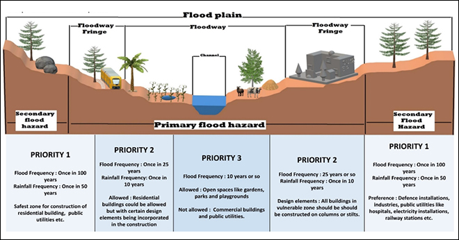
Figure 1: Components of a floodplain and zones proposed under the National Disaster Management Guidelines.
In recent years, floodplains have also been sites for urban development, further increasing the probability of damage as the geographical and demographic growth of a city means an increased exposure to floods. As settlements develop in floodplain areas, the flood hydrology is altered, which in turn aggravates flooding in the immediate downstream, thereby requiring more protection in the form of embankments.11 Floodplain development and the construction of embankments also impact the riparian ecosystem (See Table 1).
Table 1: Types of alterations done to the flood plains and their impactd.
| Alterations | Impact |
| Increase in impervious surfaces | Ø Decreases infiltration and increases runoff, leading to:
Ø Reduction in water seepage and subsequent recharge of floodplain water table |
| Development in-filling on and near floodplains |
Ø Constricts channel flow and capacity Ø Unplanned development leads to prolonged waterlogging Ø Disrupts migration and spawning cues for fish |
| Construction of stormwater drainage systems | Ø Increases velocity and amount of runoff entering river, leading to:
|
| Filling of water bodies |
Ø Disable fish to spawn on floodplain as the nurseries for juvenile fish is lost Ø Reduced storage of flood waters, leading to:
Ø Disrupts migration and spawning cues for fish. |
| Construction of embankments and expansion of agriculture | Ø Change in soil-moisture regime of floodplains
Ø Reduction in lateral movement of river channel
Ø Reduced deposition of nutrients on floodplains |
Source: Adapted from Montz (2000)12, Postel and Richter (2003)13, and modified by the authors.
Embankments further create a false sense of security because it is assumed that they are unbreachable, propagating the idea that they are synonymous with ‘flood protection’. Therefore, to be protected from floods, more embankments are constructed. This ‘levee effect’ results in greater investment into the hazard-prone area since, in the short-run, the veil of ‘flood protection’ ensures that ‘benefits’ are greater as any ‘loss’ due to floods is successfully averted. The value of the embanked areas is also greater, making them more desirable, and contributing to further floodplain development. Since flood-protection works are generally cost-intensive and require funding from multiple sources with little or no cost-sharing mechanism, the beneficiaries are not those who pay for it. This, coupled with the short-term effectiveness of flood-control structures, make embankments immensely lucrative for the local community.14
The construction of embankments have only aggravated the situation in India, and this is most acutely seen in Bihar. The short-sighted flood-protection plan of constructing dams and embankments has backfired. Such structural measures fail to live up to expectations and have worsened the situation,15 and the building of such structures could have dangerous consequences, as seen during the breach of the Kosi embankment in Nepal in 2008 that affected about 50,000 Nepalis and 3.5 million Indians in North Bihar.16
Case Study: Bihar
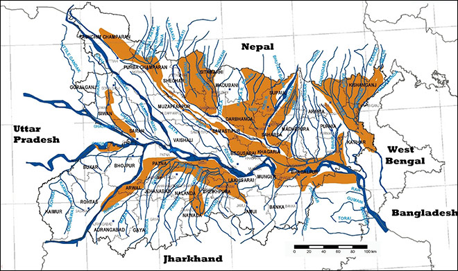
Bihar is one of India’s worst flood-affected states. Around 68.80 lakh hectares—or about 73 percent—of Bihar’s total area is susceptible to flooding, accounting for about 1/5th of the country’s total flood-prone area.17 As much as 82.64 percent of North Bihar and 60.32 percent of South Bihar are flood prone.18
Several large rivers such as the Kosi, Gandaki, Bagmati, Kamala and Mahananda run through North Bihar, joining the mainstream Ganges on its left bank. These rivers carry large volumes of water through the Terai region of Nepal and North Bihar, leaving the area particularly susceptible to floods. Almost all the rivers that flow through this region emerge from the mountains of Nepal or Tibet. The riverbed slopes change abruptly as they enter the floodplains, allowing the silt to be deposited at the base. Moreover, the Lesser Himalayan terrain in Nepal is rising at a rate of 3-4 millimetre per year while the Indo-Gangetic Plain is sinking at a rate of 0.2-0.3 mm/year.19 This difference has led to an increased rate of denudation in the Nepal Himalaya, which in turn has increased the deposition of sediments in the channels. This has contributed to a decrease of gradient in the channels and the slackening of flow. For instance, the denudation rate in the Nepal Himalaya is more than 6 mm/year, which has contributed to the filling of the Baghmati channel at a rate of 9.3 cm/year.20
The accumulation of sediments in the drainage channel and the progressive decrease in the carrying capacity of the channel leads to drainage congestion. Consequently, the water regularly spills over the banks of the channel if there is even slightly higher than normal discharge. This makes Bihar, and particularly its Terai region (comprising the bulk of North Bihar), inherently susceptible to floods.21
Figure 2: Bihar Flood Hazard Map (BMTPC – Vulnerability Atlas of India)22
The impact of floods is further exacerbated by the steadily growing human encroachment of floodplains and the resultant land-use change. This is evident through the decadal increase in population density in Bihar’s flood ‘risk zones’. Zones have been delineated using K-means clustering, as proposed by Matheswaran et al (2019),23 and the Getis–Ord Gi* spatial statistical analysis. Only the districts that overlap in both data sets under each category (high risk and very high risk) are included. As a benchmark, the population density of Bihar and India are plotted on the same graph.
Figure 3: Decadal changes in population density in Bihar
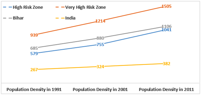
The districts of Darbhanga, Madhubani, Muzzafarpur and Sitamarhi are in the ‘very high risk’ category, while Kishanganj, Madhepura and Supaul are ‘high risk’. The population density in the ‘very high risk’ districts is substantially higher than the state average. It is crucial to consider the change in land use in the two sets of districts through the following categories—area under non-agricultural uses, land under miscellaneous tree crops and groves, and the net sown area. An analysis of data (from Bihar’s Department of Planning and Development) on the ‘very high risk’ and ‘high risk’ zones over two representative years 2004-05 and 2014-15 suggests a three percent increase in exposure for the ‘very high risk’ category and a five percent decline for the ‘high risk’ category. However, the rate of exposure of human interest (a combination of the three types of land use) is very high—greater than 90 percent for the ‘very high risk’ category and greater than 80 percent for ‘high risk’. The net sown area (area under cultivation) comprises more than 60 percent of the total reporting area for land use.
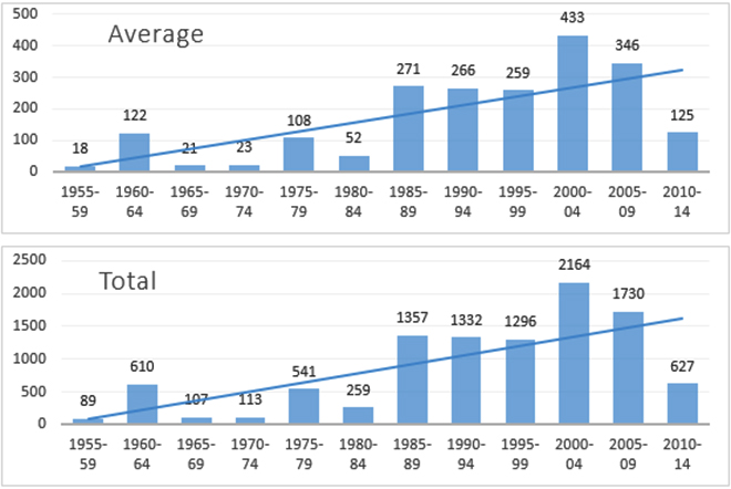
Figure 4: Semi-decadal trend of lives lost due to floods in Bihar.
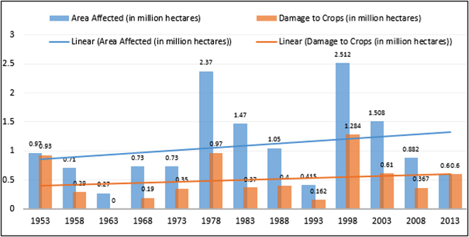
The loss of lives and livelihood in Bihar’s flood-affected regions are a cause for concern. The increased exposure to floods from people inhabiting and altering the floodplains directly impacts the losses incurred due to floods, which have consistently risen over the years (see Figure 5). An analysis of the flood loss for the entire state reveals that the areas affected by floods and the loss to agriculture, as well as lives lost to floods, have consistently increased (see Figures 4 and 5).
Figure 5: Flood losses in Bihar (area affected and damage to crops).
It is thus necessary to consider alternative solutions to reduce the exposure to floods in Bihar and other chronically flood-ravaged parts of the country through concerted policy measures.
The Bihar government has mostly depended on structural measures such as building embankments and barrages to mitigate the risk of flooding. The length of embankments in the state has risen from 160 kms prior to 1954 to 2192 kms in 1974, currently standing at around 3400 kms.24,25 Despite these embankments, the state’s flood-prone area has only increased, as have the number of breaches due to embankment failure.26 Researchers have highlighted the socially maladaptive implications of using embankments to manage flood risk—recursive cycles of vulnerability that has affected the socially weak and has further perpetuated the rampant social and economic inequality in the state.27
Given the ineffectiveness of short-term structural measures in managing floods, Integrated Flood Risk Management plan has been recommended for Bihar. The proposal seeks to minimise the loss of life and infrastructure, preserve the ecosystem, develop floodplains in a sustainable manner, and maximise the net benefits from floodplains.28 Crucial to realisation of such plans in Bihar and elsewhere is legislation and the implementation of floodplain zoning. The Central Water Commission has also long asserted the need for states to adopt a floodplain zoning approach to mitigate damages caused by floods and to allow rivers to have their ‘right of way’.29 The central government’s MBFPZ was circulated to all states in 1975 to encourage discussion and the enactment of state-specific laws. However, resistance from many states, including Bihar, has meant that the floodplains are yet to be demarcated.30
Examining India’s Floodplain Zoning Policies
Flood control and mitigation are not directly mentioned in any of the three legislative lists included in the Constitution. Therefore, based on the inclusion of drainage embankments as entry 17 of List II (State List), flood control has been seen to fall under the purview of the state government, except in the case of “regulation and development of inter-state rivers and river valleys,” which is mentioned in entry 56 of List I (Union List). Floodplain zoning is firmly within the state government’s ambit as it is deals with the land along the riverbanks and land is a state subject under entry 18 of List II. As such, the central government’s role can only be to issue advisories and prescribe guidelines.
The MBFPZ and the NDMG are two key policy documents that reflect the central government’s position on floodplain zoning and capture the governance mechanism that it has tried to impress upon the states. The MBFPZ and NDMG are the only policy documents that lay down the procedural and operative aspects of floodplain zoning in India.e
The MBFPZ is a prescriptive guideline that was sent to all the states in 1975 to enact appropriate legislation and implement floodplain zoning across the country. It is a structure for the states to model their own bills on, but by and large, the states have simply replicated it.
The NDMG was prepared through a nine-step process that included consultations with senior representatives from the central ministries, state governments and related agencies, as well as academics and professionals. It includes an entire chapter on the regulation of floodplains and enforcement of floodplain zoning, emphasising that zoning cannot remedy existing situations but would help minimise flood damage in new areas.31
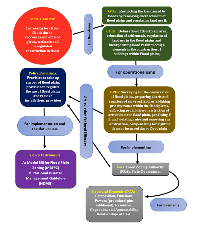
The MBFPZ and NDGM have been analysed through the governance dynamics framework (GDF)32 to assess their strengths, identify gaps and provide recommendations to make the policy instruments more holistic. The GDF is ideal for this assessment as it allows the
unpacking of a policy document and helps to understand how different components are geared towards addressing a social problem. According to this framework, a social issue is the result of the problematic behaviour of some divergent actors. Social problems are matters of concern for society (social concern) for which the government devises policy instruments.
For this analysis, the social concern is ‘Increasing loss from floods due to encroachment of floodplains, wetlands and unregulated construction in floodplains.’ The policy instruments to address this social concern are the MBFPZ and the NDMG. But these instruments will remain ineffective unless the state governments can muster enough political will to pass a legislation.
Similarly, the policies will have to be contextualised according to the existing socio-political and economic realities in each state. This is important for customising the ‘model bill’ and the guidelines to fit the needs and constrains of the region where it is to be implemented. This contextualisation of the MBFPZ and NDGM is beyond the scope of this paper.
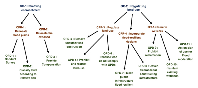
This is the expression or embodiment of the public interest in a particular sector or pertaining to a particular issue. The governance objective clearly spells out the focus of the policy needed to govern the sector. It forms the overall goal before the task of governance. The MBFPZ does not explicitly state any governance objective, making it a ship without a rudder. This lack of clarity permeates throughout the bill. The NDMG, on the other hand, clearly states its objective of regulating land use in the floodplains to restrict the damage caused by floods.
To avoid any ambiguity, policy documents should clearly spell out the two-pronged governance objective—removing the encroachment on the floodplains (GO-1) and regulating the land use within it (GO-2).
The governance objective is followed by certain core strategies that need to be employed for achieving the GOs related to the issue. Together, along with the GOs, the CPRs help to resolve the social concern that begets the exposed community.
The first set of CPRs involve delineating the floodplain area (CPR-1) to take stock of the population that will be exposed to floods (for GO-1), relocating this group of people (CPR-2 for GO-1), and regulating the land use in the floodplain (CPR-3 for GO-2).
A second set of core policy remedies pertain to incorporating flood-resilient design elements in various constructions (CPR-4 for GO-2) and conserving the wetlands within the floodplains (CPR-5 for GO-2).
The MBFPZ explicitly mentions the first set of CPRs, while the NDMG addresses the second set. This shows that the MBFPZ is limited in its scope to achieve GO-2 (regulating the land use within the floodplain). Any state government legislation must be based on both these documents
Operational policy details are the various aspects critical to the effective and efficient operationalisation of the core remedies. For every CPR, there are OPDs that are articulated in the legal language in the form of Policy Provisions.
The MBFPZ stipulates that to delineate the floodplain (CPR-1), a survey establishing the floodplain zones and identifying the areas prone to flooding (OPD-1) must be conducted.
It also mentions the need to classify land according to the risk posed by floodplain use so as to safeguard the health, safety and property of the people (OPD-2).
For the relocation of people from the demarcated zones (CPR-2), the MBFPZ establishes that compensation be provided for any loss or damage incurred due to the prohibition or restriction on any person (OPD-3).
To regulate land use in the floodplains (CPR-3), the MBFPZ stipulates the removal of any unauthorised obstruction after giving the owner or occupier a certain amount of time to comply with the order (OPD-4). But it also says that no compensation will be paid for the removal of encroachments. The MBFPZ also states that the government may prohibit or restrict the activities in the floodplain (OPD-5), or penalise those found guilty of carrying out or attempting to carry out restricted activities in the floodplain (OPD-6) to regulate the use of such land (CPR-3).
The MBFPZ makes no mention of CPR-4 (incorporating flood-resilient design elements in various construction within the floodplains) and CPR-5 (conserving the wetlands), but they are discussed in the NDMG.
The NDMG mandates that infrastructural activities in flood-prone areas be made flood-resilient (OPD-7). It also discusses the development of an appropriate legal framework by the state governments or disaster management authorities to make it mandatory to obtain clearances for all proposed constructi in the flood-prone areas (OPD-8).
The NDMG outlines three operational policy details for the conservation of the wetlands within floodplains (CPR-5)—prohibiting the reclamation of the existing wetlands/natural depressions (OPD-9), reviving and maintaining the existing wetlands in the floodplains (OPD-10), formulating an action plan to use the wetlands for flood moderation (OPD-11).
Figure 6: The governance objectives, core policy remedies and operational policy details
Policy provisions help articulate the different operational details and are often called sections or are present as individual rules.
The MBFPZ’s policy provisions are quite broad. For OPD-1 (conducting a survey to establish the floodplain zones and identify flood-prone areas), it merely says that proper charts and registers should be prepared with details of all boundaries to determine the limits of the floodplain. It also mentions that the land in the floodplain should be classified with reference to the relative risk of the floodplain, but it does not elaborate on just how such a classification should be made.
The NDMG provides some guidelines on conducting a survey to establish the floodplain zones and identify flood-prone areas (OPD-1). According to it, the state government should prepare maps for areas vulnerable to flooding at a scale of 1:15,000 by using the markings of reference river gauges. If such marks are not available, then the exercise should be done on larger scales of 1:25,000 or 1:50,000. The NDMG also suggests that the demarcation should consider floods of various frequencies (once a year, every two years and so on) and the area likely to be affected by the accumulation of rainfall at the different frequencies.
The NDMG also includes detailed policy provisions for OPD-2 (classification of land according to relative risk). According to the guidelines, areas likely to be affected by floods at up to a ten-year frequency should be reserved for gardens, parks and playgrounds with a prohibition on residential and commercial buildings and public utilities (PP-3). In areas likely to be affected by floods at a medium frequency (25 years), residential buildings could be allowed but only after incorporating certain design elements, such as using stilts, during construction (PP-2). In areas likely to be affected by floods at the highest frequency (100 years), all important and emergency establishments, such as defence installations, hospitals, electricity installations, water supply infrastructure and railway stations, could be allowed (PP-1).
The MBFPZ provides a mechanism to calculate the compensation for any loss or damage incurred through the prohibition of land use (OPD-3), stipulating that it should not exceed the difference between the value of land as determined by the Land Acquisition Act and its value had it been used for the purpose intended. Further provisions detail the process to be followed if there is no agreement between the governing agencies and the person concerned, and conditions under which compensation will not be provided—if a law restricting the use of the land existed before the state law on floodplain zoning came into being, and in instances of removal of unauthorised obstructions (OPD-4).
The MBFPZ specifies that the government must notify through the official gazette if it plans to prohibit or restrict the activities in the floodplain (OPD-5), mentioning the areas where the prohibitions are applicable and their nature. The NDMG provides the details of these restrictions (see Figure 1), which is missing from the MBFPZ.
The MBFPZ also stipulates that a fine of up to INR 500 be imposed on those found guilty of carrying out or attempting to carry out restricted activities in the floodplains (OPD-6), with further remedies for failure to pay the fine.
The NDMG contains policy provisions for making flood-resilient public infrastructure (OPD-7). First is to construct buildings above a level corresponding to the interval of flood occurrence that has been designated for that priority zone. The NDMG also states that some drains should be designated as green belts to disallow the construction of any building.These could be used as passages for the excess water to flow out or as parks and gardens that will not obstruct the flow of water. For the construction of buildings within the floodplains, the NDMG specifies having plinth levels above 0.6 metre from the drainage/flood submersion line. Moreover, in flood-prone areas, buildings should be multi-storeyed. For single-storeyed buildings, NDMG provisions dictate that a stairway to the roof be provided. The roofs of single-storeyed buildings and the first-floor of double- and multi-storeyed buildings must be above the 100-year flood levels.
The MBFPZ and NDMG have vague policy provisions for OPD-8 (mandatory clearance to construct infrastructure in flood-prone areas), OPD-9 (prohibiting the reclamation of existing wetlands), OPD-10 (reviving and maintaining existing wetlands) and OPD-11 (formulating a plan to use the wetlands for flood moderation).
The provisions for OPD-8 partially overlap with those for OPD-5, but it makes no mention of clearances for constructing infrastructure. One way of taking OPD-9, OPD-10 and OPD-11 forward is to by leveraging the Wetlands (Conservation and Management) Rules, 2017, the elaborate guidelines for which have been sent to the states in 2020.33
These are the organisations or officials entrusted with the responsibility of carrying out the governance functions, including determining the objectives. The MBFPZ stipulates that state governments should appoint a District Collector or similar level official as the Flood Zoning Authority (FZA) to oversee the implementation of its rules. The FZA is tasked with delineating the floodplain and has been empowered to enter any premises to conduct surveys, issue notices to owners of land in the restricted zones, and disburse compensations.
At the same time, the MBFPZ makes no mention of the resources available to the FZA to carry out its functions. The allocation of funds to the FZA is a critical component that will determine its efficacy. Similarly, although the FZA is accountable to the state government, the MBFZA does not specify under whose purview the authority lies, nor is there any mention of how the FZA will coordinate with other departments such as revenue, irrigation, water resources and agriculture, and agencies like the State Disaster Management Agency .
The MBFPZ (the primary floodplain zoning policy document) and NDMG (essentially a set of prescriptive guidelines) lack clarity on several issues, including addressing the social impacts (loss of lives and property) that arise from living on or near floodplains. Besides, floodplain zoning is an extremely sensitive issue and must be customised based on the socio-political and economic realities of the states where it is needs to be enacted.
Technology has improved manifold since the MBFPZ was prepared. Presently, the National Flood Vulnerability Assessment System on Bhuvan provides an important storehouse of resources for drawing scenarios on the basis of topography, trends in spatial rainfall, spatial runoff and flood vulnerability index. It also contains a few case studies and technical reports.34 In a bid to boost disaster risk reduction, the ISRO’s National Remote Sensing Centre has also initiated the development of flood hazard zonation maps in addition to flood response services through the decision support centre.
A district-wise flood hazard zonation atlas is already available for Bihar, which has taken into account historical flood scenarios spanning over 13 years and intra annual flood variation from 1998-2010.35 Even though the scale has to be reduced further to undertake any meaningful floodplain zoning measure, technological advancement has eased this process. However, it will require the cooperation of the states, especially for activities like validation on the ground and tabulating the list of families that will be provided with compensation. Traditionally, the Revenue Department has been entrusted with the responsibility of surveying and providing relief to the people affected by natural calamities like floods. The interaction of the FZA with the Revenue Department needs to be clearly stated in the legislation for ease of operations.
Land acquisition is an area of contestation and governments have often been accused of unfair compensation and inadequate rehabilitation efforts.36 Moreover, the removal of any illegal encroachment without any compensatory mechanism is unbecoming of a welfare state like India. All procedures must comply with the constitutional mandate to protect the health and well-being of all citizens, especially those in financial or social need. Appropriate legal mechanisms must be developed to address these sensitive issues. Another important issue is finding suitable land to rehabilitate the displaced communities, a challenge that is seemingly greater than the cause in the densely populated riverine landscapes of Eastern Uttar Pradesh, North Bihar, West Bengal and Lower Assam.
The GA is crucial for the implementation of the PPs—and thereby the CPRs and OPDs contained within the PPs—but the present policy architecture lacks clarity on this. Despite the multitude of tasks that need to be carried out, sequentially and in tandem, only one GA (the FZA) has been specified in the MBFPZ, with severe limitations. There is no mention of any GA that will be responsible for delivering OPD-5 and CPR-4, both of which pertain to land-use management in the zones and ensuring that the constructions conform with the design requirements of the zone. Similarly, for implementing CPR-5 (conservation of wetlands) and all the OPDs contained within it, it is extremely likely that the State Wetland Authority, created under the Wetlands (Conservation and Management) Rules, 2017, will play a pivotal role. It is not clear how the FZA or any other relevant authority will interact with the State Wetland Authority since many such wetlands would be in the floodplains and in the periphery of urban localities. There is clearly a case of overlapping jurisdictions, and the roles and responsibilities of the various agencies need to be defined properly in any floodplain zoning legislation.
Figure 7: Unpacking the provisions for flood plain zoning (by combining A and B) as it exists.
Conclusion
Despite the crucial need for floodplain zoning, several states have resisted such efforts, including the enactment of a law. Only three states—Manipur, Rajasthan and Uttarakhand—have enacted laws pertaining to floodplain zoning, while others, particularly the flood-affected Bihar and Assam, have shown varying degree of opposition. There could be two reasons for their reticence: the constraints arising from evacuating the people who occupy the floodplains, and resettling these people elsewhere given the paucity of land. Removing these bottlenecks is crucial for the successful realisation of floodplain zoning and to put in place an integrated approach for flood management.
Manipur enacted the floodplain zoning legislation in 1978 and has made concerted efforts to implement it fully. By 1988, the flood zoning area had been published, and the most recent activity has been an eviction campaign to free the banks of the Imphal river.37 Although Rajasthan has also passed a law on floodplain management, it has not been enforced. Uttarakhand has issued two floodplain zoning notifications for two tehsils of the state—Haridwar and Uttarkashi for zones extending horizontally to 50 kms and 10 kms, respectively. These contain elaborate information on the landholding that lies within the restricted zones.38 The Tamil Nadu government had proposed forming a committee provide recommendations to enact a floodplain zoning law, but no concrete efforts were made towards this goal.39 Uttar Pradesh and Bihar, which are among India’s worst flood-affected states, have conveyed that implementing a floodplain zoning law is neither practical nor implementable, although the UP government has taken measures to regulate the economic and development activities in the floodplains in the state. The West Bengal government has made some progress by preparing a draft bill on floodplain zoning and the Madhya Pradesh government has demarcated 36 towns affected by floods and has carried out the necessary administrative work towards the demarcation of flood zones.40
Regulating floodplain use in India has largely been a flawed exercise. The constitutional provision of flood management falls under the purview of the state governments, while central government organisations such as the Ganga Flood Control Commission, Brahmaputra Board and the Central Water Commission can only provide technical support to the states. It is up to the states to weigh the costs and benefits of floodplain zoning as a viable flood management option. For many states, the costs outweigh the benefits. In the third meeting of the ’Working Group on Flood Management and Region Specific Issues’ for the XII Five Year Plan (2012-17) in April 2011, Bihar’s engineer-in-chief and the secretary of Assam’s Water Resources Department said that floodplain zoning may not be a solution for their states given the difficulty of shifting people to safer areas.41 Although some states have appeared willing to implement floodplain zoning on the condition that the central government provide sufficient incentives, the mechanism is yet to be devised, leaving floodplain zoning an unrealised proposition.
This provides an opportunity to consider alternative institutional arrangements to achieve the goal of operationalising floodplain zoning at the basin level. River Basin Organisations (RBOs), which are democratic in nature and have better professional standings than state governments,42 can be entrusted with the task of initiating a dialogue on floodplain zoning in contiguous states that are ravaged by floods. The RBOs must be given adequate autonomy to undertake decisive and concerted actions in coordination with state governments to achieve the governance objectives of removing encroachments on the floodplains and regulating the land use within it. Moreover, many Himalayan rivers flow through multiple countries, and so, their floodplains are also distributed in the contiguous areas of different nations. An RBO is best suited to manage such floodplains by adhering to the tenets of Integrated Flood Management (IFM).
The Mekong River Commission (MRC), for instance, was set up with the mandate, among others, of resolving the transboundary issues, differences and disputes caused by floods. The Regional Flood Management and Mitigation Centre was set up in 2003 after two consecutive years of severe flooding caused massive economic and human loss. The MRC’s Flood Management and Mitigation Program (FMMP), an adaptive response to environmental threats, has been one of its most successful programmes due to relatively low levels of uncertainty regarding exposure to the stressor (floods) and its impact.43 The key activities carried out under the FMMP programme between 2004 and 2010 included using flood simulation models to understand and resolve transboundary flood issues, strengthen flood emergency management through improved inter-provincial and inter-country assistance, and incorporate flood hazard into land-use decision-making by local communities and governments.44 The MRC has also adopted an integrated IFM to develop a coherent regional policy with land-use planning and social policies around flood resilience as its cornerstones.45
The IFM recognises the river basin as a dynamic system with multiple interactions and flux between land and water bodies,46 and necessitates the integration of natural and human systems within the framework of integrated water resources management (IWRM).47 The IFM can adapt by taking into account existing knowledge on issues like climate change, and identify the ideal combination of strategies. Further, the IWRM “promotes the coordinated management and development of water, land and related resources, in order to maximize the resultant economic and social welfare in an equitable manner without compromising the sustainability of vital ecosystems and the environment”48. As a result, the IFM can be understood as maximising benefits from the use of floodplains and minimising loss of life from flooding. The approach aims to reduce flood risks through a judicious combination of measures dealing with the magnitude of the hazard and the community’s exposure and vulnerability to it.49 The MRC has shown that informal technical cooperation in the transnational or subnational realm has been readily practiced. But an RBO makes all the difference when it comes to institutional and political cooperation, which is important in the long-run to make the process sustainable and effective.50
An overhaul of the current floodplain zoning policy architecture is the need of the hour. There are several structural gaps in the MBFPZ and the NDMG. Any policy measure that seeks to achieve the governance objectives of restricting the losses caused by floods and regulating land use within floodplains should look to fill these gaps. Globally, floodplain zoning has emerged as an important strategy at the basin level. India needs to adopt a forward-looking and proactive policy design that is embedded in an IFM-based approach and operationalise it within the entirety of a river basin.
Annex – 1
| Years | Total Lives Lost | Average Lives Lost | Standard Deviation |
| 1955-59 | 89 | 18 | 19 |
| 1960-64 | 610 | 122 | 240 |
| 1965-69 | 107 | 21 | 14 |
| 1970-74 | 113 | 23 | 33 |
| 1975-79 | 541 | 108 | 86 |
| 1980-84 | 259 | 52 | 56 |
| 1985-89 | 1357 | 271 | 473 |
| 1990-94 | 1332 | 266 | 496 |
| 1995-99 | 1296 | 259 | 82 |
| 2000-04 | 2164 | 433 | 272 |
| 2005-09 | 1730 | 346 | 533 |
| 2010-14 | 627 | 125 | 78 |
Table for Number of lives lost due to floods in Bihar.
| Name of the District | Population Density in 1991 | Population Density in 2001* | Population Density in 2011 | |
| Kishanganj | 522 | 687 | 750 | |
| Madhepura | 659 | 853 | 1116 | |
| Supaul | 557 | 724 | 1258 |
Table for change in population density of districts in the ‘very high risk’ category.
| Name of the District | Population Density in 1991 | Population Density in 2001* | Population Density in 2011 | |
| Darbhanga | 1,102 | 1,442 | 1803 | |
| Madhubani | 809 | 1,020 | 1220 | |
| Muzaffarpur | 931 | 1,180 | 1506 | |
| Sitamarhi | 915 | 1,214 | 1491 |
Table for change in population density of districts in the ‘high risk’ category.
a According to the draft River Conservation Zone (Regulation of Harmful Activities) Rules, 2012, an active floodplain is defined by high flood line (HFL), which in entrenched /embanked stretches of river is the available space (including the river channel/s) in the valley of entrenched stretch, or between two embankments, or between existing roads on either side along a river acting as an embankment. In other stretches of the river HFL, active floodplain shall be the 100-year flood line.
b For all practical purposes, only the floods caused due to monsoonal precipitation is being considered as a hazard. Coastal and estuarine flooding, flooding due to snow and ice-melt during spring and early summer, glacial lake outburst flooding, and flooding due to cloudburst are not being considered.
c In this study, the term ‘encroachment’ is being used to highlight any human intervention, legal or illegal, that takes place in the ‘active floodplain’ without conforming to the zonal requirements as mentioned in the National Disaster Management Guideline. The authors would like to emphasise that encroachment is being viewed as ‘encroaching into the river’s space’.
d The alterations to the floodplains and the resultant impact are not fool proof. Some alterations could have overlapping impacts. For simplicity, the authors have identified the most important causal-effect relation to categorise the information.
e The Draft River Conservation Zone (Regulation of Harmful Activities) Rules, 2012 has been excluded since its focus is to prevent water pollution in river stretches and cause destruction to river morphology and biota, which would lead to drying of river systems.
1 “World’s 15 Countries with the Most People Exposed to River Floods,” World Resources Institute, last modified March05, 2015, https://www.wri.org/blog/2015/03/world-s-15-countries-most-people-exposed-river-floods
2 European Commission, “Directive 2007/60/EC of the European Parliament and of the Council of 23 October 2007 on the assessment and management of flood risks.” Official Journal L 288/27, 6/11/2007 (2007): 8
3 IIT (Indian Institutes of Technology), Active Flood plain Mapping: Defining the “River Space”. GRB EMP : Ganga River Basin Environment Management Plan, 2010, http://cganga.org/wp-content/uploads/sites/3/2018/11/021_FGM.pdf
4 Jayanta Bandyopadhyay, Water, Ecosystems and Society: A
Confluence of Disciplines(New Delhi: SAGE Publications India Pvt Ltd. , 2009), 49.
5 Richard S. Wydoski and Edmund J. Wick, “Flooding and aquatic ecosystems,” in Inland Flood Hazards: Human, Riparian, and Aquatic Communities, ed. Ellen Wohl (Cambridge: Cambridge University Press, 2000), 238-268.
6 Dinesh KumarMishra, “The Bihar flood story,” Economic and Political Weekly (1997): 2206-2217.
7 Dinesh Kumar Mishra, “Living with Floods: People’s Perspective,” Economic and Political Weekly (2001): 2756-2761.
8 Rohan D’Souza,”Water in British India: the making of a ‘Colonial Hydrology’.” History Compass 4, no. 4 (2006): 621-628.
9 Wydoski and Wick, “Flooding and aquatic ecosystems,” 238-268.
10 Ellen Wohl, “Geomorphic Effects of Floods,” in Inland Flood Hazards: Human, Riparian, and Aquatic Communities, ed. Ellen Wohl (Cambridge: Cambridge University Press, 2000), 167-193. doi:10.1017/CBO9780511529412.007
11 Burrell E. Montz, “The generation of flood hazards and disasters by urban development of Flood plains.” in Floods, ed. Dennis J. Parker (London: Routledge, 2000), 116-127.
12 Ibid.
13 Sandra Postel and Brian Richter, Rivers for life: Managing water for people and nature (Washington DC: Island Press, 2003)
14 Montz, “The generation of flood hazards and disasters by urban development of Flood plains,” 116-127
15 Mishra, “The Bihar Flood Story,”2206-2217.
16 Ajaya Dixit. “Kosi embankment breach in Nepal: Need for a paradigm shift in responding to floods,” Economic and Political Weekly (2009): 70-78.
17 Kumar,Santosh, Arun Sahdeo, and Sushma Guleria,BIHAR FLOODS: 2007 (A Field Report),2013, National Institute of Disaster Management,Accessed July15, 2019 https://nidm.gov.in/PDF/pubs/Bihar%20Flood%202007.pdf
18 ‘Vulnerability Atlas of India’ Building Material and Technology Promotion Council, accessed February 15, 2020, http://bmtpc.org/DataFiles/CMS/file/VAI2019/bihar.html
19 Santosh, Sahdeo and Guleria, BIHAR FLOODS: 2007 (A Field Report )f
20 K. S. Valdiya, “Bracing for flood hazards.” Current Science 101, no. 1 (2011): 16-17.
21 Ibid.
22 Ibid.
23 BMTPC, “Vulnerability Atlas of India”
24 Karthikeyan Matheswaran, Niranga Alahacoon, Rajesh Pandey and Giriraj Amarnath, “Flood risk assessment in South Asia to prioritize flood index insurance applications in Bihar, India,” Geomatics, Natural Hazards and Risk, 10:1(2019) : 26-48, 10.1080/19475705.2018.1500495
25 V.K. Singhand S. Singh ‘Strategies for flood mitigation in Bihar: an assessment of its effects and future orientation’, Pragyaan: Journal of Management 6(2) (2008) :71–84.
26 R.K. Shrestha, R. Ahlers, M. Bakker and J. Gupta ‘Institutional dysfunction and challenges in flood control: a case study of the Kosi flood 2008’, Economic & Political Weekly 45(2), (2010) 45–53.
27 Singh and Singh, “Strategies for flood mitigation in Bihar: an assessment of its effects and future orientation,” 71-84
28 Bill Pritchard and Rebeka Thielemans, “Rising Waters Don’t Lift All Boats’: a sustainable livelihood analysis of recursive cycles of vulnerability and maladaptation to flood risk in rural Bihar, India,” Australian Geographer, 45:3 (2014) 325-339,10.1080/00049182.2014.930001.
29 Mitthan Lal Kansal, Prashant Kumar and Kumar Abhishek Kishore. 2016.”Need of Integrated Flood Risk Management (IFRM) in Bihar.” Presentation at the National Conference on Water Resources and Flood Management with Special Reference to Flood Modeling.
30 Planning Commission, Report of Working Group on Flood Management and Region Specific Issues for XII Plan,New Delhi, 2011, http://www.indiaenvironmentportal.org.in/files/file/flood%20management%20and%20region%20specific%20issues_India_uttarakhand_Odisha_Bihar.pdf (accessed Feb 7, 2020)
31 Ibid.
32 NDMA National Disaster Management Guidelines: Management of Floods,New Delhi,, 2008 https://ndma.gov.in/images/guidelines/flood.pdf (Accessed March 13th, 2020)
33 Subodh Wagle (Professor, CTARA, IIT Bombay) in discussion with Sayanangshu Modak, February, 2020.
34 Mayank Aggarwal “States can alter activities prohibited in wetlands as per latest guidelines,” Mongabay, January 14, 2020, https://india.mongabay.com/2020/01/states-can-alter-activities-prohibited-in-wetlands-as-per-latest-guidelines/
35 “Disaster Management Support,” Applications, National Remote Sensing Centre, accessed March 31, 2020, https://www.nrsc.gov.in/KR_Atlas_FloodHazardZonation?language_content_entity=en.
36 “Flood Hazard Zonation Atlas,” Resources, National Remote Sensing Centre, accessed March 31, 2020, https://www.nrsc.gov.in/KR_Atlas_FloodHazardZonation?language_content_entity=en.
37 Sakarama Somayaji and Smrithi Talwar, Development–induced displacement, rehabilitation and resettlement in India: current issues and challenges(Taylor & Francis, 2011)
38Staff Reporter, “DCs asked to sanitise Imphal River banks: Letpao,” The People’s Chronicle, Jan 5th 2019, http://www.thepeopleschronicle.in/daily/english/866
39“Flood Plain Zoning Notification” Uttarakhand Irrigation Department, accessed May 10, 2020, https://uttarakhandirrigation.com/flood-plain-zone-notification
40 Union Government, Ministry of Water Resources, River Development & Ganga Rejuvenation,Report of the Comptroller and Auditor General of India on Schemes for Flood Control and Flood ForecastingReport No. 10, 2017 .
https://cag.gov.in/content/report-no10-2017-performance-audit-union-government-schemes-flood-control-and-flood (Accessed Feb 22, 2020)
40 NDMA, National Disaster Management Guidelines: Management of Floods.
41 Planning Commission, Report of Working Group on Flood Management and Region Specific Issues for XII Plan.
42 Nilanjan Ghosh, Jayanta Bandyopadhyay,“Sustaining the Liquid Mosaic: Longer Steps Needed,”Economic and Political Weekly 51:52, (2016) : 20-24
43 Heikkila, Tanya, Andrea K. Gerlak, Andrew R. Bell, and Susanne Schmeier, “Adaptation in a transboundary river basin: Linking stressors and adaptive capacity within the Mekong River Commission,” Environmental science & policy 25 (2013): 73-82.
44 MRC Annual Mekong Flood Report 2011 Mekong River Commission, 2015 https://www.mrcmekong.org/assets/Publications/basin-reports/Annual-Mekong-Flood-Report-2011.pdf (Accessed May 12, 2020)
45 Ibid.
46 WMOIntegrated Flood Management: Concept Paper, WMO- No. 1047, Geneva, Switzerland, World Meteorological Organization, 2009, https://www.floodmanagement.info/publications//concept_paper_e.pdf (Accessed on March, 2020)
47 WMO,Social Aspects and Stakeholder Involvement in Integrated Flood Management, Flood Management Policy Series,WMO- No. 1008,, 2006,
https://www.floodmanagement.info/portfolio-item/social-aspects-and-stakeholder-involvement-in-integrated-flood-management/(Accessed March 15, 2020)
48 ‘About IWRM’, Global Water Partnership-South AsiaTowards a water secure world, Accessed March 15, 2020,
https://www.gwp.org/en/gwp-SAS/ABOUT-GWP-SAS/WHY/About-IWRM/
49 WMO, Integrated Flood Management: Concept Paper
50 MRC, Annual Mekong Flood Report 2011
The views expressed above belong to the author(s). ORF research and analyses now available on Telegram! Click here to access our curated content — blogs, longforms and interviews.

Sayanangshu Modak was a Junior Fellow at ORFs Kolkata centre. He works on the broad themes of transboundary water governance hydro-diplomacy and flood-risk management.
Read More +
Preeti Kapuria was a Fellow at ORF Kolkata with research interests in the area of environment development and agriculture. The approach is to understand the ...
Read More +