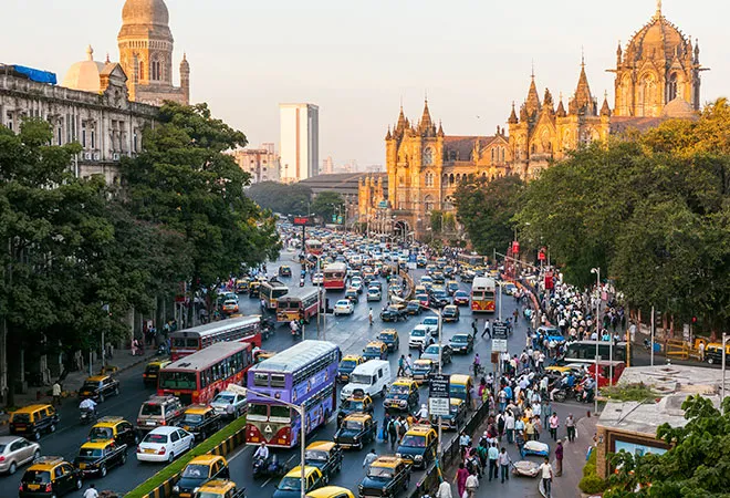
Mumbai is known for its enterprise, vibrant culture, and rich heritage; however, it is also plagued by perennial traffic congestion. Mumbai has one of the world's worst road traffic, ranked as
the fifth most congested city. Mumbai's traffic conditions have
steadily deteriorated. As of 2021, the city's
congestion rate – average time spent on travel – was 53 percent longer than baseline non-congested levels, meaning a 30-minute trip takes up to 20 minutes longer at the peak congestion level. These traffic congestions have several long-term effects on individual health and well-being and the city's overall economy. Mumbai suffers an economic loss of
INR 410 billion due to traffic jams, with
121 hours lost yearly.
One of the numerous factors that cause Mumbai's traffic problems is the city's linear geography. Cities like New Delhi and other metros have radial geography, so they grow outwards and have multiple routes connecting one location to another. Mumbai, on the other hand, is surrounded by the Arabian Sea, which limits its growth. With only two major highways, the Western Express Highway and the Eastern Express Highway, connecting the north and south, the roads become congested during peak rush hours. Besides, Mumbai has
4.1 million vehicles on the road, which also causes traffic. The car density in Mumbai has risen to
600 cars per kilometre of road, which is the highest in India. Heavy encroachment and
bottleneck areas like Powai-Vikhroli and Saki Naka in the suburbs cause heavy congestion during peak hours.
The space taken for the metro's ongoing construction has reduced the number of lanes on the road to two or three on average in some parts of the city.
Concerning public transport alternatives, the city's suburban railway is overburdened, ferrying up to
8 million people daily. At the same time, BEST, the municipal bus service, struggles to remain
financially viable. A lack of a well-established metro network exacerbates this. The space taken for the metro's ongoing construction has reduced the number of lanes on the road to two or three on average in some parts of the city.
Mimicking Tokyo’s traffic management
Globally, several cities with similar traffic densities have innovatively used real-time traffic data and technology to combat congestion on their streets. Learning from the experiences of other cities can help alleviate Mumbai's worsening traffic conditions and offer sustainable solutions. This article uses Tokyo as a model city. It evaluates the successful data- and tech-based interventions made by Tokyo to identify ways to improve Mumbai's current road traffic situation. Tokyo's traffic management model also guided
Dhaka's successful interventions to solve traffic anarchy and gridlock issues in the capital of Bangladesh.
Tokyo has one of the world's
most sophisticated and disciplined traffic management systems. As of 2022, it has one of the largest populations of any city-
13.9 million. It also has an effective road management system, enabling the city to run smoothly. Compared to Mumbai's 4.1 million automobiles, it has
3.2 million vehicles on the road. Shibuya and Chuo are similar to BKC and Lower Parel in terms of business districts, and Tokyo's
rush hour schedule is similar to
Mumbai's. Tokyo, thus, presents an ideal template in traffic management that Mumbai can adopt after location- and user-specific customisation.
Globally, several cities with similar traffic densities have innovatively used real-time traffic data and technology to combat congestion on their streets.
Tokyo adopted
the Vehicle Information and Communication System (VICS) in 1996. It offered real-time traffic updates and vehicle navigation. VICS involved several steps, yet it allowed for efficient traffic flow. The initial stage was information gathering; street-level cameras and radars provided VICS centres with real-time data for analysis and compilation. The gathered data is supplied to real-time car navigation systems through three different media at the VICS Centre and edited or processed to make it easier to read or relay over radio communication. They also have an
electronic toll collection system (ETC), similar to
FASTag used in India, which prevents crowding and congestion of vehicles. VICS and ETC have been critical in reducing traffic congestion in Tokyo.
VICS offers numerous ways to improve Mumbai's current traffic situation. Google Maps provides real-time traffic updates and any accidents or road diversions. By integrating Google Maps with traffic management devices such as traffic signals, speed limits, marker signs, etc., Mumbai can also use this system to reduce traffic congestion on the roads. Integrating traffic signals and speed limits into a centralised system using a common wired connection or a wireless network is critical. This central system is known as a Traffic Data Bank. We can use real-time traffic updates available on Google Maps and send them across the data bank using wired or wireless connections to traffic signals and speed limits to regulate traffic accordingly by integrating this traffic data bank with Google Maps. The data bank would also keep information on rush hours and bad roads and use artificial intelligence to work on the traffic accordingly. This real-time communication using data analysis will allow a smooth and regulated traffic flow. Dhaka adopted Tokyo's traffic management system to enhance traffic movement and reduce accidents. In accident-prone locations, it used a data collection system akin to the one in Tokyo. They would then analyse this data to identify accident patterns and develop recommendations to reduce such accidents in the future.
Traffic congestion is quickly becoming the next decade's primary environmental concern issue. Road traffic is the fastest-growing source of greenhouse gases; road construction is one of the most significant single causes of wildlife habitat destruction; both traffic and new roads are responsible for increasing general intrusion and problems in the local environment. Transport directly impacts people's lives, and public perceptions of a “transport crisis” are growing pressures for policy changes; this provides an opportunity to propose environmentally sustainable transportation policies while also addressing the transportation problem. Therefore, the poor implementation of policies needs to be fixed to ease traffic congestion and provide adequate and reliable public transportation services.
By integrating Google Maps with traffic management devices such as traffic signals, speed limits, marker signs, etc., Mumbai can also use this system to reduce traffic congestion on the roads.
Mumbai will have a massive road structure, the
Mumbai Coastal Road Project, by the end of 2023, designed to improve connectivity significantly in South Bombay. It is an eight-lane project with bike lanes and bus stops. It claims to reduce travel time by 70 percent, saving 34 percent fuel. This project would greatly improve traffic in Mumbai but not for too long due to
induced demand. Induced demand refers to increasing roadway capacity, and encouraging more people to drive, thus, failing to improve congestion.
Improving road conditions is necessary for faster and smoother travel. But it is essential to reduce the number of vehicles on the road to reduce traffic congestion. The city governments must maintain the roads regularly to prevent any breakdowns leading to traffic jams. The key to managing road traffic is to reduce the number of vehicles on the roads by having a well-established metro system and other forms of public transport, having robust footpaths and walkways that would reduce the incentive for people to use their private vehicles. The provision of such measures would encourage the use of public transport and reduce the effect of induced demand.
Conclusion
In conclusion, learning from Tokyo's traffic model and implementing a system that integrates Google Maps with traffic management devices and a central Traffic Data Bank is a viable solution for improving Mumbai traffic. By utilising real-time traffic updates and artificial intelligence to optimise traffic flow, this approach may help to reduce road congestion and improve overall traffic flow in the city. In addition to using technical solutions, the government must periodically maintain the roads to avoid breakdowns. A well-established metro and last-mile connectivity will improve the entire road infrastructure. Encouraging carpooling and public transport use will also benefit the environment by lowering fuel consumption and greenhouse gas emissions.
The views expressed above belong to the author(s). ORF research and analyses now available on Telegram! Click here to access our curated content — blogs, longforms and interviews.