Introduction
Before 1984, few people in India or Pakistan had heard about the Siachen Glacier as it was never a fact in issue between the two countries and rarely figured in any security discourse or interaction between the sides.[1] Even three bloody wars between the two neighbours and several mountaineering expeditions in the region had failed to disturb the peace in the area. However, this changed when Pakistan’s formal claim to the entire region—contrary to its admitted position that it was disputed and yet to be demarcated[2]—triggered a pre-emptive Indian reaction on 13 April 1984. On this day, the Indian armed forces launched Operation Meghdoot and moved onto Saltoro Heights, taking effective control of the entire Siachen Glacier region.
Notably, Siachen caught the attention of the Indian military planners only around 1978, when details of all the mountaineering expeditions taking place in the region were dug out and analysed.[3] In fact, most of the published work on military activities in the region and Pakistan’s arguments conceived in hindsight to justify its claim over the area emerged only after India took control of the Saltoro Heights in 1984.[4]
While much has been written about the September 1978 Indian expedition to Teram Kangri led by Col. Narinder ‘Bull’ Kumar, little is known about the Pakistani activities in the region, especially the German Bilafond-Siachen-Kondus expedition that took place in the same year. This expedition was conceived by two German explorers, physicist Jaroslav Poncar and mathematician Volker Stallbohm, who, along with Wolfgang Kohl and Major Asad Raza, reached the Siachen Glacier in the summer of 1978 from the Pakistani side. Incidentally, Poncar and Stallbohm were also instrumental in triggering Kumar’s interest in East Karakoram. But how did they meet him in the first place? How did they end up on Siachen from the Pakistani side, and, more importantly, what drew Kumar's and India’s attention to the glacier?
This report presents Poncar’s and Stallbohm’s accounts of events over 45 years after the expedition, collated through in-person and online interviews and self-published works.[5] While Kumar and Lt. Gen. M.L. Chibber’s works detailing the Indian interest in Siachen are well known, Poncar and Stallbohm’s version closes the loop and gives fresh insights into their own interest in Siachen, their interactions with Kumar and the map they gave him,[6] which piqued his curiosity and started the race to Siachen.
Jaroslav Poncar and Volker Stallbohm’s Reflections
Poncar on meeting Kumar for the first time:
I came to India for the first time in July 1974 when travel restrictions to Ladakh were lifted. From Delhi, I landed in Srinagar and then took the bus to Leh after purchasing the ticket with great difficulty, as no one believed that the restrictions had been lifted just a week ago. During this trip, I saw the spectacular landscapes of Lamayuru and was mesmerised by the descent from the Kangoo Loops to the Indus Valley. During the rest of the drive to Leh, while travelling along the Indus, I began thinking of a possible boat trip on the river till Khalsi. Back home in Germany, I checked and found that it had not been done before and started planning for it. I returned to India in the summer of 1975, accompanied by my friend Volker Stallbohm, and we brought along an inflatable boat for the expedition. The Indus Valley beyond Leh was open to foreigners only up to Upshi, about 40 kilometres further east while we intended to navigate the Indus from Demchok where it enters India as Senghe Chu, almost 300 kilometres beyond Upshi. The Ministry of Home Affairs was not inclined to give us the inner line permit for riding a boat in a strategically important region. So, on the advice of Magdalene Duckwitz, the Cultural Counsellor at the German Embassy in Delhi, we decided to meet, the chief minister of Jammu and Kashmir, Sheikh Abdullah, and seek his help.
Image: The picture of Sheikh Abdullah taken by Jaroslav Poncar in 1974.
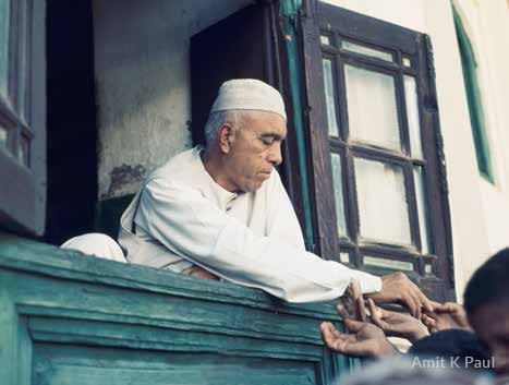
Source: Amit K Paul, reproduced with permission from Jaroslav Poncar.
We reached Srinagar and sought an appointment; he agreed to meet us the following day. I had taken a picture of Sheikh Sahab at Hazratbal in 1974 when he was released from house arrest and was carrying it in my luggage. So, dressed in simple jeans, we stood before Sheikh Abdullah and presented him with the picture. He was very pleased and asked what he could do for us. When we informed him about the expedition, he asked his secretary to connect us with Kumar and then took us to a cultural programme he had arranged for the wife of the president of Guyana. The next day, Kumar came to see us at the Tourist Reception Centre where we were staying. At that time, he looked after the High Altitude Warfare School in Gulmarg. Though a famous mountaineer, he had just completed a rafting trip on the river Teesta. When we met him and told him about the Indus expedition, he was very excited and wanted to join us. He mentioned that we will have a chance of setting foot beyond Upshi only if he is a part of the team and officially the expedition's leader. We agreed immediately, as having him with us meant that all our permissions and logistics were sorted out. And so, the Indo-German Indus rafting expedition of 1975 was born. Kumar too was very happy with the publicity he got from this new adventure, and news about it was in the newspapers the very next day. Kumar then put us in touch with GSO 1 (General Staff Officer) Leh Lt. Col K.S. Kohli for making further arrangements. Later, Kohli too joined the expedition along with Abdul Aziz Wani from the Department of Tourism, Srinagar. We were set to sail on 1 August 1975, but Kumar reached Leh only on 30 July and that too without the inner line permit. At that stage, I said I will cancel the expedition if we cannot start further up the Indus Valley. It was only after Kohli’s intervention that we were allowed to start in Chumathang, some 120 kilometres east of Leh. Barring a few incidents, the trip went off well. We also got a lot of publicity in the newspapers and enjoyed the full support of Sheikh Abdullah. Though we had a long friendship with Kohli, and I was in touch with him till he passed away recently, our relationship with Kumar was strictly professional, and we were never close.
Image: Indo-German Indus Expedition 1975, L to R: Abdul Aziz Wani, Lt. Col. Kohli, Col. Kumar, Jaroslav Poncar and Volker Stallbohm
Source: Amit K Paul, reproduced with permission from Jaroslav Poncar.
Poncar: On hearing about Siachen for the first time
After the completion of the Indus expedition, we were in Leh in August 1975 when Mahmood Rahman, the District Commissioner (DC) of Leh, proposed that we should make use of the opportunity and paddle down the river Nubra since we had come all the way from Germany with an inflatable boat. The Nubra flows from the Siachen Glacier and meets river Shyok before flowing into the Indus. Since the Nubra Valley is in a totally restricted area, there was no question of paddling on it at such a short notice. But the DC’s idea had drawn our attention towards Karakoram, which had far-reaching consequences for us and the entire region. Back in Germany, I got hold of specialised literature on the discovery and exploration of the Western Himalayas and Karakoram and read about British explorer Tom Longstaff’s[7] visit to the Siachen Glacier in 1909. I found that the glacier had also been explored by the Workman Expedition,[8] which had come in from the West, and later in 1930 by Italian explorer Giotto Dainelli[9] who came in from the Nubra Valley. Since we had a good relationship with Sheikh Abdullah and had just completed a successful rafting expedition, the idea of going to this glacier from the Nubra Valley started taking shape in my mind.
Next year, in the later part of the summer of 1976, Volker and I were in Zanskar as we wanted to explore the region before the completion of the road from Kargil to Padum, a section of which had already been built. We went by jeep to Panikhar at the foot of the Nun Kun and explored Rangdum Gompa, Pensi La, Stod, Kushul, Padum, Yulchung, Nerak, Gyal Po, and other places before returning to Leh. Volker had to go back but I stayed in Leh to attend the Dalai Lama’s sermon. Siachen was still on my mind. Though I wanted to explore Siachen, the big problem with the Nubra Valley, Siachen, and the mountains in East Karakoram was the requirement of the inner line permit. I felt that if Kumar were to accompany us, then this issue would be sorted out and, therefore, I decided to meet him again. I think we met in Srinagar (but I do not recall the exact date or venue) and I proposed to him that we can go together to the longest glacier in the world. However, surprisingly, the publicity addict was not interested as he had just returned from some expedition and was already talking about going to Kanchenjunga next year. His response was “there is no adventure in walking on long glaciers” and the matter was left at that.
Back home after two trips to the Western Himalayas, Volker was infected with real mountain fever. He went climbing in the Eifel to Niddegen and also became a member of the German Alpine Club. Since the Zanskar trip had been particularly exciting, we decided to look for new adventure in the same region, and while doing so our eyes fell on Siachen. Volker started looking at some of the unclimbed 7000 metre peaks rising above Siachen. One of these mountains, the Mamostong, seemed to be easily accessible from the Nubra Valley, and we decided to make an attempt to climb it. I purchased some maps of the region from the Gleumes Geobuchhandlung, a Geographic Bookstore in Cologne (it no longer exists). These were standard maps compiled by the US Army Map Service in 1953 and were based on old Survey of India maps. The Leh, Shyok, and Chulung sheets were freely available in the stores and Volker used them to prepare a general route description to Mamostong Kangri and Saser Kangri. These maps did not show any ceasefire line, control line, or separation between India and Pakistan.[10] Since both our earlier plans to the Nubra Valley for rafting and Siachen had not materialised, this time we decided to follow the steps we took for the Indus expedition. We decided that Volker would fly to India with the intention of once again meeting Sheikh Abdullah and Kumar and seek their support for a trip to Nubra Valley and the Mamostong Kangri as accessing it from Ladakh was the easiest way to get there.
Image: NI 43-4 Chulung Sheet
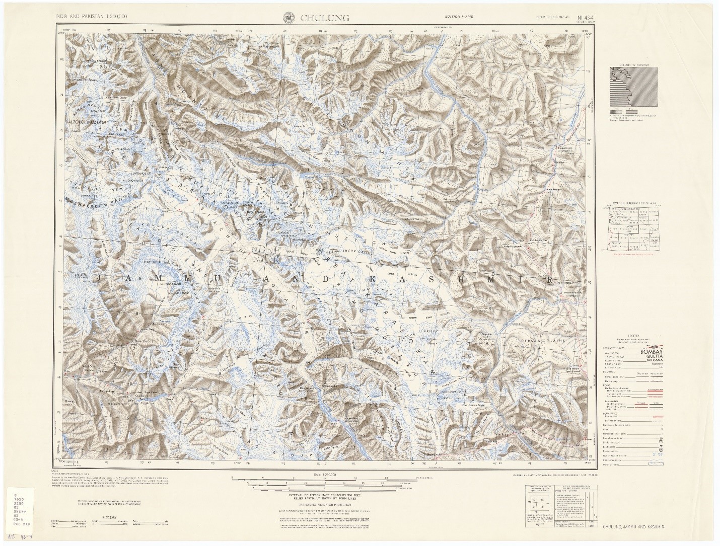
Source: US Army Map Service (AMS), Sheet NI 43-4, Series U502 India and Pakistan, AMS Topographic Series 1955, PCL Map Collection.
Stallbohm: On meeting Kumar around July/August 1977
I met with Sheikh Abdullah and gave him our application to climb Mamostong Kangri in the Rimo Muztagh and then later met Kumar in Delhi. During the encounter with Kumar, I showed him the application given to Sheikh Abdullah along with the proposed route map that we had prepared using the US Army Map Service maps (1:250 000) that we had purchased in Cologne. This piqued his curiosity. I told him it was a map compiled in 1953 by the US Army that is freely available for purchase in Germany. Later when I was home, I realised that I had made the big mistake of giving it to him as he had never seen such a map before. The project came to nothing, but the map in the hands of Kumar and others probably became the basis for the imminent conquest of the Siachen Glacier by the Indian army and an absurd conflict. In the map that I gave him, most parts of Siachen are on the Chulung Sheet,[11] and there are no annotations, remarks, or demarcation lines of any kind between India and Pakistan. So, I do not know how Kumar could use it or some mystery about the American map to justify his incursion. All other subsequent affirmations are the sole responsibility of Kumar.
Image: Route Map given by Stallbohm to Kumar showing Mamostong Kangri on Chulung Sheet (NI 43-4) and Saser Kangri Route on Shyok Sheet (NI 44-5)
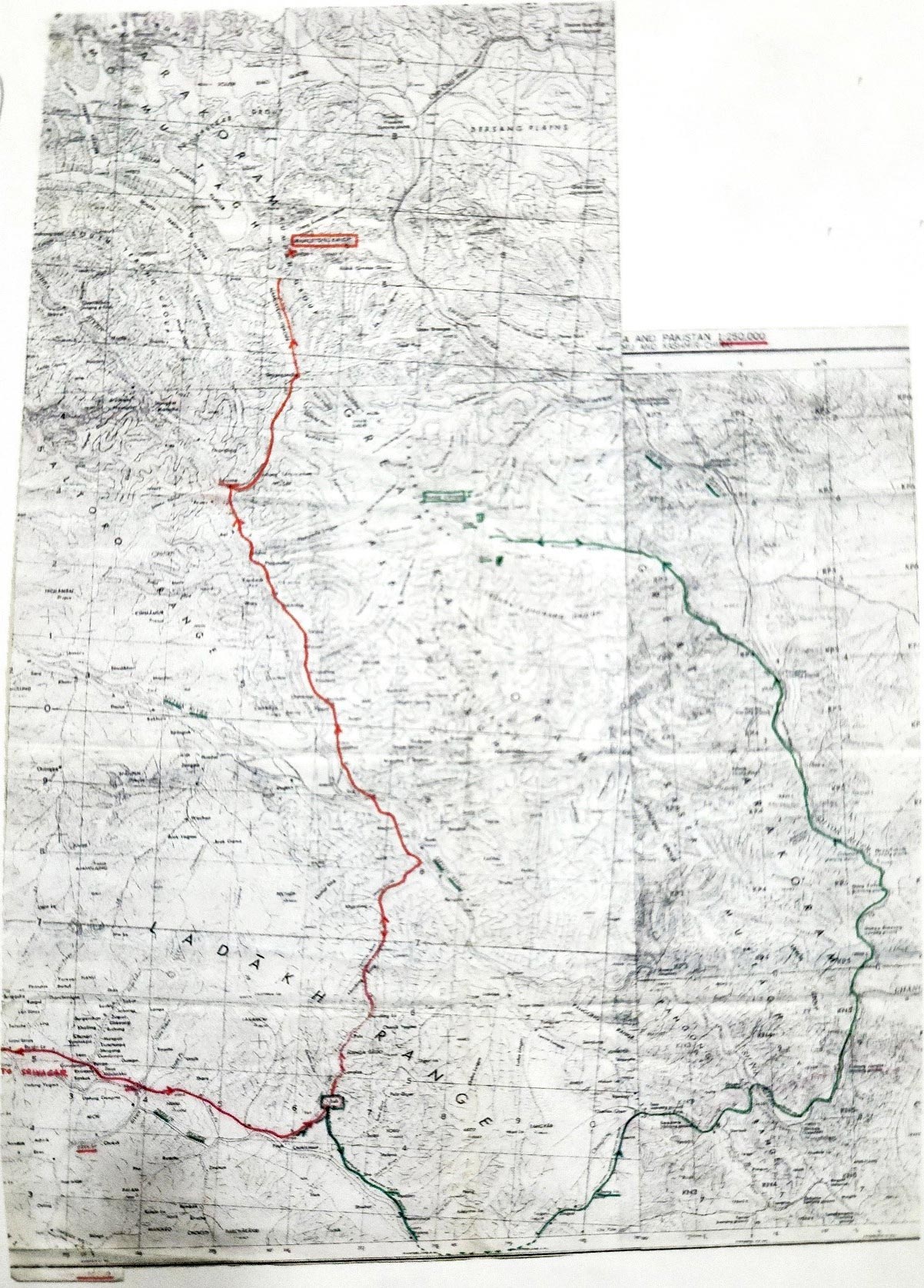
Source: Amit K Paul, reproduced with permission from Jaroslav Poncar.
Poncar: On how they ended up in Pakistan
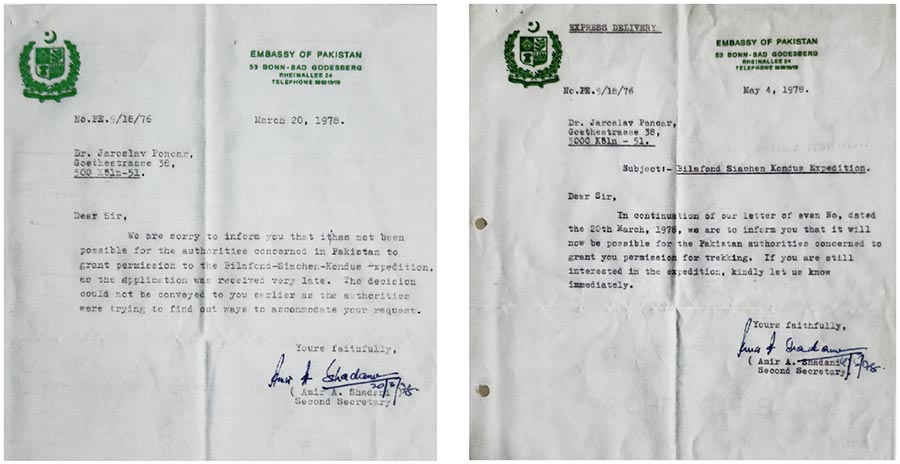
Back home, Volker was very disappointed as he did not hear from Kumar about his proposal to climb the Mamostong despite reminding him of our strong desire to go to the Nubra Valley ever since DC Mahmood’s idea of rafting on it in 1975. Around September 1977, he came to me with two reports of Japanese first ascents in Eastern Karakoram. One ascent took place in the summer of 1975 and was successful both on Teram Kangri I and Teram Kangri II, while the other reached the summit of Singhi Kangri in 1976.The joke was that all three mountains rise on the eastern side of the Siachen and the Japanese reached them from the Pakistani side following the route of the Workman Expedition by crossing over from the Bilafond and Lolofond glaciers. Volker said we should also try our luck from the Pakistani side, as the Pakistanis were much easier to deal with than the Indians. So, on 11 October 1977, we applied to the Pakistan Embassy in Bonn seeking permission for the German-Bilafond-Siachen-Kondus Expedition. We received one reply on 16 December 1977 and another on 17 January 1978 seeking particulars of the expedition team and 11 copies of the proposed route map. We submitted everything and waited until we received a letter on 20 March 1978 informing us that the permission had been denied as the application was received late. We were surprised that while the Japanese had been allowed, we were not being permitted. It was at Whitsun when I received a telegram from Islamabad: “If interested the permission for the German-Siachen-Kondus Expedition granted. Contact Pakistan Embassy in Bonn,” which was followed by a letter on 4 May 1978 telling us that the expedition had to be mounted in six weeks.
Image: Letters from the Embassy of Pakistan in Germany: Denying Permission (left) and Granting Permission (right)
Poncar: On their expedition to Siachen
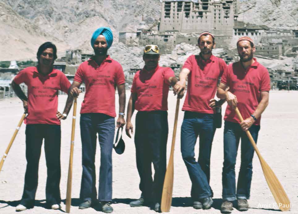
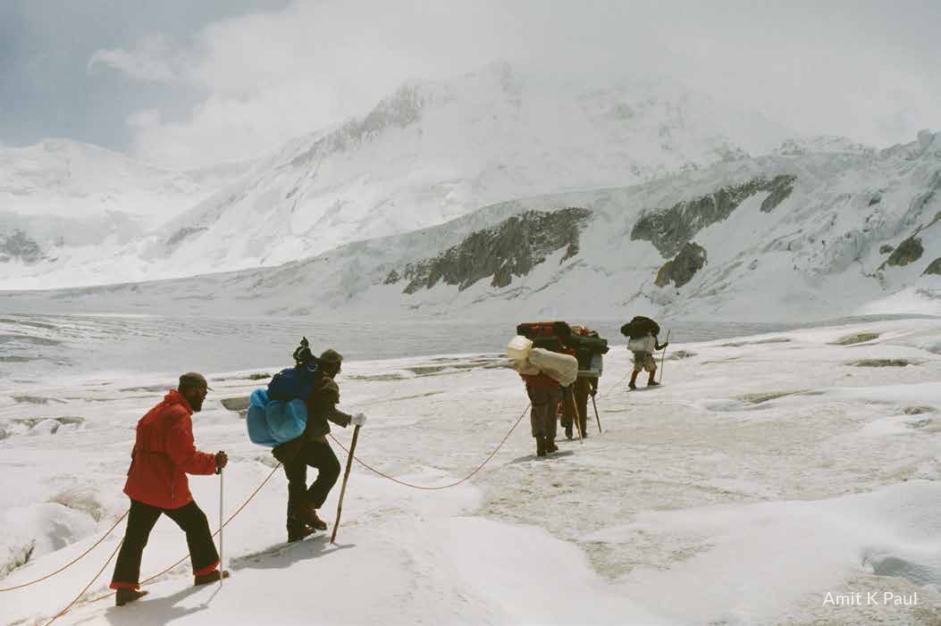
Despite the short notice, we jumped at the opportunity and, after making all preparations, reached Rawalpindi in the summer of 1978, where we stayed at the Mrs. Davies Hotel. Wolfgang Kohl accompanied us as the cameraperson. Major Asad Raza was deputed as our liaison officer by the Ministry in Islamabad. This was a stroke of great luck as he was intelligent, well-educated, and interested in the expedition. We knew from the earlier expeditions that their liaison officers just went to the base camp and were only interested in the pay and the equipment they could keep afterwards. I do not remember how much we paid for the permit but I remember that Bilafond La, the entrance pass to the Siachen, was over 17,000 feet and thus subject to fees. From Islamabad we took 10 days to reach Skardu by plane as Pakistan International Airlines’ Fokker Friendship aircraft could fly only once the Indus Valley weather cleared; it took 10 days for that to happen. From Skardu, we went to Khapalu by car. Since we were the last expedition to go to the Saltoro that year, we were besieged by several porters eager for work. Though there were only four of us, we had 500 kg of luggage, and so we hired 22 porters from Khapalu. From Khapalu our route was Surmo, where we were to cross the Shyok on a trolley, Gurtse-Huldi-Parwa-Palit to Goma, which was the last village in the Saltoro Valley before the Bilafond glacier, and then Ghyari-Chumik-Naram-Ali Brangza-Bilafond La-Lolofond-Siachen-over the Kondus glacier and then back to the Saltoro Valley.
At Surmo, the trolley that had to take us across the Shyok was broken, so we had to go back to Khapalu and get zakhs (inflated goat skin rafts). Due to heavy rains, the river was very rough and we ended up more than two-and-a-half kilometers downstream from where we had cast off. After making it to the other side, we came across another complication. The bridge on the river Hushe that was to take us into the Saltoro Valley did not exist, so we had to walk up the Hushe Valley for two days, take the bridge there, and then walk back down the same valley on the other bank.
Image: The rock feature of Ali Brangza
Source: Amit K Paul, reproduced with permission from Jaroslav Poncar.
Image: Ascent to Bilafond La
Source: Amit K Paul, reproduced with permission from Jaroslav Poncar.
Huldi to Parwa was the longest stage, and we camped at Parwa for a day. We were surprised to meet Klaus Sagaster from Bonn University at the village collecting old tales of the local inhabitants (Baltis). Finally, after 12 days of walking from Khapalu, we reached Goma, the last village before the glacier world, where a goat sacrifice was made to bring good luck to the expedition. From Goma, it was a short trek to Ghyari, which is located at the glacier tongue of Bilafond and from where the terminal moraine of the glacier starts. Navigating the moraine was a nightmare and we had to negotiate through many crevasses. After Ghyari, we set up camp at the prominent rock Ali Brangza at the foot of the ascent to Bilafond La. The next camp was established on the pass itself, where we released 14 porters and continued further with the best eight. As we descended the Lolofond Glacier, we were able to see Siachen. It looked like a 100-lane highway and even though it appeared close by, we took nearly three hours to reach it.
Image: Descent from Camp on Lolofond Glacier, Teram Kangri Group in the Background
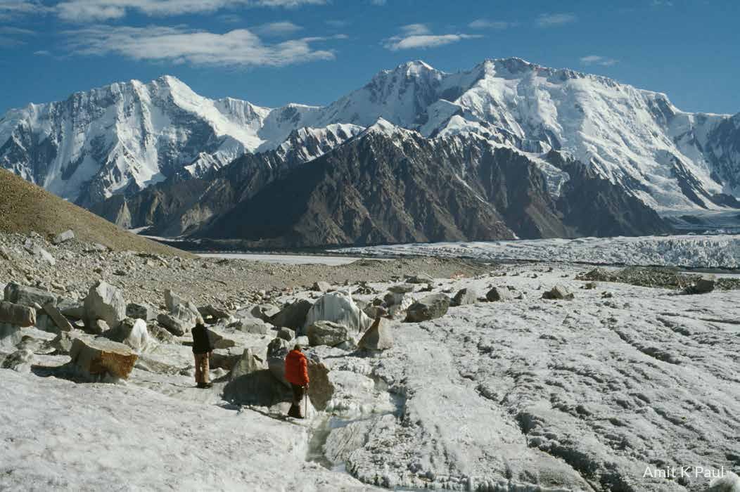
Source: Amit K Paul, reproduced with permission from Jaroslav Poncar.
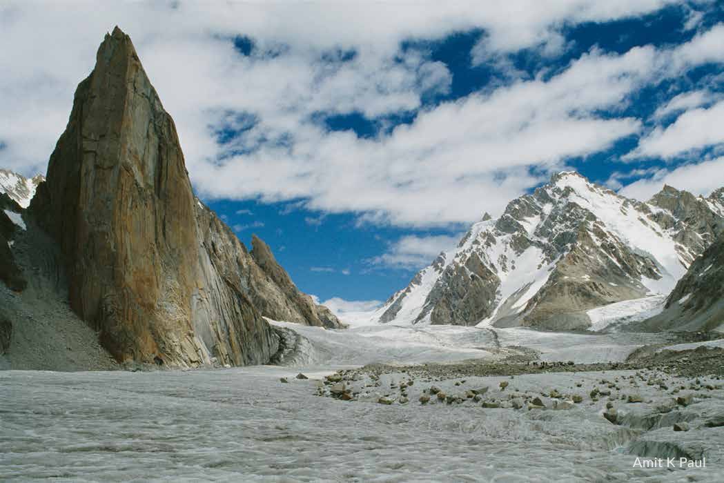
We set up camp at the confluence of the Lolofond and Siachen glaciers, opposite Teram Shehr, where we came across some luggage and skis left by the Japanese from their Singhi Kangri expedition. Opposite us, we could make out the small meadow described by Dainelli. When the sky was clear, Indian military planes flew over our base camp. Asad got very upset and said it “is our territory” (meaning Pakistan’s), to which I asked, “Who else is here other than us?” On our way between Skardu and Siachen, we saw only one Pakistani soldier, our liaison officer Major Asad Raza. Our camp could be easily reached from the Nubra Valley in Ladakh, but we saw no activity. When we had been observed by the Indian planes on Siachen, we had no idea that our expedition would become the cause of a war a few years later.
Image: In the middle of Siachen
Source: Amit K Paul, reproduced with permission from Jaroslav Poncar.
After this expedition, I made a film on the Amaranth Yatra in the summer of 1979. Then, in the summer of 1980, Indus was the subject, and we shot in Pakistan and India. On the way to Leh, I bumped into Kumar and told him about our 1978 Siachen expedition. He listened quietly and did not say a word about being on Siachen in October 1978, immediately after us. Perhaps if the DC had not told us about rafting in the Nubra, if we had not got attracted to the Karakoram, if we had not gone to Pakistan and Siachen, if we had not drawn Bull’s attention to the region, if we had not given him the map of the area, then he would have never known about it, and there may have never been a war. I do not know what Kumar did after receiving the map. Perhaps he got interested in the region because of it and did his own search. Whatever it was, it was all his own conclusion based on other maps in circulation in which the control line was extended. We and our map had nothing to do with it. If I had known what I was instigating, I would have kept quiet about it because Kumar was the warmonger on the Indian side and had only one question in his mind: Who owns Siachen? I woke up a dangerous sleeping dog. I was back in Ladakh in the summer of 1984, shortly after the war over Siachen had started. Later, I wrote to Rajiv Gandhi when he became the Indian prime minister, as well as Pakistani President Zia ul Haq to make Siachen an international sporting area instead of a soldiers’ grave.
Conclusion
From Stallbohm and Poncar’s accounts, it emerges that, despite the express mandate of the Karachi Ceasefire Agreement of 1949 requiring the status quo be maintained in the un-demarcated area beyond NJ 9842 (the northernmost demarcated point of the ceasefire line, as per the Karachi Agreement), Pakistan had been proactively permitting mountaineering expeditions in the region. Indeed, their own 1978 expedition had been overflown by the Indian military. It appears that Kumar’s interest in the Nubra Valley and the peaks of the Eastern Karakoram for mountaineering was triggered after his meeting with Stallbohm, during which they discussed everything ranging from the scuttled plan of rafting on the Nubra to climbing the Mamostong.[12] With the route map given by Volker in his hand and the idea of an ascent planted in his mind, Kumar, the mountaineer, started exploring further and dug out reports of several expeditions that had crossed the Saltoro from the west after securing permissions from Pakistan. Perhaps it is during this search that he also came across some maps in which the Line of Control had been incorrectly extended from NJ 9842 to the Karakoram Pass, thereby showing the entire area on the Pakistani side.[13] Agitated about permissions being given by Pakistan while no such permissions were given in India, and alarmed by the spate of mountaineering activity and extension of the control line in some maps, he approached the then Director Military Operations (DMO) Maj. Gen M.L. Chibber with all the information around January 1978.[14]
Since the region beyond NJ 9842 was pending mutual demarcation as per the Karachi Agreement, it did not have any military presence from either side and also did not see any action during the wars in 1947-48, 1965, or 1971. Neither side had ever formally staked claim to it or extended the ceasefire line or the LoC beyond NJ 9842 in any of their official maps. It is evident that there was no confusion inter se regarding this status of the region and no ambiguity regarding the direction in which the ceasefire line was to proceed beyond NJ 9842 (thence north to the glaciers), as none of these concerns were ever discussed or raised by either side in any forum or engagement after 1949. In fact, in 1971, when the LoC was being demarcated, both sides were focused only on the areas where there had been a conflict or some disagreement. As such, it is apparent that information about Pakistan sending expeditions beyond NJ 9842 and mountaineers approaching it for permission due to some maps incorrectly showing the entire region on its side sparked the Indian interest in Siachen around 1978. If Pakistan could permit explorations in an un-demarcated and admittedly disputed region with expeditions being accompanied by its military liaison officers, and this did not constitute any violation of the Karachi Agreement or the Simla Agreement, then there was no reason why India could also not do the same. Once all facts were ascertained and appreciated by the DMO, an Indian reaction was naturally imminent. It came as a reconnaissance mission to Teram Kangri under Kumar, which landed on the glacier within three months of the German expedition.
Thereafter, between 1978 and 1983, both India and Pakistan played a game of shadow mountaineering in the region. It is pertinent to note that, while India’s response to the Pakistani activities was limited to sending in expeditions of its own, Pakistan’s response upon detecting these Indian expeditions was completely different and caused alarm bells to ring in the Indian military establishment, setting into motion a chain of events and thus triggering the Siachen impasse. For the first time after 1949, through a written protest note,[15] not only did Pakistan formally stake claim to the entire un-demarcated region by unilaterally extending the LoC eastwards from NJ 9842 till the Karakoram Pass, contrary to the mandate of the Karachi Agreement and the Simla Agreement, but also started planning to occupy it by force. As soon as the Indians learnt about these plans, they took pre-emptive action[16] to prevent Pakistan from altering the status quo in the region to its advantage and, on 13 April 1984, established their control over the Saltoro Heights, which lie north of the glaciers from NJ 9842. Conscious of having drawn Kumar’s attention to the Siachen region and inadvertently triggering the race, today, both Poncar and Stallbohm express regret at having met him in the first place and giving him the maps. There is little doubt now that, had it not been for Kumar’s curiosity, an Indian expedition would one day have discovered Pakistan controlling the very region that India currently dominates.
Endnotes
[1] In an article in Dawn (30 June 1986), Brig (Retd.) A.R. Siddiqui wrote: “Even between India and Pakistan, through their three wars (1947-48, 1965, 1971) Siachen did not even remotely figure as a controversial point. In fact except for personnel of the military operations branch and mountaineers, most of us had not even been aware of its existence...”
[2] The first demi-official article on this subject in Pakistan was written by a military observer (‘Siachen Glacier: Facts and Fiction’ that appeared in Dawn on 6 September 1986). It clearly mentions that “…the portion of the CFL beyond KHOR was not demarcated due to the inaccessible glaciated nature of the terrain. It was then mutually decided by both the countries that this portion of the CFL would be demarcated later, on the basis of the 1949 Agreement by the local commanders assisted by the UN Military Observers……. The area being disputed, no Pakistani troops were placed in Siachen Glacier area in consonance with the provisions of the Karachi and Simla Agreements”. On similar lines, while discussing the status of the region beyond NJ 9842, Gen. Khalid Mahmud Arif (Retd) wrote in an article (‘India’s Siachen Adventure’ that appeared in Dawn, 21-22 May 1989): “This portion of the CFL was to be demarcated in detail on the basis of the factual positions as of July 27 1949 by the local commanders assisted by the UN Military Observer. The demarcation has not taken place till today. It was not done at the time of signing of Karachi Agreement primarily for two reasons- inaccessibility of the area due to its glacial nature and absence of any fighting there because neither India nor Pakistan had troops deployed in the region. The military representatives had confined their agreement to the area of actual hostilities.” Later, in his book Working with Zia (1995, p 223), he confirms that “The demarcation of the cease fire line was completed up to the terminus point NJ 9842 (edge of the Siachen Glacier area) on the basis of the factual position as of July 27 1949. The demarcation beyond the terminus point was left to be done subsequently and has not yet taken place. The Siachen Glacier area thus remained free from the troops of either country. This status quo was not disturbed during the Indo-Pakistan wars of 1965 and 1971.”
[3] Perhaps the earliest mainstream article on the possibility of mountaineering activities being used to alter established territorial boundaries was written by Joydeep Sircar when he detailed the explorations that had taken place in the region in an August 1983 article in The Telegraph (‘High Politics in Karakoram’, 6 August 1983), followed by another piece on 23 June 23 1985 (‘Who is on thin ice?’). In his article published in the Himalayan Sameeksha and reprinted in the Alpine Journal of London in 1984 ("Oropolitics: A dissertation on the political overtones of mountaineering in the East-Central-Karakoram, 1975-1982"), Sircar, while referring to the mountaineering activities in the region, opined, “While these ascents may not have made mountaineering headlines (reserved for big name peaks and climbers), it is impossible to believe that nobody at New Delhi noticed what was going on. I have no doubt that these ascents were viewed with gravity insofar they revealed an insidious Pakistani attempt to display to Western Observers their control over the Siachen basin.” On the contrary, it is submitted that no one in Delhi or elsewhere was keeping a close watch on the pattern of explorations taking place in this vast demilitarised region until everything was pieced together from various journals after being flagged by Kumar in 1978. This has been subsequently confirmed both by Lt. Gen Chibber and Kumar. In fact, other than their protest notes of the early 1980s, even on the Pakistani side, there is no contemporaneous evidence to show that it used the factum of these explorations to its advantage to assert any territorial claim beyond NJ 9842 or show this territory as its own in any of its maps. This argument emerged in the Pakistani media only after the Indian occupation of the Saltoro Heights on 13 April 1984 and some of its proponents relied upon Sircar’s list of explorations to make their case (See, Zulfikar Ali Khalid, ‘Geopolitics of the Siachen glacier, Asian Defence Journal,11/85). It is pertinent to note that, in 1958, a Geological Survey of India team conducted a detailed snout survey of the Siachen Glacier (See, Amit K Paul, “The first GSI Survey of the Siachen,” The Hindu, July 13, 2023, https://www.thehindu.com/news/national/the-first-gsi-survey-of-the-siachen/article67077315.ece). Though this was a well-publicised expedition, there was no reaction to it from the Pakistani side. It emerges that none of the explorations from either side elicited any reaction from the other as at no point in time did either side make any attempt or demonstrate any intent of physically occupying the region, which was admittedly pending mutual demarcation as per the Karachi Ceasefire Agreement of 1949
[4] In a 2010 essay (‘Siachen Glacier Political and Geostrategic Dimensions’), Hasan Askari Rizvi wrote: “….the Siachen Glacier surfaced rarely in the security discourse in Pakistan and India before 1984 with the exception of some official statements in the late 1970’s sand the early 1980’s. Most published works including newspaper reports on the Siachen Glacier appeared after April 1984. Once India moved its troops into the glacier area, a rationale had to be articulated. Pakistan built its argument to counter India’s claim and assert that historical evidence supported Pakistan’s claim on the area. These arguments could be described as after thoughts or ex post facto rationalizations.”
[5] Based on in-person interviews with Jaroslav Poncar conducted on 13 August 2023 and 24 August 2023 at New Delhi, numerous e-mail interactions with Poncar and Volker Stallbohm, and Poncar’s self-published accounts of the Indus Expedition (1975), the Zanskar Expedition (1976), and The Siachen Expedition (1978). After clarifying some typographical errors and inconsistencies in these accounts, Poncar permitted the author to reproduce their excerpts with images to supplement the discussions.
[6] In all accounts attributed to Kumar, there is a reference to a map given to him by the Germans in which the LoC has been extended to the Karakoram Pass and the region incorrectly depicted on the Pakistani side. See, for instance, Colonel Narender ‘Bull’ Kumar and Prateek Joshi, “Siachen Glacier: The fulcrum of the great game: Colonel Bull Kumar’s perspectives,” Asian Affairs, 2018, Vol XLIX, no 1, p 110: “On one of these missions his eye caught a map of Jammu and Kashmir used by a German expedition team. To his astonishment, the map showed the entire Siachen region within Pakistani territory”. Also see, Colonel N. Kumar with Colonel N.N. Bhatia, Soldier Mountaineer (India: Vij Books, 2016, p 192): “Taking one look at the map Bull knew there was a cartographic error”. Also see, “The Story of How the Siachen Glacier was Won: As told by Narendra Bull Kumar,” Times Now News, 16 January 2019: “When they returned they brought with them a map which was published by the Americans….what they had done is that they had drawn back the map to the Karakoram Pass giving 10,000 sq km to Pakistan”.
[7] Tom Longstaff was a British explorer who reached the Siachen Glacier in 1909. From Srinagar, he travelled to Khapalu and crossed the Saltoro Ridge at Bilafond La before descending to the glacier.
[8] Fanny Bullock Workman and William Hunter Workman were an American explorer couple who followed Longstaff’s steps in 1911 and returned in 1912 to reach Siachen using a similar route. For more, see: Harish Kapadia, Siachen Glacier: The Battle of the Roses (New Delhi: Rupa, 2010)
[9] Giotto Dainelli was an Italian explorer who reached the Siachen Glacier from the Nubra Valley in 1930. For more, see: Professor Giotto Dainelli, “My expedition in the Eastern Karakoram, 1930,” The Himalayan Journal Vol. 4, 1932, https://www.himalayanclub.org/hj/4/4/my-expedition-in-the-eastern-karakoram/
[10] US Army Map Service (AMS) Corps of Engineers, Map Sheet NI 43-4 Series U502, titled India and Pakistan, 1;250,000, Chulung Sheet, compiled in 1953 from Quarter Inch Series 1: 253 440 Survey of India Map and published in the 1st Edition of the India and Pakistan AMS Topographic Series, 1955. There are similar map sheets in the same series bearing numbers NI 43-8 for Leh and NI 44-5 for Shyok. The route map has been prepared using all three sheets. None of these maps show any demarcation between India and Pakistan. For more, see Perry Castaneda Library (PCL) Maps Collection, University of Texas at Austin.
[11] According to Stallbohm, this route map with the Chulung sheet showing Mamostong on the Chulung sheet was given to Kumar.
[12] The author interacted with Narinder ‘Bull’ Kumar on 10 April 2018, 13 April 2018, and 11 February 2020 in person and probed him about the maps that aroused his curiosity in 1978. During the discussions, Kumar vividly recalled the Indus Expedition, his association with the Germans, and his meeting with Stallbohm. He also recalled taking a map from Volker, searching for details on expeditions coming into the Siachen region, stumbling across some maps showing a line going towards the Karakoram Pass from NJ 9842 and then handing over everything to the DMO. However, he did not remember which specific map(s) he handed over to the DMO or the contents of the map given to him by Volker. Based on his stated position, this author also wrote an article (‘Kumar’s Line versus Hodgson’s Line,’ The Print, December 31, 2021, https://theprint.in/opinion/kumars-line-vs-hodgsons-line-the-lakshman-rekha-that-started-an-india-pakistan-fight/791557/). However, the search for the elusive map continued till Poncar and Stallbohm filled in the blanks. Research thus far suggests that Volker met Kumar for the Mamostong Kangri Expedition and gave him the route map that he had prepared with the Chulung sheet. Being a mountaineer, Kumar was fascinated as he had never seen it before. That map, in Kumar’s possession, acted as a catalyst for his further probes, during which he discovered details of expeditions coming in from the Pakistani side and maps extending the control line to the Karakoram Pass. Since everything happened in close succession, it appears that while recalling the facts many years later, Kumar inadvertently attributed the cartographic error to the map given by Volker.
[13] During this period, several maps in circulation visually extended the LoC to the Karakoram Pass by joining these two points in a straight line. These included, inter alia, US State Department maps, US Tactical Pilotage Chart TPC-G7D, US Operational Navigation Chart ONC G-7, and maps published in some atlases. Any of these could have caught Kumar’s attention while making his enquiries and further passed on.
[14] Lt. Gen. M.L. Chibber, “Siachen: The Untold Story (A Personal Account),” Indian Defence Review, Vol. 5, 1 Jan-March 1990, https://www.indiandefencereview.com/spotlights/siachen-the-untold-story-a-personal-account/
[15] “Siachen: The Untold Story (A Personal Account)”
[16] Jahan Dad Khan, Pakistan Leadership Challenges (Oxford: Oxford University Press, 2001), p 226; Pervez Musharraf, In the Line of Fire (New York: Simon and Schuster, 2006), p 68; Shuja Nawaz, Crossed Swords: Pakistan, its Army and the Wars Within (Oxford: Oxford University Press, 2008), p 508.
The views expressed above belong to the author(s). ORF research and analyses now available on Telegram! Click here to access our curated content — blogs, longforms and interviews.

 PDF Download