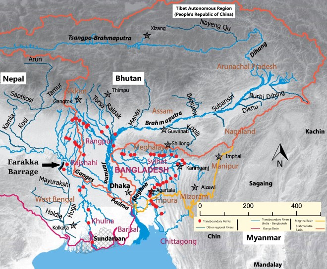
Bangladesh and India share 54 rivers including the Ganga, Brahmaputra and Meghna (together known as the GBM river system) which have created the fertile GBM river delta – the largest in the world. With an area of approximately 150,000 km2 and covering two-thirds of Bangladesh and parts of the West Bengal state of India, the delta is the largest of its kind in the world, and is home to around 130* million inhabitants. It is for this reason that Bangladesh is often referred to as a riverine country whose landscape, culture and even identity have been shaped by its rivers. The Brahmaputra and the Meghna (or Barak as it is known in India), along with their tributaries, have remained largely unregulated and consequently attracted little contention in the past, but the same cannot be said for the Ganga.
A look back
The oldest infrastructure on the mainstream of the Ganga – the Bhimgoda barrage, was constructed in 1854 to serve as the headworks of the Upper Ganges Canal. It still stands to this day as a testament of colonial hydrology for transforming the agrarian landscape in the basin. However, it was more than a century later, that the commissioning of the Farakka Barrage in 1975 triggered strong resentment in the downstream which now constituted an independent nation in Bangladesh. The implications of reduced flow in the downstream of the barrage and the insecurity regarding lean-season flows started generating ripples of discontent. This was epitomised by Maulana Abdul Hamid Khan Bhasani’s Farakka long march on May 16, 1976. The march continues to be commemorated to this day as a momentous feat that could be achieved by Bhasani in trying to galvanise public opinion in Bangladesh against the barrage.
The 1970s witnessed the Farakka issue being catapulted to the centre stage of Bangladesh’s foreign policy vis-à-vis India. Bangladesh would subsequently go on to forge one agreement (1977) and two Memorandums of Understanding (in 1982 and 1985), but they only provided the country with temporary relief. It was not until 1996 that instead of ad-hoc arrangements, a proper water-sharing agreement could be stitched between India and Bangladesh, which is still hailed as the next major achievement in water sharing in the subcontinent since the Indus Waters Treaty of 1960. It can be argued that the Ganges Water Sharing Treaty has met with success in dispelling the then-prevailing concerns of Bangladesh. However, in the meantime, new concerns have also emerged which need to be accounted for in the new framework for cooperation with the expiry of the existing treaty in 2026.
Enumerating the concerns
The concerns pertain to two specific issues – projected impact of climate change in the region and the need for a holistic agreement based on the tenets of Integrated Water Systems Governance. It has been pointed out that the major limitation of the treaty was the unjustified assumption of future water availability at Farakka based on 40-year average flows. Climate variability is stated to increase along with increased water extractions in the upstream of Farakka resulting in acute low flow during the most critical pre-monsoon period. Similarly, when the agreement was reached, there was very little understanding of the water system since the entire paradigm was that “a river goes waste into the sea”. More recently, there has been a call for an interdisciplinary perspective to view rivers not merely as cubic metres of water flow but also consisting of water (together with diverse dissolved materials), as well as energy and sediments among various other constituents and which, in turn, support a great variety of habitats and biodiversity.
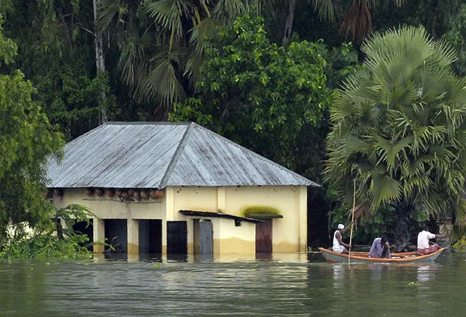
Structural interventions and reduced river flow have also resulted in disturbed habitats and loss of fish diversity. Moreover, the ecological environment of Bangladesh’s south-west is dependent on the interaction between freshwater supplied by the Gorai-Madhumati channel – a distributary of the Ganga, and the saline water from the Bay of Bengal. In the absence of sufficient freshwater due to the diversion, the salinity has increased in the region adding significant constraint on the growth, survival and regeneration of major mangrove plants and impacting livelihoods as well. The Ganges-Kobadak Irrigation Project has also remained underutilised due to the low flows in the Ganga during the dry season, thereby impeding Bangladesh’s effort to increase food production to support its ever-increasing population and managing with limited land availability for growing food grains.
The cruciality of sediments
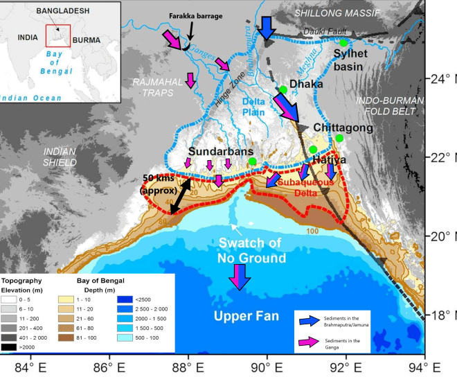
Not just water, but sediments also get trapped behind walls of concrete. The build-up of sediments has led to drainage congestion in the upstream and increased risk of backwater flooding. In the downstream, it poses a challenge for the sustenance of the delta and its ecosystem. This peculiar crisis has in a way brought Bihar and Bangladesh on the same side while West Bengal fiercely battles it out in defence of the barrage that is essential for ensuring the navigability of Calcutta Port and the supply of water to the large and dense urban settlements along the Hooghly river. This also highlights a trade-off between the provisioning services of river flow along the Hooghly with the supporting services along the Ganga/Padma in Bangladesh.
It has been estimated that the sediment load in the combined flow of the Ganga and Brahmaputra is decreasing at a rate of 4-10 MT/year. From a previous estimation of mean annual sediment load of 1.0 to 2.4 billion tonnes per year, the sediment load in the GBM system had declined to 500 million tonnes per year in 2015. However, as of now, this is still sufficient to offset the combined effects of land subsidence and sea-level rise but the unsustainable practices in the upstream could soon push the balance beyond a certain threshold. A reduction in the supply of sediments also has severe implications for soil formation and nourishment of top-soil – a supporting service of the riverine ecosystem in the GBM delta that had been instrumental in making Bangladesh an agricultural powerhouse.
For a post-2026 arrangement, it is important for the countries to not get stuck in the binary of choices of either keeping or dismantling the Farakka barrage. The Indian government continues to envisage a pivotal role for the barrage in the days to come by identifying it as an all-important node in Inter Basin Water Transfer – connecting the Himalayan component with the Peninsular one (via River Link 13 and 14). The interlinking project itself is questionable, but it is likely that India would strongly defend the barrage in the times to come. At the same time, it is also fair to expect that it would be sensitive to the demands of Bangladesh that has now granted its rivers the status and rights of ‘living entities’. Therefore, the complexities involved demands a more nuanced understanding and a shift from the linear approach of considering binaries. It is important to be mindful of the intervening factors which may push the countries either to a path of conflict or cooperation. This can then be followed up with effective policies domestically and holistic arrangements regionally to temper or amplify the influence of such factors depending upon the desired outcome.
This commentary originally appeared in Water Science Policy.
The views expressed above belong to the author(s). ORF research and analyses now available on Telegram! Click here to access our curated content — blogs, longforms and interviews.