Sustaining urban growth through ecological restoration: The case of Coimbatore
A city goes through several stages of evolution from being an aggregate of activities and population to developing its own identity as an economic and cultural hub. In the context of urban management, the evolution of a city is seen in its ability to think for itself in terms of resource sustainability and dynamic infrastructure needs. Coimbatore, the second-largest city in the state of Tamil Nadu, has gone through various stages of economic evolution: from being an agro-processing industrial zone to an electrical and automobile hub, and further to the educational and information technology hub that it is today. Such changes have had an impact on the spatial growth and development of the city. The city is one of the “lighthouse cities” in the ‘smart city mission’ started by the government in 2015, having been selected in the first stage of the competition.[1]This report examines the key aspects that concern sustainable development efforts in Coimbatore. It highlights the need for ecological sensitivity in urban planning and development mechanisms to ensure long-term sustainability of the city.
INTRODUCTION
Coimbatore is the 15thlargest Urban Agglomeration (UA)[2]in India and the second-largest city in the state of Tamil Nadu.[3]Among India’s major states, Tamil Nadu is one of the most urbanised, with 48 percent of its population living in urban centres.[4]Tamil Nadu is also a progressive state, with high levels of economic and social development. Not only is it the most urbanised state, but it also has a better spread of urbanisation. Compared to the two other highly urbanised states in the country—Maharashtra and Gujarat—Tamil Nadu has a larger number of towns per unit area, and a better mix of small, medium and large towns with a better spatial spread of these towns.[5]
Tamil Nadu has been one of the first to implement urban reforms in the country. The initial set of reforms in the city were aimed at leveraging international funding for infrastructure development and making the Urban Local Bodies (ULBs) more creditworthy through improvements in accounting and the introduction of a pooled finance scheme for ULBs to borrow for infrastructure development. The reforms in Tamil Nadu go back over three decades, to the entry of the World Bank into funding for the urban sector in the mid-1970s. The series of projects initiated include the Madras Urban Development Projects 1 and 2, Tamil Nadu Urban Development Projects I and II, and the Tamil Nadu Urban Development Fund. These projects included components for institutional strengthening of state agencies and ULBs to help improve urban service delivery and governance.[6]
With such a strong base of a growing urban population, improved infrastructure provision, and the presence and experience of dealing with multilateral funding agencies, it can be said that the Urban Local Body of Coimbatore is at a higher level of development compared to many other states and cities in India. However, this same growth and development have resulted in newer challenges. This report focuses on the present-day challenges to sustainable urban development in Coimbatore. It begins with an overview of the city, and proceeds to identify and position the key urban management aspects in present-day Coimbatore. The report discusses specific issues such as spatial expansion, and population growth and its impacts on the urban environment and infrastructure provision. It then describes the efforts of the city and the state government in tackling these urban management issues, in particular those related to smart and innovative solutions included in the ‘smart city’ proposal. The report concludes by identifying the key areas that merit further focus for the sustainable development of Coimbatore.
COIMBATORE CITY: AN OVERVIEW
Coimbatore is located on the banks of Noyyal, a seasonal river. The city is an important economic centre in Tamil Nadu and has one of the highest gross district domestic product. The textile and light engineering industry located in Coimbatore accounts for two-thirds of India’s total capacity. It has the second-largest software exports centre in the state and houses leading IT service providers including Cognizant and IBM. The city has a strong ecosystem for entrepreneurship, with five incubation centres promoted by city-based higher-learning institutions.[7]
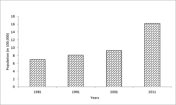
The city used to rely primarily on its textile industry. Many manufacturers gradually moved to the neighbouring district of Tiruppur, and Coimbatore moved up the value chain by diversifying into other sectors such as automobile, electrical, dyeing and heavy machines. Recently, the city further diversified into the tertiary sector by becoming a major centre for IT and software industries. It has also emerged as an important centre for education.[8]Coimbatore has, therefore, become a sought-after destination for those looking for employment and education, and has witnessed a high population growth in the last four decades (Figure 1). The population growth in the city was 29.3 percent during 2001–11 (including the areas added during the expansion of city limits in 2011). In response to the increasing population, the density of population continually witnessed an increase from 1981 to 2001 from 67 to 88 persons per hectare (PPH). The population of the Coimbatore UA is 21 lakh as per Census 2011.
Figure 1: Decadal Change of Population in Coimbatore
Data Source: Coimbatore Municipal Corporation, 2015.[9]
In 2011, the Coimbatore City Municipal Corporation (CCMC) boundary was expanded from 105.06 to 257.04 sq. km by merging three municipalities, seven townpanchayatsand one villagepanchayat. The CCMC is divided into five zones—North, South, East, West and 100 wards—for administrative purposes.[10]The increase in area has meant a decline in overall density of population to 63 PPH in 2011. The following sections detail the implications of the expansion of area on key issues such as resource sustainability and infrastructure provision.
POSITIONING URBAN MANAGEMENT ASPECTS OF COIMBATORE
Spatial Expansion and Growth
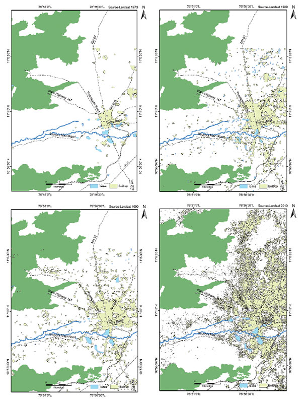
The spatial expansion of urban areas in and around Coimbatore city has been tremendous in the past decades due to increasing diversity of economic activities. In the sphere of economic activities, the city has constantly improved itself by keeping up with globalisation and liberalisation trends in other parts of the country. Thus, there has been increasing spatial expansion of the urbanised areas across the city. To ensure harmonious development of these expanded areas, the CCMC limit was expanded. The city has seen expansion in urban growth along the main arterial roads leading to Sathyamangalam, Metupalayam, Avinashi, Trichy, Cochin, and Palakkad; and along the peripheral areas of Singanallur, Ondipudur, Matuthamalai, Seeranayakanpalayam, Kumarapalayam and Vilankurichi, located close to the forest area.[11]Figure 2 shows the spatial expansion of the city from 1973 to the present. The urban area growth is more noticeable in the 1999–2010 period. Such rapid spatial expansion has had a profound impact on the natural environment, infrastructure provision and liveability. This is discussed in the subsequent sections of this report.
Figure 2: Spatial Expansion of Coimbatore Urban Area
Coimbatore, and Tamil Nadu in general, have had many infrastructure development programmes supported by the central and state government and international funding agencies.[13]The CCMC has been implementing several infrastructure programmes under the Atal Mission for Rejuvenation and Urban Transformation (AMRUT) scheme of the GoI. The city is well ahead in planning for expansion of services and detailed project reports have been prepared. However, there are infrastructure deficits in the newly added areas, where implementation of infrastructure improvement schemes is required. The key issues with respect to infrastructure provision include the following:
Improvements in sanitation and sewerage systems:About 7.5 percent of the households of Coimbatore do not have access to toilets, and 20 percent of the households do not have safe disposal facilities for liquid waste. In the absence of these, sewage discharge into natural water bodies is quite rampant. The treatment of waste water assumes immense importance in such a scenario. There are many eco-friendly ways of treating waste water. These mechanisms are not just cost effective, they also do not require extensive treatment facilities. The eco technology can be used at three levels: river restoration, water and waste water treatment, and lake restoration. The eco-friendly technologies use plants, natural coagulants, microbes and earthworms in the treatment process. The Vetiver technology is one such example of an eco-friendly treatment process. For waste water treatment, vermiculture can be an effective treatment mechanism. The EMAS (Effective Microorganisms Activated Solutions) technology, too, has been used in many countries to clean rivers.
Drainage network:The city has an extensive drainage network with three levels of drains. The Noyyal, a seasonal river, is the primary drain. There is major natural irrigation-cum-drainage channel that extends for a length of 54.42 km. All the drains culminate into nine major water bodies. Most of the drains are covered with weed growth and the drainage courses are encroached with hutments. While the CCMC maintains the tertiary drains that are connected to the natural channels, these too are silted and filled with weed growth.
Traffic congestion:The major arterial roads of the city that have seen spatial growth also face traffic congestion. The city has already prepared the city mobility plan to address the issues related to traffic congestion.
Green spaces:Due to increasing population, the built-up area in the city has increased tremendously (the typology of built-up areas and its impact on urban micro-climates is discussed in the subsequent sections). The present open space availability is only 1.12 sq. m per capita (vis-à-vis the norm of 10–12 sq. m per capita).
Infrastructure situation in extended areas:The city faces the difficult task of providing infrastructure in the newly extended areas: water supply pipe networks and underground drainage networks are missing in many areas.[14]
Environment and Climate Change
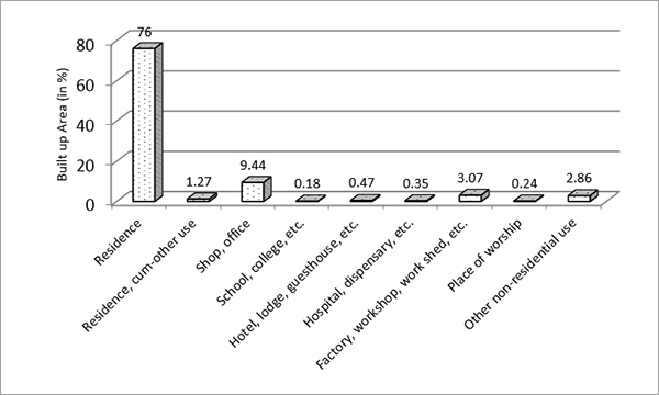
Coimbatore is surrounded by the Nilgiri Biosphere Reserve in the north and the Anaimalai and Munnar mountain ranges in the east, all of which form the Western Ghats, one of the “hottest” biodiversity hotspot regions of the world.[15]As the city’s urban population grows, it leads to an increase in the areas being converted for urban land use and built-up space. Figure 3 shows the classification of the built-up area in the city. Of the built-up area, 76 percent is exclusively for residential purposes. The situation impacts on the city environment and its surrounding region in these ways:
Creation of urban heat islands[16]that increase heat and humidity:There is a need to look for improved urban design and building typologies that reduce the impact of such heat islands.
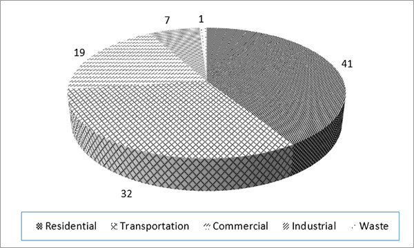
Increased pollution due to high levels of carbon emissions:Figure 4 shows carbon emissions for each sector. The residential sector alone contributes to 41 percent of the total carbon emissions in Coimbatore, followed by the transportation sector that contributes 32 percent.
Increased pressure on water and land resources:This causes groundwater depletion, waste dumping, and silting in natural drains and lakes.
Figure 3: Classification of Built-Up Area in Coimbatore
Note: Numbers mentioned in Figure 4 are percentages.
CITY GOVERNMENT AND CITIZEN INITIATIVES FOR SUSTAINABLE URBAN MANAGEMENT
Local Governance Reforms
In Coimbatore, reform processes began much before they did in other parts of the country. The process continued during 2005–12, under the Jawaharlal Nehru National Urban Renewal Mission (JNNURM), when key urban governance initiatives were undertaken. E-governance initiatives have been some of the most important achievements of the CCMC. The city won the “Best Government to Citizen (G2C) Website 2012” award for cities between 1–2 million population categories in the inaugural Janaagraha Urban G2C Awards 2012, supported by the Ministry of Urban Development, now the Ministry of Housing and Urban Affairs. CCMC’s website gives comprehensive information on all major aspects such as infrastructure, services and projects; administration and elected representatives; statutory and financial information (accounts, budgets, RTI compliance); reports and documents (city-level plans, master plans, and others); and the latest updates.[19]The CCMC plans to launch a mobile app for the seamless extension of citizen application services, especially for grievances, onto smartphones.[20]
There is a need for continuous capacity building at the municipal level to help the municipal administrators at all levels understand the subtle nuances of complex urban phenomena. The constant evolution of the programmes for urban development (as in the case of the JNNURM and the smart city mission) requires understanding of the project dimensions and their implementation. The Tamil Nadu Institute of Urban Studies, located in Coimbatore, conducts various training programmes for the same.
Sustainable Urban Management Initiatives
The CCMC has undertaken several initiatives to improve urban service provision. Some of the initiatives include:
Decentralised waste management, wherein a zone-level waste collection and segregation centre has been established. These centres also undertake decentralised waste composting. There is 100 percent door-to-door collection of waste in all the wards of the city, of which 50 percent is source segregated. The CCMC has won the prestigious SKOCH award for this initiative. A biomethanation plant of 11 MT-capacity is operational, and the energy generated is used for lighting.
The corporation has taken steps to increase the use of non-motorised transport (NMT), for which it won an award for Non-motorised Sundays at Urban Mobility India Awards 2015. A comprehensive mobility plan for the city has been prepared, and its implementation is underway. The bus system in Coimbatore supports over 40 percent of the motorised passenger trips in the city.
The corporation has exchanged knowledge and experiences in renewable energy and energy efficiency strategies with the cities of Ekurhuleni (South Africa) and Yogyakarta (Indonesia) as part of the “Local Renewables Model Communities Network,” facilitated by the city network ICLEI–Local Governments for Sustainability.[21]
Apart from dealing with spatial expansion and infrastructure provision in the extended areas, it is important to reconfigure the city core. Coimbatore’s core is congested, and many of the erstwhile industrial areas need redevelopment. There is a need to create open spaces and open up bottlenecks that lead to congestion and degeneration of quality of life in the urban areas. There is a need for innovation and forward thinking in the design of open spaces in urban areas, which should vary in their scale and typology based on the characteristics of the particular city core. Similarly, decisions on building typology and use, too, need an innovative approach, wherein live-cum-workspaces can be created and old industrial spaces can be repurposed. Given the dynamic economic environment of Coimbatore, collaborative or shared workspaces (which may be especially relevant for start-up firms) can be considered.
Smart City Plan Initiatives
The smart city proposal submitted by the CCMC received widespread acclaim for its focus on its natural environment and identification of smart, integrated, technology-oriented and citizen-centric solutions. Some of the important proposals that address the critical problems of the city in an innovative and integrated manner include:
Rejuvenation of its water bodies:The city has eight lakes and the smart city plan proposes the eco-restoration of these lakes, connecting its canals and providing green pathways for cycling and walking along the lakes. The city is conducting an inventory of its water bodies and preparing a detailed project report.
Smart Road Development:Walking constitutes around 20 percent of all travel in Coimbatore. Therefore, there is considerable emphasis on improving pedestrian facilities. A plan for a network of “Complete Streets” has been prepared for a length of some 49 km. The key features include high-quality walking and cycling facilities, improved access to public transport, organised parking and vending zones, and streamlined junctions. This should improve walkability, safety of pedestrians and cyclists, public transport ridership, parking facilities, junction geometrics, and public amenities including accessible vending zones.[22]
Citizen Participation
Citizen participation in preparing the smart city proposal was one of the major USPs of the smart city plan. There have been extensive citizen discussions and participation through mobile apps as well. The city, during the preparation, introduced the “Shape Your Coimbatore,” which resulted in relevant contribution from the grassroots. Besides this, NGOs such as Siruthuli have done considerable work on lake desilting, mobilising the community for waste management, and other activities.
CONCLUSION
The Coimbatore city government and its citizens have shown remarkable ability in addressing and tackling urban problems at their roots. Initiatives such as restoration of lakes and linking of canals as part of the smart city initiative will not only help the city, but help improve the environmental situation of the entire region. Apart from these, some other important aspects to consider include the following:
A comprehensive assessment of the environmental situation, especially with respect to groundwater availability, surface water quality, and mapping of natural water recharge areas and channels. This is necessary primarily because the city and its region fall in an environmentally sensitive area.
A review of the planning and development regulations with respect to their applicability in the extended areas of the CCMC. Currently, the growth is largely haphazard and ungoverned. Policies and regulations for building construction, green cover, industrial operations, water use, waste management, and other issues, need to be carefully framed and enforced to ensure a harmonious and balanced urban growth.
The study of mobility patterns across the newly added areas, other parts of the Coimbatore district, and other cities in the region, including Palakkad and Tiruppur. Mass transit options will enhance regional mobility, which will also ultimately help reduce the congestion in Coimbatore.
ABOUT THE AUTHOR
Anuradha Yagya is an alumna of the School of Planning and Architecture, Delhi. She works as an independent development consultant.
ACKNOWLEDGEMENTS
This report is an outcome of a collaborative workshop on smart cities organised in Coimbatore on 6–7 June 2017 under the umbrella of the German House for Research and Innovation by Heidelberg Centre South Asia and the Observer Research Foundation, in partnership with the Bavarian-Indian Centre, School of Planning and Architecture Delhi, and the Coimbatore Chapter of Indian Institute of Architects. The workshop, second in the series after the first one in Shimla, was held in collaboration with local institutions, namely, the PSG College of Technology and Kumaraguru College of Technology. This publication is supported by the Friedrich Naumann Stiftung für die Freiheit.
The author is grateful to the Commissioner of Coimbatore City Municipal Corporation, Dr. K. Vijayakarthikeyan; other distinguished workshop speakers; and the participants for sharing their valuable experiences. For their insightful comments on the manuscript, thanks are also due to Dr. Rumi Aijaz, Senior Fellow, Observer Research Foundation; and Mr. Radu Carciumaru, Resident Representative, Heidelberg Centre South Asia, German House for Research and Innovation.
ORF’s partner organisations in this research:
Endnotes
[1]The first stage of the smart city mission competition selected 20 cities for smart city funding on the basis of the strength of their smart city proposal. Coimbatore ranked 13thamong the 20 selected cities.
[2]As defined by the Census of India, an Urban Agglomeration is a continuous urban spread constituting a town and its adjoining outgrowths (OGs), or two or more physically contiguous towns together with or without outgrowths of such towns.
[3]Census of India, 2011, http://www.census2011.co.in/urbanagglomeration.php.
[4]Census of India, 2011, http://moud.gov.in/cms/level-of-urbanisation.php.
[5]Madras Institute of Development Studies, “State level background paper on Tamil Nadu for the Urban Infrastructure Reforms Facility at the School of habitat studies,” Tata Institute of Social Sciences, July 2011.
[13]Water supply to urban towns are funded by i) GoI under JnNURM, AMRUT ii) Government of Tamil Nadu under Minimum Needs Programme, iii) World Bank aided through TNUDP III, iv) Under KfW (German Bank aid), and JICA (Japan aid). Source: http://www.twadboard.gov.in.
[14]“Smart City Challenge Proposal, Coimbatore,” Ministry of Urban Development, 2015.
[16]Urban Heat Island (UHI) is the phenomenon where the temperatures in the city are higher than those in the suburban areas. The causes of UHI are primarily the absorption of solar radiation by building/urban materials that is subsequently re-radiated to the surroundings.
[21]Jan Beermann,Appukuttan Damodaran,KirstenJörgensen andMiranda A. Schreurshttp, “Climate action in Indian cities: an emerging new research area,” 17 January 2016, 55–66, www.tandfonline.com/doi/full/10.1080/1943815X.2015.
The views expressed above belong to the author(s). ORF research and analyses now available on Telegram! Click here to access our curated content — blogs, longforms and interviews.

 PDF Download