India’s border dispute with China, which goes back to the 1950s, primarily owes to the absence of an internationally accepted boundary between them, and of an agreement on where runs the Line of Actual Control. The border, as a result, is patrolled and managed by the military forces of both sides. After initial efforts to resolve the dispute failed, the two sides signed a set of agreements aimed at stabilising the LAC and normalising their relationship in other areas. All that, however, has seemingly been jeopardised by a series of actions by the People’s Liberation Army in eastern Ladakh in the spring and summer of 2020. Officially, both sides are committed to disengagement and de-escalation of forces that have been arrayed against each other in the region. India wants a restoration of the status quo ante, as of April 2020; China continues to vacillate on the issue. This paper examines the manner in which the dispute has unfolded and how it is pushing India to change its approach.
Attribution:
Manoj Joshi, “Sino-Indian Border Deadlock: Time to Rewrite India Playbook,” ORF Occasional Paper No. 269, August 2020, Observer Research Foundation.
Introduction
The Sino-Indian face-off along the WordPressine of Actual Control (LAC) in eastern Ladakh in May and June this year is a culmination of sorts in a litany of processes that have sought to resolve their long-running border dispute.[a] While it may appear to be simply another episode in the saga that has seen the two sides fight a brief war in 1962, it has compelled—or it ought to compel—New Delhi to revisit its China policy. It has become clear that China has no desire to either resolve the dispute or implement the key clause of three confidence-building agreements that call for the creation of a mutually acceptable LAC as a means of maintaining peace and tranquility in the region, pending the resolution of the dispute. While there may have been a period in the 1960s, and again in the early 1980s, when Beijing appeared ready to settle, today China’s strategy has been to use the ambiguity relating to the LAC to deny India geopolitical stability.
In April and May 2020, China repeated moves similar to those it had undertaken in Depsang in 2013, Chumar in 2014 and Pangong Tso in 2019, of physically occupying certain areas of the LAC and preventing the movement of Indian patrols. These are where claims of the two countries overlap and through agreement, both refrain from any permanent occupation. This time, China also appeared in some areas that were previously not disputed and the new tactic has involved simultaneous advances along the LAC in eastern Ladakh, with larger military forces comprising the rear.
Since the 1950s, India and China have made attempts to arrive at a final settlement to their border dispute. This began with direct communications between their two prime ministers, and then moved to talks between officials at various levels. This effort has worked along two tracks where they have sought to, one, directly negotiate a final settlement to their dispute, and two, postpone the process and manage the situation through measures that would prevent any inadvertent clash between their forces along the positions they were holding, mostly in areas without any human habitation. These positions, when linked together in their respective maps have come to be known as the ‘Line of Actual Control (LAC)’.
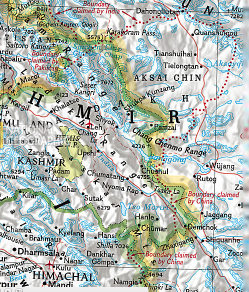
In the western sector, where the dispute flared up in the past summer, the LAC is essentially the ceasefire line created by the war of 1962. In the eastern sector, while Chinese forces occupied the territory they claimed till the plains of Assam, after the ceasefire they withdrew to positions north of the McMahon Line that they had held before the war. In eastern Ladakh, however, they expanded their positions even beyond their own claim line of 1960.
Since 1993, both sides have broadly agreed on where the LAC runs, but there are some 16 areas where there is an overlap, in a range of 0.5-15 km, over where their respective boundary lines run. Both sides have created standard operating procedures through which they patrolled up to their version of the LAC, even while ensuring that the process did not lead to any clashes.[1]
Today, for reasons explored in this paper, both the tracks have come to a dead-end. There has been little movement on the effort to strike a political bargain to settle their dispute since the mid-2000s, despite their negotiators having worked out the technical parameters of a settlement. Equally, in recent years, measures to stabilise the LAC and manage the points of dispute have also come under pressure. In the spring of 2020, this process broke down in eastern Ladakh when Indian and Chinese forces clashed in the Galwan and Pangong Tso areas. The confrontation resulted in injuries and deaths of border personnel on the LAC, for the first time since 1975. Both sides have mobilised larger forces in the area in what constitutes the most serious stand-off since the Wangdung/ Sumdorong Chu crisis in 1986-87.[2]
Despite obfuscation by the government and claims to the contrary, it is clear that China has currently established itself several areas across the LAC in eastern Ladakh and has occupied an estimated 600 sq km of territory on which India also has a claim.[3]This paper examines the manner in which the two sides have sought to handle the border issue and concludes that the two countries have been working at cross-purposes. While India has sought to address the border dispute with its protracted negotiations and confidence-building measures aimed at an eventual settlement, China has handled the dispute in varied ways—from seeking to resolve it in its own favour till the early 1980s and, since then, using it to manipulate its larger relationship with India.
The LAC Problem
Former Foreign Secretary Shyam Saran once noted, assessing the history of India-China border disputes, that the Chinese claim to Aksai Chin has not been particularly strong and that the Qing Empire even at its zenith never claimed territory south of the Kun Lun range.[4]Saran observed that the exercise of sovereignty in the area by the Kashmir state “is well documented.” Further, the Ladakh-Tibet boundary was well established and accepted by the Qing. “It was in the 1962 operations that Chinese forces created an alignment further west, which is, broadly, the current LAC.”[5]
For his part, former National Security Adviser (NSA) Shivshankar Menon has said that the notion of an LAC served China well from the 1950s until the late 1980s, in providing a shifting open-ended concept of the status quo that China could use to prevent the border “from becoming militarily live except where China wished it to be.”[6]It now appears that China followed the same strategy in eastern Ladakh in the summer of 2020. China is exploiting the ambiguity on where its version of the LAC lies, for purposes that are not quite clear but could well have little to do with the border itself.
As earlier noted, there were several places along the LAC[b]where the two sides had overlapping claims. While face-offs have not been uncommon, they have been managed in the last two decades through mutually worked out protocols. In May, however, China transgressed into two new areas in the Galwan river valley and around Gogra and Hotsprings. Of these, the one in Galwan on 15 June 2020 was more serious and led to an incident where 20 Indian army personnel died and another 80 were injured; 10 personnel were held prisoner for a brief period.
China immediately blamed the Indian Army for the incident. Speaking at a routine press briefing in Beijing on 19 June, the Foreign Ministry spokesperson Zhao Lijian outlined the Chinese perspective of the 15 June incident on the LAC in the Galwan Valley. “The Galwan Valley is located on the Chinese side of the Line of Actual Control in the China-India boundary,” he insisted.[7]According to his account, Chinese troops had long patrolled the area, but since April 2020, Indian troops had “unilaterally and continually built roads and other facilities at the LAC in the Galwan Valley.” He blamed these “Indian actions” for the 15 June incident.[8]
To be sure, there is no formal version of the LAC—unlike the LOC which has been surveyed and delineated on maps counter-signed by Indian and Pakistani officials. However, enough has happened in the past decades to ensure that both China and India have a clear notion of where the LAC lies and the points of differing perceptions of where it runs. Indeed, such awareness underlined the Indian official spokesperson’s statement on the day following the clash, as he noted that “the position with regard to the Galwan Valley has been historically clear.”[9]He pointedly added that “Indian troops are fully familiar with the alignment of the LAC in all sectors of the India-China border areas, including in the Galwan Valley.”[10]His statements were not mere rhetoric, but based on the fact that the Indian side has the Chinese map of the central sector, and has in 2002, seen the map of their understanding of the western sector. Indian patrolling points in this area were set in the late 1970s and the Indian military has a two-decade-old understanding of China’s patrolling patterns and are therefore aware that China had gone beyond its own conception of the LAC.
This becomes evident viewing the tortuous history of the efforts to settle the border dispute and, pending such a resolution, to clarify just where the LAC runs in an inhospitable and largely uninhabited mountain area, as a means of ensuring that it remains peaceful.
LAC: A short history
There are those who are of the view, like former NSA Menon, that China has been using the term ‘Line of Actual Control’ to shape the border discourse in their own favour.[11]This was the case, for instance, in their occupation of Aksai Chin in the western sector; and in the east, China declared that the LAC largely followed the “illegal McMahon Line” which was delineated on a map and generally followed the Himalayan watershed. Similar conditions were absent in the west. Neither India nor China exercised “any settled jurisdiction or regular administration” in the Aksai Chin area. There was a vacuum which China filled because it used the old trading track that passed through from Xinjiang, through Aksai Chin, to occupy Tibet. And thereafter it built a case to justify the occupation.
On 23 January 1959, Premier Zhou Enlai for the first time informed Prime Minister Jawaharlal Nehru “that the Sino-Indian boundary has never been formally delimitated.”[12]As a consequence, Zhou wrote, “there are certain differences” over the border. He proposed that the two sides maintain the status quo— “each side keep for the time being to the border areas at present under its jurisdiction and not go beyond them.”[13]In another letter in November 1959, Zhou proposed that both sides withdraw 20 km from “the so called McMahon Line” in the east and “from the line up to which each side exercises actual control in the west.”[14]At the end of the same year, on 17 December, Zhou told Nehru that “the line up to which each side exercises actual control in this sector is very clear, just as it is in the other sectors of the Sino-Indian border.” He said this conformed to a map that had been published in China in 1956.[15]
This author has accessed some of the relevant historical maps where China shows Aksai Chin as being within their border, but both the Chip Chap and the Galwan river Valleys are on the Indian side of the LAC. These maps also showed that the border line intersected Pangong Tso at its narrowest point near the ruins of Khurnak Fort, which was occupied by Chinese forces in June 1958. They have since moved farther West to Siri Jap which they captured in 1962.
Map 1. Detail from a 1950 map published in Shanghai
Source:US Library of Congress.The distinct Pangong Tso at the bottom right provides a reference point to the region.
Map 2. A map published in Shanghai in 1956
Source:http://hdl.loc.gov/loc.gmd/g7820.ct004232. This map isbased on older Kuomintang-era maps, shows all of Shyok basin, which includes the Galwan river, as Indian territory. Again the reference can be provided by Pangong Tso on the lower right hand side.
The 1956 line shown on these maps was, presumably, broadly the one affirmed by Zhou in his letter to Nehru in December 1959. Yet, the very next year, following the breakdown of the Zhou-Nehru talks in New Delhi, China came up with another version of the line. That year, as part of the process of examining the respective claims of both sides, Chinese officials provided their Indian counterparts the latitude and longitude of the points that constituted the border line of their territory.
According to the officials, from Karakoram Pass, the boundary ran eastward to a point east of 78° 05’E, and the line turned southwest to a point 78° 1’ E and 35° 21 ’N where it crossed the Chip Chap river. After this, it turned southeast along the mountain ridge and passed through two peaks 6845 metres (78°12’ ‘E and 34° 57’N) and Peak 6598 metres (78° 13’ E 34° 54’N).*(misprinted in report as 68°) Thereafter it crossed the Galwan River at 78°13’E, 34° 46N. Thereafter it passes through peak 6,556 (approximately 78° 26′ E, 34° 32′ N), and runs along the watershed between the Kugrang Tsangpo River and its tributary the Changlung River to approximately 78° 53′ E, 34° 22′ N. where it crosses the Changlung River and reaches the Kongka Pass. It reached the Pangong Lake at 78° 49’E, 33° 44’N and crossed the southern bank of the Lake at 78° 43’E, 33° 40’ N.[16]
Today, when plotted on Google Earth, this is where the coordinates lie:
Map 3. The LAC, plotted using the points of latitude and longitude provided by China in 1960
Source:Plotted by author on GooglePro imagery. What it reveals is that in Pangong Tso, the Galwan river Valley and in the Chip Chap river/Depsang Plains, China is making claims beyond its 1960 definition of the border.
In the 1962 war, in the Western Sector, China declared a unilateral ceasefire and withdrew their forces from the territories they had captured. However, in the western side they only went back 20 km. Since Indian posts in the China-claimed areas had been wiped out, and others withdrawn, there was no way of verifying just what this meant. Officially, the Indian position has been that the LAC should be the line that divided the two forces on the eve of the war, on 8 September 1962.
By default, the LAC which India has had to accept was the one that China had created through war since Indian forces did not return to the area for several years. China has largely maintained their 1960 claim line which, in any case was different from their supposedly definitive line of 1956, reiterated in 1959. But as former foreign secretary Saran has pointed out, China also retained 3,000 sq km of additional territory they had occupied in the Chip Chap Valley, Pangong and Spanggur areas.[17]
In places like Pangong Tso and Depsang, China did not ease its westward pressure in the ensuing decades. And today, China aims to alter the LAC in the Galwan area as well.
Figures 1a and 1b. China’s Claim in Galwan, 1960 vs. 2020
Source:Author’s annotation of a Google Pro imagery
Figure 1b.
Source: Author’s annotation of a Google Pro imagery. China has advanced roughly 0.5 km from the coordinates they had given in 1960, to the bend in the river where the clash took place on 15 June 2020, and which is clearly on the Indian side of the LAC. In addition, China is claiming additional territory till the estuary on the middle left, some 7 km downriver.
Figures 1a and 1b depict the difference between the point based on the coordinates of the Official Report of 1960, and the current Chinese claim. Indeed, while the incident took place at the bend of the river which is on the Indian side of the LAC, and is less than 0.5 km from the 1960 point, China is also claiming the entire Valley till the confluence of the Shyok and the Galwan, which is another 7 km or so from the bend. The Chinese military spokesperson insisted that India had “trespassed into China’s territory” despite their commitment to “not cross the estuary of the Galwan river” made during the first meeting of the two Corps Commanders on 6 June 2020.[18]
Figure 2 also brings out the discrepancy between China’s current claim and their 1960 one in Pangong Tso.
Figure 2. Rival claims on Pangong Tso
Source:Author’s annotation of a Google Pro imagery. China has advanced to Finger 4, through which their claim line runs, whereas their own border, as per the 1960 coordinates lies at least 8 km eastwards.
To be sure, this must also take into account that after the 1962 war, the Chinese troops in the eastern sector went back to their positions north of the McMahon Line that had marked the border. But in the west, as indicated above, they retained additional territory.
Following the Sumdorong Chu face-off, it had become clear that China was not able to control events on the border, as it had been used to in the past.[c] This was the reason why they agreed to sign the Border Peace and Tranquility Agreement (BPTA) during then Indian Prime Minister P.V. Narasimha Rao’s visit to Beijing in 1993, and also committed themselves to a policy of clarifying the LAC wherever it was needed. It was evident, however, that China was not happy and in the talks preceding the agreement, its officials argued that maintenance of peace and tranquility on the LAC “should not automatically imply agreement between India and China as to thealignmentof the LAC” (emphasis added).[19]
India has not been comfortable in accepting a ceasefire line as the LAC, as its view of where the current border runs arises from the BPTA of 1993, the “mother agreement” from which many others have emerged since. The key clause of the agreement related to working out a common alignment of the Line of Actual Control, for the obvious reason that, absent an agreed line, it would be more difficult to maintain peace and tranquility in the region.
India was initially hesitant to accept the concept of the LAC, and made it clear that the LAC that India accepted was not some notional line of the 1950s or 1960s, but the one that was based on the ground realities of 1993, and not on territorial claims. This implied that India accepted that there would be some places where the claims overlapped, and which needed clarification. To aid this process, an expert group of military and diplomatic officials was created. In essence, the BPTA and its successor agreements committed both countries to maintain status quo on the border even while they resumed normal intercourse and continued to strive for a final settlement of the dispute.
Stability and instability along the LAC
In 1988 then Prime Minister Rajiv Gandhi visited China, following which border talks were undertaken by a Joint Working Group (JWG) comprising of the respective foreign secretaries and their delegations. After the BPTA, an expert group was set up under the JWG with the responsibility of dealing with the places on the LAC where the two sides had differing views.[20]Three years after the BPTA, in November 1996, the two countries signed an equally significant agreement on Confidence Building Measures in the Military Field. This sought to not just maintain status quo along the LAC, but to actually cause the purposeful thinning of forces and deployments through negotiations. Again, this was contingent on working out a mutually accepted LAC.[21]
Between 1989 and 2005, the JWG held some 15 meetings, but it failed to resolve the differences between the two sides on the areas of the LAC where they had differences. The JWG only managed to go as far as exchanging maps of the middle sector and showing maps of the other sectors to each other. When it came to the western sector, in June 2002, the differences proved to be too great. But China actually balked because they reckoned that a recognised LAC would freeze the status quo—something that would be to their disadvantage.[22]
On 11 April 2005, the two sides signed the breakthrough ‘Agreement on Political Parameters and Guiding Principles for the Settlement of the India China Boundary Question’. The agreement will be discussed in detail in a latter section of this paper. Key in this agreement was that Article IX reiterated the need for the JWG and the expert group to continue their work, including that relating to “the clarification of the line of actual control.”[23]
On the same day, the two sides also signed a protocol to deepen the CBM regime on the border. These ‘Modalities for the Implementation of Confidence Building Measures in the Military Field along the Sino-Indian border’ set up the Standard Operating Procedures for the military in the event that a Chinese patrol met an Indian one in a contested area, or vice versa: They would display a banner on which it was emblazoned, “This is Indian/Chinese territory”. They would then unfurl a second banner with the words, “Turn around and go back to your side.” Such incidents where these banners were shown, came to be known as “face-offs”.[24]Over the years, both India and China increased their presence up to what they considered their version of the LAC. China did this before India, because they have a huge terrain, vast resources, and the climatic advantage; India has had to play catch up since.[25]
A watershed occurred in 2008. China rode out the global financial crisis of 2008 reasonably well, its economic trajectory was affected to a lesser degree than other developed countries. That was also the year of the Beijing Olympics, and more important, from India’s point of view, the Tibetan revolt. This is something that rattled Beijing since it was under the impression that it had the situation in Tibet well under control. Beginning from Lhasa, the unrest spread to Tibetan-inhabited areas outside the Tibet Autonomous Region. China was convinced that the riots had been orchestrated by the Dalai Lama and the Tibetans in India.[26]
This period coincided with India’s decision to enhance its border infrastructure, in accordance with recommendations from the China Study Group (CSG)[d]to set up targets for completing 73 China-India border roads and enhancing Indian capabilities across-the-board along the LAC. The decision was taken to build tunnels to connect the highways, as well as a trans-Arunachal highway. In addition, the UPA government sanctioned the creation of two new mountain army divisions and additional armoured units along the LAC. Four advanced landing grounds were activated in Chushul, Fukche, Demchok, and Daulat Beg Oldi, and top-of-the-line fighters like the SU 30MKI were stationed in Tezpur, Chabua and Bareilly. Importantly, these decisions were backed by a steadily growing Indian economy.[27]
This period saw not only the improvement of roads, but also the use of the ITBP/Army in place of Subsidiary Intelligence Bureau (SIB) parties to patrol the border. The basic patrolling limits were drawn up in 1976 when the China Study Group was first set up, and revised over time, especially after the 1993 BPTA and 1996 agreements. The frequency and size of the patrols and their performance was improved, but India was clear on where, in its view the LAC lay, something that had been determined in 1976 through careful survey using satellite imagery and cleared by the CSG.[28]
Owing to increased capabilities on each side, more frequent complaints of incursion emerged. In January 2012, the two sides created a Working Mechanism on Consultation and Coordination for India-China border affairs, led by Joint Secretary-level officers of their respective foreign ministries. This was more, as its name suggested, for coordination and consultation, and was specifically enjoined not to discuss the boundary question or the work of the Special Representatives (SRs).
What soon became apparent as well is that the PLA has a major role in running China’s border policy. In January 2013 China had given India a new draft Border Defence Cooperation Agreement (BDCA) which called for a freeze on the military situation on the border. This was not acceptable to India and China’s draft was revised to reflect this when the agreement was finally signed in October 2013 following the resolution of the Depsang issue in May 2013. An interesting aspect of the agreement was that it brought the PLA directly into border management since the Chinese signatory to the agreement was Admiral Sun Jianguo, the Deputy Chief of Staff of the PLA. The Indian signatory was the Defence Secretary.[29]
The CBMs and SOPs worked well, but an episode in the Depsang region, in the northern-most part of the LAC, set off warning bells. Between 1993 and 2013, the two sides had maintained a roughly similar routine on the border: both patrolled to the extent of what they saw as the LAC and both maintained the SOPs relating to contact that were worked out in 2005.
The pattern seemed to change when on 15 April 2013, the PLA established an isolated camp of five tents 19 km inside what India considers the LAC in the Depsang Plains. It was unexpected and set off a train of events that compelled India to re-examine the issue of the border and its role in the bilateral relationship. The end of a three-week standoff was as sudden as was its beginning.[30]A crucial reason why India could terminate the Depsang incident successfully was that New Delhi threatened to call off Li Keqiang’s visit scheduled for 18 May of that year.[31]There was yet another alarm the following year, as the PLA chose to stage their demonstration during Xi Jinping’s visit to New Delhi in September in the Chumur sector. They began building a road to an area near where India had an observation point. The Indian side mobilised a substantial force to block them and the standoff continued for two weeks. Eventually the two sides pulled back and agreed on a moratorium in patrolling the area; it worked for some time.[32]
A qualitative shift has happened in 2020, as China seems to be asserting a new set of claims. They have come in 15 km or so into the Indian side of the LAC and have blocked Indian patrols to the limit of India’s claim in the Depsang area. They have camped in the Finger 4 area of Pangong Tso, preventing Indian patrols to go to Finger 8 area, as per the 1960 definition of the LAC. In Galwan, they have come up with an entirely new claim which says that the LAC runs along the estuary of the Galwan river, or the confluence of the Galwan and the Shyok rivers. In other words, China is signaling that it once again wants to revise its claim, at India’s cost.
Settling the Border
Even as the process of maintaining peace and tranquility along the LAC has been seriously compromised, there seems to be little happening in the efforts of the two sides to arrive at a final settlement of their border through a process they had initiated in 2003. In the run-up to the war of 1962, the two sides had attempted to resolve their border dispute through negotiations. Through correspondence and direct talks, both provided their own proof that the areas they claimed belonged to them. This was even as China consolidated itself in the Aksai Chin region and created facts on ground that India sought belatedly to remove through its “forward policy” in 1961. Negotiations at the highest levels crashed when Zhou Enlai arrived in New Delhi in April 1960 to negotiate and was willing, according to some accounts, to swap China’s eastern claim with India’s western one. However, he met an adamant Nehru who refused to negotiate on any point.[33]
Subsequently, the two sides entered into official talks. Both sides presented detailed evidence of their respective claims in the talks that were held in Beijing, Rangoon and New Delhi between June and December 1960. Each session of these talks would often go on over a month and here, India presented 650 items of evidence against 245 from China. Beijing had no map on a scale greater than 1: 5 million, which would be the size of a schoolroom chart. Map 4 is equivalent to the kind of maps that Chinese officials would have presented. Such maps could hardly provide a detailed picture of their claims.[34]
The voluminous report prepared by the officials was released in early 1961 but it made little difference to the negotiations since the officials had no authority to make recommendations.
Map 4.
Source:https://images.natgeomaps.com/PROD_ZOOM/RE00620546.html. This is from a standard National Geographic map which shows how poorly the Chinese presented their case in 1960. This map is of the scale 1: 5.45 million, while the most detailed map provided by Chinese officials in 1960 was of 1: 5 million scale.
After the war of 1962, the threads of negotiations were only picked up in 1981 when India and China had conducted eight rounds of vice-minister level talks between 1981 and 1987. These talks failed, with China first proposing a revival of their swap proposal—accepting the Indian eastern claim for their western one—and then doing a 180-degree-turn and declaring that the eastern problem was bigger than the western one.[35]
The Sumdorong Chu crisis of 1986-87, when both sides mobilised their forces along the LAC, pushed their effort in another direction. In 1988, after a breakthrough visit by Rajiv Gandhi to Beijing (the return visit for Zhou Enlai’s 1960 visit), the two sides sought to normalise their relations despite the border dispute. It was in the official talks in Beijing that the two sides abandoned efforts to work out a negotiated border settlement and instead seek to stabilise the Line of Actual Control that had divided their forces since the ill-fated war.[36]The talks led to the signing of the BPTA and the other agreements discussed earlier in this paper.
Striking a political bargain
In 1998, Prime Minister Atal Bihari Vajpayee took India across the nuclear threshold with the Pokhran-II nuclear tests.[e]He also initiated diplomacy with both Pakistan and China to resolve outstanding disputes. Following his visit to Beijing in 2003, India and China agreed to negotiate a solution to the border issue which would set aside the legal route relying on maps and treaties and, instead, be based on a political bargain. They appointed Special Representatives (SRs) who would lead the process. As a measure of the importance attached to the process, the PM appointed his principal secretary and national security adviser, Brajesh Mishra, as the Indian SR. The Chinese side appointed Dai Bingguo, a senior politician and diplomat whose effective job was as Mishra’s counterpart to President Hu Jintao.[37]
The talks between the two sides made quick progress and by April 2005, they completed the first stage of the three-stage settlement process when the two countries signed an ‘Agreement on Political Parameters and Guiding Principles for the Settlement of the India China Boundary Question’.[38]This was despite the change of governments in India and the appointment of J N (Mani) Dixit as both NSA and SR; he would be succeeded in January 2005 by M K Narayanan. This Stage I agreement spelt out the contours of a possible border settlement on the basis of a mutual exchange of claims. Article IV of the agreement noted that “the two sides will give due consideration to each other’s strategic and reasonable interests, and the principle of mutual and equal security.” While Article VII observed, “In reaching a boundary settlement, the two sides shall safeguard due interests of their settled populations in the border areas.”[39]It is difficult to make any other construction of these clauses except to note that they sought to legalise the swap that had been talked about since 1960— China had important “strategic and reasonable interests” with Aksai Chin, while India needed “to safeguard settled populations” in Arunachal Pradesh.
Things, however, were more than what they seemed. In June 2007, at the sidelines of a meeting in Berlin with Indian External Affairs Minister Pranab Mukherjee, Chinese Foreign Minister Yang Jiechi told Mukherjee that the “mere presence” of populated areas would not affect China’s claims on the Sino-Indian border. In other words, China would not walk away from its eastern claims.[40]This, in essence undermined the achievement of the 2005 agreement and meant that China was once again walking back from a possible swap of claims.
Global developments like the 2007-2008 financial crisis and bilateral deals such as the Indo-US nuclear agreement of 2008 put a great deal of pressure on the CBMs and agreements between India and China. So, too, did Indian efforts to enhance their infrastructure and deployments along the LAC. Meanwhile, it soon became clear that even the SR process had effectively run out of steam: at the 13thround of SR talks in 2009, the remit of the representatives was expanded from working out a border settlement, to dealing with the whole gamut of Sino-Indian relations.[41]
In 2012, at the 15thround, the last in which Di Bingguo would participate, the two SRs negotiated a document listing the work done and what remained. It also outlined the “common agreement” the two sides had achieved in the 15 rounds of their talks. According to a commentary in an Indian newspaper in May 2013 by China’s former Ambassador to New Delhi, shortly after the termination of the Depsang incident, the two sides arrived at an 18-point consensus document that outlined their areas of agreement.[42]
Fourteen years since the 7thround of talks in February 2006, the two sides are today still working to arrive at the Stage II agreement. This would involve a framework of technical agreements that would translate into the final ‘border package’. Stage III would be the actual delineation and demarcation of the boundary on the map by civil, military and survey officials.
Some hints of the kind of technical consensus that the two sides had arrived at became apparent during the Doklam crisis.[f]In a press release issued following the incident, the Ministry of External Affairs said that in 2012, the two sides had agreed “that the tri-junction boundary points between India, China and third countries will be finalized in consultation with the concerned countries.” In other words, all three countries would be involved in arriving at a decision.[43] Further, that all that the 1890 Convention had done was to provide India and China a “basis of the alignment” for the Sikkim-Tibet border, not the alignment itself. This was not spelt out, but presumably it was the watershed.[44]
In a 2015 interview, Shivshankar Menon noted: “We have got it to the point where it (a settlement) can be done by an act of political will on both sides.”[45] He said that in the multiple rounds of SR talks, India has done the required technical work, and it had become a matter “of a political decision.”[46]His colleague, Shyam Saran, had then explained why such a scenario was not forthcoming. For any settlement to be politically acceptable in India, it must be ‘LAC plus’—meaning that India retains what it has in the east, and China concedes some territory to India in the west. India has signaled that this is the additional territory that China occupied in the west, beyond its own 1959 claim. On the other hand, pointing to China’s current insistence in demanding Tawang, Saran says that a settlement has a wider context, which includes the Tibet issue and therefore “the current situation will continue fairly indefinitely.”[47]
Under the Modi Government
In the early years of the Modi government, there was a great deal of optimism that India could come to a resolution of its border dispute with China. There was, of course the SR achievement of working out the technical parameters of a possible settlement. More importantly, both India and China now had strong leaders who could presumably manage the fallout of a settlement which would not deliver either country its maximum claim.
Statements by Chinese leaders, ranging from Xi Jinping to Foreign Minister Wang Yi, expressed willingness to move to a “final settlement”.[48]Despite the fallout of the confrontation in Chumar, the two sides agreed to insert the following paragraph in the Joint Statement following Xi Jinping’s 17-19 September 2014 visit to New Delhi: “Recalling the Agreement on the Political Parameters and Guiding Principles for the Settlement of the Boundary Question signed in April 2005, both sides reiterated their commitment to an early settlement of the boundary question and expressed their conviction that this will advance basic interests of the two countries and shall, therefore, be pursued as a strategic objective.”[49]In turn, when External Affairs Minister Sushma Swaraj visited Beijing in February 2015, she explicitly declared that “my government is committed to exploring an early settlement (of the border issue).”[50]She also noted that the two countries “have strong leaders. They are also keen on an out-of-the-box solution.”[51]
Prime Minister Modi, however, took another tack in his interaction with Xi Jinping in Ahmedabad in 2014, following the Chumar crisis. Modi pressed the Chinese leadership on the importance of clarifying the LAC. He brought up the issue three times at his private dinner with Xi in Ahmedabad on 17 September, and again during the one-on-one talks the next day in New Delhi. In the press briefing after the talks, Modi said: “I raised our serious concern over repeated incidents along the borders.”[52]The prime minister also said that he suggested that “clarification of Line of Actual Control would greatly contribute to our efforts to maintain peace and tranquility,” and that he had requested Xi “to resume the process of clarifying the LAC.”[53]
That Modi was serious about the issue of clarifying the LAC became evident on 14 May 2015 during the first leg of his first visit to China as prime minister. In his meeting with Xi, he told him that it was one thing to talk of the ‘Asian century’ of India and China, and another to achieve it given the roadblocks between the two countries, primarily over the LAC. He reminded Xi that this was the issue that had cast a shadow over his visit to India the year before.[54]In his public remarks at the Tsinghua University during the same visit, he repeated the point, noting that because of the lack of clarification, “a shadow of uncertainty always hangs over the sensitive areas of the border region.” The Chinese leadership ignored the suggestions. Later, a middle-level foreign ministry official, Huang Xilian, briefed journalists about Beijing’s refusal to countenance that process. Without specifying, he claimed that the clarification process had made the border issue more complex. China let it be known that they wanted a Code of Conduct that would freeze border construction.[55]
It is therefore not surprising that despite the fact that the Wuhan informal summit of April 2018 arose out of the contretemps relating to Doklam, the two leaders hardly addressed the border issue, to go by the official press release. They were content to issue “a strategic guidance to their respective militaries” to communicate better and more frequently with each other and strengthen the CBM regime relating to peace and tranquility. They commended the work of the two SRs “to seek a fair, reasonable and mutually acceptable settlement to the border question.”[56]Nothing more was said publicly.
The Chennai Informal Summit of 2019 was even less communicative. The press release devoted only a paragraph to the subject, where it spoke of the need to continue efforts to maintain peace and tranquility and work on additional CBMs. As in the first informal summit in Wuhan in 2018, the two leaders commended the work of the SRs to “arrive at a mutually agreed framework for a fair, reasonable and mutually acceptable settlement.”[57]This has been a standard formulation that says little.
To be sure, the SR process continues. The last round of formal talks, the 22nd, took place in December 2019 in New Delhi. While little happened with regard to a border settlement, if at all, the SRs have been a critical instrument in firefighting. After all, it was through the SR mechanism that the two sides were able to overcome the Doklam crisis and set the stage for the informal summit process. Likewise, it has proved to be invaluable in drawing down the tensions that have currently arisen between the two countries. Clearly, till the end of 2019, some four months before the current series of events unfolded on the border, strategic communications between the two countries—which was the original aim of the informal summits—was not happening. There was little anticipation, at least in New Delhi at the turn events would take. This could be a result of deliberate deception on the part of China, or some COVID-19 pandemic opportunism on the part of the PLA. Perhaps it is not fair to put all the blame on the SRs or the diplomats who have been engaged in negotiations over the years.
The events of 2020 so far have shown that although India’s borders with China have been largely peaceful in the last 60 years or so, they perpetually have the potential of becoming unstable. Layers of confidence-building measures and operating protocols can be created to manage the borders, but it could take the mal-intent of one of the two parties to undermine these mechanisms. This was made apparent in the crisis that has occurred in eastern Ladakh. There, a process of disengagement and de-escalation is underway through talks at the Corps Commander-level at a point near the Pangong Lake. The SRs from the two sides are in the picture, as are officials of the Working Mechanism for Consultation and Coordination on China-India Border Affairs.
On 30 July, however, a speech at a webinar organised by the Institute for Chinese Studies by the Chinese ambassador Sun Weidong has ignited controversy. Sun suggested that the whole problem has been created by Indian troops “illegally crossing the LAC to the Chinese side.”[58]Such remarks indicate that China truly does not accept the Indian notion of the LAC, but its own, which is flexible and open to opportunistic change.
Simply declaring that “China’s traditional customary boundary is in accordance with the LAC” in the north bank of the Pangong Tso, as Ambassador Sun does, is not enough to make it so.[59]After all, there is a Chinese declaration of 1960 that gives lie to such a claim, as well as Indian and Chinese patrolling patterns there for the last half-century. Although the extent of Chinese incursions in Pangong, Gogra, Galwan and Depsang may have been anywhere between 1-15 km, and in itself not earth-shaking, they are a serious change that demand some explanation, and indeed, corrective action, rather than a bland counter-assertion and denial.
Today the Sino-Indian relationship, carefully nurtured since the late 1980s, is broken. Agreements—from 1993, 1996, 2005, 2013— have become redundant, because the underlying sense of purpose that persuaded India and China to take them up has frayed. As for the final settlement of the dispute, that remains in a limbo for the same reason that the LAC is still unclarified.
There are perhaps a mix of issues at work here. The recent tensions, beginning in 2013 in Depsang, have been in eastern Ladakh. Doklam is an exception because it is in Bhutanese territory. China, however, which has been vehement about its eastern claims, in particular, to Tawang, since the mid-1980s, does not seem to be too active there at present. The qualitative change in the activity in eastern Ladakh this year could have multiple causes—the general nervousness with regard to domestic opinion in the face of the COVID-19 pandemic, and a sense of insecurity arising from the Indian infrastructure projects and its growing military capacity. An additional factor could have been the reassertion of the Indian claim over Aksai Chin by the Union Home Minister Amit Shah in the wake of the derogation of Article 370 in August 2019.[60]
American political scientist, M Taylor Fravel has argued that China has usually viewed the border with India as a “secondary strategic direction”.[61]This required “to be managed so that it does not impact on China’s ability to pursue its interests in other areas that the country deems more important.” For China, the primary security challenge comes from the US-led alliance system in the western Pacific that washes upon the heartland of China. This is an area of continuing and, indeed, growing tension as Chinese capabilities confront US presence.
India has sought to exploit this stand-off by its participation in the Quad and its ties with Vietnam and Japan. Yet, this Indian side-show has been fitful and lacking in credibility at present. The Sino-Indian encounter, thus, remains across their land border. In such circumstances, Fravel notes, “When China believes India threatens its claims in the dispute or stability along the border, China has responded in order to restore stability and not to impose a final settlement.”[62]
Conclusion
The real drivers of the developments in the Sino-Indian border dispute are issues larger than just those relating to the border itself. This has been reflected in the manner China has dealt with issues relating to its sovereignty—Taiwan, Hong Kong, the South China Sea and, in a sense, eastern Ladakh. Here, without doubt, the course of the COVID-19 pandemic has played a role, one which saw China being hit first and recovering its equipoise, while the US has been left reeling, in considerable measure due to its poor handling of the crisis.[63]
American analysts have been arguing in recent months that a fundamental change has occurred in Chinese policy. Writing in July, Kurt Campbell and Mira Rapp-Hooper argued that what the world was witnessing was changed Chinese behaviour. Where in the past, China sought to maintain a stable political environment, pulling back if they overreached, this time around, “the world may be getting a first sense of what a truly assertive Chinese foreign policy like.”[64]This view is echoed by Richard Haass who believes that it is neither COVID-19, nor any domestic issue in China that is driving its assertiveness. The recent events, he wrote, are “representative of a new era of Chinese foreign policy, one that reflects the country’s growing strength and ambitions.”[65]
Indeed, if the wellsprings of Chinese policy have changed, India too, must change and recalibrate its own. New Delhi should not provide comfort to Beijing’s strategy of stabilising and destabilising the border at will—something which they have been doing since the 1950s. It is time for New Delhi to take a new tack in its China policy. One aspect of it is the general decoupling that is emerging in the economic relations between India and China.
On the border issue, too, India needs to press China to settle it along the framework that has been emerging in the Special Representatives talks. This may prove, however, to be a difficult process, as it will involve political costs to be paid by New Delhi as well. The alternative is to insist that Beijing uphold, with urgency, its commitments to the BPTA and two successor agreements that call for the clarification of the LAC. Chinese excuses to resile from their commitments here are specious, as is clear from Ambassador Sun’s vehement rejection of the proposal. He has disingenuously argued that “if one side unilaterally delimits the LAC as per its own understanding during the negotiations, that could create new disputes.”[66] It is not clear what he is referring to, since the original exercise was not meant to be unilateral, but implemented by officials of both sides.
China clearly intends to continue to use the LAC to manipulate their India policy. India ought to be equally vehement in preventing China from doing the same. Prime Minister Modi’s approach here has been prescient—he had warned in 2014 and 2015 that an unclarified LAC could have consequences. Now, perhaps, he should take up the issue at his level once again.
Indian officials have laid out the parameters of the emerging situation. Chief of Defence Staff Bipin Rawat has said India may have to take recourse to military measures to set the situation right.[67]On the other hand, External Affairs Minister S Jaishankar has made it clear that the military and diplomatic channels work in tandem. And that any solution “must be predicated on honouring all agreements and understandings. And not attempting to alter the status quo unilaterally.”[68]
India knows that given the asymmetry with China, it is simply not possible to deal with it through its own resources. New Delhi will have to add heft to its position through diplomacy in the Indo-Pacific region and elsewhere to ensure that Beijing begins to address Indian concerns seriously. The Sino-Indian border is unlikely to assume the status of Fravel’s primary strategic direction. But India can, and should, sharply escalate its military capacity, generally, as well as along the LAC, and adopt a posture that will enhance the importance of the “south-west direction” in Chinese calculations. India already occupies strong defensive positions along the LAC, but Indian military capabilities are defensive and erratic: good in certain places, but mediocre and poor in most. Some capabilities are already causing China worry in parts of the LAC, but boosting them to pose a significant challenge to China beyond Tibet is a different level of enterprise, given India’s current economic predicament. Yet that may be the only route available to persuade Beijing of the importance of stability that it could obtain by settling its border with India.
Endnotes
[a]Incursions across the undemarcated Line of Actual Control that marks the border between India and China have not been uncommon in this area. They have, till now, been dealt with through standard protocols to prevent any violence. But on 15 June 2020, Chinese and Indian soldiers got involved in a violent clash that led to the deaths of 20 Indian Army personnel and injuries to over 80. There were unspecified Chinese casualties as well.
[b]The very length of the LAC is also contested, with the Indian version being 4056 km and 3488 km, and the Chinese claiming it is a shorter 2,000 km long.
[c]The Sumdorong Chu is a rivulet adjacent to the Thagla ridge, north of Tawang which was the site of the battle that took place at the outset of the 1962 Sino-Indian war. The Wangdung pasturage on the river is claimed by both India and China. Tensions relating to its occupation by China in 1986 led to a military mobilisation all along the LAC. The situation was defused through talks in May 1987, but mutual withdrawal from forward posts in the area was only done in 1995.
[d]In 1976, the Cabinet Committee on Political Affairs established the China Study Group under the Foreign Secretary to supervise the management of the border. Currently it is chaired by the National Security Adviser and has amongst its members, the Foreign Secretary, Home Secretary, Defence Secretary, the three Vice-Chief of the Services, Director Intelligence Bureau and the Secretary (R).
[e]These were a set of five nuclear weapons tests conducted by India in May of 1998. This was the second round of testing, the first being the sole test of 1974 called Pokhran I.
[f]The standoff near the India-China-Bhutan trijunction in 2017 arose from an Indian military blockade in the Doklam plateau in what it recognises as Bhutanese territory, to prevent Chinese forces from building a road to the Jampheri ridge which would give them an overview of India’s sensitive Siliguri Corridor.
[1] Shivshankar Menon, Choices: Inside the making of India’s foreign policy, (New Delhi: Penguin/Allen Lane, 2016), p. 31
[2]Activity in the Galwan Valley can be seen in Simon Scarr and Sanjeev Miglani, “Satellite images suggest Chinse activity at India’s Himalayan border before clash”, Reuters,June 19, 2020.
[3]Mandeep Singh Bajwa, “Military Digest: Eastern Ladakh Sitrep: The “bottleneck in Indo-China talks,”Indian Express (Chandigarh),August 2, 2020.
[4]Shyam Saran, How India sees the world: Kautilya to the 21stcentury,” (New Delhi: Juggernaut, 2017) pp135-6
[5]Saran, How India sees the world
[6]Menon Choices, p. 41.
[7]“Foreign Ministry spokesperson Zhao Lijian’s regular press conference on June 19, 2020,” Ministry of Foreign Affairs People’s Republic of China.
[8]Chinese Foreign Ministry Spokesperson June 19, 2020
[9]“Official spokesperson’s response to media queries seeking comments on the statement issued on 19thJune by the Chinese spokesperson on the events in the Galwan Valley areas,” Ministry of External Affairs, Government of India, June 20, 2020,
[10]Indian Official spokesperson June 20, 2020
[11]Menon, Choices p. 40-41.
[12]“Letter from the Prime Minister of China to the Prime Minister of India, 23 January 1959” White Paper vol. 1, 1954-1959 (New Delhi, Ministry of External Affairs, Government of India)
[13]Letter from Prime Minister of China 23 January 1959
[14]“Letter from the Prime Minister of China to the Prime Minister of India, 7 November 1959,” White Paper vol. III, November 1959-March 1960 (New Delhi, Ministry of External Affairs, Government of India)
[15]“Letter from the Prime Minister of China to the Prime Minister of India, 17 December 1959,” White Paper volume III November 1959-March 1960 (New Delhi, Ministry of External Affairs, Government of India)
[16]Report of the Officials of the Governments of India and the People’s Republic of China on the Boundary Question (New Delhi, Ministry of External Affairs, Government of India, February 1961). In the section “Clarifications sought by the Indian side” pp 19-20.
[17]Saran, How India sees the world p 131 and 138
[18] “Maintaining peace along China-India border requires common effort: Defense spokesman,” China Military, June 24, 2020,http://eng.chinamil.com.cn/view/2020-06/24/content_9840819.htm
[19]Ranjit Singh Kalha, India-China Boundary Issues: Quest for settlement, (New Delhi : Indian Council for World Affairs, 2014) p 211
[20]Saran, How India sees the world p 141; Menon, Choices pp 25-6.
[21]Article X of the Agreement notes that “full implementation” would depend “on the two sides arriving at a common understanding of the alignment of the line of actual control” and thus the two sides “agree to speed up” the process of clarification of the LAC.
[22]Menon, Choices p. 30
[23]See Article IX in “Agreement between the government of the republic of India and the government of the people’s republic of China on the political parameters and guiding principles for the settlement of the India-China border question,” April 11, 2005 (New Delhi: Ministry of External Affairs, Government of India)
[24]Manoj Joshi, “The Wuhan Summit and the India-China Border Dispute,” ORF Special Report June 2018 (New Delhi, Observer Research Foundation) p. 5
[25]Joshi, The Wuhan Summit pp 9-10
[26]“Tibetan riots spread outside the region,”New York Times,March 16, 2008,https://www.nytimes.com/2008/03/16/world/asia/16iht-tibet.1.11134870.html
[27]Amitabh Dubey, “How true is the claim that Modi govt is the architect of the border roads project?”The Wire,July 3, 2020, https://thewire.in/security/fact-check-india-china-border-roads
[28]Background briefing by a former CSG member
[29]“Agreement on Border Cooperation,” Press Information Bureau, Government of India, Prime Minister’s Office “List of Agreements/MoUs signed between India and China during Prime Minister’s official visit to China (October 23, 2013),https://mea.gov.in/bilateral-documents.htm?dtl/22367
[30]Express News Service, “Chinese camp 19 kms inside LAC: Defence Secy to House panel,”Indian Express,April 27, 2013,http://archive.indianexpress.com/news/chinese-camp-19-km-inside-lac-defence-secy-to-house-panel/1108380
[31]Pu Zhendong, “China-India border area standoff eases,”China Daily, May 7, 2013,https://www.chinadaily.com.cn/china/2013-05/07/content_16480679.htm
[32]Sanjeev Miglani, “Insight: With canal and hut, India stands up to China on disputed frontier,”Reuters, September 25, 2014,http://in.reuters.com/article/2014/09/24/india-china-modi-chumar-army-ladakh-idINKCN0HJ2FU20140924
[33] Kalha, India-China Boundary Issues p. 133; Ananth Krishnan, “Crossing the point of no return,”The Hindu, October 25, 2012,https://www.thehindu.com/opinion/op-ed/crossing-the-point-of-no-return/article4028362.ece
[34] Kalha,India-China Boundary Issue p 134
[35]Kalha India-China Boundary Issue, pp 192-197.
[36]Kalha, India-China Boundary Issue, 205-209
[37]Saran, How India Sees the World p. 142
[38]Kalha, India-China Boundary Issue p. 218
[39]Agreement on the Political Parameters and Guiding Principles
[40]Pranab Dhal Samanta, “China draws another hardline on Arunachal,”Indian Express, June 7, 2007,http://archive.indianexpress.com/news/china-draws-another-hardline-on-arunachal/32925/
[41]“Statement on 13thround of India-China Special Representatives talks, August 8, 2009” (New Delhi: Ministry of External Affairs), https://www.mea.gov.in/Speeches-Statements.htm?dtl/1186/statement+on+13th+round+of+indiachina+special+representatives+talks
[42]Wei Wei, “Five basics to handle our border differences,”The Hindu, May 10, 2013,https://www.thehindu.com/opinion/op-ed/five-basics-to-handle-our-border-differences/article4699681.ece
[43]Press Release “Recent Developments in Doklam Area, June 30, 2017”, https://mea.gov.in/press-releases.htm?dtl/28572/Recent_Developments_in_Doklam_Area (New Delhi: Ministry of External Affairs)
[44]“Recent Developments in Doklam Area”
[45]“By 2012, we brought China boundary row to point of solution,” Sheela Bhatt’s Interview of Shivshankar Menon,Rediff.com,August 10, 2015, https://www.rediff.com/news/interview/exclusive-by-2012-we-brought-china-boundary-row-to-point-of-solution/20150720.htm?
[46]“By 2012 we brought China boundary row”
[47]Saran, India and the World, p 57 and 143-4
[48]Bibhudatta Pradhan and Kartikay Mehrotra, “China prepared to settle India border dispute, Wang says,”Bloomberg News,June 10, 2014,https://www.bloomberg.com/news/articles/2014-06-09/china-ready-for-india-border-dispute-final-settlement-wang-says
[49]Press release “Joint Statement between the Republic of India and the People’s Republic of China on Building a Closer Developmental Partnership“, September 9, 2014, (New Delhi, Ministry of External Affairs), Para 16
[50]Saibal Dasgupta, “ ‘Out of the box’ solution for border problem planned as PM Narendra Modi prepares to visit China; Mansarovar route confirmed,”Times of India, February 2, 2015,http://timesofindia.indiatimes.com/india/Out-of-box-solution-for-border-problem-planned-as-PM-Narendra-Modi-prepares-to-visit-China-Mansarovar-route-confirmed/articleshow/46089646.cms
[51]Dasgupta, “‘Out of the box’ solution”
[52]Press statement by Prime Minister during the visit of President Xi Jinping of China to India, September 18, 2014, New Delhi, Ministry of External Affairs, Government of India
[53]Press Statement of September 18, 2014
[54]Ananth Krishnan, “It took China just three weeks since PM Modi’s visit to snub his efforts to clarify the LAC. The neighbours now face yet another stalemate in resolving the boundary issue,”India Today, June 11, 2020.
[55]Krishnan, “It took China just three weeks”
[56]Press Release “India-China informal summit at Wuhan, April 28, 2018,” (New Delhi: Ministry of External Affairs, Government of India),https://mea.gov.in/outoging-visit-detail.htm?29853/IndiaChina+Informal+Summit+at+Wuhan
[57]Press Release, “2ndIndia-China informal summit, October 12, 2019,” (New Delhi: Ministry of External Affairs, Government of India),https://www.mea.gov.in/press-releases.htm?dtl/31938/2nd_IndiaChina_Informal_Summit
[58]Ananth Krishnan, “Clarifying LAC could create new disputes: Chinese envoy”, The Hindu, July 30, 2020.
[59]Krishnan, “Clarifying the LAC”
[60]“PoK, Aksai Chin part of Kashmir, says Amit Shah in Lok Sabha,”The Hindu,August 6, 2019.
[61]M. Taylor Fravel, “Stability in a secondary strategic direction: China and the border dispute with India after 1962,” in Kanti Bajpai, Selina Ho and Manjari Chatterjee Miller eds Routledge Handbook of China-India relations (London Routledge, 2020) p. 241
[62]Fravel, “Stability in a secondary strategic direction” p. 250
[63]In March, Kurt Campbell and Rush Doshi argued that China had moved “quickly and adeptly” to take advantage of the US’ predicament. See their article, “The Coronavirus could reshape global order,”Foreign Affairs, March 18, 2020,https://www.foreignaffairs.com/articles/china/2020-03-18/coronavirus-could-reshape-global-order
[64]Kurt Campbell and Mira Rapp-Hooper, “China is done biding its time,”Foreign Affairs,July 15, 2020,https://www.foreignaffairs.com/articles/china/2020-07-15/china-done-biding-its-time
[65]Richard Haass, “To the brink with China,” Project Syndicate, August 13, 2020,https://www.project-syndicate.org/commentary/cold-war-or-managed-competition-with-china-by-richard-haass-1-2020-08
[66]Krishnan, “Clarifying the LAC”
[67]Express News Service, “Military option on table if LAC talks fail: Gen Rawat,”Indian Express,August 25, 2020.
[68]“‘All border situations were resolved through diplomacy’,”Rediff.com,August 26, 2020, Sheela Bhatt’s interview of External Affairs Minister S. Jaishankar.
The views expressed above belong to the author(s). ORF research and analyses now available on Telegram! Click here to access our curated content — blogs, longforms and interviews.
Manoj Joshi is a Distinguished Fellow at the ORF. He has been a journalist specialising on national and international politics and is a commentator and ...

 PDF Download