An eco-hydrological perspective to monsoon high flows in the Ganga-Padma system: Imperatives for flood management
Preeti Kapuria
Sayanangshu Modak
Attribution:
Preeti Kapuria and Sayanangshu Modak, “An Eco-Hydrological Perspective to Monsoon High Flows in the Ganga-Padma System: Imperatives for Flood Management”, ORF Occasional Paper No. 214, September 2019, Observer Research Foundation.
The paper provides an understanding of high flows in a river system by explaining the hydro-meteorological, hydro-geomorphological, ecological and socio-economic dimensions of monsoon-related high-flows in the Ganga-Padma river system straddling India and Bangladesh. The aim is to inform the existing flood management approach in India, which has failed to adequately incorporate the geomorphic, hydrologic, hydraulic and biological processes of rivers in flood disaster mitigation initiatives. Over time, the traditional structural engineering works proved inadequate in controlling floodings of large magnitude. The paper proposes the development of a comprehensive and sustainable flood management strategy that adopts an appropriate combination of structural and non-structural measures along with greater emphasis on the integration of environmental, ecological, social, economic, climatic, technical and institutional aspects.
I. Introduction
Flows in rivers, including those categorised as high flows,[1]can be both beneficial and catastrophic for human life and economy. A river needs to flow in order to perform its ecological processes that provide various ecosystem services to humans and nature. High flows, in particular, are critical for maintaining and restoring many of the ecosystem services provided by rivers. For instance, water that spills over the banks replenish agricultural soil with nutrients and transport sediment that is necessary to maintain downstream delta and coastal areas; they also create important spawning and nursery sites for numerous fish species on wetlands.[i] Rivers require high flows to maintain habitat heterogeneity to promote species diversity and ecosystem productivity.[ii]Alterations to flow regimes influence the functions and structures of riverine ecosystems, disrupting the ecosystem services provided by rivers. It is for these reasons that there is a need to protect environmental flows.[2] Human societies have evolved by benefitting from the vital ecosystem services provided by flows in rivers and by adapting to the damaging ability of floods.[iii]
River floods,[3]for their part, cause damage to economic activities, disrupts normal life, and may result in loss of human lives.[iv] When the inundations become exceptionally long or flood levels are unusually high, floods are considered to be catastrophic, causing severe damage to human settlements.
This paper utilises this perspective on high flows and flooding to offer a framework for approaching floods in the Ganga-Padma system (GPS). The GPS extends over an area of 10,87,300 sq.km and lies in India, Tibet (China), Nepal and Bangladesh. India shares the major portion (79 percent) of the total basin area. The Gangetic plains, situated between the Himalayas and the Deccan Plateau constitute the most fertile plains. The population density of the basin is around 600 persons/sq. km.[v][vi]The region is characterised by flooding in the wet season (June-October) and water scarcity in the dry season (November-May).[vii]Bank erosion and river migration are common in the region. Agriculture is the predominant economic activity requiring irrigation which constitutes 90 percent of the total water use.[viii] The Indo-Gangetic basin accounts for 93 percent of wheat production and 58 percent of rice production.[ix]High population densities, rapid population growth, widespread poverty, in combination with frequent flooding, act to undermine development and well-being in the region.[x][xi]For instance, 54.5 percent of the population of the state of Bihar in the eastern part of the Indo-Gangetic plain lived below the poverty line in 2004-05. Rural poverty was 55.7 percent and urban poverty 43.7 percent. Given their limited access to endowments and entitlements, these poor communities are highly exposed and have low adaptive capacity to recurring floods and extreme weather events. Poverty is a key consideration in managing flood risks.[xii]
The Ganga system is one of the largest Himalayan fluvial systems that experience high flows of varying magnitude during monsoon.[xiii]During the monsoon months, the river carries large volumes of water along with heavy load of silt, nutrients and associated constituents that cause floods in Eastern Uttar Pradesh, Bihar and West Bengal in India, and in Bangladesh. The flooding problem is mainly confined to the middle and lower parts of the Ganga basin. Monsoon flows in the river fluctuate from 57,000 to 80,000 cu.m/s.[xiv]High flows in the basin are mainly caused by the setting in of ‘break’ situations in the monsoon, which gets accentuated with cyclone followed by intense rainfall. Other factors compound flooding in the river basin, including deforestation, poor natural drainage, failure of flood control embankments, man-made obstructions to the free flow of rivers, synchronisation of flood peaks of the main rivers and tributaries, and concentrations of runoff from the tributaries and rivers carrying water flows in excess of their capacities.[xv][xvi]Climate change poses additional challenges through its impact on rainfall.[xvii]
At present, there is inadequate protection against floods in the basin due to the absence of mitigation and non-structural flood protection measures, coupled with poor understanding of the geomorphic, hydrologic, and hydraulic processes that control channel shape, size, and gradient of the river which is a prerequisite to successful implementation of flood management schemes.[xviii]This calls for reconsideration of the existing flood management approach in favour of more sustainable and resilient solutions. While still necessary, traditional engineering works cannot provide absolute protection and need to be modified to achieve more flexible flood protection and mitigation solutions.
This paper proposes adopting Integrated Flood Management (IFM)[4]as a new approach that has emerged in recent years in dealing and living with floods in the GPS. While structural measures for flood protection are necessary for the protection of both existing settlements and new developments, mitigation and non-structural flood protection measures tend to be more sustainable. The approach rests on six key elements: managing water cycle as a whole; integrating land and water management; managing risk and uncertainty especially exacerbated in flood management due to climate change; adopting the best combination of flood protection measures and options; ensuring participatory approach by involving all relevant stakeholders in decision-making process, and integrating flood associated hazards into broader hazard management approach.[xix]
This analysis is driven by one prime question: should high flows be perceived as disasters and therefore the need to control them?
II. The Ganga-Padma system: An overview
The Ganga – Padma System (GPS) comprises of the main channel of the Ganga along with its two offshoots – the Bhagirathi/Hooghly in West Bengal, India and the Padma river[5]in Bangladesh. This study focuses on the basin of the Ganga-Padma system up to the point where the Padma meets the Jamuna near Goalando Ghat.
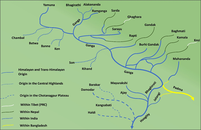
Figure 1: River line diagram of the GPS along with the major tributaries and distributaries.
Source: Authors’ own
The Ganga is joined by a number of tributaries which follow the topography and the slope of the terrain. In the Upper Ganga, all the tributaries like Bhagirathi, Alakananda, Ramganga, Yamuna and Ghaghara follow a NW-SE course that is consistent with the topography. The common features of the non-mountainous tributaries, including the Ramganga, include braided and meandering channels, sandy shoals that often experience inundation during the monsoon, and wide floodplains. The drainage pattern is predominantly dendritic.[6]In Middle Ganga Plains, the tributaries – Son, Gandak, Kosi and their tributaries, along with the Rapti, the Ghaghara and the main stream of the Ganga, tend to spill over in the monsoon and are dynamic. The Lower Ganga plains consist of the two major distributaries of the Ganga: the Bhagirathi and the Padma and their tributaries and distributaries. Apart from the Mahananda (which joins the Padma), all the other tributaries like Ajay, Mayurakshi and Damodar originate from the Chotanagpur region of eastern India and contribute water to the Bhagirathi/Hooghly channel (Figures 1 and 2).
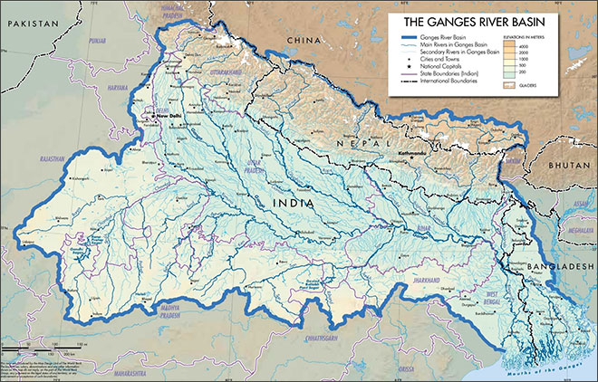
Figure 2: Basin enclosed by the GPS, showing drainage and physiography of the region.[xx]
Flooding in the Ganga-Padma system: Hydro-meteorological aspects
The rivers of the GPS are mostly perennial in nature, especially the ones that originate in the Himalayas. The water in these rivers is derived from the melting of Himalayan glaciers, the snow melt of the winter, and the monsoonal rainfall during the summer. The rivers that originate in the Central highlands and the Chotanagpur Plateau derive the bulk of their water only from the monsoons and have little flow during the summer. The distribution of monsoonal rainfall is variable across time and space. The basin is vast and almost a month is needed before the entire basin comes under the influence of monsoonal circulations. In Kolkata and the adjoining areas of Bangladesh, the monsoonal currents reach by the 5thof June, bringing torrential rainfall. The advance of monsoons continues and it reaches Delhi and further north of the basin around 1stJuly. The average monsoon precipitation is also varying in nature, with rainfall increasing from 360 mm on the western end to 800 mm in the central region, and 1200 mm to 1600 mm near the delta. In Nepal, the monsoonal precipitation is around 1500 mm, with theTerai regionexperiencing bulk of this rainfall as compared to the Himalayan part.[xxi]
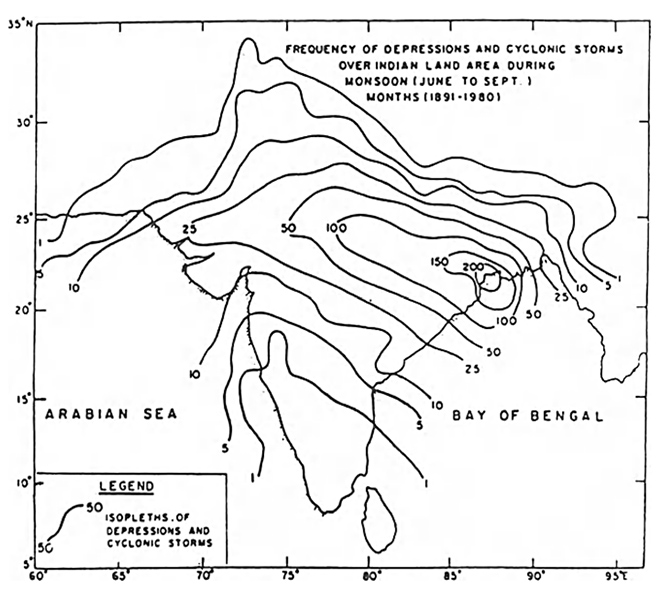
Monsoon high flows in the basin drained by the GPS, are caused when concentrated rainfall occurs over a significant period of time. This leads to the generation of flood run-off within the area that experiences precipitation. Most often, these rainfalls occur during the summer months (June to September) and are associated with the movement of monsoon depressions and cyclones. Most of these disturbances originate in the Bay of Bengal, and the frequency of the cyclonic depressions is higher in the east than in the west of the basin (Figure 3). These disturbances travel towards the northwest and west, cross the eastern coast, and often re-curve to move towards the north and northeast. They finally break at the foothills of the Himalayas after being influenced by western disturbances. Both the branches of the summer monsoon currents are also strengthened as a direct consequence of the movement of these cyclonic depressions, causing heavy to very heavy rainfall in the region over which they move.
Figure 3: Frequency of depressions and cyclonic storms.[xxii].
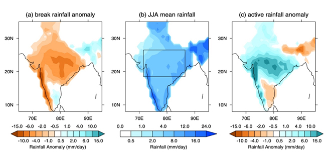
Another closely related monsoonal factor that leads to flooding in the North Eastern catchment of the GPS is linked to the phenomenon of “break monsoon”. This ‘break’ occurs due to the shift in the axis of the seasonal monsoon trough northwards from its normal position and a marked change in the lower tropospheric circulation over the monsoon zone. The vorticity above the boundary layer becomes anticyclonic.[xxiii]During the ‘break’ phase, the monsoon trough is located close to the foothills of the Himalayas and this results in intense rainfall over the Himalayan and Sub-Himalayan region, while the rest of the country faces drought-like condition. There is a clear deviation from the mean rainfall scenario or the scenario experienced during the active rainfall anomaly (Figure 4). This rainfall contributes to the flood runoff in the catchment of the rivers of northeast and the central Himalayas. This is primarily responsible for contributing to the high flows in the leftbank tributaries of the Ganga in Eastern UP and North Bihar. Furthermore, the Intergovernmental Panel on Climate Change (IPCC) synthesis report mentions that Climate Change has caused the number of monsoon break days to increase while decreasing the number of monsoon depressions. Simultaneously, the mean and extreme precipitation during the Indian summer monsoon is expected to increase with the Himalayan region experiencing the maximum increase.[xxiv]
Figure 4: Precipitation distribution during the monsoon season over 1969–2004 – (a) and (c) show the precipitation anomaly during the break and active phases respectively, relative to neutral periods; (b) shows the mean June, July, August (JJA) daily rainfall.[xxv]
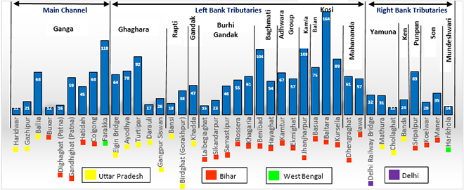
The frequency of floods is high in the Gauge/Discharge (G/D) sites along the left bank tributaries of the Ganga in Uttar Pradesh and Bihar, as well as the mainstream of Ganga between Ballia in eastern Uttar Pradesh and Farakka in West Bengal. This is evident from the flood frequencies at various G/D sites of left bank rivers like Ghaghara, Burhi Gandak, Baghmati, the Adhwara Group of rivers, Kamla Balan, Kosi and Mahananda. The Kosi basin experiences frequent flooding (Figure 5). Kosi, along with Ghaghra have large catchment areas which are shared between India, Nepal and China. Among the rivers that have relatively smaller basins and originate from the foothills of the Himalayas, Kamla Balan and Baghmati experience more frequent flooding. All these rivers further meet the Ganga at various stretches, causing the mainstream of the river to further swell, which leads to flooding in the downstream as seen in G/D sites at Colgong (Bhagalpur) and Farakka (Murshidabad).
Figure 5: Number of floods, of frequency 10 and above, recorded at different G/D sites of the GPS. (1986-2000).[xxvi]
Hydro-geomorphology of high flows in the GPS
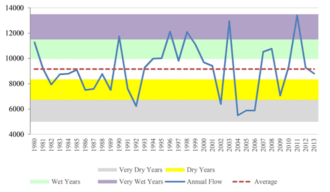
In spite of precipitation and the associated runoff being an important factor in the occurrence of high flows in the foothills and lowlands, inundation of riparian zones occurs only when the flow in a river channel exceeds itsbank-fullcapacity. Therefore, it becomes imperative to consider the complex and intimately related fluvial geomorphic processes resulting from high discharge in the riverine channels of GPS and its surface-subsurface linkages. These processes are mostly active during the summer monsoon season, when the rivers carry out a host of geomorphic functions like erosion, transportation and deposition. Variability in inter-annual discharge and intra-monsoonal high flow magnitudes is also an integral part of the fluvial regime of Indian rivers[xxvii](Figure 6). The high magnitude and frequency of high flows during the summer monsoons are instrumental in altering floodplain and channel morphology in the Ganga Padma System.
Figure 6: Annual Stream flow (measured at Farakka) for the Ganga River Basin showing Wet and Dry years.[xxviii].
Various studies point out that the magnitude of high flow is not as important for undertaking significant geomorphic changes as flood power.[7]Unit stream power or channel boundary shear stress is therefore a better measure of geomorphic effectiveness of a high flow than its magnitude.
During the instances of high flows exceeding the channel capacity, the power per unit area for large alluvial rivers like Ganga fall considerably as the width of the channels increase through overbank flows. The channel also widens as a result of bank erosion, thereby reducing the stream power per unit area. As far as boundary sheer stress is concerned, the values for Ganga, Yamuna and Kosi are between 11 and 25 N/m2.[xxix]High flows generating shear stress of 10 N/m2and above are capable of entertaining and transporting sediments of particle diameter 1cm.[xxx]Therefore, most large high flows that exceed the channel capacity in the Ganga and Yamuna basin are capable of moving sand and pebbles and even cobbles in the case of Kosi.
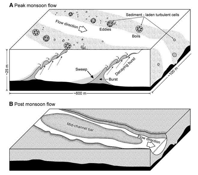
The flow characteristics in the alluvial channels of the GPS are different during the monsoons as compared to the subsequent season. A schematic three-dimensional view of the Ganga River (Figure 7) highlights this contrasting nature.[xxxi]In the peak monsoon flow scenario, the high-speed turbulent ejections containing bedload sediments move simultaneous upward from the riverbed and also downstream along the channel. Moreover, sediment-laden turbid river water moves parallel to the flow direction in the middle of the active channel. It acquires an elongated form and contain turbulent cells like boils and eddies. After the monsoon season, there is a significant drop in the discharge and this causes aggradation of the active channel bed through the deposition of a 5m to 10 m-thick sequence of bedload sediments leading to the creation of a mid-channel bar. The active flow shrinks and gets concentrated within a narrow channel passing through the sandbars.
Figure 7: Schematic showing change in flow during monsoon and post monsoon and associated behaviour of sediments.[xxxii].
The morphologic properties of rivers and their response to high flows in the Ganga Padma System are primarily dependent on where they originate. The rivers can be categorised into 3 groups: (i) mountain-fed; (ii) plain-fed; and (iii) foothills-fed.[xxxiii]The mountain-fed streams carry sediment load from upstream as the unit stream power is extremely high by virtue of the steep fall in gradient along the course of the river. The unit stream power and the shear stress decrease drastically as the river flow emerges from the mountain and onto the plains.[xxxiv]Moreover, due to high quantity of bedload and large fluctuations in discharge, the response to high flows exceeding the channel capacity in mountain-fed rivers becomes extremely volatile causing the streams to change their course. They also create a large fan as a direct consequence of their high locational instability. Such a morphological behaviour is observed in the principle left-bank tributaries of the Ganga that cause floods (Figure 5) except the Adhwara group. In contrast, the plain-fed and the foothills-fed rivers are highly sinuous and do not experience a large fluctuation in discharge or a very high sediment load. Overbank inundation and channel migration due to avulsion from the mainstream, control the morphology.[xxxv]
III. From monsoon high flows to floods: the anthropocentric dimension of a natural phenomenon
Coping with the natural variations in high flows (as seen in Figure 6) has always been an important characteristic of all human societies that have developed in areas experiencing inundation within the basin drained by GPS. The indigenous knowledge systems that existed in India had rationalised inundations as a necessity. Traditionally, people have harnessed the regenerative powers of floods while protecting themselves against its ravages.[xxxvi]These indigenous methods of adaptation to floods in the basin were being practiced by the rural communities since the 14thcentury.[xxxvii]
There was a clear distinction between the annual inundation due to high flows and the occasional deluge that disrupted life on the riparian zones. For instance, the people of lowland Bangladesh have developed their coping strategies around this principle, because of their experience in facing annual inundations orbarsha, which were a normal occurrence and severe inundations orbannawhich were largely occasional.[xxxviii]In eastern India, the annual inundations influenced the indigenous methods of water management by using the natural drainage, flood irrigation and open water fisheries. The high flows in the channels would be guided to individual land plots or would spread over the paddy fields as a consequence of discharge being more than the bankfull capacity. This water would deposit its load of fine, rich silt and algae, contributing to soil fertility. It would also replenish the groundwater while the water bodies on the floodplains would serve as settling ground for fish. In Burdwan, cultivation of fish in the various water bodies not only provided the people with protein, but also helped to regulate mosquito-borne diseases like malaria as these fishes would consume the larvae of mosquitoes.[xxxix]
British rule changed the strategy of “living with floods” with the creation of irrigation departments. The paradigm shifted to reductionism—the inundations were defined as “natural disasters”, necessitating their control and the containment of high flows within the river channel to prevent inundations. The construction of embankments served two purposes: to save standing crop from flood damage; and to reclaim more cultivable land in areas previously untouched. Although the construction of embankments did not entirely coincide with the advent of colonial administrative rule since embankments existed even prior to the Company’s accession to the Dewani, it certainly received a boost and expanded in a big way with the advent of colonial engineering strategies. Indeed, historians have found a nexus between the colonial administration and thezamindarsregarding the construction and management of embankments and the revenue sharing arrangements from expanding commercial agriculture[xl]. Apart from public embankments, European planters, indigo factory owners and bigzamindarsalso started constructing various marginal embankments to protect their economic interests in the floodplains. The ruthless manner in which the colonial administration would collect taxes, meant that more embankments had to be built and maintained by thezamindars.
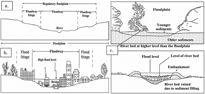
To this day, monsoon high flows are perceived as necessarily devastating, and embankments continue to be viewed as necessary for the protection of economic interests. However, human interventions to control riverine flood regimes have only accentuated the flooding. A river must have adequate space to carry out its functions; this space is defined by a river valley with an active floodplain.[8]The floodplain further consists of a floodway and flood fringes (together known as the regulatory floodplain) and other extended areas ( Figure 8a). A floodway is that part of the river valley which experiences at least once in a 100-year period an inundation of one-foot. Alternatively, a floodway conveys the highest discharge of the river at least once in 100.[xli]
Figure 8: Sketch map showing (a) various sections of the floodplain (b) manmade constructions on the floodplains and (c) the role embankments in raising the river bed[xlii].
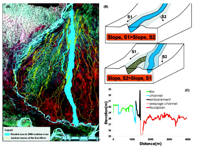
It is these floodway and flood fringes that have been traditionally encroached and used for agriculture. The construction of embankments has further agrravated the situation since the sediments start accumulating within the channel as the floodwaters can no longer utilise the entire floodway. This leads to raised channel beds in between the levees (Figure 8c), which causes catastrophic floods. It also leads to frequent channel avulsions as observed during the channel shifting event of Kosi in 2008 (Figure 9). A site becomes susceptible to experiencing channel avulsion when the slope of the potential channel became greater than the existing channel. In the case of Kosi, this happened due to extensive sedimentation at the avulsion site which led to the channel bed reaching a super-elevated condition.[xliii]Therefore, the gradient across the embankment became greater and this led to a breach of embankment and shifting of channel (Figures 8b and 8c).
Figure 9: The Kosi channel avulsion of 2018.[xliv].
Floods and their socio-economic impacts
Floods are among the major disasters in India, causing economic losses of more than $7 billion annually. The global assessment report (GAR) 2015 calls on the country to invest in Disaster Risk Reduction (DRR) and make investments for flood-resilient infrastructure.[xlv]
In the main Ganga river, its Himalayan (northern) tributaries, southern tributaries and tributaries joining before it falls in the Bay of Bengal, the major flooding events come from the Kosi, Ghagra and Gandak and their tributaries joining the Ganga along its course through Gangetic plains.[9] The same study observed a decrease in the frequency of floods in 1992, 2009, 2012, 2014, 2015, due to the severe drought condition across the country during those years, whereas maximum flood events were recorded during the years 1987, 1998, 1999, 2001, 2003, 2013.
Apart from innumerable social problems caused by floods, challenges for food security emerge as an important implication of the bank erosion and river migration in the region. For instance, in the upstream of Farakka Barrage up to Rajmahal in West Bengal, river bank erosion is posing a serious threat to food security, livelihoods, and income of farmers, especially the smallholders. Bank erosion in the basin is also leading to population displacement. Over 60,000 people are displaced each year due to riverbank erosion along the major rivers of the Ganga delta.[xlvi] This number is projected to increase in coming years due to increased rainfall caused by climate change which will increase the runoff into the Ganges-Brahmaputra systems.[xlvii]
In a flood risk assessment for the Ganges river basin, the World Bank group has developed an exposure database of population, buildings, infrastructure assets, and crops at sub-district/district level for Nepal, India and Bangladesh.[xlviii] The study estimated the value of total exposure in the basin at around INR 67,465 billion, of which India has the maximum share of INR 64,990 billion whereas Nepal and Bangladesh have INR 1,839 billion and INR 636 billion, respectively. The total exposure if divided with the total population of the basin stands at USD 1,970 per capita.
A major outcome of this study is the estimation of average annual loss (AAL) due to floods, which is highest for India (approx. INR 40,802 million), followed by Bangladesh (approx. INR 1,298 million), and Nepal (approx. INR 242 million). The Indian state of Bihar is shown to have maximum losses as most of the assets and the population in this state are in flood prone areas. The second most severely affected state in India is Uttar Pradesh (UP). It comprises almost all the sub-basins of the Ganges, i.e., Betwa, Chambal, Gandak, Ghagra, Gomti, Ken, Lower Ganges, Middle Ganges, Ramganga, Sind, Sone, Tons, Upper Ganges, and Yamuna. While Ghagra and Middle Ganges sub-basins have the maximum share in losses and flood affected persons in Uttar Pradesh. The study indicates that Bihar and UP states in India and areas of Bangladesh lying in the basin are highly vulnerable to the floods. At the sub-basin level, the Lower Ganges is the most severely affected sub-basin.
Further, direct losses are calculated for 2,5,10,25,50 and 100- year return-period flood scenario events and for all types of exposures at risk like residential, commercial, industrial buildings, essential facilities (schools, hospitals), infrastructure (rail and road networks), and major crops. For instance, for a Ganges river flood with a two-year return period, the number of people affected is found to be 47 million approx. (10 percent of the total basin population), while it is 67 million (14 percent of the total basin population) and 73 million (16 percent of the total basin population) with a 25- year and 100-year return period floods, respectively. In terms of the land inundated by a 100-year return period flood it is estimated to be 75,000 sq. kms and with a two-year return period an estimated 47,000 sq. kms of land is expected to be inundated. (Table 1)
Table 1: Most Severely Affected States and Provinces by flooding with a return-period of two years.[xlix]
State/province
Affected population
(in millions, and as %)
State/province
AAL
(in US$ millions)
Rajshahi, Bangladesh
0.99 (44%)
Bihar, India
221
West Bengal, India
3.53 (30%)
UP, India
205
Delhi, India
3.75 (22%)
Delhi, India
101
Bihar, India
18.12 (17%)
West Bengal, India
40
UP, India
17.31(9%)
Rajshahi, Bangladesh
14
Eastern Province, Nepal
0.15 (3%)
Eastern Province, Nepal
1
Mid-Western Province, Nepal
0.06 (2%)
Mid-Western Province, Nepal
1
The study also calls attention to the Lower Ganges basin which is the most severely affected sub-basin. The average annual losses in this sub-basin reach more than US$100 million, due primarily to damage to residential and commercial buildings and rice crops. Residential buildings alone account for nearly three-quarters of the total AAL. The other priority sub-basins, according to this study, are the Kosi, Bagmati, Ghagra, Gandak, Kamla- Balan, Middle Ganges, and Mahananda, which are also highly flood-prone.
Floods in the region not only cause economic losses but also impede the development of public infrastructure. The state of infrastructural development, especially public utilities, is extremely poor in the areas affected by flooding. For example, people living within the embankments of Kosi and blame the floodings for the lack of schools, roads, hospitals and other public infrastructure.[l]
In a separate assessment by the XI Plan Working Group, the areas affected by floods in the states of Bihar and Uttar Pradesh total 68.80 lakh hectares and 73.40 lakh hectares, respectively, which is 15.1 percent and 16.1 percent of the total flood affected area in India. Bihar is the most severely affected, with the total flood-affected area accounting for more than 69 percent of the state’s geographical area. The situation becomes particularly precarious as the density of population in Bihar is thrice than the India average – 1106 compared with 382 persons per sq. km. Moreover, Bihar is among the poorest states of India, with 43 percent of its population living below poverty line; it is 33rdamongst 34 states that were assessed on the basis of a composite index based on 13 socio-economic indicators. The ranking of Uttar Pradesh was only marginally better at 30[li]. Based on these estimates, it can be concluded that a significant share of the population is exposed to the risk of flooding and their inherent socio-economic makeup renders them particularly vulnerable to flooding. Being a transboundary basin, the region also requires active participation of neighbouring countries, particularly Nepal and Bangladesh.
V. Floods and society: Discourses on flood management
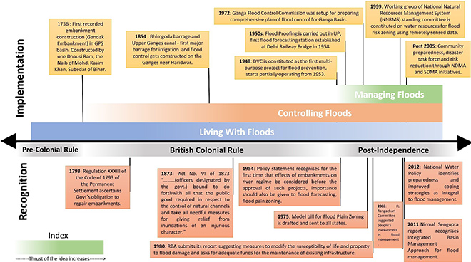
Three different viewpoints on floods and their relation with society have evolved over time. In all these views, high flows are seen as both beneficial and catastrophic and as a result human societies have developed the capacity to adapt both to the destruction caused by floods and the benefits of high flows. Yet the social dimension of its management is not always fully recognised. Traditionally, high flows were managed at the local levels by various types of community-based institutions which suggested that people co-existed with high flows (or in other words, they “lived with floods”.) To be sure, the nature of institutions was diverse depending on the climatic conditions, water endowments, physiographic characteristics of the specific areas and socio-economic characteristics of the people. Various scholars have found that local knowledge and management institutions for water management existed prior to British rule.[lii]
With the emergence of the departments of canals and irrigation during the British rule, these diverse local institutions were gradually replaced by modern engineering technologies that were used in European projects. This separated the local people from the decision-making process and the day-to-day management of rivers. The need for controlling floods[10]was felt for sustaining agriculture. River water was valued in terms of the revenue it could generate through irrigation. Moreover, protection from floods was seen as necessary for preventing the loss of standing crops. For example, the Permanent Settlement of 1793 established that thezamindarswould be considered as a crucial link between the East India Company and the countryside. They would facilitate the collection of revenue and establish the general agricultural relation. This act also explicitly recognised the government’s obligation to repair certain embankments. It also mentioned that thezamindarswould maintain some of the other embankments, according to custom, and if it was neglected, then the loss incurred due to flooding would be that of thezamindar’s. An important reason for forcing thezamindarsto build and maintain embankments was to ensure the avoidance of any difficulty in the process of revenue collection during instances when crops would get destroyed due to floods.[liii]
Post-independence India retained the reductionist paradigm of water engineering.[11]Large-scale water interventions in the form of extensive embankment construction, high dams, and large-scale water diversions were promoted in the GPS basin to meet the demands for irrigation water and hydroelectricity. The purpose of constructing these hydraulic structures was aimed to store and transfer surface water.[liv] Gradually, the idea ofliving with floodsceased being feasible due to damages caused by even normal inundations, not to mention the large-magnitude floods. These losses were the result of the increasing number of people, along with their associated economic activities, having moved into areas that were traditionally prone to natural inundation for the most part of the year. Coping with the natural variations in the river flows became a constant challenge for the Government and local communities. Inundations, particularly exceptionally long or flood levels which were unusually high, were then viewed as disasters that brought serious damage to the populations. In response, flood control boards were set up in some of the States in India.
Figure 10: Tracing the evolution of popular ideas for flood management.
Source: Authors’ own
They were tasked with assessing flood problems in the respective States, and also dealing with questions of policy and overseeing the planning and implementation of flood management activities. In India, flood control is the primary responsibility of the States. The flood management activities of the States can be broadly classified into four major groups:[lv]
Attempts to modify the floods
Attempts to modify the susceptibility to damage due to floods
Attempts to modify the burden of loss
Bearing of losses due to floods
To achieve success, the states have resorted to both engineering/structural measures and non-structural measures. Regardless of these measures, providing permanent immunity against floods is not techno-economically feasible. The sustainability and efficiency of massive embankment construction as a permanent flood defence has come under serious debate, especially in the rivers carrying heavy silt concentrations like the Ganga. The floods in Kosi basin during 2008 and Mahanadi basin during 1961, 1982, 1994, 2001, and 2010 are the striking examples of embankment breach and ineffective reservoir operation, respectively. Interestingly, in 1952, Bihar had only 160 kms of embankment length with flood-prone area of 2.5 million ha and after the construction of nearly 3,500 km embankments, the flood-prone area increased to 7.1 million ha.[lvi][lvii]
The role of dams in moderating the impact of floods in the downstream has repeatedly gained currency. One such proposed dam is the Kosi High Dam (also known as the Sapta Kosi High Dam Multipurpose Project), which has been part of policy discussions since 1953 when the first feasibility report was completed. A major objective of this project is to control flooding in the downstream Terai regions of Nepal and India. However, this will have only a marginal impact in controlling the flood peaks of the Kosi as the reservoir will only be able to accommodate 9.5 billion m3of water out of the average annual flow of 55 billion m3[lviii]. Moreover, the 4.08 billion m3of dead storage of the proposed reservoir will be filled with sediment in 35 to 40 years.[lix]Various scholars have pointed to a lack of understanding of the geographical and hydrological characteristics of the region.[lx][lxi]Downstream of the proposed high dam, Nepal’s terai region extends for about 40 km and consists of various rivers that can be considered as ‘non-point flood sources’ that add to the flood inundation of the middle and lower Terai region. Therefore, the floods in the basin are caused by intense localised rainfall, as opposed to the mainstream view of peak flows from the ‘point-sources of flood’ overtopping embankments in the major tributaries where large storage infrastructures are proposed.
Despite the various steps undertaken over the last six decades, the trend of increasing damage and devastation brought by floods continues to pose a challenge to the Government. Over time, several expert committees have reviewed the progress of engineering works in controlling floods. These committees also suggested river flow modulation to meet competing demands for water from agriculture, urban, industry and energy sectors. It is now well-realised in the policy circles that floods cannot be controlled entirely through structural measures; that they have to be managed in order to minimise the damages caused by catastrophic flood events. In this respect, flood plain mapping and zoning have been initiated, but, so far, integration of flood monitoring and mapping into existing flood management has not succeeded. Methods of flood relief, such as early flood warning systems and flood recovery measures, have not been effectively implemented. An adequate combination of structural and non-structural flood protection measures, together with damage mitigation measures need to be included in the flood management[12]approach. Likewise, sediment management has also been a challenge that has not been adequately addressed in the policy arena. The draft policy on sediment management (2017), prepared by the Ministry of Water Resources, River Development and Ganga Rejuvenation identifies the importance of lateral connectivity of river with its flood plain as an important component of sediment management. It emphasises constructing sluice gates along stretches of embankments that would allow the sediment to be deposited on the floodplains and also contribute to the various provisioning services of floods like the recharge of groundwater and rejuvenation of water bodies.
The many dimensions of this complex and interlinked social and ecological system has been explained with help of a schematic, representing the causal loops (Figure 11). The broad dimensions can be understood as: Bio-geo-physical; social and economic outcomes; and institutional measures to manage floods. Together, with these three broad dimensions, the interlinkages are also categorised on the basis of their polarity (negative if the relationship is inverse, positive if it is direct) and whether the effect is seasonal and subsequent to the cause or if it is cumulative and is operational over a period greater than a season. A systems’ perspective is important for understanding the multi-faceted dimensions of floods and its implications. The interplay of the varied elements from the three broad categories that have been mentioned above, render a distinct character to the occurrence of flooding in the GPS. The IFM approach for this basin should reflect such a systemic understanding and any possible management strategy should undertake a detailed assessment of both – the forward and backward implications. [13]
Figure 11: Causal Loop Diagram around floods in the GPS
Source: Authors’ own
VI. A new perspective to flood management
Big floods are seen as natural catastrophic events, causing large-scale damage to life and property.[lxii]The same perspective views floods of small magnitude as desired and manageable, while large floods are problematic. This is because in addition to damages caused by floods, communities resist the unwanted water, which at times could lead to violent conflicts. Conflict in the context of floods can be defined as contradictory perceptions (between centre and state; state and non-state actors; vulnerable and secure groups; and amongst vulnerable groups) about the course of action to overcome the catastrophe.[lxiii]
Floods need to be understood from an ecological perspective. Human-induced changes that disrupt ‘way of the river’ not only contribute to increased flood velocities but also impair rivers from providing benefits to human society. Such interventions, by manipulating the flow of water alter channel pattern, increase flood risk, constrain navigation and cause changes to aquatic and riparian ecosystems. There is mounting evidence that these structures are, ironically, increasing flood magnitude and frequency. Indeed, these interventions have not only led to greater exploitation of river valleys, they have also impaired many of the natural functions of rivers by diminishing the ecological rejuvenation provided by flooding.
Floods are important ecological agents that influence the productivity of rivers and its associated flood plains. Floods create new habitat and alter resource distributions via transport and/ or deposition of sediment, woody debris and nutrients. Some species rely on floods to complete their life cycles. During flood events, water and sediment are transported onto the floodplain and provide the nutrients that render river ecosystems highly productive. Flooding can also provide many benefits, including recharging groundwater, increasing fish production, creating wildlife habitat, recharging wetlands, constructing floodplains, and rejuvenating soil fertility.[lxiv]One of the dominant paradigms in large-river ecology, the flood-pulse concept, explicitly incorporates the importance of flooding for riverine ecosystem productivity. Modification of natural flood regimes through the construction of levees, floodwalls, dams can significantly modify ecological processes and change ecosystem structure and function, depending on species characteristics and on the specific type of flood alteration. The ecology of floods is complex and intimately related to the rainfall-runoff and surface-subsurface hydrologic linkages.[lxv] These linkages are critical for long-term sustainability of landscape heterogeneity, biodiversity conservation and ecosystem services.
Integrating natural infrastructure (e.g. wetlands, floodplains) into flood protection management has the potential to benefit communities. This aspect is necessary and missing in the present flood management approach in India. Recognising the importance of natural infrastructure to human society, it is crucial to address certain questions: Why do flood plain loss and river channelisation occur? Could this be because the value of flood plains is often considered to be negligible, even negative, in many decision-making contexts.[lxvi]This could also be because the costs of conservation and the benefits of avoided damages are realised by different groups. The costs of flood inundation are often spread among many downstream property owners and insurance agencies, whereas the opportunity costs of conserving wetlands are borne by relatively few upstream landowners and municipalities. Benefits of reconnecting rivers to their floodplains are potentially quite large, and that the omission of ecosystem service outcomes from land use decisions may have real and severe consequences for people in the long run.
That said, achieving absolute flood protection is an illusion.[lxvii]However, flood-related losses can be reduced through an adequate combination of structural and non-structural flood protection measures, together with damage mitigation measures included in the IFM approach. The IFM approach derives its principles from the Integrated Water Resources Management (IWRM) approach and integrates land use management, and risk management. Where it considers restoring and maintaining comprehensive environmental flows (e-flows) in a river basin as one of the keystones to implementing an integrated management of water resources. The other key element of the approach is developing people-focused, end-to-end early warning systems, which include both technical and societal considerations. The main pillars of this approach are reducing exposure and vulnerability of the population, and the built environment to floods.
The IFM is an adaptive management approach that suggests changing actions and plans according to outcomes from the established knowledge base that deals with scientific uncertainties and provides the best combination of strategies that are sustainable and resilient to expected changes. Climate change-induced changes in the flows are a major source of uncertainty and, therefore, the associated assumption that present flood protection engineering works would withstand the future hydrological regime. This is so because of the fact that the scale of future hydrological conditions cannot be predicted with certainty under already changing climatic conditions. The IFM shifts focus from traditional flood protection towards more flood-resilient solutions that are aware of the challenges posed by anthropogenic causes and climate change.
A successful IFM implementation requires inputs from different stakeholders including government, public, technical and management and coordination at all levels of authority within the basin and between sectors. The approach stresses on (1) local and community capacity building as necessary to meet the IFM requirements, (2) sharing and management of information as a precondition for an efficient IFM approach. In the case of transboundary rivers like Ganga, the exchange of flood data is necessary for the implementation of a flood preparedness plan for downstream riparian countries, and finally, (3) involvement of various sectors in the decision-making process. Unfortunately, this approach, so far, has not been fully adopted in India.
The Associated Programme on flood management (APFM), a joint initiative of the World Meteorological Organization (WMO) and the Global Water Partnership (GWP), is promoting the concept of IFM. The objective of this programme is to facilitate dialogue and provide government agencies with guidance on flood management for the implementation of IFM national strategies.[lxviii]India can gain from initiating dialogues with WMO and GWP to promote principles of IFM in its flood management approach.
In a positive move towards implementing IFM effectively, environmental flows estimation has recently been introduced in Lohit, Alaknanda-Bhagirathi and Bichom sub-basins in India.[lxix]However, according to Anantha and Dandekar (2012) these assessments have been arrived at without considering community needs or keeping ecological and livelihood needs as a priority. Even though significant progress has been made in developing policies and laws to recognise environmental flow needs, an understanding of environmental flows as a public policy imperative is a comparatively recent development. This calls for a meaningful integration of good science and policy and enabling institutional framework, to put E-flows in a proper context as one of the means to ensure the ecological health of the already dammed rivers.
VII. Conclusion
Recurring floods in the Ganga-Padma river basin have historically been understood as a technological problem that requires techno-centric solutions such as diversion of river flow and construction of river embankments. Embankments, however, have been found to cause sediment deposition in riverbeds, increasing the risk of embankment breach and flooding even during normal-flow stages. Floods continue to occur and displace millions of families in the Ganga basin.
The imperative is for a proactive approach involving interdisciplinary research, dialogue, planning, implementation, and monitoring in order to understand the complex interactions between human vulnerability and ecosystem processes. The consequences of floods can be minimised by following management practices that are based on the principles of Integrated Flood Management of multi-level governance, management that is adaptive in nature, accounts for multiple interest within the flood management process and is aimed at increasing or restoring ecological services of riverine ecosystem. Stronger political will is needed to implement hard measures like flood-plain zoning that would even result in displacing and dislocating people in the short term, only to prevent them from the agonies of flood in the long term.
Climate change and climate-induced extreme weather events are ongoing processes that pose additional challenges to the adequacy of the present flood protection engineering works to withstand the future hydrological regime. It is projected that the average precipitation levels in the Ganga Basin will increase by approximately 20 percent and heavy precipitation events are likely to increase flood risk in the basin. The Ganga basin is also expected to experience increase in temperatures, resulting in the retreat of glaciers; increase variability in precipitation, resulting in increased magnitude and frequency of droughts and floods.[lxx]On the Indian side of the basin, over all, the hydrological cycle is predicted to be more intense, with higher annual average rainfall as well as increased drought. According to the Fifth Assessment Report of the Intergovernmental Panel on Climate Change (IPCC), the average seasonal rainfall of the South Asian monsoon is expected to increase along with its duration and variability. This may lead to larger modulations in extreme conditions such as periods of drought or increased flooding.[lxxi]This will have implications for a huge section of the basin population that is dependent on agriculture, which is climate-sensitive.
Monsoon high flows are intrinsic to the nature of rivers flowing from the Himalayan region and onto the Gangetic plains. These riverine flows need to be viewed from a holistic perspective of putting the ecological needs of the rivers and their floodplains at the forefront while considering the economic interests at the same time.
References
[1]High flows can be understood as part of the natural pattern of hydrological variability in riverine channels, and are often a consequence of monsoonal precipitation that may or may not be more than the bankfull-discharge. High flows are integral to the proper functioning of riverine ecosystems. High Flows are an essential element of the hydrological cycle and important for the delivery of ecosystem services related to rivers.
[2]Environmental flows are described as the quantity, quality and timing of water flows required to sustain ecosystems and the valuable services they provide to human beings.
[3]In this study, the term “high flows” is not interchangeable with “floods”. Floods are high flows that are always greater than thebankfullcapacity and are necessarily damaging.
[4]IFM is a holistic approach that combines structural and non-structural strategies covering all aspects of the flood timeline: preparedness; prevention; protection; mitigation; recovery; and post-flood updating.
[5]Padma River is the downstream of the Ganga, more precisely, the combined flow of the Ganges and the Jamuna after their confluence at Goalandaghat. In Bangladesh the Ganges is popularly known as the Padma from its point of entrance at Manakosa and Durlabhpur unions of shibganj upazila, nawabganj district. This name (Padma or Podda) is sometimes applied to the Ganges as far up as the point at which the Bhagirathi leaves its right bank, and according to the Hindus, it takes the sanctity of the Ganges with it. In this paper, Padma river would be understood as the main channel of the Ganga from the point of its entrance into Bangladesh.
[6]A dendritic stream pattern is the most common type and it resembles the scattered branches of a tree joining the trunk. It is irregular in its arrangement with tributaries joining larger streams at acute angles (less than 90°). Water flow in this spatial arrangement is highly efficient and receives very little resistance from the underlying rock structure.
[7]Flood power is identified as the boundary shear stress exerted by high flows to entertain the bed sediments and to exceed the resistance provided by the bed and bank.
[8]The active floodplain is defined as an area on either side of a stream or river which is regularly flooded on a periodic basis, the return period of the flood being 2.33 years (GRB EMP, 2010)
[10]Controlling floods – The process of constructing embankments or dams or carrying out other structural measures like channelisation of rivers, channel and drainage improvement, diversion of flood waters and watershed management, which are explicitly directed towards controlling and regulating floods in the floodplains.
[11]The popular discourses on flood management, post-independence, discussed in this section are pertaining to those that have evolved only in India. This has been done because a large part of the basin, along with the maximum flood affected area within the basin, is located in India. Moreover, being the forerunner in developing the capacity for flood management, it has shaped the policy discourse in South Asia and influenced the adoption of flood management approaches in Nepal and Bangladesh.
[12]Managing floods – A conjunctive mix of structural and non-structural interventions for flood risk management along with resilience building of communities living in flood-prone areas for enhanced capacity to cope with floods.
[13]*Dams and detention basins, for this purpose, are solely meant to alter the timing of a steep increase in river discharge due to rains in the upstream catchment. This is in contrast to another institutional measure – ‘diversion of flood waters’ for which dams are solely used to divert the flow from the original channel.
[i]Haeuber, Richard A, and William K Michener. 1998. “Natural Flood Control.”Issues in Science and Technology15 (1): 74-80
[ii]Talbot, Ceara J., Elena M. Benett, Kelsie Cassell, Daniel M. Hanes, Elizabeth C. Minor, Hans Paerl, Peter A. Raymond, et al. 2018. “The Impact of Flooding on Aquatic Ecosystem Services.”Biogeochemistry141: 439-461
[iii]Bandyopadhyay, Jayanta. 2009,Water, Ecosystems and Society: A Confluence of Disciplines. New Delhi: SAGE Publications India Pvt Ltd.
[v]Dulal, Hari Bansha. 2014. “Governing Climate Change Adaptation in Ganges Basin: Assessing Needs and Capabilities.”International Journal of Sustainable Development & World Ecology 21(1):1-14.
[vi]World Bank. 2014. Ganges Strategic Basin Assessment: A Discussion of Regional Opportunities and Risks, Report No. 67668-SAS. Washington DC.: The World Bank.
[vii]Rahman, Kazi Saidur, Zahidul Islam, Umme Kulsum Navera, and Fulco Ludwig. 2019. “A Critical Review of the Ganges Water Sharing Arrangement.”Water Policy21: 259-276.
[x]Singh, Omvir, and Manish Kumar. 2017. “Flood Occurrences, Damages, and Management Challenges in India: A Geographical Perspective.”Arabian Journal of Geosciences10 (5): 1-19.
[xi]Dewan, Ashraf, Robert Corner, Ashty Saleem, Md Masudur Rahman, Md Rafiqul Haider, Md Mostafizur Rahman, and Maminul H. Sarker. 2017. “Assessing channel changes of the Ganges-Padma River system in Bangladesh Using Landsat and Hydrological Data.”Geomorphology276: 257-279.
[xiii]Nandargi, Siddharth Suresh, and Akash Shelar. 2018. “Rainfall and Flood Studies of the Ganga River Basin in India.”Annals of Geographical Studies1(1): 34-50.
[xix]Topalovic, Zana, and Durica Markovic. 2018. “Integrated Approach to Flood Management.” In Integrated Urban Planning: Directions, Resources and Territories, by KLABS. TU Delft Open: 143-169.
[xxi]Rutz, Cynthia Lillian. 1997. “Modelling the Effects of Climate Change on Flooding in Bangladesh.” Unpublished PhD diss.,International Global Change Institute (IGCl), University of Waikato, Hamilton, New Zealand.
[xxii]Dhar, O. N., B. N. Mandal and P. R. Rakhecha. 1984. “Rainfall Distribution Over India During the Monsoon months in the Absence of Depressions and Cyclonic Storms.”Mausam35(3): 309-314
[xxiv]Rohekar, Jemima. 2017. “What IPCC Says About India.”Down To Earth, April 17, 2017.
[xxv]Dunning, C. M., A. G. Turner, and D. J. Brayshaw. 2015. “The Impact of Monsoon Intraseasonal Variability on Renewable Power Generation in India.”Environmental Research Letters10, no. 6: 064002.
[xxx]Komar, P. D. 1988. “Sediment Transport by Floods.”Flood Geomorphology: 97-111. Planetary Geology Program of the NASA Grant NSG-71718.
[xxxi]Singh, M., I. B. Singh, & G. Müller. 2007. “Sediment Characteristics and Transportation Dynamics of the Ganga River.”Geomorphology, 86(1-2): 144-175.
[xxxiii]Sinha, R., and P. F. Friend 1994. “River Systems and Their Sediment Flux, Indo‐Gangetic plains, Northern Bihar, India.”Sedimentology, 41(4): 825-845.
[xxxiv]Kale, V. S. 1998. “Monsoon Floods in India: A Hydro-geomorphic Perspective”.Memoirs-Geological Society of India: 229-259.
[xxxv]Sinha, Rajiv. 1996. “Channel avulsion and Floodplain Structure in the Gandak-Kosi Interfan, North Bihar plains, India.”Zeitschrift Fur Geomorphologie Supplementband: 249-268
[xxxvi]Bandyopadhyay, Jayanta, and Dipak Gyawali. 1994. “Himalyan Water Resources: Ecological and Political Aspects of Management.”Mountain Research and Development14 (1): 1-24.
[xxxvii]Hughes, R. S. Adnan and B. Dalal-Clayton. 1994. “Floodplains or Flood Plans?A Review of Approaches to Water Management in Bangladesh.” London: IIED.
[xxxviii]Nasreen, M. 1999. ‘Coping with Floods: Structural Measures or Survival Strategies?’ InLiving with Floods-An Exercise in Alternatives, edited by Imtiaz Ahmed, 32–39. Dhaka: University Press Limited.
[xxxix]Mishra, Dinesh Kumar. 2001. “Living with Floods: People’s Perspective.”Economic and Political Weekly: 2756-2761.
[xl]Singh, P. 2003. “Colonising the Rivers: Colonial Technology, Irrigation and Flood Control in North Bihar, 1850 1950.” PhD diss., Jawaharlal Nehru University, New Delhi, India.
[xli]Coats, D. R. 1973.Environmental Geology and Landscape Conservation: 360.
[xlii]Valdiya, K. S. 2011. “Bracing for Flood Hazards.”Current Science(Bangalore) 101, no. 1 : 16-17.
[xlvi]Dewan, Ashraf, Robert Corner, Ashty Saleem, Md Masudur Rahman, Md Rafiqul Haider, Md Mostafizur Rahman, and Maminul H. Sarker. 2017. “Assessing channel changes of the Ganges-Padma River system in Bangladesh using landsat and hydrological data.”Geomorphology257-279.
[xlviii]Satya, Priya, William Young, Thomas Hopson, and Ankit Avasthi. 2017. Flood Risk Assessment and Forecasting for the Ganges-Brahmaputra-Meghna River Basins. Washington, DC: World Bank.
[l]Mishra, Dinesh Kumar. 2008. ” The Kosi and the Embankment Story.”Economic and Political Weekly: 47-52.
[li]Kumar,Santosh, Arun Sahdeo, and Sushma Guleria. 2013.BIHAR FLOODS : 2007 (A Field Report). National Institute of Disaster Management, Ministry of Home Affairs, New Delhi. Accessed July 15, 2019.
[lviii]Sadoff, Claudia, Nagaraja Rao Harshadeep, Donald Blackmore, Xun Wu, Anna O’Donnell, Marc Jeuland, Sylvia Lee, and Dale Whittington. 2013.”Ten Fundamental Questions for Water Resources Development in the Ganges: Myths and Realities.”Water Policy15, no. S1 : 147-164
[lix]Dixit, Ajaya. 2009. “Kosi Embankment Breach in Nepal: Need for a Paradigm Shift in Responding to Floods.”Economic and Political Weekly: 70-78.
[lxiii]Prasad, Eklavya, K. J. Joy, Suhas Paranjape, and Shruti Vispute, . 2012. Agony of Floods: Flood Induced Water Conflicts in India. Pune: Forum for Policy Dialogue on Water Conflicts in India.
[lxiv]Poff, N. Leroy. 2002. “Ecological response to and Management of Increased Flooding Caused by Climate Change.”Philosophical Transactions of the Royal Society of London:1497-1510.
[lxvi]Turner, Kerry. R., C J M.Jeroen, Van den Bergh, Tore Soderqvist, Aat Barendregt, Jan van der Straaten, Edward Maltby, Ekko C Van Ierland. 2000. “Ecological-economics Analysis of Wetlands: Scientific Integration for Management and Policy.”Ecological Economics35:7-2
[lxx]Hosterman, Heather R., Peter G. McCornick, Elizabeth J. Kistin, Anju Pant, Bharat Sharma, and Luna Bharati. 2009. Water, Climate Change, and Adaptation: Focus on the Ganges River Basin. Nicholas Institute for Environmental Policy Solution, Working Paper NI WP 09-03, Duke University.
The views expressed above belong to the author(s). ORF research and analyses now available on Telegram! Click here to access our curated content — blogs, longforms and interviews.
Preeti Kapuria was a Fellow at ORF Kolkata with research interests in the area of environment development and agriculture. The approach is to understand the ...
Sayanangshu Modak was a Junior Fellow at ORFs Kolkata centre. He works on the broad themes of transboundary water governance hydro-diplomacy and flood-risk management.

 PDF Download