-
CENTRES
Progammes & Centres
Location
The Indian Army needs to move with great alacrity to secure drone capabilities that are operable in GPS-denied combat environments to counter any attacks from its adversaries.
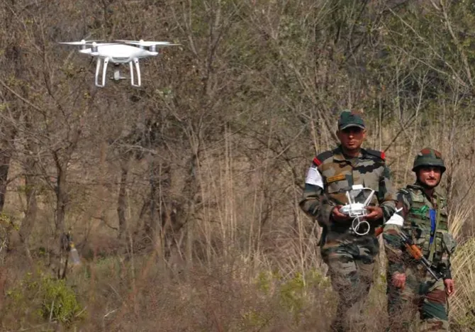
The Indian Army (IA) recently announced a move to replace mules and choppers with drones for supplies along the Line of Actual Control (LAC) in Ladakh, Leh, and Northeastern India. The Unmanned Aerial Vehicles (UAVs) will supply medicines and food to troops in remotely deployed forces or Border Observation Posts (BOPs). Fitted with proximity sensors, these UAVs can fly in all weather conditions and they are all GPS-guided. This latest use of drones by the IA comes against the backdrop of the IA’s operational deployment of dedicated UAVs for Intelligence, Surveillance, Reconnaissance (ISR) missions in Eastern Ladakh and along the Sino-Indian boundary in 2022. Serving as force-multipliers, these latter set of drones are Artificial Intelligence (AI)-enabled, making them capable of communicating with each other while coordinating and supporting close air-to-ground operations for the IA’s infantry, mechanised infantry, mobile artillery and armoured formations. In addition, the Automatic Target Recognition (ATR) system that they are equipped with can identify a whole range of targets including enemy artillery units, tanks, infantry formations, and static installations.
The Unmanned Aerial Vehicles (UAVs) will supply medicines and food to troops in remotely deployed forces or Border Observation Posts (BOPs).
For peacetime missions and tasks, the UAV capabilities listed above that the IA has deployed/deploying—involving drone substitution for animal transport and manned rotary aircraft— are undoubtedly indispensable. But the IA’s drone use, which is significantly satellite-dependent to secure logistics requirements, will be tested in wartime as they are very vulnerable to attacks by India’s principal adversaries—the Peoples Republic of China (PRC) and Pakistan.
While the adoption and integration of drone capabilities is necessary and commendable, these UAVs are Global Positioning System (GPS)-enabled, leaving the IA unprepared for operations in GPS-denied environments. This is true for any Global Navigation Satellite System (GNSS)—including India’s limited seven satellite navigation system called the Navigation with Indian Constellation (NAViC) and China’s BeiDou satellite navigation system. GNSS constellations enable precise Position, Navigation, and Timing (PNT) services through the transmission of signals for the IA’s UAVs. Disruption to signal relays from GPS satellites and India’s own NAViC constellation to the IA’s drone clusters geared for supply delivery will be a challenge in wartime. Jamming and spoofing are the real threats to GPS-reliant systems whether drones, artillery or missiles. As the wars between Azerbaijan and Armenia and especially the Russia-Ukraine conflict have visibly and incontrovertibly demonstrated, electronic jamming is amongst the deadliest forms of attack against ISR UAVs. Spoofing is another form of attack, which involves feeding false signals by way of simulating the GPS signal of the enemy and capturing the adversary’s receiver thereby diminishing the accuracy of munitions. The IA has already purchased the GPS or satellite-dependent Israeli medium altitude long endurance drones called the Hermes Starliner 900 drones for communication surveillance missions dedicated to India’s contested frontier with China.
Jamming and spoofing are the real threats to GPS-reliant systems whether drones, artillery or missiles.
Thanks to the latest move by the IA, the deficiency of wielding and using UAVs capable of operating independently of satellites, is being addressed. The service has started testing UAVs that can operate in GPS-denied environments precisely to meet the ISR, logistics and loitering munition strike capabilities for the IA’s unmanned aerial vehicles. The Nagastra-1 loitering munitions dropped from SWARM drones built by the Bengaluru-based NewSpace Research were able to strike their targets with great accuracy without satellite guidance. However, more testing will be necessary for satisfactory integration by the IA. Further, on a cautionary note, drone constellations that are lost partially during actual combat operations and in battlefield conditions must be capable of communicating with each other. Assuming one-fifth of the drones are destroyed in a 30-drone cluster geared for ISR and strike missions or a combination of both, the remainder must be capable of executing the mission. It is unclear whether the AI-driven drones built by Bengaluru-based NewSpace Research and Technology and the Noida-headquartered Raphe mPhibr Private Limited, which the IA’s armoured corps and mechanised infantry have purchased, are fully capable of performing tasks and mission sets if a segment of the drone swarm is damaged or destroyed due to enemy action during battlefield operations. Further, do the drones specifically built by the Indian start-ups for the IA have Inertial Navigation System (INS) capabilities and are they paired to a spoof resistant GNSS receiver with high resilience? Do the sensor arrays, cameras and software of these UAVs the have capacity to know their position in relation to their surroundings without the assistance of GNSS or GPS?
The Nagastra-1 loitering munitions dropped from SWARM drones built by the Bengaluru-based NewSpace Research were able to strike their targets with great accuracy without satellite guidance.
Thus, unless there is clarity with regard to these questions, the IA may still have some distance to travel to create a high level of redundancy geared for GPS-denied drone missions and operations. If its drone-based logistics forces are going to be as GPS-dependent as they are today, it will, at a minimum, constrain, and at a maximum, imperil its ground forces during active military operations. Therefore, the task that confronts the IA is that it needs to move with great alacrity to secure drone capabilities to meet the logistics requirements that are not dependent on GPS because the IA’s logistical nodes whether airborne or ground-based will be a prime target for the Peoples Liberation Army-Army (PLAA), Peoples Liberation Army Strategic Support Force and the Peoples Liberation Army Air Force (PLAAF). As of now, at least from the foregoing, it is unclear or not evident at all that drones designed for logistics missions for the IA are capable of functioning and operating independently of GPS. This applies equally to all the drone sets of the IA geared for ISR and attack missions, which must be fully rendered capable of operating effectively in GPS-denied combat environments. Finally, the IA and the Indian armed services generally will need to strengthen their own electronic warfare systems and spoofing attack capabilities to effectively counter the PRC and Pakistan’s GNSS-enabled UAVs.
Kartik Bommakanti is a Senior Fellow with the Strategic Studies Programme at the Observer Research Foundation
The views expressed above belong to the author(s). ORF research and analyses now available on Telegram! Click here to access our curated content — blogs, longforms and interviews.

Kartik is a Senior Fellow with the Strategic Studies Programme. He is currently working on issues related to land warfare and armies, especially the India ...
Read More +