At the Belt and Road Initiative Summit 2019, the Chinese Ministry of Commerce displayed a map of BRI routes which showed all of Jammu and Kashmir, and Arunachal Pradesh as a part of the Indian territory. To many, this was a curious development, as a month earlier various news agencies had widely reported the destruction of nearly 30,000 maps that depicted Arunachal Pradesh as part of India. China is not prone to ‘errors’ of this nature, and though the map was later taken down from the government website, it has led to the speculation whether this was a deliberate move by the Chinese government to earn some goodwill of India, given Delhi’s boycott of the BRI Summit for the second time in line.
Slip or no slip, the reports once again underscore the relevance of maps in a seemingly borderless world, driven by technology, and speed of light communication that allows the easy travel of information and ideas between nations and their peoples. After all, maps are not neutral, irrespective of the purpose for which they are used. The very act of referring to a country’s map is often a political statement.
Borders and cartography
Throughout history, borders of kingdoms have always been vague, slightly grandiose declarations of the presiding ruler’s military conquests. The story of drawing borders is closely linked with the history of cartography, following the dawn of the renaissance and the rise of nationalism. Actual borders outlining every nation on Earth do not exist, and yet they persevere in being the cause for conflict, for war and bloodshed. A map depicts these fractured lines that define national identity, and thus becomes inherently political.
Actual borders outlining every nation on Earth do not exist, and yet they persevere in being the cause of conflict.
A
third of the modern borders are mostly the result of colonisation — India’s own border with Pakistan and Bangladesh was drawn by Lord Cyril Radcliffe, a man who had never previously visited India and who had just five weeks to finish the task of demarcating lines that would create two separate countries. The shadow of colonisation still hangs over many of the border conflicts in the African continent — it took 30 years to settle the conflict between Congo and Uganda — and many other similar wars rage on.
In
a map that depicts the various disputed territories across the globe, more than three quarters of all these countries are engaged in some sort of dispute over national territory, and the idea of what constitutes a nation’s borders. Modern borders are
blood meridians — and in the age of the internet, drawing lines on a digital map is bound to cause sparks.
Appeasement cartography and border conflicts
In 2010, news outlets
widely covered an event in which Nicaraguan troops marched into Costa Rica and set up camp on a 2.7 km stretch of land. When asked about the incursion, Commander Pastora replied that based on a Google map of the region, the stretch was Nicaraguan territory. Tensions flared and the border security forces were deployed; the issue was resolved only when the tech giant apologised for the error.
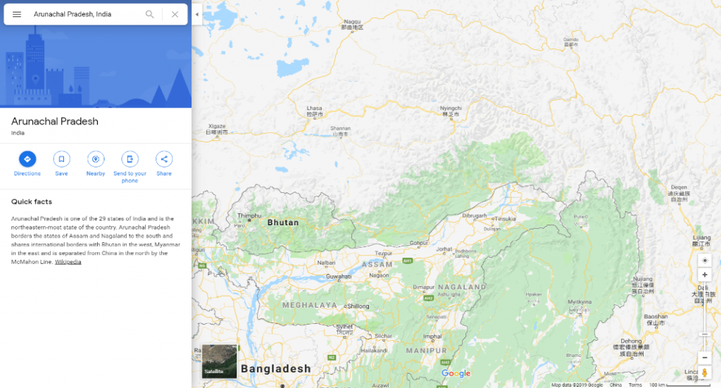
Google maps has a prickly history with depicting borders on the internet — for the most part, the company has been compliant with national laws regarding the depiction of borders. For instance, Google maps when accessed in India shows Arunachal Pradesh as one of the states in the Northeast — but when we access the same map from China, it shows Arunachal Pradesh is absorbed into China’s territory.


The decision to show differing maps was made in 2009 as a way to placate both India and China over the backlash caused by the previous version of the map, and the strain following Prime Minister Manmohan Singh’s visit to Arunachal Pradesh during the state elections. However, even if Google has a method of assuaging the political ramifications of its cartography, it still suffers from certain peculiarities in the depiction of borders in areas of conflict. An
article by the Irish Times highlighted that using Google maps to navigate a route from Ireland to the UK alerted the user that ‘This route crosses a country border’; however, while showing the route from Tel Aviv to an Israeli settlement in the West Bank no such alerts are displayed, despite the fact that the route involves crossing Israel’s recognised Green Line border.
Google maps has a prickly history with depicting borders on the internet — for the most part, the company has been compliant with national laws regarding the depiction of borders.
In India, when searching for a route from Demchok, a military encampment in the Leh district to Gar Post Bureau Office in the Ngari prefecture of Tibet Google informs the user that it takes around an hour and forty-five minutes to cover a distance of 89 kilometres. Apart from a notification that ‘Your destination is in a different time zone,’ no alert regarding the border crossing is displayed. However, the
Chinese version of Google Maps places Demchok squarely inside China’s borders, and does not show any information on a route from the same to the Ngari prefecture. Trying to find a route from other villages around Demchok also leads to no results. Clicking on the village for more information, curiously enough, causes the map to show a portion of the North Pacific Ocean, close to the Midway . It is uncertain whether this is due to the restrictions placed on obtaining geographical data by the Chinese government or if it’s a sign of carelessness on Google’s part.
Demchok was the location for a standoff between the Indian and Chinese troops in July last year, when the Chinese soldiers pitched tents in the area. Considering the political fragility of its location, it seems odd that no alert regarding a border crossing is displayed.
Is this a case simply of avoidance due to the territorial dispute between India and China? Even if it is so, there seems to be no standard formula applied to such tricky situations. For example, in trying to find a route from Feodosia in the Crimean Peninsula to the Russian city of Krasnodar, it displays a notice that “This route may cross country borders” irrespective of the country from which you access it.
Political distortions vs. geographic distortions
Maps have been used as propaganda throughout history. During the Cold War, maps were produced to depict the spread of communism in a swathe of red, and by amplifying the size of the Soviet Union. Those who viewed the map were left with the impression that communism was an incredible threat, spreading fast like a disease. More recently, the Trump administration hung a framed map of Electoral College wins in the 2016 elections focusing on small, individual counties. In it, the country is majorly covered by red with only a smattering of blue visible, evoking the sentiment of a large popular vote, even though his opponent Hillary Clinton won that by a margin of three million. Maps shape public perception, and when in the hands of giant tech companies with giant user bases, it falls upon cartographers to be as objective as possible.
Google Maps has one billion monthly active users and 99% coverage of the world — yet displaying disputed borders remains a messy task.
OpenStreetMap, an online map service modelled on community-sourced information, has a much simpler solution to this problem. According to their policy on disputed areas, they work using the “on the ground” principle, i.e., details on the map are depicted exactly as they are in-situ. They also operate under a disclaimer that “the existence of a name, boundary location or description in the OpenStreetMap database does not imply that it is legally correct in any jurisdiction.” Google Maps does no such thing.
Despite a stated policy of adhering to regional laws about national borders, Google’s disparity in showing contentious borders is curious. A decade ago, a top Google executive said,“the company to provide as much discoverable information as possible so that users can make their own judgments about geopolitical disputes.” Google Maps has one billion monthly active users and 99% coverage of the world — yet displaying disputed borders remains a messy task. A decade since their original statement, it raises the question whether patchy appeasement especially with reference to border conflicts is more political pandering than a non-partisan viewpoint.
The author is a research intern at ORF.
The views expressed above belong to the author(s). ORF research and analyses now available on Telegram! Click here to access our curated content — blogs, longforms and interviews.


 At the Belt and Road Initiative Summit 2019, the Chinese Ministry of Commerce displayed a map of BRI routes which showed all of Jammu and Kashmir, and Arunachal Pradesh as a part of the Indian territory. To many, this was a curious development, as a month earlier various news agencies had widely reported the destruction of nearly 30,000 maps that depicted Arunachal Pradesh as part of India. China is not prone to ‘errors’ of this nature, and though the map was later taken down from the government website, it has led to the speculation whether this was a deliberate move by the Chinese government to earn some goodwill of India, given Delhi’s boycott of the BRI Summit for the second time in line.
Slip or no slip, the reports once again underscore the relevance of maps in a seemingly borderless world, driven by technology, and speed of light communication that allows the easy travel of information and ideas between nations and their peoples. After all, maps are not neutral, irrespective of the purpose for which they are used. The very act of referring to a country’s map is often a political statement.

 The decision to show differing maps was made in 2009 as a way to placate both India and China over the backlash caused by the previous version of the map, and the strain following Prime Minister Manmohan Singh’s visit to Arunachal Pradesh during the state elections. However, even if Google has a method of assuaging the political ramifications of its cartography, it still suffers from certain peculiarities in the depiction of borders in areas of conflict. An
 PREV
PREV

