Retreating Glaciers and Water Flows in the Himalayas: Implications for Governance
The Hindu Kush Himalayan (HKH) region is one of the most vibrant, distinct, intricate mountain systems in the world. An estimated 210 million people live within these mountain systems, and some 1.3 billion people who live downstream of the HKH rely on the freshwater obtained directly or indirectly from the rivers and tributaries of the region. Recent data shows that significant areas of glaciers in the HKH region are retreating at an alarming rate; however, their outcomes for the region’s water regime, especially the groundwater, is yet to become clear. This brief examines the relationship between glaciers decline, and the changing surface water and groundwater regimes, in the HKH region. It recommends areas for future research.
Attribution:
Anjal Prakash, “Retreating Glaciers and Water Flows in the Himalayas: Implications for Governance,” ORF Issue Brief No. 400, September 2020, Observer Research Foundation.
Introduction
It is estimated that there are 326 million cubic miles of fresh water available on earth, covering around 71 percent of the planet’s surface.[1] The water below sea level consists largely of ocean saltwater, accounting for 95 percent of the total waters of the earth. The remaining five percent is freshwater above sea level, out of which 80 percent is stabilised in solid forms such as ice caps, mountain glaciers and snow cover. The remaining water includes groundwater and freshwater lakes.[2] A vital occurrence is the interface between the groundwater and surface water—this happens from infiltration through spring water seepage, its contribution to the base flow and intrusion into the groundwater system. In the closed system, the source of water for both surface and groundwater is the same.[3]Groundwater and surface water intermingle in all areas such as small watercourses, lakes, and swamplands in major river valleys and coastal locations.[4] Surface water is easily available to use, quantify, and comprehend, which is reversed in case of groundwater that requires technology to access.
Surface water and groundwater are inherently interconnected in the hydrologic continuum, where they interact in physiographic and climatic landscapes through the infiltration into or exfiltration from the saturated zone.[5] These interactions between surface and groundwater not only result in water masses but also modify the physical, chemical, biological, and energetic properties of the waters.[6]
A larger framework is needed to understand their interactions—these include climatic conditions, land use patterns, geology, and geohydrology. Any change in one system will affect the other, and therefore the knowledge of interconnections between surface and groundwater system is a must for efficient and better administration of the resource.[7]
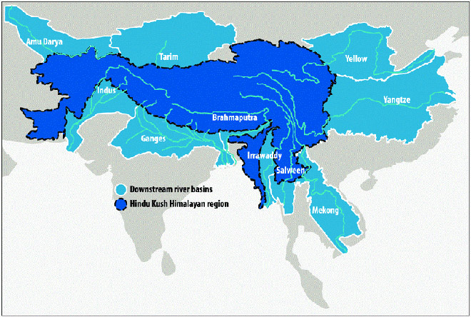
This brief examines the relationship between glaciers decline, and the changing surface water and groundwater regimes, in the Hindu Kush Himalayan (HKH) region[a] (See Map 1). This vast complex of high mountains produces one of the world’s largest renewable supplies of freshwater.[8] Indeed, the Himalayan region has the biggest reserves of water in the form of ice and snow outside the polar regions: it is the source of ten of the largest rivers in Asia, and is popularly called as the Third Pole.[9] These big river systems starting in the HKH region support irrigation in agricultural areas and provide drinking water to millions of rural and urban populations.[10]
Water flow within the Himalayas is a surface phenomenon that contributes to the recharge of groundwater in the region and downstream areas. Water that falls on the Himalayas is provisionally collected in various types of reservoirs[b] before being released into rivers. Of these, groundwater storage within catchments forms an essential element of the Himalayan water budget.[11]
Map 1: The Major river basins in the Hindu-Kush Himalayas
Studies conducted by the Indian Space Research Organization (ISRO) show that approximately 75 percent of the Himalayan glaciers are retreating at an alarming rate. These retreats will increase the variability of water flows to downstream areas and endanger the sustainability of water use in the earth’s most crowded basins.[13] Receding glaciers would also have an impact on the rates of groundwater recharge in some areas.
Springs are the main source of water for domestic and productive uses in the mid-hills. The declining glaciers have lesser impacts on the springs especially in the lower elevations as they are more dependent on the monsoon rains.[14] However, in the higher elevations, springs have direct connections with glaciers and their decline may affect the water flow.[15] Assuming that annual precipitation in the form of snow and freezing rain remains as it is, the loss of water stored as glacial ice will not likely change the quantity of meltwater that enhances water in the rivers and streams every summer. Groundwater resource is an essential part of HKH’s hydrology. However, it is also an uncertain resource though most of the areas in the hills are fed by groundwater systems for use in domestic uses and irrigation. Groundwater is decreasing in many locations in the HKH region where its overdraft is leading to a decline in the water supply through springs. In the central Ganges Basin, groundwater declines are due to the anticipated decline of glacial meltwater.[16]
This brief explains the interactions between surface and groundwater resources, with a focus on the HKH region. How are these two connected and what are the policy implications for their governance? Using existing literature, this brief examines the link between Himalayan glaciers, and surface water and groundwater regimes in HKH.
Himalayan Glaciers and Water Flow in the River Basins
The HKH region extends to about 3,500 km over eight countries—Afghanistan, Bhutan, Bangladesh, China, India, Myanmar, Nepal and Pakistan. It is the source of ten major Asian river systems, including the Indus, Ganges, and the Brahmaputra. Some 1.3 billion people directly depend on the HKH ecosystems, including for irrigation, power, and drinking water.[17] Figure 1 shows the importance of river basins in the HKH region as sources of water for the downstream regions. At present, the region is experiencing high levels of climate warming, and changes in precipitation patterns largely affecting its ecosystem.
The HKH region is home to some 54,252 glaciers, with a total area of 60,054 sq km and projected ice reserves of 6,127 km3. Data shows that only 1.4 percent of the HKH region is glaciated, with the total ice stocks roughly equal to three times the annual rainfall. However, there is a large disparity between river basins – the biggest total glacier areas are found, by size, in the Indus, Brahmaputra, and Ganges basins. The contribution of snow and glacier melt to runoff varies between these river basins.[19] For the upper Indus basin, glacier melt may contribute up to 41 percent of the total runoff; in the upper Ganga basin, it is 13 percent; and in the upper Brahmaputra, it is 16 percent. These rates are higher in the critical dry spring months, when other sources of runoff are scarce and, in the headwater, catchments indicating the significant role of seasonal melt runoff in the discharge.[20] Shifts in precipitation and runoff in the upstream glaciers sub-catchments during such critical moments are expected to strongly affect people’s livelihoods that are dependent on the river flows.[21]
Various studies show different results about the contribution of glacial decline on the river systems in the HKH region. For example, transient storage capacity in the region is about 28 km3 for the three main Nepal catchments; out of these, snow and glacier melt contributes around 14 km3 every year, which is about 10 percent of the annual river flow.[22] The individual figures on the contribution of glaciers to river flow vary based on the data and model used for assessment and projection, and the decline in glaciers will not have a direct impact on water flow in the rivers in HKH region except in Indus River where about 26 percent flow of a river is related with the glacier melt.
In the Nepal Himalayas, there is a lack of knowledge in understanding the high-altitude glaciers in the region.[23] This lack of knowledge leads to problems in knowing the water budget for its various watersheds within the larger context of retreating glaciers. The same studies found that the contribution of glacier annual meltwater to annual steam flow volume varies among catchment basins from two to 13 percent of the total annual flow from the basin, representing two to three percent of the total annual streamflow volume of the rivers of Nepal.[24]
Meanwhile, other studies have found that in the Himalayan region, between 2000 and 2008, there was a decreasing trend of the snow cover in January while there is a growing trend in March.[25] These same studies observe that the “elevation zones between 5,000 m to 7,000 m are likely to be most sensitive to climate change as most of the glaciers exist at these elevations and a significant amount of snow cover remains throughout the year. Therefore, a slight change in temperature at these elevation zones—particularly if it is around the threshold of freezing/melting point—could cause a significant change in the snowmelt.”[26] It is not only the snow-covered regions but also the snow depth and snow water equivalent will impact the snow melting, and this consequently influences the river flow systems and water resources availability that cause substantial changes in the river flows and water resources in spring systems.
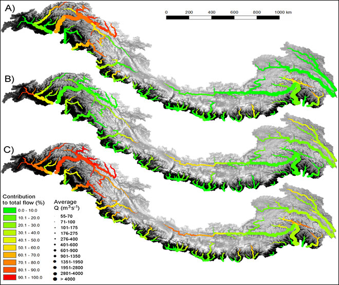
Figure 2: Contribution to total flow by flow components in major streams. a–c, Contribution to total flow by glacier melt (a), snowmelt (b) and rainfall (c) for major streams during the reference period (1998–2007).
The contribution of glacial melt to the water flow in the river is closely associated with the climate change process. Observations show indications of significant warming in the region, causing the Himalayan glaciers to retreat.[28] For example, the maximum temperature increased at the rate of 0.06 degree centigrade per year between 1978 to 1994 in the Nepal Himalayas. The warming rates are progressively higher for steeper elevations, resulting in the rapid shrinking of most glaciers in Nepal.[29]
Climate warming is affecting the hydrological regimes in the HKH regions, because of factors like changes in seasonal extremes, increased evapotranspiration, and changes in glacier volume.[30] These changes vary across the Indus, Ganges, and Brahmaputra river basins: in the Indus, the marked effect is on meltwater; for Ganges, the effect is on runoff that is expected to increase; and for the Brahmaputra, climate change may result in enhanced flood risk. However, the study forecasts that in all three basins, there would be a decrease in snow and a rise in glacier melt by the middle of the century. Initially, there will be an increased amount of meltwater available, but this quantity will decline abruptly as the glacier storage is reduced.
To be sure, the studies are still uncertain regarding these impacts and their exact timings, which will depend on the developmental pathways and mitigation efforts that are taken by policymakers. Other studies[31] also show a similar analysis. These studies on the Himalayan region suggest that overall runoff in the rivers will increase in the future due to a rapidly changing climate. This will happen because of the increase in rainfall and, in parallel, a decrease in net glacier melt. Current data shows that annual total water availability will change marginally until the middle of the century. However, an upsurge in extreme hydrological incidents associated with climate change— such as droughts and floods—might critically alter seasonal water availability in the downstream areas.
The Impact of Climate Change on Himalayan Surface and Groundwater Interaction
Most surface water in streams and rivers, except during and soon after precipitation events, is fed by the slow discharge of groundwater as it is “drained” from the groundwater system which is known as the base flow.[32] Groundwater reservoir therefore acts like a conveyor belt, moving groundwater to places where it traverses with the soil surface and becomes surface water. Hydraulic principles and the force of gravity determine which way the water will travel in all surface water and groundwater connections.[33] It is crucial to know and quantify the exchange methods between groundwater and surface water as it plays an important role in river basin management. The zone of movement, also known as the hyporheic zone, works critically in aiding groundwater and surface water contact.[34]
In the Himalayan region, the main source of recharge to groundwater is the glaciers, combined with surface runoff. In foothill areas, where precipitation is high, groundwater is abundant; however, due to sloppy and rocky surface, a larger percentage of the precipitation flows out. This results in less water getting infiltrated from subsurface to groundwater bodies. Groundwater comes out as seepage through springs under the favourable situation, forming the main source of water supplies to rural and urban hamlets in the entire Himalayan range. Springs also contribute supplementary water to the surface drainage network of the area.[35] Natural springs occur at the confluence of the sloping ground and impermeable strata with the groundwater table. The unconfined aquifers are largely the sources for the springs, where the water emerges under gravitational pull. The springs can be gauged by examining their temporal flow variation, determining what is popularly known as a spring hydrograph. Long-term monitoring of spring discharge can provide an understanding of seasonal variations and future projections if all other circumstances remain the same.[c],[36] Over the years, spring resources in the Himalayas have declined owing to increasing population and therefore demand, technologies that harness water, changes in rainfall patterns, and a poor legal policy framework for managing groundwater resources.[37] Groundwater storage in a fractured basement impacts the Himalayan river discharge cycle. This has added to the springs, which are the most important groundwater sources that connect the surface and groundwater systems in the mountains. Groundwater storage within catchments forms an essential element of the Himalayan water budget.[38]
These studies show that increased melting may increase the volume of water in rivers, which might lead to more extensive flooding. As glaciers retreat, the amount of meltwater flowing into rivers could decline considerably. Since surface and groundwater systems are interconnected, such a situation may lead to a substantial drop in the rates of groundwater recharge in some regions. This, combined with changes in summer monsoon rainfall and surface water flows, can cause huge water stress in many parts of the HKH region and affect the river basins that relate to the Himalayan glaciers.
Changing water regimes throughout HKH, coupled with high population growth, is creating the stress in groundwater reservoirs—this is manifested in the drying up of springs. However, there is lack of precise data on the interconnections and mapping of springs. The effects of groundwater-surface water interactions, land-use changes and vegetation-water interactions are some factors that need to be examined in a comprehensive manner.[39] The decline of springs has recently become a key source of concern given that a significant population in the mid-hills across the HKH region depends on springs for their daily water access. Tiwari and Joshi explain the case of the Koshi River Basin in Nepal and India where around 36 percent of groundwater springs have gone dry in a single catchment in the past 20 years.[40] Their study shows that around 61 percent of the villages have been encountering a huge shortage of water for drinking, sanitation and irrigation. Indeed, food production in various locations has declined by 25 percent,[41] as have the livelihood prospects in traditional forestry and agriculture.
A longitudinal study undertaken for 11 years in two watersheds in the mid-western Indian Himalayan hills in Uttarakhand collected data using automated rain gauges in select sites of the river basins.[42] They measured daily spring flow and all the springs used by residents. The data were collected in the range of two to 11 years, and the analysis shows that there is a high correlation between precipitation events and spring flows. In a comparable location of the western Himalayan region, another study observed that the spring flow during rainy and non-rainy seasons are affected by rainfall and recharge area types.[43]
In sum, the interaction of surface and groundwater is an important phenomenon in the Himalayan region that manifests itself in the form of springs, on which the communities depend for their agricultural, social, and economic activities. They are a unique feature in the region, where water emerges from an underground aquifer to the surface—this shows the interconnections of these systems. The underground aquifer systems are supported by the water regime in the upper reaches, which is fed by rainfall or glaciers, depending on the area.
Recent studies have shown that the springs are under increasing stress due to many factors including changing climatic conditions. As glaciers retreat, the rainfall patterns are altered as well—both these changes are directly influencing the spring system. As a result, many springs are declining, creating an impact on the hill populations who depend on them. The imperative is to protect the watershed and aquifer that feeds into the spring system, to improve surface and groundwater management in the HKH region.
Conclusion
There has been a recent increase in scholarly research seeking to make a connection between the decline of glaciers and climate change; these studies focus on surface water regimes. Another area of study is understanding how climate change influences groundwater systems—this present brief was an attempt to correlate glacier decline and water flows in the rivers feeding the groundwater and spring sources.
The literature reviewed in this brief showed that in lower altitudes, the decline in glacial mass balance is not going to affect the systems severely until the middle of the century. After 2050, however, the changes in climatic conditions will likely begin to affect the springs systems, reducing their recharge and flow. In the higher altitudes, these changes will emerge earlier, altering the water flow in rivers and springs. Groundwater is an essential part of the HKH region’s hydrology. The studies suggest that groundwater is already being reduced in many locations. The central Ganga basin, for example, is already seeing the overdraft of groundwater, which is influencing water supply downstream.
What are the implications on the governance of these resources? First, there is a lack of coherent perspectives and understanding of the interrelations of the surface and groundwater regimes in the HKH region, particularly the role of snow and glacier melt in groundwater recharge. There is also a lack of data-sharing and comprehensive approach to joint technical and scientific data management in the HKH region. To be sure, regional cooperation is critical for any coherent scientific data management and analysis for policymaking.
Second, there is a lack of understanding of the interrelations between surface and groundwater. While there is plenty of research on glaciers, the interactions between glacial declines on the water regimes—especially the groundwater recharge—remains an understudied subject. Third, a synchronised planning for the refurbishment of water in the region is absent. The HKH region is trans-boundary in nature, with watersheds spread across various countries. The trans-boundary administration of shared water has its challenges especially when countries that fall in the watershed do not have mutual confidence. This leads to ineffective water management at virtually every level in the HKH region.
A regional approach is necessary for the protection of the HKH’s interconnected systems. Countries that share the hydrological boundaries must come together to understand the nature of the resource, share data with one another, and contribute to comprehensive planning.
Author’s note
This brief was part of the author’s work under the project, Himalayan Adaptation, Water and Resilience (HIAWARE) consortium under ICIMOD and the Collaborative Adaptation Research Initiative in Africa and Asia (CARIAA) with financial support from the UK Government’s Department for International Development (DFID), London, UK, and the International Development Research Centre (IDRC), Ottawa, Canada. This work was also partially supported by core funds of ICIMOD contributed by the governments of Afghanistan, Australia, Austria, Bangladesh, Bhutan, China, India, Myanmar, Nepal, Norway, Pakistan, Sweden and Switzerland. The views expressed are those of the authors and do not represent those of the supporters. I would like to thank Arun Bhakta Shrestha, Santosh Nepal and Philippus Wester of ICIMOD for their valuable suggestions in the earlier draft of this paper. The time spent in revising this paper and its publication with ORF comes from Bharti Institute of Public Policy, Indian School of Business, India. The author wants to thank Aparna Roy of ORF and the two anonymous reviewers, for their valuable inputs.
About the Author
Dr Anjal Prakash is Research Director and Adjunct Associate Professor, Bharti Institute of Public Policy, Indian School of Business, Hyderabad, India. He was Coordinating Lead Author of IPCC’s Special Report on Oceans and Cryosphere, 2018, and for the ongoing 6th Assessment report of IPCC, he is lead author for the chapters on cities and mountains.
Endnotes
[a] ‘HKH region’ encompasses all the high mountain chains of Central, South and Inner Asia. These include the Tien Shan, Kun Lun, Pamir, Hindu Kush, Karakoram, Himalayas, and Hengduan and the high-altitude Tibetan Plateau.
[b] These reservoirs are soils, snow, glaciers, permafrost, and groundwater.
[c] Springs are places on the earth’s surface through which groundwater emerges and flows. They embody exfiltration of groundwater onto the surface. Springs in the Himalayan region add to base flows of streams and rivers. For centuries, spring water has been used by the people in the mountain regions of HKH in meeting basic needs for water.
[2] S. Cavazza and S. T. E. F. A. N. O. Pagliara, “Groundwater and surface water interactions,” Groundwater-Volume I (2009): 96.
[3] Cvazza et al., “Groundwater and surface water interactions”
[4] Thomas C. Winter, “Relation of streams, lakes, and wetlands to groundwater flow systems,” Hydrogeology Journal 7, no. 1 (1999): 28-45.
[5] Marios Sophocleous, “The evolution of groundwater management paradigms in Kansas and possible new steps towards water sustainability,” Journal of Hydrology 414 (2012): 550-559.
[6] Cvazza et al., “Groundwater and surface water interactions”
[7] Marios Sophocleous, “Interactions between groundwater and surface water: the state of the science,” Hydrogeology journal 10, no. 1 (2002): 52-67.
[8] Jayanta Bandyopadhyay and Dipak Gyawali, “Himalayan water resources: ecological and political aspects of management,” Mountain Research and Development (1994): 1-24.
[9] Günter Oskar Dyhrenfurth, To the Third Pole-The History of the High Himalaya(Nielsen Press, 2011); A Schild and R. A. Vaidya, “Water storage: A strategy for climate change adaptation in the Himalayas,” Sustainable Mountain DevelopmentNo. 56, special issue (2009).
[10] Harpinder Sandhu and Sukhbir Sandhu, “Linking ecosystem services with the constituents of human well-being for poverty alleviation in eastern Himalayas,” Ecological Economics 107 (2014): 65-75.; Golam Rasul, “Food, water, and energy security in South Asia: A nexus perspective from the Hindu Kush Himalayan region,” Environmental Science & Policy 39 (2014): 35-48; Golam Rasul and Bikash Sharma, “The nexus approach to water–energy–food security: an option for adaptation to climate change,” Climate Policy 16, no. 6 (2016): 682-702.
[11] Christoff Andermann, Laurent Longuevergne, Stéphane Bonnet, Alain Crave, Philippe Davy, and Richard Gloaguen, “Impact of transient groundwater storage on the discharge of Himalayan rivers,” Nature Geoscience 5, no. 2 (2012): 127-132.
[12] David Molden and Eklabya Sharma, “ICIMOD’s strategy for delivering high-quality research and achieving impact for sustainable mountain development,” Mountain Research and Development 33, no. 2 (2013): 179-183.
[13] A. K. Misra, “Global climatic variations and its impact on Indian hydrological conditions,” Int. J. Eng. Sci. Res. Technol 2, no. 2 (2013): 148-158.
[14] Tanzina Dilshad, Dwijen Mallick, Pranita B. Udas, Chanda G. Goodrich, Anjal Prakash, Ganesh Gorti, Suruchi Bhadwal et al., “Growing social vulnerability in the river basins: Evidence from the Hindu Kush Himalaya (HKH) Region,” Environmental Development 31 (2019): 19-33.; Vishal Singh and Anvita Pandey, “Urban water resilience in Hindu Kush Himalaya: issues, challenges and way forward,” Water Policy 22, no. S1 (2020): 33-45.
[15] Douglas James Merrey, Abid Hussain, Deepak Dorje Tamang, Bhuwan Thapa, and Anjal Prakash, “Evolving high altitude livelihoods and climate change: a study from Rasuwa District, Nepal,” Food Security 10, no. 4 (2018): 1055-1071.
[16] National Research Council, Himalayan glaciers: Climate change, water resources, and water security (National Academies Press, 2012).
[17] Philippus Wester, Arabinda Mishra, Aditi Mukherji, and Arun Bhakta Shrestha, The Hindu Kush Himalaya assessment: mountains, climate change, sustainability and people (Springer Nature, 2019); S.M. Wahid, A. B. Shrestha, M. S. R. Murthy, M. Matin, J. Zhang, and O. Siddiqui, “Regional water security in the Hindu Kush Himalayan region: Role of geospatial science and tools,” The International Archives of Photogrammetry, Remote Sensing and Spatial Information Sciences 40, no. 8 (2014): 1331.
[18] Richard G. Taylor, Bridget Scanlon, Petra Döll, Matt Rodell, Rens Van Beek, Yoshihide Wada, Laurent Longuevergne et al., “Ground water and climate change,” Nature climate change 3, no. 4 (2013): 322-329.
[19] Walter W. Immerzeel, Ludovicus PH Van Beek, and Marc FP Bierkens, “Climate change will affect the Asian water towers,” Science 328, no. 5984 (2010): 1382-1385.; A. F. Lutz, W. W. Immerzeel, A. B. Shrestha, and M. F. P. Bierkens, “Consistent increase in High Asia’s runoff due to increasing glacier melt and precipitation,” Nature Climate Change 4, no. 7 (2014): 587-592.
[20] Santosh Nepal, P. Krause, W‐A. Flügel, M. Fink, and C. Fischer, “Understanding the hydrological system dynamics of a glaciated alpine catchment in the Himalayan region using the J2000 hydrological model,” Hydrological Processes 28, no. 3 (2014): 1329-1344.
[21] Lutz, Consistent increase in High Asia’s runoff due to increasing glacier melt and precipitation.
[22] Andermann, Impact of transient groundwater storage on the discharge of Himalayan Rivers
[23] Donald Alford and Richard Armstrong, “The role of glaciers in stream flow from the Nepal Himalaya,” The Cryosphere Discussions 4, no. 2 (2010): 469-494.
[24] Alford, The role of glaciers in stream flow from the Nepal Himalaya
[25] Shreedhar Maskey, Stefan Uhlenbrook, and Sunal Ojha, “An analysis of snow cover changes in the Himalayan region using MODIS snow products and in-situ temperature data,” Climatic Change 108, no. 1-2 (2011): 391.
[26] Maskey, “An analysis of snow cover changes in the Himalayan region using MODIS snow products and in-situ temperature data,” pp. 398-398
[27] A. F. Lutz, W. W. Immerzeel, A. B. Shrestha, and M. F. P. Bierkens, “Consistent increase in High Asia’s runoff due to increasing glacier melt and precipitation,” Nature Climate Change 4, no. 7 (2014): 587-592.
[28] Walter W. Immerzeel, Philip DA Kraaijenbrink, J. M. Shea, Arun B. Shrestha, Francesca Pellicciotti, Marc FP Bierkens, and Steven M. de Jong, “High-resolution monitoring of Himalayan glacier dynamics using unmanned aerial vehicles,” Remote Sensing of Environment 150 (2014): 93-103.; A. F. Lutz, W. W. Immerzeel, A. B. Shrestha, and M. F. P. Bierkens, “Consistent increase in High Asia’s runoff due to increasing glacier melt and precipitation,” Nature Climate Change 4, no. 7 (2014): 587-592.
[29] Arun B. Shrestha and Raju Aryal, “Climate change in Nepal and its impact on Himalayan glaciers,” Regional Environmental Change 11, no. 1 (2011): 65-77.
[30] Santosh Nepal and Arun Bhakta Shrestha, “Impact of climate change on the hydrological regime of the Indus, Ganges and Brahmaputra river basins: a review of the literature,” International Journal of Water Resources Development 31, no. 2 (2015): 201-218.
[31] W. W. Immerzeel, F. Pellicciotti, and M. F. P. Bierkens, “Rising river flows throughout the twenty-first century in two Himalayan glacierized watersheds,” Nature geoscience 6, no. 9 (2013): 742-745.; Lutz, Consistent increase in High Asia’s runoff due to increasing glacier melt and precipitation; Nepal, “Understanding the hydrological system dynamics of a glaciated alpine catchment in the Himalayan region using the J2000 hydrological model.”
[32] D. C. Goodrich, Abdelghani Chehbouni, B. Goff, B. MacNish, Thomas Maddock, S. Moran, W. James Shuttleworth et al., “Preface paper to the Semi-Arid Land-Surface-Atmosphere (SALSA) program special issue,” Agricultural and Forest Meteorology 105, no. 1-3 (2000): 3-20.
[33] Goodrich, “Preface paper to the Semi-Arid Land-Surface-Atmosphere (SALSA) program special issue.”.
[34] E. Kalbus, F. Reinstorf, and M. Schirmer, “Measuring methods for groundwater? surface water interactions: a review.” (2006).
[35] S Gupta, “Ground Water Scenario of Himalayan Region, India,” Central Ground Water Board (2014).
[36] A. K. Vashisht and H. C. Sharma, “Study on hydrological behaviour of a natural spring,” Current Science (2007): 837-840.
[37] Kaustubh Mahamuni and Himanshu Kulkarni, “Groundwater resources and spring hydrogeology in South Sikkim, with special reference to climate change,” Climate change in Sikkim-Patterns, impacts and initiatives (2012): 261-274.
[38] Andermann, Impact of transient groundwater storage on the discharge of Himalayan Rivers
[39] Daniel Viviroli, David R. Archer, Wouter Buytaert, Hayley J. Fowler, G. B. Greenwood, Alain F. Hamlet, Yan Huang et al., “Climate change and mountain water resources: overview and recommendations for research, management and policy,” Hydrology and Earth System Sciences 15, no. 2 (2011): 471-504.
[40] Prakash Chandra Tiwari and Bhagwati Joshi, “Environmental changes and sustainable development of water resources in the Himalayan headwaters of India,” Water resources management 26, no. 4 (2012): 883-907.
[41] Tiwari, “Environmental changes and sustainable development of water resources in the Himalayan headwaters of India.”
[42] Avinash Agarwal, N. K. Bhatnaga, R. K. Nema, and Nitin K. Agrawal, “Rainfall dependence of springs in the Midwestern Himalayan hills of Uttarakhand,” Mountain Research and Development 32, no. 4 (2012): 446-455.
[43] G. C. S. Negi and Varun Joshi, “Geohydrology of springs in a mountain watershed: The need for problem solving research,” Current science. Bangalore 71, no. 10 (1996): 772-776.
The views expressed above belong to the author(s). ORF research and analyses now available on Telegram! Click here to access our curated content — blogs, longforms and interviews.

 PDF Download