India and Nepal’s Kalapani border dispute: An explainer
Neighbours India and Nepal, who share an open border, have not always had the most amicable of relations, oscillating from one extreme to the other. One of their long-standing disputes is over the border area of Kalapani. This discord has the potential to disrupt the other aspects of their ties, especially in the domains of the economy and cross-border security. Further, if the two countries fail to arrive at a resolution to the disagreement, it might give other stakeholders such as China an opportunity to interfere. This brief explains the Kalapani issue and in that context, explores what can be expected of the bilateral relationship in the future.
Attribution:
Sohini Nayak, “India and Nepal’s Kalapani Border Dispute: An Explainer,” ORF Issue Brief No. 356, April 2020, Observer Research Foundation.
Introduction
In November 2019, the Home Ministry of India released a new edition of the Indian political map, showing Jammu and Kashmir along with Ladakh as the new union territories of India.[1]This followed the events of August 2019, when the Indian government abrogated Articles 370 and 35A of the Indian Constitution which had given a special status to the State of Jammu and Kashmir; the government bifurcated the state, consequently requiring the immediate release of a new map.[2] The same map also showed the disputed ‘Kalapani’ region in the Greater Himalayas as within India’s borders.[3] The map portrayed the area as part of the Pithoragarh district in the state of Uttarakhand. Nepal immediately issued an objection to the map, as it identifies the region as an unsettled territory of the Darchula district in the country’s Sudurpashchim province.[4] In November 2019 the Ministry of External Affairs, Nepal, under the leadership of Foreign Minister Pradeep Kumar Gyawali also issued a statement for the media stating that, “The Nepal government is committed to protecting the country’s external borders and it is determined on its principled position that such border disputes with the neighboring countries should be resolved through diplomatic channels after assessing the historical documents, facts, and evidence.”[5]
In response, India has maintained that the map is “accurate”.[6] The new map—and the consequent objection from Nepal—brought forth the unresolved border disputes between the two countries. These disagreements involve not only Kalapani but also areas like Lipulekh, Limpiyadhura, and Susta.
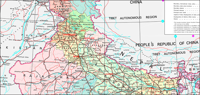
Map 1: Depicting the Pithoragarh disctrict and Kalapani border
This brief analyses the dispute over Kalapani and explores the reasons why India and Nepal have failed to arrive at a resolution since the Treaty of Peace and Friendship, concluded in 1950. It also outlines future scenarios in the India-Nepal border, and offers recommendations for both countries to avoid any escalation of conflict.
Indeed, the Kalapani area is of strategic significance in South Asian diplomacy as it serves as a tri-junction between India, China and Nepal. Given that Nepal is a “buffer state” between the other two countries—both with great-power aspirations in the region—the Kalapani dispute has important ramifications on the relations between the three.
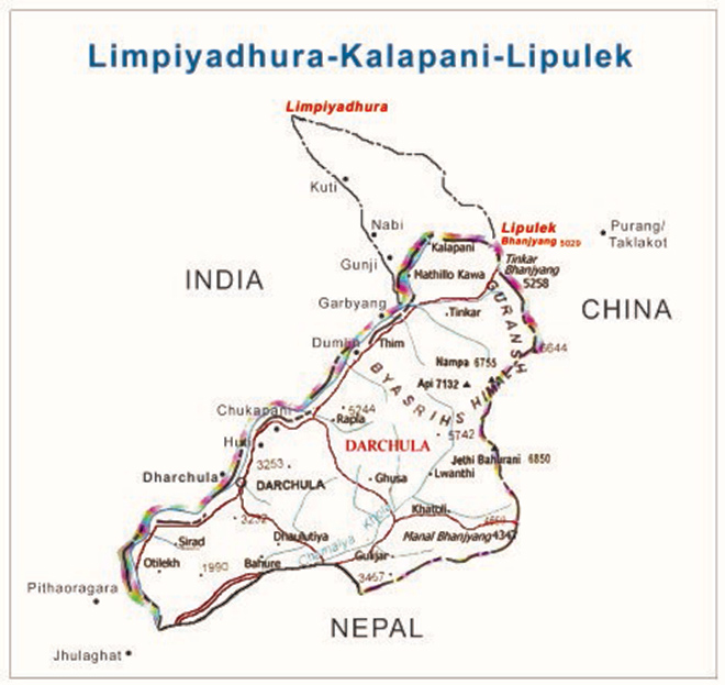
Key to the disagreement over Kalapani is the origin of River Kali. There are varied views regarding this river and its source. Buddhi Narayan Shrestha, former Director General of Nepal’s Land Survey department, had categorised the debaters into two broad groups. First, he said, are the scholars and researchers, along with the government machinery—to which he referred to as the “elite community” of Nepal. They are of the view that the river which flows to the west of Kalapani is the main River Kali, originating at either Limpiyadhura or the nearby Lipulekh pass, which are both within the Nepalese territory, thus justifying the area as an inherent part of Nepal. The second group comprises the Nepal-India Technical Level Joint Boundary Working Group, and officials of the Embassy of India in Nepal.[7] India, for its part, argues that the River Kali originated from a smaller rivulet named Pankhagad, lying on the southern portion of Kalapani and the subsequent ridge on the eastern part of this area is the true border, and therefore making the territory part of India.[8] Indeed, the River Kali has yet to be demarcated. Moreover, while it is known as ‘Kali’ at the upper reaches, the middle portion is called ‘Mahakali’ and the lower, ‘Sarjoo’ or ‘Gogra’; this aggravates the confusion about where it belongs.[9]
Most maps drawn by Nepal show the River Kali originating about 16 kilometers northwest of Kalapani at Limpiyadhura in the Zanskar range of the Himalayas. A map drawn in 1827 has been often regarded as “authentic”, as mentioned by Shrestha, as it carries the note, “Published According to Act of Parliament by James Horst Surgh, Hydrographer to the East India Company 1st Feb.1827.” Another map, first released in 1830 and updated in 1846, titled, “Western Provinces of Hindoostan”, demarcated the river[10] from Limpiyadhura.[a]. Most maps created during the periods 1846-1860 and 1860 -1880 have maintained the original geographical position of River Kali and Kalapani. The difference with the latter phase is the name of the river: Kali was then being called ‘Kuti’, and later, ‘Kuti Yangti’.
Nonetheless, most of these maps have been created by Nepal, and therefore viewed by India with skepticism. Maps after 1880 started mentioning a separate River Kali originating from the Lipulekh Pass, apart from the Kuti; Nepal lost some 310 square kilometers of land in the process, and it did indeed call out the “cartographic aggression”.[11]
The debates took life in the 1990s after Nepal restored its democracy. Much earlier, India had deployed security forces in this region during the Indo-China war of 1962. Kalapani was regarded as a ‘safe zone’ for Indian troops to be stationed, as its high altitude of 20, 276 feet was “effective defence against the Chinese.”.[12] At that time, too, China recognised Kalapani as India’s. Nepal, however, had conducted elections in the area in 1959 and collected land revenue from its residents, until 1961.[13]
Successive governments of India and Nepal have had repeated discussions on Kalapani. In the new millennium, the interaction between Prime Minister G.P Koirala of Nepal and India’s Prime Minister Atal Bihari Bajpayee is noteworthy. In July 2000, PM Koirala visited India and discussed cooperation with his counterpart. Both sides agreed to conduct field survey to affirm the demarcation of Kalapani, and set a target of completion for 2002. The then Joint Boundary Committee had also agreed to provide reports with newly created strip maps. Even as the External Affairs Ministry of India rejected proposals to withdraw the country’s troops from the region, a steadfast policy was undertaken to resolve the chapter. [14]
The Paradox of India and Nepal’s ‘Open Border’
India and Nepal have shared a multidimensional and cordial relationship over many decades. Since the launch of formal diplomatic relations between the two countries on 17 June 1947, India and Nepal have worked to maintain their mutual commitment to peaceful co-existence[15] as immediate neighbours. However, the 1880-kilometre border running along West Bengal, Uttar Pradesh, Bihar and Sikkim[16] has not been without disputes.
It was after the Peace and Friendship Treaty of 1950 was signed by India and Nepal that the two countries encouraged a well-identified and formally accepted “open border” between them. An “open border” means that there is free and unrestricted movement of people from either side. Despite the presence of border checkposts and the deployment of border security forces, movement across the physical demarcation is relatively easy, leading to better social and trade connectivity between the two countries.[17] For both India and Nepal, this open nature of the border has often been described as a “springboard of opportunities” with natural common interests.[18] For Nepal, this meant enhanced movement of goods from India, which is a major transit hub for the small landlocked country.[19] At the same time, the country is able to avail of better opportunities in sectors like health and education along with the labour market with hundreds of Nepalese migrating to India for prospective jobs, thereby remitting huge amounts from India. [20] Likewise, India has also been benefiting from investments in Nepal in sectors such as roadways and other infrastructure projects, hydropower projects, tourism and agriculture through the Bilateral Investment Promotion and Protection Agreement (BIPPA), signed in 2011. India also endorses and benefits from the important cross-border projects like Jalpaiguri–Kakarbhitta, Jogbani– Biratnagar, Jaynagar–Bardibas, Nautanwa–Bhairahawa and Nepalgunj Road– Nepalgunj rail links and commitment to cross-border construction of oil pipeline between Raxaul and Amlekgunj, between the Indian Oil Corporation and the Nepal Oil Corporation, to mention only two. [21]
Historically, India and Nepal were both parts of the colonised sectors of the British East India Company. The Anglo-Nepal war of 1814 and the subsequent treaty of peace signed in 1816 resulted in the delimitation and the delineation of the border between the two countries. While the Mahakali River formed the western boundary, the Mechi River boundary was formed along the east with ridges in the Darjeeling hills and Sikkim.[22] With this, more than 900 pillars made of stone were erected along the India-Nepal border for better connectivity.[23]Analysts have observed that the British had chosen to demarcate their border using these ad-hoc and unstructured pillars for a number of reasons: Nepali soldiers from the hilly terrains could easily be recruited for the British Army; markets in Nepal territory could be properly utilised for British-made goods; and raw materials from Nepal like timber and firewood could easily be transported to India. [24]
Around a century later, this “open border” between India and Nepal still remains. There are analysts who say that this “open border” makes the relationship of the two countries “special”.[25] At the same time, other analysts are referring to what they call a “liberal paradox” in relation to “open borders”. On the one hand, liberal theorists like Joseph Carens have argued, open borders bring about a utilitarian environment, conducive to people living on both sides of the demarcation.[26]There would be free mobility and proper implementation of the readily available resources or raw materials in the area, benefitting especially those in close proximity. On the other hand, the determination of the extent of such “openness” is a question that creates a dilemma: that an “open border” would bring about threats to established “liberal territorial polities and communities” from non-state entities; these threats include terrorism, smuggling or trafficking.[27]
In the case of Nepal, the open border acts as a “safety valve” for the country vis-a-vis income generation and employment promotion from its bigger neighbour, India. At the same time, however, the open border system is criticised for allowing issues like a wider circulation of fake currency, and the under-documentation of informal trade (around one –third that go through the non-custom checkpoints).[28]
Another issue is that while this specific Indo-Nepal border does not require the use of a passport or a visa except for air travel, there are areas that have been declared as “restricted” to non-Indians, including Nepali citizens. A parallel in India’s case is in the northeastern states like Manipur, Arunachal Pradesh and Nagaland, where special permission is required for both the Indians as well as outsiders.[29] This prevailing circumstance is undeterred by the presence of the border security force (BSF), Special Security Force (SSF) and the integrated checkposts. In this regard, as has been surveyed over the years, the lackadaisical attitude of the security forces may be detrimental in resolving the existing disputes in the long run if they do not adhere to more stringent measures for people crossing over without proper documentation. [30]
The “open border” system in this perspective of the two neighbours has its roots before 1950.[31] The most recent assumption that may be forwarded is the establishment of four important districts of Nepal—Banke, Bardiya, Kailali and Kanchanpur—as the ‘New Territory’ or the ‘Naya Muluk’ from the then British India in 1860.[32] On the Indian side, the border was with Sanauli, Gorakhpur, Lucknow and Rupidiha. It is from this point onwards that the official identification of the open border took place between the two neighbours. The reinforcement of this aspect was again found in the Peace and Friendship Treaty (31st July 1950). Article VII of the Treaty mentioned the movement of the people from either side on a ‘reciprocal basis’.[33]
Problems arose in 1989 when India unilaterally closed 22 border crossing points and 15 transit points for Nepal. This border blockade was a blow to what was then a nascent Indo-Nepal bilateral relationship. Eventually, two points in the border were opened up: the Jogbani-Biratnagar and Raxaul-Birganj.[34] In 2015 a second blockade took place between the two countries, often referred to as a humanitarian and economic crisis for the Himalayan neighbour. The situation was responsible for further disrupting the border-centric relationship because it took place right after the small country was hit by a devastating earthquake. Moreover, the event had also come across at a point when the Indian Prime Minister Narendra Modi had been emphasising on India’s stance towards the ‘Neighbourhood First’ policy.
Challenges in Border Administration
Both India and Nepal have done little to resolve the bottlenecks along their borders, including in the Kalapani region which is the subject of this brief. The Kalapani border has yet to be properly demarcated, especially the so-called ‘no-man’s land’ in the area.[b]
For example, it was only in November 2019 that a joint team of security personnel from the Armed Police Force (APF) of Nepal and the Indian Sashastra Seema Bal (SSB) commenced a campaign for clearance with regard to the ‘no-man’s land’ in the border near Sunsari and Morang on the Indian and Nepali sides, respectively. Following this, those who were found to have been encroaching the area—between border pillar number 185/PP74 (main) to border pillar number 184 (main)—were evicted. Of these border pillars, 23 were found to be missing in the Sunsari district. [35] The main aim was to make the space well-defined so that there are no future troubles for the people who live in those areas and have the liberty to cross over the open system at any time.
The Nepal-India Joint Border Inspection Mechanism of 1981 and the Nepal-India Joint Border Management Committee, formed in 1997,[36] are both noteworthy in the discussion about efforts that have been made by both countries in the past. Additionally, in order to make agreements and bilateral talks on border clearer, the Nepal-India Joint Technical Level Boundary Committee (JTBC) was constituted in 1981 (dissolved in 2008).[37] These organisations mainly worked to bring about a comprehensive border management system along with the re-establishment of the boundary pillars from the British era and the periodic inspection of keeping the boundary intact. Boundary base maps and strip maps of 1:15000 scale covering 50 meters from either side were also created with the construction of boundary pillars—which are basically subsidiary or additional pillars in the specific riverine segments.[38] Despite such efforts to create a rules-based order, several segments have remained prone to disputes.
The Joint Technical committee worked for around 26 years and completed 97 percent of the boundary problems which may be categorised as relatively minor in nature. The remaining three percent was claimed to be beyond their capacity to resolve. This area includes the Kalapani-Limpiyadhura—the largest encroachment of 370 square kilometers, Susta of 24 kilometers and various other spots occupying around 15 kilometers. There are around 71 spots covering a total of 606 square kilometers.[39] One of the most important reasons behind the continuation of such a status is the unavailability of old maps and documents for demarcation. There are also ‘cross-occupations’ that require major identification here. A fitting comment is one by Bernardo Michael in The Natural environments and the Shifting Borders of Nepal by Buddhi Narayan Shrestha: “Even today, the presence of boundary disputes between India and Nepal, clearly show that this project of drawing modern boundaries will always be an unfinished one, because human actions can never be fully constrained by lines drawn on a map.”[40]
One of the most vital reasons of insecurity for India is the presence of China, which shares 1,439 kilometers of border with Nepal. Nepal and China had also signed a boundary agreement after much dispute on 21 March 1960. There were problems regarding the Mount Everest, to mention one, which was finally and formally settled when the then visiting Chinese Prime Minister Chou En-Lai declared in 1960 that “Mount Everest belongs to Nepal.” From here, the border-related issues between the northern neighbour and Nepal have been more stable and peaceful, giving them the opportunity to nurture relations in other integral issues like trade and connectivity.[41] Moreover, Nepal is also an integral part of the Belt and Road Initiative (BRI) of China. However, it must not be forgotten that South Asian diplomacy is far more complex than it usually appears to be. One of the main cushions that India has guaranteed for itself, in this situation, is the controversial Lipulekh Agreement signed on 15 May 2015 between Prime Minister Narendra Modi and Chinese President XI Jinping. As specified, the Lipulekh corridor can be used by India as and when required. “Point 28, in 41 points joint statement, clearly violates Nepal’s sovereignty as it was signed without Nepal’s involvement. That was not only the first time, the two countries have been mentioning Lipulekh, the tri-junction between Nepal, India and China, in their bilateral statement since 1953, neither India nor China, consulted Nepal before agreeing to open the route through Lipulekh”. [42]
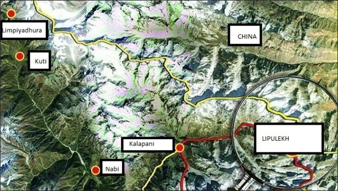
Map 3: Depicting Limpiyadhura, Kalapani and Lipulekh
The Lipulekh Pass is the most flexible and shortest route to reach Taklakot, a Tibetan township of China (as shown in Map 2). It is here that there is the presence of a strategically important hill with 6,180 meters height on the south of Kalapani[43] (as shown in Map 3). India’s access to this corridor will not only make it economically sound with trading windows with Tibet, but would also facilitate its security and observation of the ‘Kalapani’. Nepal is not unaware of this situation and has since been calculating its diplomatic steps vis-à-vis both the regional superpowers.
Conclusion
India and Nepal must chalk out their borders in a formal and friendly manner, to avoid other disputes such as the one over the Kalapani area. India should also move beyond its insecurities related to China. Although the Nepali Parliament has taken up the issue seriously, the two governments should fill the communication gap as a matter of urgency.
Both India and Nepal must invest in negotiating new border management agreements to take into consideration recent events. After all, the demands of the times have changed since the time the Kalapani border dispute first emerged. In the process, the people of both countries should be prioritised.
Endnotes
[a] This map was published by Parbury Allen & Co in London and was captioned “constructed from the most recent surveys”
[b] The no-man’s land is a particular area between two countries, which remains uninhabited. Nepal and India also has this space, 16 meters south of the Nepal-India border pillar number 61/647, where India has allegedly built a bridge and pitch road on its side.
[7] Buddhi Narayan Shrestha, ‘Border Management of Nepal’, 2003, Bhumichitra Co. P. Ltd, Kathmandu, Nepal, p. 126
Toya Nath Baral, ‘Border Disputes and Its Impact on Bilateral Relation: A Case of Nepal India International Border Management’, file:///E:/S%20Nayak/Downloads/26710-Article%20Text-79858-1-10-20191214%20(1).pdf p.32
[18] Rajeev Kumar, ‘India-Nepal border: Springboard for Opportunities’, International Studies, No. 50 (1 & 2), Jawaharlal Nehru University, Sage Publications, 2016, p. 167
[19]Andrea Blair Hernandez Forester, “Non state Actors And The Open Border Policy: The Border Security Case Study of Nepal And India”, p. 12, Naval Postgraduate School, Monterey, California, December 2014
[20] Sohini Nayak, ‘Covid -19 and migrant labour’, South Asia Weekly, Observer Research Foundation, New Delhi, India, 14 April 2020.
[26] Joseph H. Carens, ‘Aliens and Citizens: The Case for Open Borders’, The Review of Politics, Vol 49, No. 2, Spring 1987, Cambridge University Press, for the University of Notre Dame du lac on behalf of Review of Politica, pp. 251-273.
[37] Toya Nath Baral, ‘Border Disputes and Its Impact on Bilateral Relation: A Case of Nepal India International Border Management’, file:///E:/S%20Nayak/Downloads/26710-Article%20Text-79858-1-10-20191214%20(1).pdf
[42] Bhim Nath Baral, ‘Nepal-China –India: Prospects and Challenges of Trilateralism’, Research Article, Department of Political Science, Tribhuvan University, Pokhara, Nepal, p. 16, file:///E:/S%20Nayak/Downloads/bhim%20nath%20baral%20(1).pdf
The views expressed above belong to the author(s). ORF research and analyses now available on Telegram! Click here to access our curated content — blogs, longforms and interviews.
Sohini Nayak was a Junior Fellow at Observer Research Foundation. Presently she is working on Nepal-India and Bhutan-India bilateral relations along with sub regionalism and ...

 PDF Download