Abstract
The Sundarban ecoregion, straddling India and Bangladesh, is home to the largest contiguous mangrove forest in the world. Parts of the forest are designated as World Heritage Sites in both countries due to their rich biodiversity. The natural areas of the Sundarban are influenced by human use and, in recent years, increasingly by climate change. This paper explores an institutional arrangement that could help identify and implement the options that India and Bangladesh should exercise in dealing with the heightened challenges in the Sundarban landscape. The areas of cooperation for ecoregional environmental security should include freshwater and sediment management; ecosystem management to address degradation; food security through agriculture and fishery; human development; and climate action.
I. Introduction
The Sundarban ecoregion—located in the tidally active lower deltaic plain of the Ganges-Brahmaputra-Meghna basin—hosts the largest contiguous mangrove forest and the only mangrove tiger habitat in the world. Spread over parts of Bangladesh and India, the Protected Areas within the forested part are designated by the UNESCO as World Heritage Sites in both countries. The natural areas spanning 10,247 sq km across the two countries are also Ramsar Sites, or Wetland of International Importance. The mangrove forest “acts as a vital protective barrier protecting the mainland from flooding, tidal waves and cyclones.”[1]
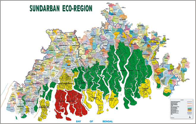
Map 1. The Sundarban Ecoregion
The natural area was at least twice as large in the 1830s when Dampier and Hodges surveyed the extent of standing forest. Beginning in the 1770s, the British East India Company and, subsequently, the British Government of India encouraged cultivation and settlement in the ecoregion with the view of augmenting revenue. The cleared tracts are now home to over 7.2 million people. The forest boundary has not undergone any significant changes since 1947. The natural areas, barring those falling under the ‘Protected Areas’ category, are greatly influenced by direct human use. For a better understanding of the relationship between human settlements and the ecosystems – the interactions within a complex social-ecological system – India and Bangladesh intend to map and delineate the human settlements on their respective sides that directly depend on ecosystem resources and which influence the ecosystem.[2] This understanding is meant to inform the development of a management plan for sustainable exploitation of resources for development and poverty alleviation.
The term ‘Sundarban’ is understood differently in the two countries. In Bangladesh, Sundarban refers to the natural area, essentially the Ramsar Site No. 560 spanning 6017 sq km. In India, meanwhile, the term means the Sundarban Biosphere Reserve (SBR), encompassing tracts of about 5,400 sq km settled at different times since the 1770s and the Ramsar Site No. 2370 spanning 4,230 sq km.
This paper explores the areas of cooperation between India and Bangladesh to build environmental security in the Sundarban. The rest of the paper is structured as follows: The next section outlines the state of existing cooperation on the region. The subsequent section suggests ways of defining the Sundarban Landscape for the purpose of implementing the MoU. The paper then describes the impacts of climate change on the region and the people’s dominant livelihoods, outlines the challenges in India-Bangladesh cooperation on Sundarban, and explores the possible institutional arrangement between the two countries, moving forward.
II. Cooperation on Sundarban: An Overview
In 2011 the governments of India and Bangladesh signed a Memorandum of Understanding (MoU) on ‘Conservation of the Sundarban’. The MoU was entrusted to the respective ministries of Environment, Forest and Climate Change in the two countries. A Joint Working Group (JWG) was created to oversee the implementation of the MoU (See Table 1).
Table 1: Actions listed in the 2011 MoU
| |
Items of work envisioned in the MoU |
Status |
| 1 |
Establish a Joint Working Group (JWG) to define activities, responsibilities, time, and resources involved, according to the activities established as per the MoU (Article VI) |
As of date the JWG has met only once, on 21 July 2016 in New Delhi. |
| 2 |
Map and delineate human settlements dependent on ecosystem resources (Article III) |
In Bangladesh, the Sundarban Landscape comprises the Sundarban Reserve Forest and the adjoining Ecologically Critical Area. In India, the Sundarban Biosphere Reserve is considered as the landscape. |
| 3 |
Undertake joint monitoring of resources (Article II) |
Monitoring is non-systematic and sporadic, and mostly academic rather than management exercises except for monitoring tiger numbers. |
| 4 |
Undertake joint management of resources (Article II) |
Forest management regimes are different on the two sides. About 54% of the forest on the Indian side is under Protected Area management, while the corresponding figure for Bangladesh is 23%, whereas population pressure on the Indian side is twice as much. The respective parts of the ecoregion are also not managed as an ecological unit. Civil administration manages the inhabited part while the forested areas are under the jurisdiction of the Forest Directorate. In short, a case of fragmented management. |
| 5 |
Undertake conservation and protection (Article II) |
It appears that the basic assumption on both sides is that protection amounts to conservation. Current efforts are limited to protection of designated species and spaces. There is, as yet, no effective conservation measure that restores habitats on a systematic and scientific basis targeting any particular species or space. |
| 6 |
Undertake habitat restoration and rehabilitation (Article II) |
| 7 |
Undertake mangrove regeneration (Article II) |
Attempts at mangrove regeneration are opportunistic and rather small. These attempts do not take into account loss of mangroves due to current and anticipated impacts of climate change, sea level rise and rapid erosion in particular. |
| 8 |
Facilitate ecoturism (Article II) |
A Standard Operating Procedure (SOP) was signed on 25 October 2018 for movement of passenger and cruise services along with an addendum to ‘Protocol on Inland Water Transit and Trade’ (PIWTT) for inclusion of new Ports of Call to facilitate easier movement of goods and passengers. |
| 9 |
Develop management plans (Article III) for:
(a) Livelihood improvement
(b) Disaster management
(c) Mitigating man-animal conflict
(d) Pollution control and management
|
Local level management plans exist but none of these are transformational and do not take into account current and anticipated impacts of climate change. Disaster management plans do not encompass recovery. |
| 10 |
Catalogue flora and fauna and identify threats of endangerment and extinction (Article IV) |
Flora and fauna are well-catalogued. |
| 11 |
Develop endangerment and extinction threat mitigation plan (Article IV) |
Threat mitigation plans are non-existent. |
| 12 |
Undertake research to develop a common and shared understanding of impacts of climate change (Article V) |
Knowledge on impacts of climate change exists in the two countries but these are mostly site-specific. |
| 13 |
Develop implementable adaptation strategies (Article V) |
Small-scale projects have been undertaken more with a no-regret approach than as adaptation. |
| 14 |
Joint research and management projects (Article VI) |
A few externally funded joint research projects have been carried out by university faculty. |
| 15 |
Share knowledge on and for biodiversity conservation (Article VI) |
Knowledge exists on biodiversity components, more in the form of inventories. There is limited understanding on structure and function of these components in the ecosystem. |
| 16 |
Joint tiger estimation (Article VI) |
Tiger estimation is periodically undertaken in both countries. The last such exercise was simultaneous. |
| 17 |
Border patrol to prevent poaching and wildlife trade (Article VI) |
Ongoing |
| 18 |
Capacity building of filed level Forest Officials (Article VI) for:
(a) Biodiversity conservation
(b) Climate change adaptation
(c) Sustainable socio-economic development
(d) Ecotourism
|
There is hardly any capacity at the field level on any of the listed items. There has not been any joint training on any of the items. |
| 19 |
Training at WII of Forest Officials from Bangladesh (Article VI) |
Officials from Bangladesh have attended courses at WII in the past but sporadically. |
As Table 1 shows, more than seven years since the MoU was signed by India and Bangladesh, the two sides have little to show in terms of achievement. Indeed, it took almost five years for the first meeting of the JWG to be convened in July 2016 in New Delhi. Much of the mandate of the MoU cannot be undertaken in the absence of a robust cooperation mechanism that is adaptive, encourages open information exchange and multi-stakeholder participation (particularly among those who are most affected by the decisions), and facilitates institutional coordination. The second JWG meeting is likely to be convened in the first quarter of 2020.
India and Bangladesh have gone past the pre-initial phase of cooperation and the mode of implementation is unlikely to be unilateral action. This has been articulated in Article VII of the MoU thus: “Should changes of national policies in either country result in difficulties in the further development and implementation of this Memorandum, both countries will do their utmost to ensure a reconciliation vis-à-vis the difficulties raised.” While the need is to progress to the so-called ‘advance phase’ of cooperation—characterised by joint action—little can be achieved until, first, a universal definition of what constitutes the Sundarban Landscape is agreed upon.
Delineating the Sundarban Landscape
For the purpose of implementing the MoU of 2011, there could be various ways of defining the Sundarban Landscape. Bangladesh uses the concept of Ecologically Critical Area (ECA) to delineate the human inhabited area adjoining the Sundarban forest within its territory. ECA was declared in 1999 under the Environment Conservation Act of 1995. The ECA is a 10-km-wide buffer zone along the northern and eastern boundaries of the Sundarban Reserve Forest (SRF). Therefore, for Bangladesh, the SRF and the adjoining ECA constitutes the Sundarban Landscape. A similar distance band could be delineated on the Indian side for purposes of implementing the MoU. (See the hatch lines in Map 1.)
In Bangladesh, a total of 45 Unions (analogous to gram panchayats in India) in 10 upazilas (subdistricts) of five districts are within the ECA, covering an area of about 1,750 sq km with a population of 1,035,540 as per the Census of 2011. Only the rural populations have been taken into account, given that they are more directly dependent on ecosystem resources; moreover, there is not a single urban area on the Indian side. Since the ECA is a distance band from the edge of the forest and does not take into account administrative boundaries, in the map it has been either extended or reduced to coincide with the nearest Union boundary, to arrive at population figures. Applying a similar 10-km-wide buffer zone along the Sundarban Tiger Reserve and Reserve Forest of South 24-Parganas Forest Division in India, a population of 547,011 in 25 gram panchayats in six blocks (subdistricts) of two 24-parganas districts could be considered to be part of the transboundary Sundarban Landscape. Taken together, according to this definition, the landscape, as per Census of 2011 has a population of 1,582,551 in 70 unions/gram panchayats in 16 upazilas/blocks of seven districts. Along with the natural area, this could constitute the Sundarban Landscape for the purposes of nurturing cooperation between Bangladesh and India on the conservation of the ecoregion.
Another option to define the region could be based on the presence of natural tidal creeks. In this case, the landscape would encompass 313 unions/gram panchayats in 41 upazilas/blocks of seven districts with a population of about 7.2 million; the entire area shown in Map 1 barring 41 gram panchayats out of the 190 that currently constitute the Sundarban Biosphere Reserve on the Indian side. The 41 gram panchayats along the western periphery—from Canning-I block to Mathurapur-I block—would have to be left out due to the absence of tidal creeks. In this case, the Sundarban ecoregion and the Sundarban Landscape would be co-terminous.
Yet another definition of the landscape could be based on the Dampier-Hodges Line, the extent of forest in 1829-1830 when surveys were carried out from Kulpi along River Hugli to Rabnabad Islands on River Meghna. (The Dampier-Hodges Line is depicted in Map 1 by the dark blue broken line.) In this case, the rural population would be about 1.67 million. The intention to define the Sundarban landscape (Article III) is yet to see any movement, however.
III. Impact of Climate Change on the Sundarban Region
Two adjoining grids of one-degree latitude by one-degree longitude (each approximately 100 km-wide) representing the Sundarban region are projected to warm by between 1°C-3.7°C by the year 2100, relative to a 1951-1980 baseline period, under the four Representative Concentration Pathway (RCP) scenarios.[3] The current policy and pledge trajectories appear to be well above emissions pathways consistent with the long-term temperature goal set by the Paris Agreement. The Intergovernmental Panel on Climate Change (IPCC) in its Fifth Assessment Report (AR5) has marked out lower Bengal Delta for high risk of coastal flooding and wetland loss in the 21st century.[4] The anticipated extent of coastal flooding on account of sea level rise at the end of this century (based on projected temperature rise) can be visualised using the tool called ‘Surging Seas’, or global interactive maps that show the risks posed by sea level rise to coastal communities.[5]
Cyclonic activity
Among the natural hazards that occur in the subcontinent, cyclones are the most severe and most frequent in the Sundarban region. Out of 14 global tropical cyclones associated with the highest fatalities in recorded history, nine have occurred in the Bay of Bengal.[6] Projections show that globally, the frequency of tropical cyclones is likely to remain unchanged, with rains getting more extreme near the centres of the storms.[7] Global warming, however, will intensify cyclone activity and heighten storm surges.[8] Intensified cyclonic activity will increase the depth of inundation and may penetrate further inland, threatening larger areas and increasing the destructive impacts of cyclones.[9] Moreover, due to the semi-enclosed nature of the Bay of Bengal, storms that form in this region are quite likely to strike land. Thus, the global-warming-induced intensification of the storms, coupled with the probability of cyclone landfalls, is likely to increase with consequent damages in the Sundarban even if their global frequency remains unchanged.
Sea-Level Rise
For the Sundarban coast, the maximum centennial-scale Relative Sea Level Rise (RSLR) is estimated to be 0.9 ± 3.3 cm/yr based on subsidence rates obtained through the dating of buried salt kiln sand mangrove root horizons.[10] Future rates of sea level rise are expected to exceed those of recent decades,[11] increasing the incidence and severity of coastal flooding, erosion, and saltwater intrusion into surface and groundwater.[12] Beaches may erode, and mangroves and salt marshes could decline, unless they receive sufficient fresh sediment to keep pace or they can move inland,[13] [14] [15] or estuary management involving managed retreat is resorted to.[16] Increased sea level could cause increased backwater effect in the coastal rivers and push the saline front further inland. More importantly, the saline front will move inland at an earlier time and remain for a longer duration due to the backwater effect from sea level rise. Additionally, backwater effect will impede drainage, resulting in a relatively prolonged inundation of the forest land. Prolonged flooding episodes could however increase the rate of sedimentation/siltation in the back swamps and creeks inside the forest area. Such a change could, to an extent, offset the permanent inundation of the forest floor due to continued increase in sea level. Flooding from storm surges remains a significant hazard even when embankments are present, as these events are capable of wiping out embankments. Given the relatively flat landscape, hazard mapping suggests that a 45-cm rise in sea level may destroy 75 percent of the Sundarban.[17]
Erosion
There is no dearth of evidence that mangroves play a crucial role in protecting coasts against natural hazards such as storms, tsunamis and coastal erosion. However, a combination of sea level rise and tidal hydraulics often results in erosion of the sea face and estuary margins. This in turn causes progressive reduction of land area in the islands and also the raising of channel floors, leading to prolonged inundation. Consequently, the entire southern face of the region has retreated, irrespective of whether the islands are forested or inhabited. The rate of erosion is highest in the west-central section between the Saptamukhi and the Gosaba estuaries, reaching up to 40 m/year.[18] In the Indian part of the Sundarban, the total erosion over the preceding 30 years is estimated to be 162.879 sq km.[19] Similar studies in Bangladesh show that the average rates of erosion for the eastern and western parts of the Sundarban Impact Zone (SIZ, a 20-km-wide band from the edge of the forest[a]) are 14 m/year and 15 m/year.[20] The studies reveal that during the period 1973-2010, loss of land due to erosion was 233 sq km.
Consequences to Agriculture
Agricultural production is under constant threat from natural hazards like storm surge, salinity incursion, water logging/drainage congestion, tidal flooding, and river erosion. Based on the IPCC projections of sea level rise in Bangladesh, it is estimated that the suitable area for transplanted Aman paddy will be reduced to 60 percent by 2050 with a sea level rise of 32 cm, and by the year 2100 only 12 percent suitable area will be available with a sea level rise of 88 cm.[21] [22] The prospects of farming on the Indian side are also poor due to recurrent brackish water inundation and low irrigation intensity ranging between 2.36 percent and 19.05 percent. None of the subdistricts within ECA can support the population through agriculture. Agriculture is at best an important occupation but not the driver of the economy. Indeed, activities related to cultivation and livestock rearing among agricultural households in India contribute only about 43 percent of average monthly household incomes.[23] The share of cultivation and livestock rearing in average monthly household incomes of agricultural households in SBR is possibly lower than the all-India figure because average cropping intensity in the Sundarban subdistricts is about 120 percent compared to the national average of 136 percent. In Bangladesh, cropping intensity within a 20-km distance band from the edge of the forest is 149 percent. Therefore, neither now nor in the future would it be possible for agriculture as we know it, to sustain the population in the Sundarban.
Households on the front lines of climate change impacts are already “hollowing out” as economic necessity drives working adults to seek outside earnings.[24] A DECCMA study in the Indian Bengal Delta found that 18 percent of the surveyed households (n=1315) had migrants of which three percent cited environmental stress (event) as the direct cause of migration. The study further found that 23 percent of the current non-migrant households intend to migrate in the future due to multiple impoverishment risks.[25]
It is clear that climate change and accelerated sea level rise due to global warming will have a potentially devastating effect on the Sundarban region and its inhabitants. However, in both India and Bangladesh, the issue of coastal erosion and inundation in the Sundarban is missing in planning and management.
IV. Key Challenges in India-Bangladesh Cooperation in Sundarban
The MoU signed in 2011 by India and Bangladesh fails to take into account the issues of effective sea level rise, coastal flooding, loss of land and intensifying cyclonic storms other than mentioning the need to undertake research to develop a common and shared understanding of impacts of climate change, and capacity building of field level Forest Officials for climate change adaptation. Even if the Items of Work were to be pursued vigorously, it is unlikely to (i) mitigate coastal flooding on account of sea level rise, (ii) halt or reverse erosion, (iii) ensure fresh sediment supply to keep pace with sea level rise or undertake elevation recovery, (iv) make good the damages inflicted by cyclone landfalls, or even (v) facilitate inland movement of mangroves. This is because much of the work is outside the purview of the Forest Department in the respective countries, and the scale of the interventions might be such that these cannot be undertaken without external assistance both in terms of technology and finance. Adaptation to climate change in the region would require (i) large-scale estuary management through construction of embankments and dykes, and even retreat from certain locations (similar to and possibly bigger in scale than that in the Netherlands); (ii) elevation recovery to deal with effective sea level rise; and (iii) saltwater agriculture and aquaculture, and freshwater supply through desalinisation of subsurface brackish water, necessitating access to climate finance and other innovative financial instruments. These are unlikely unless there is a cooperation mechanism that involves all the relevant stakeholders within each country, and facilitates collaboration between the two.
The JGW has met only once since the signing of the MoU in 2011 while thousands of hectares of land have been lost resulting not only in physical and occupational displacement of people, but also reducing the terrestrial component of the landscape that sustains the human population and the iconic Bengal Tiger. At this rate of bilateral consultation, it is unlikely that responses to long-term, large-scale challenges in the form of joint action can be formulated and implemented that are commensurate with the rate of environmental change. This drift must be arrested while at the same time future planning for the region must acknowledge the transformations underway. Future planning for the Sundarban under an assumed static climate regime as is apparent from the Items of Work shown in Table 1 will likely compromise the environmental security of the ecoregion with the possibility of large-scale displacement of people, albeit not episodic. The JWG should meet frequently until it is able to agree on a cooperation mechanism, and garner resources for the same. Such a mechanism can help define the activities through a consultative process across levels and sectors in the two countries, draw up timelines, keep track of progress, and report back to the JWG.
Exploring Transboundary Institutional Arrangement
Climate change brings unpredictable changes. Therefore, the ‘natural’ turnover of organisations may not be enough to keep up with the changes brought about by impacts of climate change on the social-ecological system, necessitating extra effort to ensure that the organisation is not inhibitive. Rather, it should empower social actors to respond to both short- and long-term impacts through either planned measures or allowing and encouraging creative responses from society, whether ex ante or ex post. What is needed is a balance between absolute rigidity and total flexibility; the ability to adjust to climate change (including climate variability and extremes), to moderate potential damages, to take advantage of opportunities, or to cope with the consequences.
In order to achieve positive ecological outcomes, transboundary efforts must first develop an effective collaborative process. Otherwise, it can be difficult if not impossible to achieve ecological successes in a transboundary context. The barriers to any collaborative process are more pronounced in a transboundary setting and pose a formidable challenge to the development of procedural outcomes, let alone ecological ones. For this reason, it is imperative that transboundary efforts are cognisant of the barriers, and should work to overcome them. What is important is that the process should have an unwavering ecosystem focus, take an adaptive management approach, and be collaborative and participatory. These factors are paramount in overcoming the barriers to collaborative ecosystem management that come with an international border.
There are several cases across the world that represent a broad range of institutional and programmatic approaches to transboundary collaboration. Some are nested under bi-national authorities while others are spearheaded by local stakeholders culminating in institutions that facilitate the participation of local stakeholders to deal with local concerns unlike the current arrangement between Bangladesh and India on Sundarban.
To provide a foundation for transboundary collaboration, several cases demonstrate the effectiveness of a formal organisational structure and non-binding international agreements. With highly formal organisational structures and diverse base of stakeholders, institutions have provided focus for coordinating the management of transboundary region’s economic and ecological resource base. There are also formal collaborative processes that are bolstered by several state-state and state-province agreements. For sustainable development and positive ecological outcomes, allowing the riparian provinces in India the space within state-state agreements on Sundarban may be worth considering.
Differences in governmental structures are an inherent difficulty with transboundary collaboration. Recognising this barrier, several transboundary arrangements have adapted to work with, rather than against the existing governmental and institutional structures to realise tangible ecological results. The means to achieving such results in the Sundarban region include, but are not limited to a joint institutionalised framework that can identify key ecological and social challenges in the region, find appropriate responses to the challenges and facilitate implementation of these solutions. The institution therefore, must:
(1) Encourage the involvement of a variety of perspectives, actors and solutions;
(2) Enable social actors to continuously learn and improve their institutions;
(3) Allow and motivate social actors to adjust their behaviour;
(4) Mobilise leadership qualities;
(5) Mobilise resources for implementing conservation and adaptation measures; and
(6) Support principles of fair governance.[26]
Although the cooperation mechanism put in place through the MoU of 2011 has an ecosystem focus, is keen to manage the ecosystem in an integrated way, and is collaborative, it does not allow for participation of a range of stakeholders particularly in knowledge generation and decision-making, which is known to contribute to resilience in governance involving ecological systems.
The transboundary institutional arrangement to address impacts of climate change and enhance regional environmental security should be multi-layered and participatory rather than just procedural. Meaningful participation would mean flow of information in both directions between those who decide and those who are affected by the decisions, and that inputs from affected actors have some influence over decisions, if appropriate. While this is difficult to accomplish at the agency level due to the well-defined scope of their authority, it should be possible at the scale of the social-ecological system. This would make it possible for the cooperation mechanism to be politically accountable, and at the same time be able to respond to actor inputs.
Given the scale of the social-ecological system and the range of actors, the cooperation mechanism should provide for “nested” actor inputs from the level of state, province, to ecosystem dependent communities, and the public at-large. This approach, however, does not suggest that every actor input would be used. Rather, the purpose is to get decision-makers to reconcile differences and choose between competing interests in an informed way.
At the apex, there should be a Ministerial Council composed of ministers of Foreign/External Affairs; Environment, Forest & Climate Change; and Rural Development from Bangladesh and India, and the Chief Minister of West Bengal. This takes the mechanism beyond Westphalia, the nineteenth- and twentieth-century fixation on the concept of sovereignty. The Council is meant to provide policy and financial leadership to the cooperation mechanism, and resolve disputes that could not be resolved at levels below. The Ministerial Council should meet at least once in two years to decide on the direction of cooperation and set the agenda. Inclusion of the Chief Minister of West Bengal would help harmonise differing perceptions and values and allow space for different problem frames. Inclusion of the head of the relevant sub-national government ensures that the mechanism enhances participation, remains sensitive to local contexts and encourages different perspectives. It would thus be possible to accommodate different problem frames and values.
At the next level should be a Steering Committee comprising of top bureaucrats to provide policy guidance, to set boundary conditions for the cooperation mechanism, to define systems of rules, decision-making procedures, and programmes that give rise to social practices, assign roles to participants in these practices, and guide interactions among the occupants of the relevant roles. The Steering Committee would be the highest decision‐making body for policy formulation and approvals under the provisions of the 2011 MoU. It would establish the basic common policy guidelines. It would also supervise and evaluate the general conduct of the cooperation process for adherence to the set direction of cooperation, and boundary conditions. It should meet at least once a year. The bureaucrats in the Committee should be drawn from ministries dealing with foreign affairs; home affairs; environment, forest & climate change; rural development; water resources; disaster management; agriculture & fisheries; shipping; and tourism (indicative rather than exhaustive) for broad coverage. Besides, the Committee should have a bureaucrat/advisor from the Prime Minister’s Office of the two countries, and the Chief Secretary of West Bengal.
The Steering Committee is meant to define systems of rules, provide coverage of related issues, and oversee a unified approach for the management of the social-ecological system without regard to political boundaries.
The level below would be the joint programme decision-making level. It would serve as the platform for decentralised conversations amongst jurisdictional delegates from the two countries and could be termed as the Joint Sundarban Platform for conservation and sustainable development. Decisions regarding programmes for conservation and sustainable development in the defined landscape are to be taken at the Platform meetings within the boundary conditions set by the Steering Committee. Equal number of delegates from the two countries should participate in the half yearly Platform meetings. The delegates to the Platform are to be drawn from the respective country are to include relevant government departments/divisions and boards, relevant line departments of Government of West Bengal, academic and research institutions, as well as private entities like trade bodies and NGOs. The Platform would serve as the forum for dialogue and stakeholder engagement. The Platform meetings are to be co-chaired. The Co-chairs of the Platform could be from particular government department (e.g. Environment/Forest because of ecosystem focus) on a permanent basis for the sake of continuity and institutional memory. The Platform should meet at least twice a year and communicate its decisions regarding programmes to be implemented to a Common Sundarban Secretariat.
The Common Sundarban Secretariat is meant to be the coordinating body of the mechanism and the central repository of information. It would facilitate dialogue by channelling relevant synthesised information to stakeholders. The Secretariat would organise issue-based annual Conferences, as well as Advisory Group workshops to be hosted by one or several institutions in either country alternatively. Separate sets of workshops and conferences could be organised by the Secretariat for elected representatives and representatives of other community institutions across levels. It would also maintain and publish resource directory that would help keep stakeholders on top of who is involved and how they can be contacted.
The Secretariat would not infringe on jurisdictions and would only offer pre-existing agencies (departments, boards, etc.) the opportunity to coordinate management around priorities set by the decision-making entities. It would be adapted to work with, existing governmental and institutional structures. The Common Sundarban Secretariat could be based in one of the countries but also registered as a legal entity in the other country (besides being registered locally) to be able to “do business” in the other country. The Secretariat could be the vehicle for submitting joint proposals to multi- and bi-lateral agencies and also serve as the Common Project Management Unit for large-scale adaptation interventions.
The decisions would be implemented in the two countries either jointly or simultaneously by Work Groups (numbers and levels to be decided by the Joint Sundarban Platform) and therefore, the Work Groups would be made up of the same institutional members sending delegates to the Joint Sundarban Platform. This would allow integration of pan-ecosystem commitments into institutional member responsibilities.
The proposed cooperation mechanism takes into account that (a) Primacy of the State is maintained; (b) Policy arm and implementation arm are separate; (c) Implementation arm is embedded in the respective Government machinery; and (d) A multi-tiered structure to account for variety and the federal structure in India.
The mandate of the cooperation mechanism would be to guide bilateral cooperation, precipitate and sustain joint action on (a) conservation of Sundarban to tackle endangerment and extinction, and to serve as vital natural protective barrier against flooding, tidal waves, and cyclones; (b) sustainable exploitation of natural resources for development and poverty alleviation; and (c) development of management plan(s) to address livelihood issues, flooding, climate related disasters, human-wildlife conflict, pollution, resource depletion etc. The geographical boundary of the social-ecological system would encompass natural areas of the Sundarban spanning Bangladesh and India consisting of Wildlife sanctuaries, Ramsar sites, National Park, Tiger Reserve, World Heritage sites, and jointly delineated human settlement areas adjoining natural areas. Therefore, the JWG should meet frequently until it is able to deliver a cooperation mechanism as outlined in the preceding paragraphs, and garner resources for the same.
The following are suggestions for the cooperation mechanism:
- Define the Sundarban Landscape for the purpose of implementing the MoU, taking into account populations dependent on ecosystem resources.
- Joint management of resources in the absence of joint monitoring is not a possibility. However, agreement on resources to be monitored and managed jointly should be reached early. Resources that help address food security, livelihoods and wellbeing should be considered on priority. Therefore, long-term thematic research should be agreed upon on priority.
- Conservation entails active management of the landscape for defined outcomes in light of current and anticipated threats. The role of biodiversity components in the ecosystem should be understood before conservation interventions are designed for agreed desirable outcomes. Habitat restoration and rehabilitation should be initiated accordingly.
- Joint efforts at mangrove regeneration should be strategic and scientific so as to serve multiple functions including protection against storms.
- Ecotourism should not be restricted to the PIWTT routes. Tourism circuits should be developed in a way that the itinerary begins in Kolkata or Dhaka, covers areas of tourist interest in these metropolitan areas and includes not only natural areas of the Sundarban ecoregion but also religious and cultural sites. Possibility of smaller water crafts and other modes of transport should be considered for transboundary tourism without losing sight of security issues. This necessitates novel solutions for transboundary movement of tourists and tour operators, and should be explored along with relevant stakeholders.
- For building resilience at scale, transformational landscape-wide management plans are necessary, incremental solutions are likely to be overwhelmed by the rate of environmental change.
- While flora and fauna are well catalogued, evaluation studies to identify threats of endangerment and extinction should be initiated early in the process, failing which endangerment and extinction threat mitigation plans cannot be developed.
- To identify climate risks and the at-risk population and habitats, landscape-level studies should be commissioned; accordingly, adaptation strategies should be developed. Adaptation in the landscape could entail large-scale estuary management, elevation recovery, brackish water agriculture and aquaculture, and provisioning of adequate freshwater, among others.
The following are the advantages of an institutional arrangement for cooperation on Sundarban:
- The “post-sovereign” model is inclusive, provides broad coverage of related issues, and fosters interagency cooperation and collaborative decision-making.
- The mechanism works with existing governmental and institutional structures; it has multiple levels with a Secretariat that takes into account multiple jurisdictions but does not infringe on jurisdictions.
- The proposed mechanism provides forum for dialogue and stakeholder engagement to harmonise differing perceptions and values and to reconfigure the shared space with ecosystem integrity assigned precedence over political borders.
- The mechanism makes it possible to take a unified approach for management of the social-ecological system which eliminates the possibility of working at odds or replicating processes unnecessarily.
- The mechanism has built-in flexibility due to regular review of changing knowledge that is fed to decision-making entities across levels.
- It is capable of protecting long-term ecological and social interests due to the space available within the cooperation mechanism for consideration of multiple temporal and spatial scales, and incorporation of different problem frames and solution strategies by dint of variety and participation.
To be sure, the mechanism will require sustained financial commitment from the two governments for the Common Secretariat to remain operational. Moreover, the creation of a dedicated mechanism does not necessarily guarantee consistent commitment, action or implementation.
Conclusion
There is broad consensus among stakeholders that the protection of the ecosystem and livelihoods of the people of the Sundarban is important. However, institutionalising the ecological partnership between Bangladesh and India captured in the 2011 MoU will require deeper engagement with stakeholders. Reconfiguring space with the integrity of the Sundarban ecosystem assigned precedence over existing political borders between India and Bangladesh, in terms of policy formulation and direction (examples being the International Commission for the Protection of the Rhine or the Amazon Treaty Organisation) is a challenging concept that would require dedicated resources for consensus building.
Although ecological integrity and state sovereignty do not necessarily stand in opposition to one another, ‘erosion of sovereignty’ could underpin reservations about a joint or shared institutional arrangement for the management of the shared landscape. According to Institutional theories, horizontal collective decision-making does not imply that states must compromise on their unilaterally established interests. Through the suggested mechanism, substantive cooperation may be achieved at two levels: (1) upper level of inter-governmental negotiations; and (2) lower level of institutional sharing and decision-making. The emergence of lower-level cooperation such as that proposed by a joint arrangement for the Sundarban region does not deprive the member states of their central role as original actors of the institution but it widens the scope for stakeholdership.
In the short term, however, the relationship between Bangladesh and India is likely to be guided by conventional diplomacy whether it is related to border disputes or ecological habitats. Contrary to expectations, it is unlikely to follow a less complex and less adversarial path than diplomacy as it is understood in general, despite the undisputable common interest in protecting the Sundarban region. Though common interest in protecting the interests of the Sundarban region is often reiterated by key stakeholders, it is yet to gather strategic significance to script a new track for diplomacy that would facilitate joint or shared institutional arrangement.
Author's note
The transboundary institutional arrangement suggested here is informed by the deliberations of the Bangladesh-India Sundarban Region Cooperation Initiative (BISRCI, an initiative of civil society organisations in the two countries supported by international aid organisations) in which the author participated. The position taken by BISRCI on the cooperation mechanism is somewhat different from the one suggested in this article. The map in the paper is representational and not to scale. It has been prepared by Abhijit Choudhury and modified by Sayanangshu Modak on instructions of the author. Comments and suggestions from two anonymous reviewers helped improve an early version of this paper.
Endnotes
[a] While the Ecologically Critical Area (ECA), a 10-km distance band from the edge of the forest is defined under the Environment Conservation Act, 1995, the SIZ is an administrative construct, without statutory basis.
[1] “Article I”, MOU between India and Bangladesh on Conservation of the Sundarban, September 06, 2011, Ministry of External Affairs, Government of India, last modified August 29, 2018.
[2] “Article III”, MOU between India and Bangladesh on Conservation of the Sundarban, September 06, 2011, Ministry of External Affairs, Government of India, last modified August 29, 2018.
[3] CarbonBrief. 2018. “Mapped: How every part of the world has warmed – and could continue to warm”.
[4] IPCC, 2014a. “Climate Change 2014: Impacts, Adaptation, and Vulnerability. Part A: Global and Sectoral Aspects.” Contribution of Working Group II to the Fifth Assessment Report of the Intergovernmental Panel on Climate Change, 1132. Cambridge and New York: Cambridge University Press.
[5] Climate Central. n.d. “Surging Seas Mapping Choices”.
[6] World Bank, 2014. Building Resilience for Sustainable Development of the Sundarbans: Strategy Report. Washington, DC: IBRD/The World Bank.
[7] IPCC, 2014b. “Climate Change 2014: Impacts, Adaptation, and Vulnerability. Part B: Regional Aspects.” Contribution of Working Group II to the Fifth Assessment Report of the Intergovernmental Panel on Climate Change, 688. Cambridge and New York: Cambridge University Press.
[8] Christensen, Jens Hesselbjerg, Krishna Kumar Kanikicharla, Gareth Marshall, and John Turner. 2013. “Climate phenomena and their relevance for future regional climate change.” In Climate Change 2013: The physical science basis. Contribution of Working Group I to the fifth Assessment of the Intergovernmental Panel on Climate Change , edited by Stocker, Thomas F, Dahe Qin, Gian-Kasper Plattner, Melinda M.B. Tignor, Simon K. Allen, Judith Boschung, Alexander Nauels, Yu Xia, Vincent Bex, and Pauline M. Midgley, 1217-1308. Cambridge: Cambridge University Press.
[9] Dasgupta, Susmita, Mainul Huq, Zahirul Huq Khan, Manjur Murshed Zahid Ahmed, Nandan Mukherjee, Malik Fida Khan, and Kiran Pandey. 2014a. “Cyclones in a changing climate: the case of Bangladesh”. Climate and Development 6, no. 2: 96-110.
[10] Hanebuth, Till JJ., Hermann R. Kudrass, Jörg Linstädter, Badrul Islam, and Anja M. Zander. 2013. “Rapid coastal subsidence in the central Ganges-Brahmaputra Delta (Bangladesh) since the 17th-century deduced from submerged salt-producing kilns.” Geology 41, no. 9: 987-990. http://dx.doi.org/10.1130/G34646.1.
[11] Church, J.A., P.U. Clark, A. Cazenave, J.M. Gregory, S. Jevrejeva, A. Levermann, M.A. Merrifield, G.A. Milne, R.S. Nerem, P.D. Nunn, A.J. Payne, W.T. Pfeffer, D. Stammer and A.S. Unnikrishnan, 2013: Sea Level Change. In: Climate Change 2013: The Physical Science Basis. Contribution of Working Group I to the Fifth Assessment Report of the Intergovernmental Panel on Climate Change [Stocker, T.F., D. Qin, G.-K. Plattner, M. Tignor, S.K. Allen, J. Boschung, A. Nauels, Y. Xia, V. Bex and P.M. Midgley (eds.)]. Cambridge University Press, Cambridge, United Kingdom and New York, NY, USA, pp. 1137–1216, doi:10.1017/ CBO9781107415324.026.
[12] Dasgupta, Susmita, Md. Moqbul Hossain, Mainul Huq, and David Wheeler. 2014b. “Facing the Hungry Tide: Climate Change, Livelihood Threats, and Household Responses in Coastal Bangladesh.” Policy Research Working Paper 7148.Washington, DC: World Bank Group.
[13] Gilman, Eric L., Joanna Ellison, Norman C. Duke, and Colin Field. 2008. “Threats to mangroves from climate change and adaptation options: a review”. Aquatic Botany 89, no. 2: 237-250.
[14] Kintisch, E., 2013. “Can coastal marshes rise above it all?” Science 341, no. 6145: 480-481. DOI: 10.1126/science.341.6145.480.
[15] Wong, P.P., I.J. Losada, J.-P. Gattuso, J. Hinkel, A. Khattabi, K.L. McInnes, Y. Saito, and A. Sallenger, 2014: Coastal systems and low-lying areas. In: Climate Change 2014: Impacts, Adaptation, and Vulnerability. Part A: Global and Sectoral Aspects. Contribution of Working Group II to the Fifth Assessment Report of the Intergovernmental Panel on Climate Change [Field, C.B., V.R. Barros, D.J. Dokken, K.J. Mach, M.D. Mastrandrea, T.E. Bilir, M. Chatterjee, K.L. Ebi, Y.O. Estrada, R.C. Genova, B. Girma, E.S. Kissel, A.N. Levy, S. MacCracken, P.R. Mastrandrea, and L.L. White (eds.)]. Cambridge University Press, Cambridge, United Kingdom and New York, NY, USA, pp. 361-409.
[16] Townend, Ian, and John Petick. 2002. “Estuarine flooding and managed retreat.” Philosophical Transactions of the Royal Society A¸360: 1477-1495.
[17] “Landscape Narrative of the Sundarban: Towards Collaborative Management by Bangladesh and India”, Bangladesh India Sundarban Region Cooperation Initiative/IWA, accessed October 24, 2019.
[18] World Bank, 2014. Building Resilience for Sustainable Development of the Sundarbans: Strategy Report. Washington, DC: IBRD/The World Bank.
[19] Hazra, S., K. Samanta, A. Mukhopadhyay, and A. Akhand. 2010. Temporal change detection (2001-2008) study of Sundarban. Kolkata: School of Oceanographic Studies, Jadavpur University.
[20] Rahman, MM. 2012. “Time-series analysis of coastal erosion in the Sundarbans Mangrove”. ISPRS Archives XXXIX-B8, 425-429.
[21] IPCC, 2001. “Climate change 2001: impacts, adaptation and vulnerability.” Contribution of Working Group II to the Third Assessment Report of the Intergovernmental Panel on Climate Change, edited by J. J. McCarthy, O. F. Canziani, N. A. Leary, D. J. Dokken and K. S. White, 1032.Cambridge and New York: Cambridge University Press.
[22] Centre for Environmental Geographic Information Services (CEGIS). 2006. Impacts of Sea Level Rise on Land use Suitability and Adaptation Options. GoB; Ministry of Environment and Forest, Government of Bangladesh and United Nations Development Programme (UNDP).
[23] NABARD. 2018. NABARD All India Rural Financial Inclusion Survey 2016-17. Mumbai: NABARD.
[24] Dasgupta, Susmita, Md. Moqbul Hossain, Mainul Huq, and David Wheeler. 2014b. “Facing the Hungry Tide: Climate Change, Livelihood Threats, and Household Responses in Coastal Bangladesh.” Policy Research Working Paper 7148.Washington, DC: World Bank Group.
[25] “New Insights: Climate Change, Migration and Adaptation in the Indian Bengal Delta”, DECCMA, accessed June 15, 2019.
[26] Gupta, Joyeeta, Catrien Termeer, Judith Klostermann, Sander Meijerink, Margo van den Brink, Pieter Jong, Sibout Nooteboom, and Emmy Bergsma. 2010. “The adaptive capacity wheel: a method to assess the inherent characteristics of institutions to enable the adaptive capacity of society”. Environmental Science & Policy 13, no.6: 459–471.
The views expressed above belong to the author(s). ORF research and analyses now available on Telegram! Click here to access our curated content — blogs, longforms and interviews.

 PDF Download