As China’s maritime power continues to expand in the Indian Ocean Region (IOR), it is important to ask: How does India compare with China in terms of space and naval capabilities in contributing to Maritime Domain Awareness (MDA)? For modern navies, information is a critical component of Naval Command and Control, as it improves both decision-making and the conduct of naval operations. There are multiple sources for gaining information, including unmanned aerial vehicles (UAVs), underwater-unmanned vehicles (UUVs) and maritime surveillance aircraft, which in Norman Friedman’s uncharitable words constitute “poor man’s satellites.”[1]However, satellites have limitations too. They do not ensure effective and comprehensive ocean surveillance and can at best supplement other sensors within the maritime domain. India’s fundamental deficiency is that it has not adequately exploited space sensors for MDA and ocean surveillance to the extent that China has. However, the Indian Navy (IN) has the right operational doctrine and command architecture—at least in principle—that compares favourably with the People’s Liberation Army Navy (PLAN).
The use of space sensors for MDA is contingent on the scenario. The importance of space-based assets grows with an increase in the operational range of the navy, and drops when the range declines. Two scenarios bring to attention the importance of space assets for India. If the IN were to limit itsprimaryoperational range to the IOR as the Indian Maritime Strategy suggests,[2]reliance on space assets will decrease commensurately. Existing land-based sensors supplemented with airborne and underwater sensors can cater to the requirements of MDA in the IOR. However, if the range of the navy were to increase—as the Indian Maritime Strategy extends to the “South and East China Seas, Western Pacific Ocean, and their Littoral regions”[3]—the significance of space-based sensors will also intensify. A third (hybrid) alternative is for the IN to progressively transition into a dedicated two-ocean navy, over time and at a gradual pace and in due course, “…India may be poised to affect the distribution of power in the Western Pacific.”[4]
Several factors should compel India to significantly expand its surface and subsurface capabilities and accompanying space-borne assets for both MDA and networked fleet operations. First, India’s foray into the Western Pacific could very well be due to the growth and the intensity of naval competition between the United States and China spilling into the IOR.[5]Second, the Indian quest to expand its space-naval power into the Western Pacific could be to limit and constrain Chinese force projection into the IOR. Third, a larger role for the IN beyond the IOR could be due to the expansion of its economy, which would provide it with the resources to sustain a two-ocean strategy. However, MDA will remain crucial, regardless of whether India pursues a one-ocean or two-ocean strategy.
A comparative analysis of the role of space assets in the Indian and Chinese navies—and their relationship with their command structures and operational doctrines—is pertinent at a time when the PLAN is expanding into the Indian Ocean. There is an interactive relationship between the information derived from space sensors, and doctrine and command, which is meant to generate certainty. The central conceptual claim of this paper is that certainty is essential to command and performance in any military organisation. The interaction of doctrine, command and information supplied by space and non-space sensors is crucial to understanding how certainty is generated and how the quality of decision and action is secured. Regardless of their advantages and necessity, space sensors or any other types of sensors cannot “lift the fog of war” that military commanders through human history have faced. It is an impossibility, despite the availability of the best sensor technologies.[6]Nevertheless, the quest to reduce uncertainty remains interminable for command authorities.
To generate certainty, a distributed sensor network that includes space assets is essential. As the following analysis will demonstrate, correlational value is what space sensors offer in generating vital information in the maritime domain by connecting it to platforms, enabling communication between platforms and improving the quality of decisions made by commanders. Further, at a technical and operational level, space sensors offer navies improved sensor-to-shooter capabilities. The importance of space assets grows as countries make a transition from close-shore operations to far-seas (or over-the-horizon/OTH) operations.[7]Real-time information in a battlespace is key to effective operations in the maritime domain. It helps reduce risk and uncertainty and augments operational effectiveness. In the pre-space age, when shared information was difficult to obtain, navies operated in centralised command structures close to the shore.[8]The arrival of satellites has significantly altered this reality by providing real-time C4ISR capabilities for military operations in distant waters, rendering accessible the same battlespace information between deployed units and command authorities ashore.[9]Satellites also facilitate organisational routines, enabling flexible responses to specific situations. Shared information permits centralised, decentralised and even mixed forms of command in military organisations for responses to specific situations and missions.
Despite Prime Minister Narendra Modi announcing the “Act East Policy” in 2014, the IN remains a green-water fleet, with its operational range limited to the littorals of the Indian Ocean.[10]On the other hand, China’s quest to create blue water has yielded significant benefits due to its massive trade engagement with the world. The country’s naval capabilities match its ambitions as its gross national power outstrips India’s, “… allowing Beijing to exert pressure to counter New Delhi’s nautical ambitions.”[11]As American naval strategist Alfred Thayer Mahan put it, “When for any reason sea trade is … found to pay, a large enough shipping interest will reappear to compel the revival of the war fleet.”[12]China is now building a war fleet and has expanded its space-borne capabilities.
Reinforcing space-based sensor information and command is operational doctrine: doctrines too must emphasise the importance of satellites in generating greater MDA and in the conduct of naval operations. The Indian Navy’s Information Warfare (IW) doctrine addresses and incorporates John Boyd’s now well-known “Observe-Orient-Decide-Act (OODA) Loop.” It is consistent with its existing approach to operational and tactical MDA. In China, too, the 2015 Central Military Commission (CMC) reforms incorporate the Loop.
The Indian space programme is inadequately militarised and only recently has the country started to incrementally scale up the application of space assets in the maritime domain. However, this limited effort is only suited for naval contingencies within the IOR, and not beyond. The sheer scale of Chinese investments in space-based sensors significantly increase the PLAN’s ocean surveillance and striking power to conduct Over-the-Horizon (OTH) operations. China presently wields advantages in both “soft kill” capabilities, which cover on-board electronic and off-board electronic warfare capabilities, and “hard kill” capabilities, which include dedicated surface and subsurface Anti-ship Cruise Missile (AsCM) capabilities.[13]
MDA: Indian and Chinese Definitions
The Indian Maritime Security Strategy defines MDA as “… situational awareness at sea,” which “is used in the modern sense as an all-encompassing concept.” It “involves being cognisant of the position and intention of all actors, whether own, hostile or neutral, and in all dimensions – on, over and under the seas. MDA in the areas of maritime interest will be developed by the Indian Navy based on both, integral efforts and inputs from other agencies.”[14]
The Strategy also elaborates that MDA is based on securing “… data across all dimensions – air, surface, underwater, space and cyber; creation of date banks and networks; automated filtering, correlation and dissemination …”[15]The IN’s definition of MDA is compatible with the US Navy’s own. It is about “… what is observable and known as well as what is anticipated or suspected (Threat Awareness).”[16]MDA’s functional purpose is to enable timely and accurate information for effective decision-making by naval commanders.[17]Seven core competencies make up MDA (See Table 2.1).
As a broad and sweeping concept, MDA includes an entire gamut of activities at sea (both military and non-military) and requires close cooperation and coordination between allies.[18]Indian civilian analysis of MDA is about the extent to which India cooperates with allies and regional partners. This is necessary but beyond the scope of this paper.[19]When MDA does feature in this analysis, it is more about how effective or robust it is in India’s coastal waters, and less about space sensors and the role that IN’s command structure and operational doctrine play in securing MDA.[20]
China, for its part, uses the term “informatisation” instead of MDA, which broadly covers the entire range of the information spectrum, including command, control, communications, computers intelligence, surveillance and reconnaissance (C4ISR) in the maritime domain.[21]However, the term “informatisation” is somewhat obscure; some define it as “gaining information superiority over the adversary in the maritime arena and in naval operations,” which is also consistent with the IN’s definition of MDA. Thus, the Chinese strategic definition of informatisation is similar to the Indian and Western conception of operational and tactical MDA, and covers the following:
Information superiority
Reconnaissance and counter-reconnaissance
Jamming and anti-jamming
Networking and platform integration
Space operations
Joint operations
Sensor-to-shooter connectivity
Electronic attack
Autonomous operations
Notions of speed, accuracy, security and continuity of communications[22]
Regarding Chinese investments in space, as American experts on the PLAN, Andrew Erickson and Michael Chase note, “Space-based C4ISR developments are particularly crucial for naval informatization, especially given the PLAN’s evolving missions. Indeed, an increase in Chinese naval capability from antiaccess/antiarea denial (A2/AD) in the Near Seas to regional blue-water operations and power projection in the Far Seas will hinge in part on improvements in aerospace capabilities, especially air/space-based platforms and C4ISR.”[23]
Operational and tactical MDA covers operations, incidents at sea, real-time analysis, speed of response in the maritime domain, and the role of space and time.[24]Confining the analysis in this paper to the more operational and tactical level of MDA will flesh out the similarities and differences between the IN and the PLAN.
Effective MDA at the operational and tactical levels is as much a function of the Indian and Chinese navies’ operational doctrines as their existing and evolving naval command structures. Effective MDA through satellites requires a well-adapted command system capable of exploiting the information provided by space sensors. This requires coherent and accurate integration with other sources of information—such as UAVs, maritime surveillance aircraft and UUVs—to enable accurate decisions for action. All these factors together determine whether the navy is capable of coping with the demands of information flow, processing it accurately and, ultimately, effectively applying it to MDA.
The first section of this paper explains the “OODA Loop” and why it is critical for MDA and information-oriented space-naval warfare. The geographic scope of the IN’s operational capability are scenario dependent—contingent on tasks, missions and objectives—and conditioned by the platforms it has and the space sensors necessary to support them. The second section covers the command structure of the IN, explaining how the IN’s IW doctrine dovetails with its existing MDA mission. The third section surveys the state of India’s extant and evolving space capabilities for ocean reconnaissance. The fourth part presents an overview of the Chinese navy’s command structure, followed by a survey of current and evolving Chinese ocean surveillance capabilities that match its command structure and doctrine. The paper concludes with a set of recommendations for the IN and Indian policymakers to consider.
Information, Certainty and the OODA Loop: Dynamic Strategies for the Maritime Domain
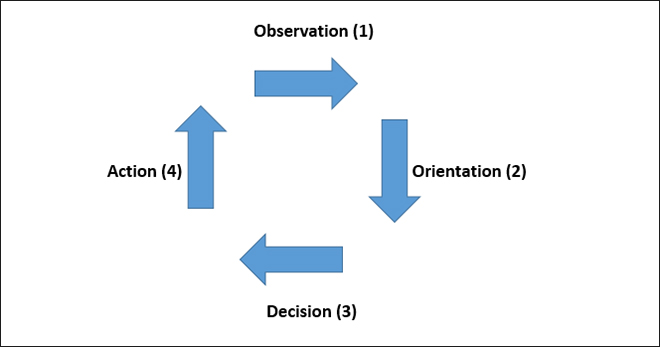
The “OODA” Loop stands for “Observation, Orientation, Decision and Action.” It is an analytical and conceptual framework developed by the American strategist John Boyd. Figure 1 shows a simplified depiction of the OODA Loop theory.[25]Although sometimes erroneously hailed as a solely tactical concept, it is also relevant at the operational and strategic level of war and beyond.[26]This analysis, however, focuses mostly on the operational and tactical understanding of the OODA Loop.
Fig. 1: The “OODA” Loop
Source:Frans Osinga, Science, Strategy and War: The Strategic Theory of John Boyd, (Delft, Eburon Academic Publishers, 2005). p. 2
All major navies seek to gain information superiority based on the seven core areas of MDA.[27]The “taxonomy” of the OODA Loop must cover these core competencies if it is to meet the tempo requirements of the Loop (See Table 2.1).[28]Amongst the seven competencies, two are most significant for effective MDA:Focused Sensing and Data AcquisitionandDynamic Decision Support.[29]
In many respects, Boyd’s conception of the OODA Loop matches Clausewitz’s and Sun Tzu’s views on war and strategy. However, he also drew considerably from other prominent military scholars and historians. The loop is more than the simplified depiction shown in Figure 1; it is characterised by greater complexity. Looking at it sequentially,observationis about assessing oneself and the external environment;orientationencompasses a complex set of factors that includes cultural heritage, cultural preconceptions, personal experience and knowledge;[30]decisionconsiders alternative courses of action and makes a choice about the best one to pursue;[31]andactionis the effective implementation of the final decision. For Boyd, success and effectiveness in war depends on the “quality” and standard of cognitive processes of “leaders and [military] organisations.”Internal or endogenous processes of an organisation determine orientation and decision.The extrinsic or exogenous environment determine observationandaction.[32]Ultimately, the clash in a war is not only a contest of wills but also one between military organisations.[33]Flexibility and speed can be potentially decisive for a navy.
The performance of military organisations in contemporary and modern warfare is conditional on how well they adapt to their environment and execute operations. Adaptation requires agility amongst leaders and organisations, which does not exclusively mean speed, but a dynamic interaction between space and time.[34]Theorientationstage in the loop is crucial as it indicates unpredictable factors such as ambiguity, uniqueness and deception in the external environment, which can be offset by the “internal harmony” of the military commander’s intent, discipline, and training.[35]Although initiative matters, the OODA loop is as much about empathising with the opponent’s observation and orientation, i.e. an organisation’s or commander’s ability to act at the precise time and sow sufficient disorder in the opponent’s decision cycle.[36]It mandates a balance between control and independence, creating true flexibility.[37]
Both in the context of MDA and naval warfare, striking a balance is important. Finding targets at sea is no mean task, since there are very few of them in a vast expanse of water. Without external sensors directing firepower accurately at the enemy’s surface and subsurface capabilities, the task is daunting.[38]Unlike targets in land warfare, ships at sea are constantly moving. In the former, there is considerably greater information to be processed via satellite, and a land contest involves several units operating in closer proximity to each other.[39]At sea, only long-haul communications can link widely spread sources of information and their end-users.[40]Space assets—which enable navigation, reconnaissance, surveillance, detection and precision targeting—increase the efficiency, effectiveness and agility of naval forces. Satellite sensors are invaluable as they reduce the time differential along each stage of the loop and optimise accuracy in information, enabling effective decision-making and action. Space and time are crucial in this regard; the former is about the concentration of military strength at the decisive point,[41]while the latter is about the use of all available force simultaneously.[42]The challenge of command is extracting certainty out of uncertainty. Space sensors will be vital to generating certainty. A decentralised command structure following in the Teutonic tradition of Gerhard Scharnhorst and Helmuth Von Moltke Sr. is indispensable for modern mission-oriented command systems, or what the Germans callAuftragstaktik.[43]The latter applies as much to navies as it does to armies and air forces.
In this context, Martin Van Creveld’s words—on why the interminable requirement of certainty remains the quest of the command system—are significant:
“From Plato to NATO, the history of command in war consists essentially of an endless quest for certainty – certainty about the state and intentions of the enemy’s forces; certainty about the manifold factors that together constitute the environment in which the war is fought, from weather and the terrain [ocean] to radioactivity and the presence of chemical warfare agents; and, last but definitely not least, certainty about the state, intentions, and activities of one’s own forces … The history of command can thus be understood in terms of a race between the demand for information and the ability of command systems to meet it. That race is eternal; it takes place within every military (and, indeed, non-military) organisation, at all levels and at all times.”[44]
The missions and objectives of the IN and its Chinese counterpart matter the most: how well both countries’ naval command systems are adapted to process and use available information with precision to generate MDA and conduct networked fleet operations.
Indian Naval Command Structure and I.W. and Operational Doctrine: The OODA Loop
As explained earlier, centralisation and decentralisation are critical to assessing the command structure of a navy, and the same applies to the IN. Table 1 illustrates a simplified hierarchical command structure of the IN. The IN’s ‘Naval Doctrine for Information Warfare’ incorporates the OODA Loop for application in the naval domain. As the doctrine decrees, “… Naval commanders exercising command and control functions at sea would Observe, Orient, Decide and Act correctly in a much shorter time frame.”[45]This suggests that the speed of command increases across a networked fleet. Space-borne sensors provide correlational data, complemented by other sources. The IN’s IW doctrine divides naval combat power between ‘resources’ and ‘force’. The latter covers all the elements integral to an organisation, including its command structure and its striking power. ‘Resources’ are integral to higher organisations, but lower organisations use them for conducting naval operations. A few of these resources serve as force multipliers, enhancing the application of combat power across the entire spectrum of “military activity.”[46]An optimum fusion between the two, even if the naval forces are few, can enable precision surgical strikes. In naval warfare, precision strikes are key. While the IN’s IW doctrine does consider space assets important for gaining information superiority over the adversary for effective networked fleet operations,[47]its optimum use of space is still deficient in comparison to China’s, particularly if MDA and OTH operations are extended beyond the IOR into the Western Pacific.
The difference in the operational autonomy of a ship and that of the fleet commander (FC) of the IN is reasonable: a critical requirement for a blue-water fleet. The IN’s command system is not very different from its Western counterparts. Nevertheless, an explanation is necessary.
While information is vital in naval warfare, and satellites serve as important external sensors, wars are not fought over information. Information is a means to an end, its purpose being to generate certainty. Therefore, objectives and missions are significant, in addition to the ability of the Indian naval commander to lead and use information and recognise its limitations.
Two aspects ought to be made clear with regard to the level of autonomy the IN’s FCs enjoy:
In peacetime operations, before an FC embarks on a mission, he/she is given an operational order covering most aspects of the mission.
In the event of any unexpected development on the high seas, such as the detection of a sudden military threat, Indian naval FCs are given complete autonomy and independence in determining the best course of action. Initiative is highly valued—instead of merely spoon-feeding FCs or exercising tight control over them—in meeting the threat at hand.
There are two additional factors with regard to mission goals. An FC is given Rules of Engagement (RoE), which may be general or specific to the situation. The RoE lays down guidelines, which explicate the political, military and legal ambit within which the fleet force commander may act. However, if the RoE does not include a specific situation—for instance, when there is a need to militarily engage a hostile target—the FC may need to seek further instructions from the top. In situations where developments unfold at a rapid pace, demanding a premium on decision and action, the commander is counselled to act first and convey later the information about the action to the Naval Headquarters (NHQ).
The IN command system faces two issues that can undermine decision-making and action:
The availability of instantaneous communications links, which can cause both the FC and the NHQ in New Delhi to play it safe, undermining any prompt decision and action.
NHQ puts excessive pressure on the FC or the FC being indecisive despite permission to act on his or her initiative, which can hinder initiative and decisiveness in meeting mission objectives.
Thus, the IN’s command system can undermineAuftragstaktik.No combat simulation, however dynamic, can substitute real naval military engagements.[48]Effective seamanship demands training, both in technical and human terms. Only rigorous training and high morale—two aspects that are not easy to quantify—can increase the probability of success in command. Therefore, the human dimension of command is extremely important, even in a technology–intensive service such as the navy. Therefore, in networked operations, the human attributes of command are indispensable determinants of success or failure in naval operations.[49]
As with the FC, a ship commander—prior to detaching from the fleet for a mission—is issued specific orders. In unanticipated situations, which warrant radio silence, the ship commander has complete autonomy to exercise decisive and quick action. The IN also encourages bold initiative on the part of ship captains just as it does for its FCs.
The challenge for India is therefore not so much the level of operational autonomy a ship commander or a fleet commander wields or even the command system overall. It has the doctrinal elements and command-related practices required for networked fleet operations. The challenge lies in the lack of real capabilities, in both combat vessels and space assets, to sustain force projection beyond the IOR. A dispersed IN force creates vulnerabilities, the most obvious example being the scattering of the IN’s combat power. A two-ocean maritime strategy—which entails deployment across distant waters of the Western Pacific and maintaining a presence in the IOR—requires considerably greater military capabilities than the IN has at present or is likely to have in the near future.
With its existing strength, any extension of the Indian navy’s role to the Western Pacific brings with it difficult challenges. One is simply logistical: operating at significant distance for the IN from the IOR will be expensive. This is true for all navies, including the US Navy and the PLAN.[50]Moreover, replenishing forces at sea is extremely demanding. For instance, battleships that expend their munitions in wartime need to move to calmer waters—away from the main sea battle—to replenish. There are costs imposed due to operating hours for both fixed-wing and rotor aircraft deployed in distant seas.[51]The latter applies as much in peacetime as it does in wartime. Even if deployed in the Western Pacific, as of now, the IN’s flotilla can only operate for short periods. The IN’s maritime strategy lists a set of tasks, missions and objectives for the IN, as seen in Table 2. These tasks, missions and objectives—in substantive terms, limited to the IOR—can be serviced mostly using existing assets. However, the Western Pacific, identified as a secondary area of operations in the Indian Maritime Security Strategy, will certainly require a progressive accumulation of C4ISR capabilities and a larger navy.
Indian Ocean Reconnaissance Capabilities and Naval Combat Vessel Strength: The Importance of Detection, Surveillance and Targeting
This section looks at the static order of battle in the IN and the space assets it can avail for both wartime and peacetime surveillance. First, an assessment of India’s space reconnaissance satellites for ocean surveillance. India has three classes of satellites that are most relevant to this analysis: a) satellites for communications, b) earth observation and c) navigation satellites. All of India’s communications satellites are in geosynchronous orbit, which is generally the case for this class of spacecraft (See Table 4). Their primary function is communications for civilian and commercial use. In 2013, the Indian Space Research Organisation (ISRO) launched a dedicated military communications satellite (GSAT-7) for naval use calledRukmini.[52]It covers approximately 2,000 nautical miles of mostly the IOR.[53]However, across the IOR ocean space, the IN will need precision location and targeting. Communication satellites are necessary but inadequate to meet that requirement. Regardless of whether they are supported by UAVs for gathering electronic intelligence (ELINT), communication satellites are of limited value. For ELINT, these satellites cannot completely identify with accuracy emitters—for instance, from surface vessels for tracking and targeting—since their orbital locations are at a significant distance from the earth’s surface and their beam coverage at the earth’s surface is too broad.[54]Rukminiis the type of satellite most relevant to communications: it enables high-tempo networked fleet operations and augments the IN’s sensor-to-shooter capability.[55]Nevertheless, ELINT requires the least amount of analysis among the three areas of signals intelligence (SIGINT), which include ELINT, communications intelligence (COMINT) and Foreign Instrumentation Signals Intelligence (FISINT) (See Table 6).[56]COMINT, among the space-borne sensors, will play a crucial role in reducing time for processing information and improving the tempo of command.
Although these satellites are valuable, they cannot detect accurately the underwater movement and location of submarines. There are two types of imagery satellites: electro-optical satellites such as Cartosat-1 series of satellites, and radar satellites equipped with Synthetic Aperture Radar (SAR). India also has two radar satellites, RISAT 1 and 2 (See Table 4), which possess nominal submarine-detecting capability. Yet, their resolution, compared to that of their Chinese counterparts, does not sufficiently provide the necessary detection capabilities.[57]India will need a larger number of radar satellites to counter the PLAN’s subsurface fleet.
Conventional non-space and non-aerial detection techniques for subsurface platforms fall into two categories: active acoustic sensing and passive acoustic sensing.[58]Passive detection is when a sensor inserted into the water picks up sound waves generated by the submarine’s propulsion system. Active detection, meanwhile, is when the sensor itself transmits a signal that is reflected off the target.[59]Currently, for non-acoustic detection, India fields and relies on the P-8I Poseidon maritime surveillance aircraft equipped with a Magnetic Anomaly Detector (MAD) for detection of subsurface vessels. The MAD capability of the P-8I is certainly potent, even more so than sonar buoys. However, for Wide Area Surveillance (WAS) detection of undersea platforms, maritime aircraft—such as the Poseidon, for wide area anti-submarine detection—suffer from the same limitation as their space-borne and UAV counterparts: their search and detection area is quite limited.
As one group of Chinese experts said recently: “… [airborne] magnetometers are suitable for invisible conditions because these instruments passively detect underwater submarines. Compared with sonar buoys, magnetometers are not affected by hydrological and meteorological conditions; as such, magnetometers are more reliable than sonar buoys. Magnetometers are free from the effects of propagation characteristics [of seawater]; these instruments also exhibit strong target discrimination and high-precision positioning. When sea conditions reach above the fifth level, only magnetometers can be used to search for submarines. However, magnetometers cover a small range; furthermore, magnetometers are generally used for confirmation and precise positioning only after other devices have found the approximate location and information of a submarine. Magnetometers can be used for searching when a sea search area is small and narrow or when submarine manoeuvring is limited.”[60]
The P-8A, the American version of the P-8I is “… not effective for the intelligence, surveillance and reconnaissance mission and is not effective for wide area anti-submarine search,” observed the Pentagon’s principal weapons inspector, Michael Gilmore.[61] Moreover, as the quote from Chinese experts reveals, magnetometers are mostly used to confirm information and approximate location of a submarine gathered from other devices. These other devices and information sources include passive space-borne assets, UAVs and UUVs. Therefore, no single sensor-detection technique is sufficient for NAASW. Combined, however, all these sensors will augment India’s C4ISR capability and targeting in the IOR.
Maritime surveillance aircraft, as is the case with UAVs, are low-endurance platforms. For wide-area surveillance (WAS), a 24-hour and near-complete coverage of the ocean, an LEO (Low Earth Orbit)-based ISR capability is necessary. The Bay of Bengal has great ocean depth, making it an ideal sea area for subsurface operations.[62]
As the IN’s IW doctrine states, “They [satellites] will also have shorter ‘between passes’ periods,”[63]which significantly increases the possibilities for detection and makes PLAN vessels operating in the IOR more trackable and, ultimately, more targetable. Therefore, to service the “spatial [resolution] and temporal requirements of WAS,” an LEO-based surveillance system is necessary.[64]Spatial resolution relates to the detectability of the smallest object, whereas temporal resolution refers to the revisit period of a satellite over swathes of sea or land.
Submarines create a wake as they move underwater. A wake occurs when the structure of the water changes due to submarine movement, which satellites sensors can help detect.[65]There are two types of wakes: external and internal. The first is the Kelvin ‘V’ wake that all surfaced vessels, including surfaced submarines, create. However, a submerged vessel is more difficult to detect, especially the internal waves that a moving submarine creates. The effectiveness of space-borne detection is conditional on the depth and speed of a submerged vessel. Indeed, as American naval expert Norman Polmar observed, “A submarine is a relatively small, finite object – perhaps 300 to 500 feet [91 meters to 152 meters] in length in most cases – but the submarines wake is persistent and stretches out for miles.”[66]There is a long history—going back to the Cold-War era—of detecting submarines wakes by enabling space sensors.[67]Submarines will be crucial in a naval contest between the PLAN and the IN in the IOR, let alone the Western Pacific. If the IN is to meet the ASW WAS requirements in the IOR, it needs to invest in space-borne sensors. The problem for India is not exclusively (or even overwhelmingly) China’s subsurface nuclear capability but its conventional submarines, which are widely considered very advanced in terms of quietness and endurance.[68]In this context, an Indian space-borne capability is also crucial in supplementing maritime surveillance aircraft, UAVs and UUVs for detection of the PLAN’s subsurface forces operating in the IOR and beyond.
However, just as with maritime surveillance aircraft and UAVs, satellite sensors alone cannot help in NAASW. A satellite, or even multiples satellites, can only make overhead passes, surveying and collecting intelligence over limited swathes of sea area. Combined, however, they can detect the submarine’ wake through correlational data. This will help the IN get inside the OODA Loop of the PLAN.
A specialised low-altitude or LEO space-borne satellite constellation is indispensable for India. As of now, the country does not have a specialised ELINT and SIGINT constellation of satellites for precision location (See Table 4). The satellite segment of ISR is the least complex end of the problem, and all the information that it provides must be processed and converted into tactical or useable intelligence. All emissions from the PLAN’s surface vessels picked up by a prospective or potential Indian space ELINT capability need collation and interpretation, which ELINT ships and aircraft can enable[69]by fingerprinting the ships radars. A dedicated ELINT spacecraft capability is a force multiplier for the IN. It can provide crucial correlational data, which is essential in generating awareness in the maritime domain and, in turn, certainty of command.
Satellites are also vital for navigation to execute precision missile strikes against surface forces. India’s space navigation system is the Indian Regional Navigation Satellite System (IRNSS), called the “Navic.” This navigation system is entirely indigenous, although its navigation coverage is limited compared to the American GPS.[70]It offers positioning, navigation and timing (PNT) across the Indian landmass and 1,500 km beyond its coast and borders. One part of the service is for all users and the other is restricted service, meant only for authorised users such as the Indian military.[71]This space navigation capability is invaluable for a credible cruise missile capability.
The denial of American GPS access to the Indian military during wartime fuelled the development of IRNSS.[72]“Navigation warfare,” intended to deny an enemy navigation capability, was the key reason Americans would not extend GPS services even to allies.[73]The French decided not to avail GPS guidance for their Apache cruise missile.[74]Space-based satellite navigation is highly susceptible to jamming,[75]although this has not prevented the US from using GPS for cruise-missile guidance. The Chinese, too, have built their own constellation of navigation satellites called theBeidou,which is larger than the IRNSS.The BrahMos used an American GPS signal for guidance. A 2009 test failure of the BrahMos was attributed to a GPS signal being switched off, leading to the development of IRNSS.[76]India has divested its dependence on the GPS and GLONASS for its missile forces. The naval variant of the BrahMos is an anti-ship missile and gives the IN OTH-T capability, much like China’s surface fleet.[77]It is a supersonic missile travelling at Mach 3, with a range of 290 km. The BrahMos’ range is likely to increase with India’s entry into the MTCR. Even if a hypersonic variant of the BrahMos is developed, it will need precise targeting data, partially supplied by satellites to be effective.[78](China faces the same issue with their own hypersonic capability.) However, the lack of a potent satellite-guided SLCM capability remains the weakest link in the IN’s inventory.
In addition to theRukmini,India uses a combination of UAVs and maritime surveillance aircraft, e.g. the Poseidon P-8I, for tracking, locating and identifying naval targets at sea. The IN’s UAVs and maritime surveillance aircraft are excellent platforms to detect the presence of naval vessels for both surface and subsurface vessels. However, UAV’s have one significant disadvantage: they are highly localised, with limited endurance. A space-based sensor capability augments the strength of the IN’s precision location capabilities within the IOR. The other critical benefit of possessing an ELINT satellite constellation is that it enables precision targeting of the PLAN’s surface fleet. Ultimately, an Indian space-borne ELINT capability will deny the PLAN any sea sanctuary, at least when the PLAN’s surface fleet is operating in the IOR. This is the reason the Chinese have invested so heavily in an LEO ELINT capability of their own (See Table 3).
The IN must economise on its available shipboard munitions, given the smaller size of the IN fleet compared to the PLAN’s (See tables 9 and 10). External space sensors are vital for a numerically inferior IN to strike the PLAN’s surface forces with surgical precision. Across the entire spectrum of space-naval military capacities, the IN is vastly lagging behind PLAN. Today, India faces a massive shortfall,[79]both within the commercial and civilian space segment and within the military segment. Therefore, the static space-sensor balance does matter. An Indian space-borne ISR capability reinforces certainty and enables the IN to penetrate the OODA Loop of the PLAN. Indeed, as Friedman observed about space-borne capabilities, “The only hostile capability which would probably depend uniquely on an enemy country’s satellites would … be electronic surveillance.”[80]
Space-based ISR sensors are a core weakness of the IN’s IW and targeting capability, and India must invest in this area to counter the PLAN’s existing strength and expansion over the next decade. Failing this, India will be restricted to deploying and employing mostly ‘poor man’s satellites’. While airborne and underwater sensors are necessary, they must be supplemented with space-based sensors. Whether India invests in a larger fleet or more space sensors to sustain its existing fleet, the advantage of the country’s geographic asymmetries will shrink if the PLAN secures basing rights within the IOR. Indeed, its staying power in the IOR will increase significantly.
PLAN Command Structure and the I.W. Doctrine
For much of its history, the PLAN was a coastal defence force that undertook operations to support military campaigns on land. Since the early 2000s, China has moved rapidly from quantity to quality by developing wide range of naval platforms and their supporting sensors.[81]The PLAN has five main service arms, which include surface, naval aviation, coastal defence, Marine Corps and submarines.[82]Its navy is divided into three fleets in the North Sea, the East Sea and the South Sea (See Table 1.2). With the introduction of CMC reforms in 2015, its command structure has undergone significant changes. The Chinese military has always been a PLAGF (People’s Liberation Army Ground Force)-dominated organisation, reflecting the continental orientation of the Chinese state.[83]However, with the advent of President Xi Jinping’s reign since 2012, the Army-dominant PLA’s power has been curbed significantly. The PLA ground forces are undergoing massive manpower reductions, and the service has already undergone an extensive anti-corruption crackdown under President Xi’s ‘reforms’.[84]This dramatic restructuring means that the PLA is now a subordinate service or at best co-equal to the other military arms, most specifically the PLAN and People’s Liberation Army Air Force (PLAAF). The latter two services have been elevated to a more prominent role. A Navy-centric Chinese military posture is already evident from the recent establishment of a military base in Djibouti.[85]This base facility is unlikely to have a significant effect on the IN’s power projection within the IOR,[86]but it does portend the arrival of a naval actor in the IOR that could grow, diminishing some of the geographic advantages that Indian naval power currently enjoys in the IOR. The CMC reforms have brought a significant shift in decentralisation in the command structures of the Chinese military and the PLAN itself has undergone a significant change. These reforms have reduced the earlier seven military regions (MRs) into five theatre commands (TCs). The TCs control their respective service commands: PLA (A), PLA (AF) and PLASAF.
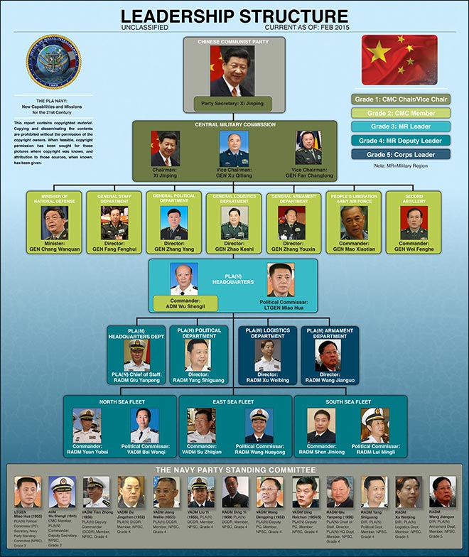
The distinctive feature about the PLAN’s three fleets is that they have their own theatre service commands, which is not the case with the US Navy[87]or the IN. It is only reasonable to infer thatsomedecentralisation essential to conducting blue-water naval operations is now in place. As it appears, fleet commanders of the PLAN do enjoy greater operational autonomy. Centralisation is relevant mostly for coastal defence forces and brown-water navies. One crucial difference between the IN and the PLAN is that each of the latter’s fleet commanders have a political commissar attached (the rank of a Vice Admiral), a continuance of a practice from the PLAN’s past and similar to the current Soviet practice (See Figure 2).[88]Whether the command structure continues to be as shown in Chart 1 is unclear. The attachment of a political commissar to each of the fleet commands represents an effort to ensure the PLAN remains loyal or the “Party’s [CPC] Navy”.
Figure 2. PLAN Leadership Structure Chart
Source:U.S. Navy Office of Naval Intelligence, 2015.
As the Official Chinese document titled “China’s Military Strategy” released in 2015 states: “… the armed forces will uphold a series of fundamental principles for and institutions of the CPC’s absolute leadership over the military … ensure that the armed forces will resolutely follow the commands of the CPC Central Committee and the CMC at all times and under all conditions, and consistently retain the nature and purpose of the people’s armed forces.”[89]
A centralised command architecture may have two operational consequences:
Chinese central-level decision-makers become wary of allowing PLAN commanders to show initiative and thus embed a political commissar with the fleet commander.
The command system potentially undercuts the PLAN’s capacity to remain mission-oriented.
However, it is hard to be categorical about the relative balance between centralisation and decentralisation in the command structure for the PLAN’s conduct of naval operations. While the Chinese have made significant progress in both naval hardware and associated space-borne investments, the demands on collating information from their satellite network is a challenge that they recognise. The PLAN must contend with the human attributes of command, just as the IN has to. The problems ofAuftragstaktikwill affect the PLAN as it does the IN. Chinese military planners do recognise the importance of “directive control” undergirdingAuftragstaktik(or ‘mission command’) and have sought to create “realistic” exercises for MDA and naval operations.[90]Therefore, Indian force planners cannot leave things to chance since the PLAN has impressively expanded its capacity for a range of naval missions.
China’s IW capabilities are significant, having traversed a great distance in establishing a networked fleet. Its space-based sensors perform a key role in this networked force. The concept of “informationisation” is central to China’s military modernisation and similar to that of many countries, including India. The fundamental features of “informationisation” are similar to the IN’s IW doctrine.
The PLAN is integral to the effort to informationise warfare, and the space segment has found a very specific focus. Reducing the gap between China and advanced militaries in the world across the entire spectrum, military hardware has received priority. One salient feature of the PLAN’s modernisation is heavy investment in education and training for wars under informationised conditions. The crucial difference between the PLAN and the IN is that the Chinese have invested significantly in hardware to cover the needs of C4ISR, which were weak until the late 1990s to early 2000s.[91]Chinese IW capabilities are geared to penetrate “the enemy’s information detection sources, information channels, and information-processing and decision-making systems.”[92]This is similar to the OODA Loop enshrined in the IN’s IW doctrine. The other distinctive feature of China’s maritime strategy is its commitment to pursuing OTH-T operations. China is obsessive about precision strikes against distant targets.
As one subset of Chinese naval officers in the late 1990s observed: “The concept of using tactical mobility of all weapons delivery platforms to first seize advantageous positions and then attack will likely become obsolete or even disappear, with long-range battle concepts such as ‘remote grappling’ and ‘over-the-horizon strikes’ becoming the key forms of battle in future naval warfare (such as attacks against surface ships, missile defense, air defense, and strikes on land – or space-based targets).”[93]
With regard to surface warfare OTH-T operations, the IN fares better and could very well hold its own, but it must deal with a crucial disadvantage, i.e. the lack of satellite-guided SLCM subsurface capability.
Chinese Ocean Reconnaissance Capabilities and Naval Combat Vessel Strength: The Importance of Detection, Surveillance and Targeting
Since the 1990s, a naval-oriented approach is evident in the vast majority of Chinese writings on the maritime posture that the PLAN should adopt.[94]On the one hand are conservative requirements for a coastal defence and, on the other, the need to extend operational range to distant seas.[95]Assessed chronologically and empirically, China’s maritime strategy evolved from “near coast defence” prior to the 1980s, to a “near seas active defence” from the mid-1980s, to a dramatic shift by the mid-2000s to “far seas operations.”[96]Complementing and undergirding these shifts in Chinese maritime strategy are improvements in the PLAN’s actual naval capabilities,[97]which are the PLAN’s strength.
As Friedman put it rather presciently almost two decades ago, “… any country interested in denying the United States the sea sanctuary would have to invest in a low-altitude (for precision location) ISR system for that purpose.”[98]Chinese military planners have gone about doing just that, and one can reasonably infer India will be—in a similar way, if not identically—subject to the same denial of sea sanctuary. Indeed, the expansion of PLAN’s presence through basing in the IOR is likely to crystallise in Chinese naval consolidation in the IOR. China’s space programme has played a pivotal role in augmenting the PLAN’s exploitation of space-borne assets as a force multiplier. The PLA’s Strategic Support Force (SSF) manages all Chinese space systems, early warning capabilities, and electromagnetic and cyber warfare operations.[99]Satellite capabilities are vital for precision location and targeting, particularly for navies. The difference is no less consequential in the space segment.
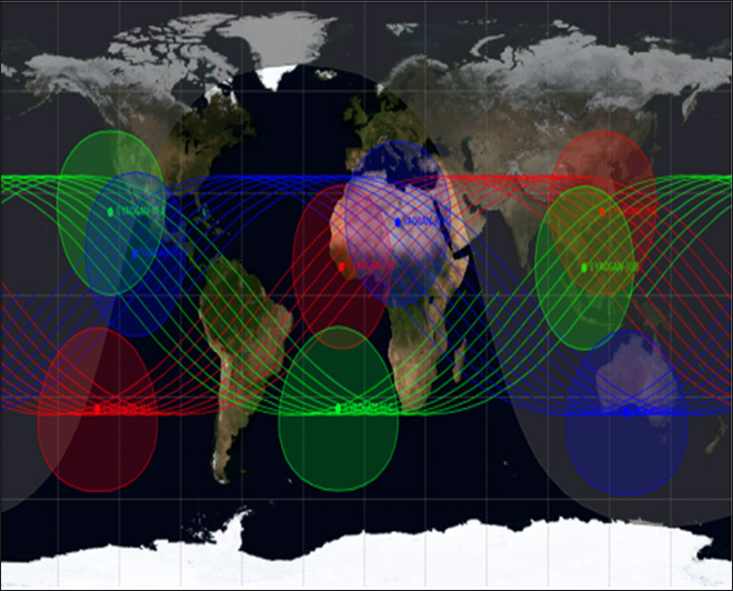
China, as Erickson and Chase observe, “possesses dedicated ELINT and SIGINT satellites.”[100]India, however, has limited ELINT satellite capabilities. As the data clearly indicates, the extent of China’s space-borne ELINT capabilities are significant (See tables 3 and 4). TheYaoganconstellation of satellites placed in Low Earth Orbit (LEO) move and operate in clusters of three. The latest to join the current 35 satellites in orbit is another triplet launched in September 2017.[101]This satellite constellation provides round-the-clock and complete coverage of the earth.[102]The advantage of triplet satellites orbiting in close formation is that they can triangulate and pinpoint with accuracy electromagnetic signals from a source, which a single satellite cannot detect or identify (see Yaogon triplets groundpath in Figure 3).[103]The temporal resolution of theYaoganConstellation over an area is high, which gives the Chinese complete coverage. They are very similar to the US’ National Ocean Surveillance System (NOSS).[104]TheYaogansatellites significantly enable precise target location, linking them to China’s land-based Anti-Ship Ballistic Missile (ASBM) capabilities, but also to its sea-based forces. China’s space-borne capability also aids in precise location of targets for its Anti-Ship Cruise Missile (ASCM) capability known as the Y-18. The ASCM missile system is possibly the most widely dispersed in the Chinese naval missile inventory, with a range of 290 nautical miles (NM) using high probability waypoint navigation with the aid of itsBeidousatellite constellation.[105]Another missile called the CM-708 UNB is a derivative of the longer-range version of the YJ-82.[106]A submarine-launched missile, the CM-708 UNB is also satellite guided.[107]Its estimated terminal velocity is Mach 5–7, or five to seven times the speed of sound.[108]A hypersonic sea skimming missile with a range of approximately 130 km, the CM-708 UNB significantly expands the PLAN’s offensive missile range against surface targets.[109]
Figure 3. Groundpath of Yaogan Satellites Triplets
Source:SatelliteObservation.net
In addition to the ELINT/SIGINT satellites, China possesses IMINT spacecraft, which are a dedicated mixture of electro-optical and SAR satellites known as theGaofengconstellation or the “Superview” satellites, consisting of 16 optical satellites with a resolution of 0.5 m resolution, four higher resolution satellites, four synthetic aperture radar satellites and a fleet of video and hyperspectral satellites (See Table 3.1).[110]This constellation of IMINT spacecraft are part of the China High-Resolution Earth Observation System (CHEOS).[111]IMINT spacecraft mostly orbit in LEO, whereas SIGINT satellites have higher orbits. TheGaofeng-3 radar satellite launched in 2013 is widely considered one of the most advanced radar satellites in operation today. By 2021–22, the entire CHEOS constellation will become fully operational.[112]The SAR component gives a fillip to China’s space-borne capabilities for subsurface vessel and wake detection. It provides round-the-clock real-time, all weather global imagery surveillance. Supplementing these capabilities are China’s Tianlian Data Relay Satellites (TDRS) mostly in a geostationary orbit (See Table 3.2). The TDRS tap the uplink from China’s lower-orbiting satellites and, thereafter, relay communications to ground stations and relay commands from the ground to the relay satellite, which in turn transmits to the designated spacecraft.[113]It also provides in-orbit communication between satellites.[114]India, however, does not have dedicated data-relay satellites in the space segment.[115]As the ISRO scientists documented, the advantages of having TDRS are five-fold. First, it enables communications in all orbits, including Telemetry, Tracking and Commanding (TTC) functions in LEO. Second, it can provide data services in minutes instead of hours, allowing the user instant access to data.[116]Third, the laser and communications technologies on board the spacecraft can enable rapid and high-volume data transmission. It is estimated that the transmitted information can reach up to several gigabits per second and reach data transmissions capacity for terabits a day for DRSS users.[117]Fourth, end-to-end use in LEO is considerably simplified by transmitting data through space-based infrastructure instead of ground stations, which is more time-consuming.[118]Fifth, it preserves data security by circumventing sovereignty issues for transmission of information through alien territory or infrastructure.[119]At the moment, the Tianlian TDRS capability gives China an advantage over India.
In addition, the PLAN’s “Surface Action Groups” (SAGs) have undergone substantial expansion and improvement. Most of these surface vessels are modern multi-mission platforms and cater to a variety of tasks (See Table 7).[120]Although some questions regarding the quality of Chinese hardware remain unanswered, in quantitative terms, there is absolutely no comparison between the IN and the PLAN. The PLAN’s fleet of destroyers alone matches the strength of the entire IN surface combat fleet (See tables 7 and 9). China has both ground-based OTH radars and space-based NOSS, vital for cueing the PLAN’s surface forces against the enemy’s surface navy.[121]Indeed, China’s existing ASBM greatly relies on target acquisition and location information provided by theYaogansatellites against carrier strike groups operating in the Western Pacific, and these spacecraft help cue missiles to strike targets.[122]The orbital positions and trajectories of theYaogansatellites, particularlyYaogan 9,Yaogan 20andYaogan 16, are adequately separated to be able to make 18 contacts with a moving sea-based target in a single day.[123]Pass duration between satellites is calculated to be approximately 23 minutes.[124]
Nevertheless, the PLAN’s surface fleet is a relatively easier to target for the IN at least when operating within the IOR. The surface fleet is the strongest segment of the IN. However, the real concern for India and the IN ought to be the PLAN’s conventional subsurface fleet, which has increased significantly (See Table 8). The PLAN’s conventional undersea leg is widely considered very advanced.[125]Within the fleet, the YUAN Class submarines are the most sophisticated in terms of non-detectability and high endurance. Equipped with an Air Independent Propulsion (AIP) system and fitted with the YJ-18 long-range cruise missiles, they will be formidable against the IN’s surface and subsurface forces.[126]China’s other submarines—the SONG and SHANG Class—are also equipped with the YJ-18. None of India’s existing or operational submarines is equipped with an AIP capability.[127]Currently, except for a single vessel, none of the under-construction Scorpene Class submarines is likely to be fitted with an AIP system.[128]
As in the past, China continues to undertake bathymetric assessments of the Indian Ocean. Surface and subsurface vessel deployments have been accompanied by the deployment of oceanographic, hydrographic and espionage vessels in the IOR to map the ocean floor.[129]In 2017, China deployed the spy shipHaiwngxingto gather electronic intelligence.[130]It is only reasonable to infer that a good part of this ELINT was, and continues to be, sourced from China’s space-borne sensors. While the IN’s senior officials claim they have sound MDA capability within the IOR, this is insufficient. To fulfil MDA-related missions beyond the IOR, India will need a greater expansion of naval and space assets. Many passive external space sensors provide additional or correlational source of information. They will also enable the IN to gain more expertise in fusing and optimally utilising intelligence collected from space-borne sensors with airborne and underwater sensors.
In contrast, due to budgetary shortfalls, the IN cannot expand the strength of its fleet. Its projected needs far exceed what the Indian government can or is ready support.[131]Under these circumstances, the IN must focus on investments in external sensors such as satellites. These space-borne capabilities will augment the IN’s MDA capability and battlespace awareness.
Based on the analysis, the IN has some advantages operating in the IOR, such as geography. In terms of command and control and operational doctrine, the differentials between the IN and PLAN are not too significant. Both countries face the common challenge ofAuftragstaktikor remaining mission-oriented.
However, a vast hardware gap exists both in the space and naval segment. India, like China, already has surface based OTH-T capability even as it lags behind the PLAN’s sub-surface OTH-T capability. India will have to contend with diminished superiority in the IOR due China’s acquisition of bases, which is, in many respects, a priority for the Chinese.[132]The IN cannot match the PLAN’s significantly greater strength in surface and subsurface combatants, but in the space-sensor segment, India can augment its C4ISR capabilities, which will create a force multiplier for the IN. This is in line with the OODA Loop enshrined in India’s IW doctrine and the MDA mission articulated in the IN’s Maritime Security Strategy.
Recommendations for India
Indian decision-makers and Indian Naval Force Planners continue to accumulate naval capabilities and support sensors at the current laggard pace. This can, in turn, place limits on the number of space-borne sensors due to fears of China’s ASAT capability destroying Indian spacecraft, constraining India’s militarisation of space. As is the case with the current practice, the IN will have to rely mostly on airborne and underwater sensors. The hybrid approach recommended here ensures that IN’s operational range is not confined to the IOR alone, necessitating an extension into the Western Pacific. In addition, it will need a focused mission-oriented approach, investment in training and initiative. Space sensors will also be crucial for the IN’s fleet. It will help the IN’s ship and submarine commanders to offset weaknesses in surface and subsurface forces vis-à-vis the PLAN.
If the fear of China’s kinetic capability fetters India’s development and investments in space sensors for greater MDA and battlespace awareness, Indian decision-makers will have to review the restraint on kinetic space weapons development and testing. As things are, India’s existing space assets are a ready target for a Chinese kinetic attack. Under the option offered in this paper, India can weaponise its space-borne assets in parallel with its civilian and commercial investments in space. While this option poses considerable political risks, the military gains are high, since India would have a proven and tested space weapons capability. It will help create shared vulnerability and poses a countervailing asymmetric threat against China’s space-borne infrastructure.
Finally, India can proceed with militarising its space programme, withoutactuallyweaponising it, by investing in dedicated military satellites that perform ELINT and SIGINT functions to generate greater MDA for the navy. This will accelerate the tempo of command during wartime. It will give the IN NAASW capability, thereby expanding MDA and generating greater battlespace awareness for IN commanders during wartime.
While the hybrid alternative offered in this paper still leaves India’s space-borne assets vulnerable to Chinese anti-satellite attacks, it is the most viable option at the moment, as it is politically and internationally justifiable.
Author
Kartik Bommakanti is an Associate Fellow with the Strategic Studies Programme at the ORF, New Delhi. He specialises in space-military and Asia-Pacific security issues. He has published extensively in peer-reviewed journals.
ANNEXURE
Table 1. Skeletal Hierarchy of IN
President Of India
Supreme Commander of the Armed Forces of India
Defence Minister
Cabinet Rank from the Council of Ministers of Government of India
Indian Navy
One of three wings of Armed Forces of Indian Union
The Chief of Naval Staff
An Admiral Rank Officer
At Integrated Headquarters MOD (N) Level
At Operational Commands
Vice Chief of Naval Staff
Flag Officer Commanding in Chief, Western Naval Command
Deputy Chief of Naval Staff
Flag Officer Commanding in Chief, Eastern Naval Command
Chief of Personnel
Flag Officer Commanding in Chief, Southern Naval Command
Chief of Material
Other Independent Authorities
Commander in Chief
Other Independent Authorities
Source: Indian Navy
Table 1.1 IN Operational or Fleet Commands
Station
Commands
Head
Command Authorities & Units
Mumbai
Western Naval Command (WNC)
Flag Officer Commanding in Chief.
Units of WNC
Vishakhapatnam
Eastern Naval Command (ENC)
Flag Officer Commanding in Chief
Units of ENC
Kochi
Southern Naval Command (SNC). Primarily training command.
Flag Officer Commanding in Chief
Units of SNC
Port Blair
Andaman & Nicobar Command (ANC)
Commander-in-Chief
Units of ANC
Source: Indian Navy
Table 1.2 PLAN NAVAL COMMANDS
Station
Commands
Behai
North Sea Fleet
Donghai
East Sea Fleet
Nanhai
South Sea Fleet
Source: Military Balance, 2017 IISS
Table 2 Tasks, Missions and Objectives of the IN
Tasks
Missions
Objectives
Surveillance
Nuclear Second Strike
Decisive Military Victory in case of War
Patrol
Maritime Domain Awareness
Defence of India’s Territorial Integrity, Citizens and Offshore Assets from Seaborne Threats
Maritime Strike
Sea Control
Influence Affairs on Land
Anti-Submarine Operations
Sea Denial
Safeguard India’s Mercantile Marine and Maritime Trade
Anti-Surface Operations
Blockade
Safeguard India’s National Interests and Maritime Security
Anti-Air Operations
Power Projection
Amphibious Operations
Force Protection
Information Operations
Expeditionary Operations
Electronic Warfare Operations
Compellence
Protection of Offshore Assets
Destruction
NCAGS & NCS Operations
SLOC Interdiction
Mine Warfare
SLOC Protection
Visit, Board, Search and Seizure (VBSS)
Special Forces Operations
Harbour Defence
Seaward Defence
Coastal and Offshore Defence
Source: Maritime Security Strategy. Only includes military tasks, missions and objectives.
Maritime Domain Core Functions Table 2.1
MDA’s Functional Imperatives
Description of Functional Imperatives
Focused Sensing and Data Acquisition
Commanders require situational awareness over the battlespace. It requires more detailed information in some areas than others areas. To gain situational awareness data gathering is necessary through electromagnetic, acoustic, seismic, optical and other measurement methods. These can be accomplished through platform-based sensors or with the aid of external sensors, such as unmanned platforms, satellites and other intelligence sources. Focused sensing is concentrated on things of interest. The purpose is to avoid gathering too much information to the point of overwhelming the operator.
Dynamic Interoperable Connectivity
Serves as a pathway or conduit for all information. Information is transparent to the user. It collected from a variety of sources, machine, people and locations. It must dynamically address the real-time needs of the warfighter and meet information demands with changing scenarios.
Responsive Information Management
The Internet is vital for communication to sustain Responsive Information Management. Information Technology (IT) enables the warfighter gain an information advantage. Information cannot be excessive to the point of being overwhelming, but rather be independent of technical complexity and easily accessible to users or commanders with a non-technical background. Three imperatives need to be balanced to gather information: user information pull, producer information push, and preplanned information ordering. The first is information can be accessible when needed to all users, Producer push is information igenerated by higher headquarters or central command authorities when warfighters have inadequate knowledge to create a request. Preplanned information includes information that is assemble before a mission and also involves information that is automatically updated during a mission. Collaboration instruments must work at different command levels and between and among multiple organisational locations and job functions.
Information Assurance
It is about gaining an information advantage over the opponent. The necessity for creating information superiority to defeat an adversary. will require the a potent C4ISR capability. Information Assurance is equally about protecting information from the adversary’s penetration and sabotage. Confidentiality and integrity of information disseminated is crucial.
Consistent Representation
Human comprehension of complex information must involve shares awareness at all levels of command. Information is collected, fused, processed and presented consistently for commander the intentions, trends and assess unfolding events. The information displayed has to be support the decision-maker or commander.
Distributed Collaboration
Distributed collaboration involves the maintenance of fully connected and transparent interactions, providing tools and connectivity at the user level. These instruments must support geographically dispersed forces. System operators must assist warfighters in the battlespace in the areas of online planning, coordination and synchronised execution. The operators have to be IT-enabled to help warfighters.
Dynamic Decision Support
Resource allocation to meet operational demands. Mission success depends on available resources. Supporting warfighters requires that the allocation of information must be agile and flexible. C4ISR have to be designed to determine the status of friendly and enemy forces.
Source: U.S. Navy Center, San Diego.
Table 3 Chinese Satellites
Communications
Zhongxing, Dual-use Telecom Satellites for civilian and military applications (Geostationary Orbit)
Table 3.1 China’s Operational Electro-optical and SAR Satellites
Gaofen 1
SSO Orbit, Multispectral colour imagery and panchromatic
Gaofen 2
SSO Orbit, Multispectral colour imagery and panchromatic
Gaofen 3
LEO, SAR with I meter resolution and swath of 650 kilometres.
Gaofen 4
GEO, Optical imaging satellites. Coverage intended for 24 hour.
Gaofen 5
SSO Hyperspectral imagery, infrared camera, environment and greenhouse monitoring instruments.
Gaofen 8
Polar Orbit, Optical satellite with high-resolution imaging.
Gaofen 9
Polar Orbit, three dimensional earth observation imagery. Panchromatic sensor with a spatial resolution of 0.5 meters and multispectral or colour with a resolution of 2 metres.
Source: China space Report
Tianlian Chinese Data Relay Satellites – Table 3.2
Launch Date
Payload
Orbit
2008
Tianlian – 1- 01
Geosynchronous Orbit
2011
Tianlian – 1 – 02
Geosynchronous Orbit
2012
Tianlian – 1 – 03
Geosynchronous Orbit
2016
Tianlian – 1 – 04
Super sunsynchronous Orbit
Source: China Space Report and Spaceflight 101
Table 4 Indian Satellites
Communication
Indian National Satellite System (INSAT)
15
Intelligence, Surveillance and Reconnaissance
Indian Remote Sensing Satellites (IRS) 9 in Sun synchronous Orbit (SSO) 4 in Geostationary Orbit (GEO).Only 1 Cartosat 2C and 2 RISATwith SAR Capability
13
Navigation/Positioning/Timing
Indian Regional Navigation Satellite System (IRNSS):NavIC3 in Geostationary Orbit (GEO) and 4 in Geosynchronous Orbit (GEO)
Fall into three categories: Electronic Intelligence (ELINT), Communications Intelligence (COMINT) and Foreign Instrumentation Signals Intelligence (FISINT).
Table 7
Current PLAN Principal Surface Combatants
Aircraft Carriers
1
Destroyers
21
Frigates
57
Corvettes
27
Minesweepers
41
Total
147
Source: Military Balance 2017.
Table 8
Current PLAN Principal Subsurface Combatants
Strategic (Nuclear) – SSBN
4
Tactical (Nuclear) – SSN
5
Tactical (Conventional) – SSK
47
SSB – (SLBM Undergoing trials)
1
Total
57
Source: Military Balance 2017
Table 9
IN Surface Combat Vessels
Aircraft Carriers
1
Destroyers
11
Frigates
12
Corvettes
19
Source: Indian Navy
Table 10
IN Submarines
Conventional
14
Nuclear
1
Source: Indian Navy
[1]The Military Balance: 2017,(London: UK, Routledge, 2017), p. 279.
Endnotes
[1]Norman Friedman,Seapower and Space: From the Dawn of the Missile Age to Net-Centric Warfare(Annapolis, MD: Naval Institute Press, 1999), 195.
[10]See distinctions on brown, green and blue waters navies, Paul Pryce, “The Brazilian Navy: Green Water or Blue?” Centre for International Maritime Security (CIMSEC), 27 January 2015.
[11]James R. Holmes and Toshi Yoshihara, “China’s Naval Ambitions in the Indian Ocean,”The Journal of Strategic Studies31, no.3 (June 2008): 372.
[12]Alfred T. Mahan,The Influence of Seapower Upon History: 1610-1783(Boston: Little Brown and Company, 1898), 26.
[17]Maritime Domain Awareness: The Key to Maritime Security Operational Challenges,Space and Naval Warfare Systems Center, San Diego, Office of Science, Technology and Engineering, June 2006,http://www.dtic.mil/dtic/tr/fulltext/u2/a463128.pdf.
[18]See also Steven C. Boraz, “Maritime Domain Awareness: Myths and Realities,”Naval War College Review62, no. 3 (Summer 2009): 137–46.
[19]Darshana M. Baruah, “Expanding India’s Maritime Domain Awareness in the Indian Ocean,”Asia Policy22,July 2016, 49–55.
[21]Andrew S. Erickson and Michael S. Chase, “Informatization and the Chinese People’s Liberation Army Navy,” inThe Chinese Navy: Expanding Capabilities, Evolving Roles, eds. Phillip C. Saunders, Christopher Yung, Michael Swaine and Andrew Nien-dzu Yang (Washington D.C.: Center for the Study of Chinese Military Affairs, Institute for National Strategic Studies, National Defense University, 2011), 256.
[25]Frans Osinga,Science, Strategy and War: The Strategic Theory of John Boyd,(Delft: Eburon Academic Publishers, 2005), 2.
[26]Lt. Col. Jeffery N. Rule, “A Symbiotic Relationship: The OODA Loop, Intuition and Strategic Thought,”Research Project,United States Army War College (Carlisle Barracks, PA: USAWC, 2013), 5–6.
[27]Maritime Domain Awareness: The Key to Maritime Security Operational Challenges,12–13.
[48]Friedman, “Shaping Naval Power: Implications of the Naval Build-up in Asia,” 130.
[49]Colonel Pierre Forgues, “Command in a network-centric war,”Canadian Military Journal,Summer 2001, 23. See also for effect of psychological factors Friedman, “Shaping Naval Power: Implications of the Build-up in Asia,” 130.
[50]Friedman, “Shaping Naval Power: Implications of the naval build-up in Asia,” 132.
[51]Interview with former Senior Indian Naval Officer.
[56]Maj. Brian Crothers, USAF, Maj. Jeff Lanphear, USAF, Maj. Brian Garino, USAF, Maj. Paul P. Konyha III, USAF and Maj. Edward P. Byrne, USAF, “US Space-Based Intelligence, Surveillance, and Reconnaissance,” 175,https://media.defense.gov/2017/Mar/15/2001717230/-1/-1/0/AU-18.PDF.
[57]Tapan Mishra, S.S. Rana, N.M. Desai, D.B. Dave. Rajeevjyoti, R.K. Arora, C.V.N. Rao, B.V. Bakori, R. Neelakantan and J.G. Vachchani, “Synthetic Aperture Radar Payload on-board RISAT-1: configuration, technology and performance,”Current Science104, no. 4 (25 February 2013): 447–448. Also see S. Chandrashekar, “Space, War and Security – A Strategy for India,” National Institute of Advanced Studies, Bengaluru, 50.
[58]Squadron Leader G.G. Wren RAAF and Squadron Leader D. May RAAF, “Detection of Submerged Vessels Using Remote Sensing Techniques,”Australian Defence Force Journal,no. 27, (November/December 1997): 9.
[59]Ibid. See also Xavier Lurton,An Introduction to Underwater Acoustics: Principles and Applications(Chichester: UK, Praxis Publishing Ltd., 2002), 2.
[60]See Chengjing Li, Shucai Huang, Daozhi Wei, Yu Zhong and K.Y. Gong, “Detection Range of Airborne Magnetometers in Magnetic Anomaly Detection,”Journal of Engineering Science and Technology Review8, no. 4 (2015): 105.
[62]See Iskander Rehman,Murky Waters: Naval Nuclear Dynamics in Indian Ocean, Carnegie Endowment for International Peace, Washington D.C., 2015, 13–16.
[63]Indian Naval Doctrine for Information Warfare,6.
[64]Wren RAAF and D. May RAAF, “Detection of Submerged Vessels Using Remote Sensing Techniques,” 9.
[65]See for more on the emphasis on wake detection particularly during the Cold War by the Soviet Norman Polmar and Kenneth J. Moore,Cold War Submarines: The Design and Construction of U.S. and Soviet Submarines(Washington D.C.: Potomac Books, 2004), 185–188.
[70]Rahul Rai Khatri and Sarvada Chauhan, “Indian Regional Navigation Satellite System,”Indian Journal of Innovative Research in Technology2, no. 11 (2016): 380–384.
[75]See Maj. Jennifer Krolikowski, USAF, “Navstar Global Positioning System,” inAU-18 Primer: Prepared by Air Command and Staff College, Space Research Electives Seminars(Maxwell Airforce Base: Alabama, Air University Press, September 2009), 221–223
[81]See more on this, “The Peoples Liberation Army Navy: A Navy with Chinese Characteristics,” Federation of American Scientists, August 2009, 16–25,https://fas.org/irp/agency/oni/pla-navy.pdf.
[82]SeeThe Military Balance: 2017,International Institute of Strategic Studies (London: UK, Routledge, 2017), 281.
[83]Michael McDevitt and Frederic Velluci Jr., “The Evolution of the Peoples Liberation Army Navy: The Twin Missions of Area Denial and Peacetime Operations,” inSeapower in the Asia-Pacific: The Triumph of Neptune?eds. Geoffrey Till and Patrick C. Bratton (London: UK, Routledge, 2012), 75–76.
[88]Also see description of the Soviet naval command structure in Friedman,Seapower and Space: From the Dawn of the Missile Age to Net-Centric Warfare,129–172. See also Peter Howarth,China’s Rising Seapower: The PLA Navy’s Submarine Challenge(London: Routledge, 2006), 123–132.
[90]Andrew S. Erickson and Michael S. Chase, “Informatization and the Chinese People’s Liberation Army Navy,” inThe Chinese Navy: Expanding Capabilities, Evolving Roles, eds. Phillip Saunders, Christopher Yung, Michael Swaine and Andrew Nien-Dzu Yang (Washington D.C.: National Defense University Press, 2011), 271. See also Mark R. Cozad, “PLA Joint Training and Implications for Future Expeditionary Capabilities,” Testimony presented at the U.S.-China Economic and Security Review Commission, 21 January 2016, 6,https://www.rand.org/content/dam/rand/pubs/testimonies/CT400/CT451/RAND_CT451.pdf.
[91]James Mulvenon and Thomas J. Bickford, “The PLA and Telecommunications Industry in China” inThe PLA in the Information Age, eds. James C. Mulvenon and Richard H. Yang (Santa Monica, CA: RAND, 1999), 245–257.
[92]Cited in Larry M. Wortzel,The Chinese People’s Liberation Army and Information Warfare,Strategic Studies Institute, The United States Army War College (UAWC), 3.
[93]Naval Captain Shen Zhongchang, Naval Lieutenant Commander Zhang Haiyin and Naval Lieutenant Zhou Xinsheng, “21stCentury Naval Warfare,” inChinese Views of Future Warfare,ed. Michael Pillsbury, 266.
[94]Daniel M. Hartnett and Frederic Vellucci, “Toward a Maritime Security: An Analysis of Chinese Since the Early 1990s,” inThe Chinese Navy: Expanding Capabilities, Evolving Roles, eds. Phillip Saunders, Christopher Yung, Michael Swaine, and Andrew Nien-Dzu Yang (Washington D.C.: National Defense University Press, 2011) 81–104.
[96]Nan Li, “The Evolution of China’s Naval Strategy and Capabilities: From “Near Coast” and “Near Seas” to “Far Seas,” inThe Chinese Navy: Expanding Capabilities, Evolving Roles, eds. Phillip Saunders, Christopher Yung, Michael Swaine, and Andrew Nien-Dzu Yang (Washington D.C.: National Defense University Press, 2011).
[98]Friedman,Seapower and Space: From the Dawn of the Missile Age to Net-Centric Operations,310.
[99]See Joel Wuthnow and Phillip C. Saunders,Chinese Military Reforms in the Age of Xi Jinping: Drivers, Challenges, and Implications,Institute for National Strategic Studies, National Defense University (Washington D.C. National Defense University Press, 2017), 16
[100]Erickson and Chase, “Informatization and the People’s Liberation Army Navy,” 256.
[101]Andrew Tate, “China Launches three more Yaogan satellites,”IHS Janes Defence Weekly,2 October 2017, http://www.janes.com/article/74547/china-launches-three-more-yaogan-satellites.
[104]For a very good background of NOSS see Desmond Ball and Richard Tanter,The Tools of Owatatsumi: Japan’s Ocean Surveillance and Coastal Defence Capabilities(Canberra: ANU Press, 2015), 93–97. Also see Rui C. Barbosa, “Long March 2C launches Yaogan Weixing – 30 – 02 trio,”NASA Space Flight.com,24 November, 2017,https://www.nasaspaceflight.com/2017/11/long-march-2c-yaogan-weixing-30-02-trio/.
[115]Gottimukula Praveen Reddy, Imteyaz Ahmad, Killedar Pankaj Damodar, Anjaneyulu KVVSSSR, “Study of Data Relay Satellite System and its Relevance to Indian Context,”International Journal of Pure and Applied Mathematics118, no. 16 (2018): 1227–1244.
[121]Eric Heginbotham, Michael Nixon, Forrest E. Morgan, Jacob L. Heim, Jeff Hagen, Sheng Li, Jeffrey Engstrom, Martin C. Libicki, Paul DeLuca, David A. Shlapak, David R. Frelinger, Burgess Laird, Kyle Brady and Lyle J. Morris,The US-China Military Scorecard(Santa Monica, CA: RAND Corporation, 2015), 147–152.
[122]See S. Chandrashekhar and Soma Perumal, “China’s Constellation of Yaogan Satellites & the Anti-Ship Ballistic Missile,” International Strategic and Security Studies Programme, National Institute of Advanced Studies, Bangalore, India, May 2016, 5–6.
The views expressed above belong to the author(s). ORF research and analyses now available on Telegram! Click here to access our curated content — blogs, longforms and interviews.
Kartik Bommakanti is a Senior Fellow with the Strategic Studies Programme. Kartik specialises in space military issues and his research is primarily centred on the ...

 PDF Download