Map coordinates shared by China in 1960 to demarcate its official claim line in eastern Ladakh disprove the statements Beijing has made since the onset of the current standoff – that the Galwan Valley and estuary are “Chinese territory”.
India has rejected this claim but what officials in both countries seem to have forgotten is that the present Chinese stand is contradicted by what
the Chinese themselves recorded in extended meetings with the Indian side in Peking, Delhi and Rangoon between July and November 1960.
Translating its own latitude-longitude coordinates on to the map of eastern Ladakh via Google Maps, China’s official claim line can be seen running 4.7 kilometres to the east of the Galwan estuary and confluence with the Shyok.
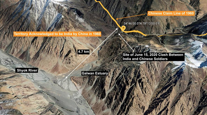 Satellite image of the Galwan Valley from its point of confluence with the Shyok up to the 1960 Chinese claim line. Source: Google Earth
For the Chinese side, the amnesia is understandable: Its official coordinates refute the claims it is making in Galwan today.
But one reason India has not referred to this crucial document is because the de facto boundary which emerges would place the areas where Indian and Chinese soldiers faced each other in a bloody standoff on June 15 – and where
satellite imagery suggests the Chinese are still present – squarely within what should be undisputed Indian territory. And this would contradict
Prime Minister Narendra Modi’s assurance to the country that China has “not intruded, is not intruding and is not in occupation of any Indian posts”, or territory.
The Line of Actual Control (LAC) in eastern Ladakh is essentially a creation of war. India claims all of Aksai Chin but was slowly pushed out of it in the 1950s. In the 1962 war, the PLA advanced all along eastern Ladakh and took control of the areas China had been claiming since 1960, barring a small area near Demchok.
We have quite a precise idea of what their claims were because of the special official level talks that took place through 1960. In the process of those discussions, the Chinese side provided detailed map coordinates to their Indian counterparts.
After the war, the Chinese claimed that they withdrew 20 kms behind even their claimed line, a posture they said they maintained till 1987. The Indian side had no choice but to live with the situation and accepted this Chinese claim line as the LAC. As the Indian official spokesman Anurag Srivastava
asserted on June 25 “Indian troops are fully familiar with the alignment of the LAC in all sectors of the India-China border areas and abide scrupulously by it.” In recent years, on one pretext or the other, however, the Chinese side has been seeking to expand their claim further into the Indian side of the LAC.
This becomes evident when you plot China’s claim line using the coordinates they provided at the official talks on Google Earth. And this is underscored by the recent
claims of the Chinese official spokesperson that the confluence of the Galwan and Shyok rivers is the where the LAC lies.
However, the 1960 map coordinates contained in the 1960
Report of the Officials of the Governments of India and the Peoples’ Republic of China on the Boundary Question tell a different story.
In the west,
according to the Chinese officials, from Karakoram Pass, the boundary runs eastward to a point east of 78°05’E , the line turned southwest to a point 78°1’E and 35° 21’N where it crossed the Chip Chap river. After this, it turned southeast along the mountain ridge and passed through two peaks 6845 metres (78°12 ‘ E and 34° 57’N) and Peak 6598 metres (78° 13’E 34° 54’N. Thereafter it crossed the Galwan River at 78°13’E 34° 46N. Thereafter it passes through peak 6,556 (approximately 78° 26′ E, 34° 32′ N), and runs along the watershed between the Kugrang Tsangpo River and its tributary the Changlung River to approximately 78° 53′ E, 34° 22′ N. where it crosses the Changlung River and reaches the Kongka Pass. It reached the Pangong Lake at 78° 49’E, 33° 44’N and crossed the southern bank of the Lake at 78° 43’E, 33° 40’N.
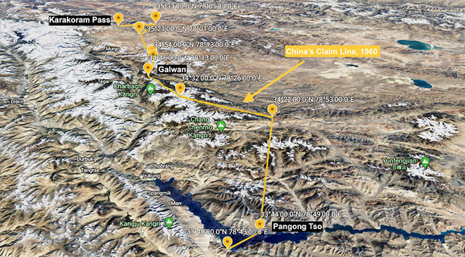 The Chinese claim line as presented to the Indian government in 1960, from the Karakoram Pass to Pangong Tso. Image: Google Earth
When the Chinese coordinates are plotted on Google Earth and one zooms in for greater detail in Galwan and Pangong Tso, it becomes clear that the Chinese are today trying to claim territory outside their official 1960 claim line, both at Galwan and Pangong Tso. Here, the LAC The line also makes it clear Modi was being economical with truth when he claimed that no Chinese were or are on the Indian side of the LAC.
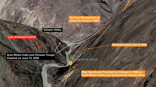 Close up satellite image of the Y-bend in the Galwan River, site of the recent clash between Indian and Chinese soldiers on June 15, 2020. The Line of Actual Control, shown in red, runs a little west of the Chinese claim line of 1960, shown in orange. But both lines show the area where the clash occurred, and the Galwan Valley as unambiguously on the Indian side. Image: Google Earth
In essence, China is occupying Indian territory between the yellow line and the areas where the June 15 clash took place. This is despite the prime minister’s claim that the Army had actually prevented Chinese troops from capturing Indian territory.
Current satellite imagery shows that the Chinese are almost 0.5 kms into the Indian side of the LAC and are digging down for a long stay.
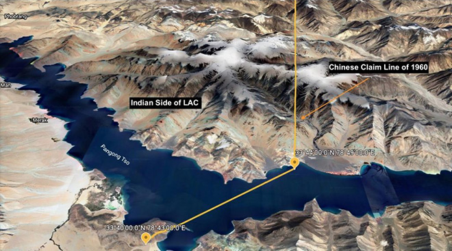 Close up satellite image of the Chinese claim line of 1960 at Pangong Tso. Image: Google Earth
In the Pangong Tso, plotting the coordinates given in 1960 on Google Earth reveals that the LAC should run through Finger 7 and Finger 8, as the Indian side says it does, not Finger 2 which the Chinese claim or Finger 4 where the Chinese have created a blockade to prevent India from patrolling up to where the LAC should run by China’s own reckoning. Again, the Chinese are clearly occupying Indian territory here, as they are in Galwan and Hot Springs, as satellite imagery in the public domain suggests:
https://twitter.com/detresfa_/status/1277227372610117632?s=20
It is easy to understand why the Chinese side have forgotten that they had provided India with the detailed longitude and latitude of the points they claimed constituted China’s boundary in Eastern Ladakh.
Just why India has ignored these coordinates is not clear. All said and done, they make for an iron-clad case for India in both Pangong Tso and Galwan, and, indeed, in the Depsang area as well.
The reason could well be the Prime Minister’s
somewhat ill-considered and enigmatic statement to the all party meeting on June 19, that “neither is anyone inside our territory nor is any of our post captured.” Modi has doubled down on his claim by repeating bravely again on June 28 in his Mann Ki Baat broadcast that “those who cast an evil eye on Indian soil in Ladakh have got a befitting response.“
The record, unfortunately shows, that that is simply not true. The Chinese are very much in occupation of Indian territory and show no signs of wanting to leave.
This commentary originally appeared in The Wire.
The views expressed above belong to the author(s). ORF research and analyses now available on Telegram! Click here to access our curated content — blogs, longforms and interviews.