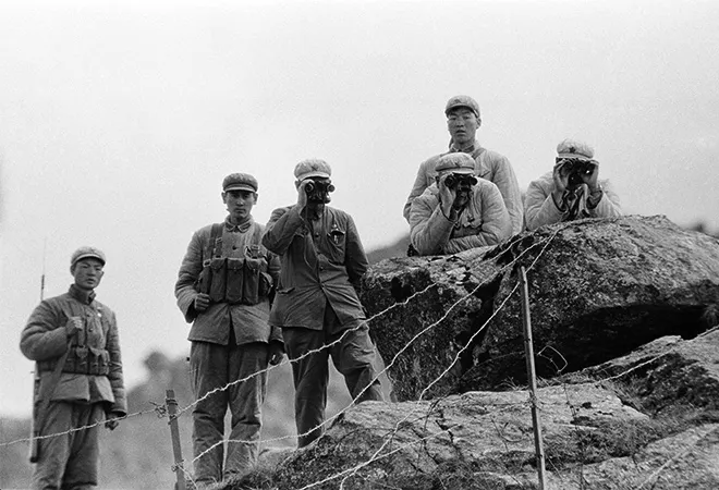
For more than 100 days, tensions have been high between India and China along their disputed Himalayan border. This tension has been most acute in eastern Ladakh, where, in mid-June, 20 Indian soldiers and an unspecified number of Chinese soldiers were killed in the Galwan Valley, the first fatalities along the de facto Line of Actual Control in 45 years. Even supposing a de-escalation will eventually occur — whether by diplomacy or by seasonal necessity — the likelihood of future cycles of conflict underscores the importance of examining the deeper roots of India and China’s missing border.
Central to today’s border dispute is a colonial legacy involving watersheds, “no-man’s lands,” and a surveyor named William Johnson. The Republic of India inherited substantial territorial baggage at independence. On top of the violence and upheaval of Partition, the integration of more than 550 princely states, and a war with Pakistan over Kashmir, the British Empire bequeathed to India official maps that were in many cases literally borderless. These maps were the result of a border-making principle centered on watershed limits that worked better in theory than in practice. While the British Empire could tolerate the ambiguity this problem produced, the newly independent Republic of India could not.
The science of border-making: The water-parting principle
The British failure to demarcate a borderline in the western Himalayas was not for lack of trying. From the moment the East India Company defeated the Sikh Empire in the First Anglo-Sikh War in 1846, the Company sent out boundary commissioners to survey its newly formed dependency, Jammu and Kashmir. This British-made princely state included Ladakh, conquered by the Raja of Jammu 12 years earlier. The boundary commissioners were given instructions to use the “water-partings”— the limits of the watersheds — to guide their delineation.
The British insistence on surveying and mapping a complete border reflected a different conception of territory, one that looked to geographical features to delineate political control on precise, official maps. This application of Westphalian notions of contiguous states was driven by advances in geography and surveying.
While Ladakh had long-established historical border points, the region’s principal historical source, The Ladakh Chronicles (La dwags rGyal rabs), reveals no complete borderlines encircling Ladakh. This omission reflected the practical reality of a region defined by passes and trade routes (the name Ladakh literally means “land of passes”). Points in eastern Ladakh, such as Demchok, or the Zoji Pass separating Ladakh from Kashmir, functioned as sufficient borders since they fell along well-established routes.
The British insistence on surveying and mapping a complete border reflected a different conception of territory, one that looked to geographical features to delineate political control on precise, official maps. This application of Westphalian notions of contiguous states was driven by advances in geography and surveying. It also implied a causal relation between geography and the state, one reflected in the term geopolitics — a term first coined in 1899, reflecting a worldview in which the strength or weakness of a natural border could determine the life or death of a state. In this logic, borders became the sine qua non of territory, necessary prerequisites for the survival of a state.
To accomplish this bordering of the globe, imperial experts formulated border-making principles. In mountainous regions they typically turned to watersheds, assuming their limits would yield precise, mappable lines unlikely to be disputed. When the 1846-8 boundary commissions arrived in eastern Ladakh, they set their sights on the upper reaches of the Indus River. The Indus River watershed would become, by the end of the century, the stated northern limit of India, despite the British failure to survey and demarcated much of it. The “water-parting principle” was by then being applied to boundary demarcation across the globe. It is one of the enduring ironies of the history of the India-China border that one of the first laboratories of modern border-making techniques failed to yield a border.
When the 1846-8 boundary commissions arrived in eastern Ladakh, they set their sights on the upper reaches of the Indus River. The Indus River watershed would become, by the end of the century, the stated northern limit of India, despite the British failure to survey and demarcated much of it.
The principal cause of this failure was the complex topography of eastern Ladakh and the western Tibetan Plateau. In this region there is no single mountain range to provide the guiding line for a would-be border. Ladakh and the broader western Himalayan region is part of a topographical tangle of mountains hundreds of miles wide. This complex of mountains and high, arid plateau is a far cry from the linear image of the Himalayas so often depicted on maps, or imagined, as Iqbal eloquently put it, as the “dīwār-i-Hindustān” (India’s wall).
The British would sporadically send small-scale surveying parties to Ladakh. But the cardinal points of concern for them lay along the region’s two main access routes: the Leh-Yarkand route to the north via the Karakoram Pass and the Leh-Lhasa route to the southeast via Demchok. The empty expanse of high plateau to the northeast remained a blank.
No-man’s land: The problem of the Aksai Chin
The Aksai Chin, although traversed for trade and pilgrimage, was never permanently inhabited, effectively a non-state space. Much of the mountainous terrain of eastern Ladakh and the western Tibetan Plateau is simply too harsh to support permanent settlement — a challenge Indian and Chinese soldiers today know all too well.
The limited influence of the Qing Empire in Tibet and the distance to China’s reclaimed territories in Xinjiang prompted Britain to “induce China to occupy” more of the “no-man’s land” beyond the Karakoram Pass.
Having settled on the Indus watershed as forming India’s northern border, the British recognised that a fully demarcated border in the sparsely populated region was not an immediate concern. Neither the Russian Empire nor the Qing Empire had directly encroached on the region. To the north and west, boundary commissions would establish the boundaries of Afghanistan, creating a buffer between the British and Russian Empires. Here, too, the “water-parting principle” was employed, forming the Durand Line now constituting the border between Pakistan and Afghanistan — a porous boundary that was not accepted by the Afghans and remains a “defiant border” today.
The limited influence of the Qing Empire in Tibet and the distance to China’s reclaimed territories in Xinjiang prompted Britain to “induce China to occupy” more of the “no-man’s land” beyond the Karakoram Pass. It was only when fears grew of Russian influence in Tibet that the British marched on Lhasa in 1903–4, forcibly establishing diplomatic relations. At the Shimla Conference a decade later, the British attempted to configure Tibet as a buffer state, keeping at a safe distance their two rival empires in Central Asia.
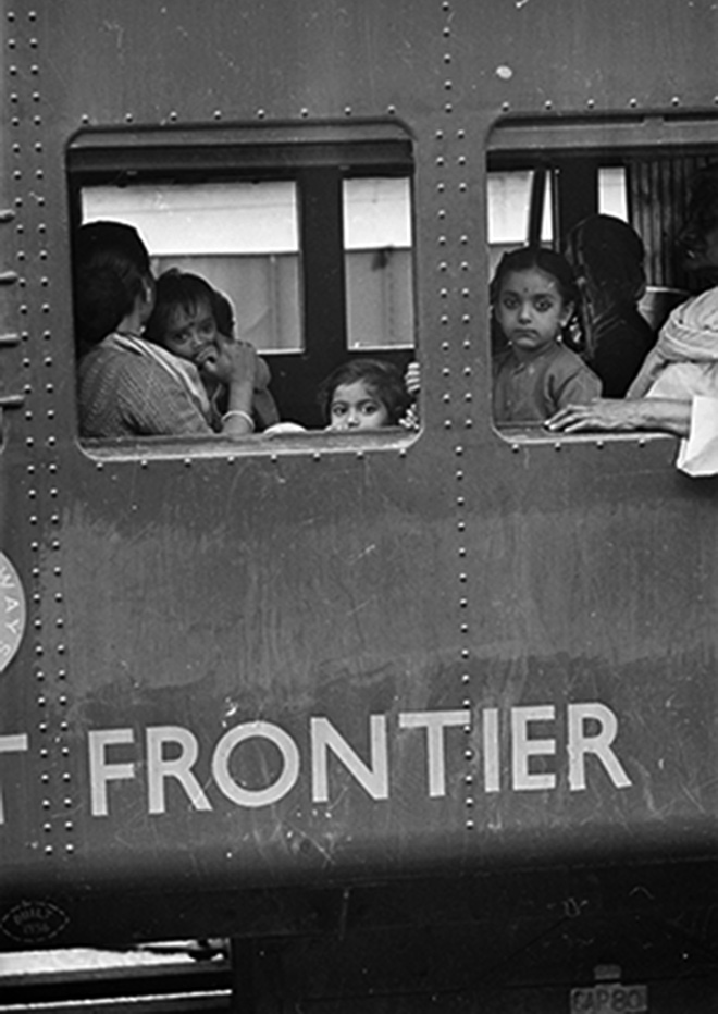 Refugees arriving by train at Tezpur during border clashes with China — 22 November 1962. © Terry Fincher/Express/Getty
When Henry McMahon, the British representative at the trilateral Shimla Conference, insisted on a watershed limit for the proposed boundary between “Outer Tibet” and India, the water-parting principle was also applied to the topography of the eastern Himalayas. But even in the case of the line that now bears McMahon’s name, limited survey data and complex topography produced discrepancies between the line on the treaty map and the actual watershed. And like Ladakh, Tibet’s historical territory was not precisely mappable, nor was its political relationship with China clear.
The Johnson and Macartney-MacDonald lines
The map that resulted from the first Ladakh boundary commissions in 1846-8 did not instill much confidence. The first map to represent a northern and eastern border came from a survey in 1865, carried out by William Johnson, who would later become the maharaja’s appointed wazīr-i-wazārat in Ladakh.
As it turned out, not only does the Indus watershed limit not coincide with the ring of mountains that formed his proposed eastern border, but subsequent surveys and satellite images revealed that much of his sketched ring of mountains did not even exist.
Unlike the more precise trigonometric surveys carried out across much of the subcontinent by the Survey of India, Johnson made a single north-south “traverse survey” of the Aksai Chin. The resulting map, published in 1867, formed the first instance of the shape of the Aksai Chin that subsequent maps would depict. Johnson, however, did not identify water-partings, nor did he do more than sketch a perimeter of mountains. As it turned out, not only does the Indus watershed limit not coincide with the ring of mountains that formed his proposed eastern border, but subsequent surveys and satellite images revealed that much of his sketched ring of mountains did not even exist.
While some subsequent maps would utilise the general shape of Johnson’s map, others showed no border at all. In 1893, a map was shown to the British consul at Kashgar that depicted China’s vague claim to Xinjiang. The map suggested that the Qing government considered the Aksai Chin to be a part of India. The British saw an opportunity to extend the recently completed Durand Line around Ladakh.
The result was the Macartney-MacDonald Line, named after the British consul at Kashgar and Britain’s minister to China. MacDonald described the line in a 14 March 1899 letter to Beijing. It stretched from the Pamirs, across the Karakoram Pass, and down a “crest of mountains” to eastern Ladakh. But he also noted that “it will not be necessary to mark out the frontier. The natural frontier is the crest of a range of mighty mountains, a great part of which is quite inaccessible.” This vagueness had been revealed a few months earlier when the viceroy had written to his superior in London that he regretted “that we have no map to show the whole line either accurately or on a large scale.” In any case, the Chinese never responded.
India’s troubled inheritance
Maps continued to play a central role following India’s independence. The borderless maps inherited by India were revised in the 1950s without mutual demarcation and assuming the general shape of the Johnson Line. As in China, maps in India that failed to depict claimed territory were prohibited. This only intensified after the war with China in 1962. Subsequent bilateral agreements have failed to address the situation beyond insisting on maintenance of a vague status quo along a line that in practice has functioned more like a frontier: contested, imprecise, and liable to move.
If the violence of this summer and the tragic loss of life in the Galwan Valley are to have any lessons, it is that the topography of eastern Ladakh and the Aksai Chin does not make possible the application of a simple border-demarcation principle.
The views expressed above belong to the author(s). ORF research and analyses now available on Telegram! Click here to access our curated content — blogs, longforms and interviews.