The China-India hydropolitics over the Yarlung Tsangpo/Brahmaputra has generally been perceived as “hydro-hegemon” China’s ill intent towards downstream India’s interests. Earlier, a host of contentions were floated in the media about China’s gravity dam project, the Zangmu Dam on the Yarlung Tsangpo/Brahmaputra system on the northwest of Gyaca in the Tibet Autonomous Region (TAR) of China. As such, many such incidents over the Brahmaputra in the Indian boundary have been attributed to China’s evil designs against India, examples of which include the increase in turbidity and blackening of waters in Tsiang (the name of Yarlung Tsangpo in Arunachal Pradesh), temporary stoppage of data sharing by China over the high season flows as per the China-India MoU during the Doklam standoff, and news of a series of check dams being constructed along the Tibetan boundary.
Over the last 48 hours, global and Indian media are replete with the news of Chinese plans to build a “super” dam on the lower reaches of the Yarlung Tsangpo close to the Line of Actual Control (LAC) in Tibet. Certain news reports state that this move can “… have a far-reaching impact on northeast India’s water security.” The dam is reported to have been proposed in the Medog county of TAR, close to Arunachal Pradesh. The gravity of this intervention and its impact on downstream India need to be understood from the perspective of existing hydrological flow and precipitation regimes.
Both the hydrology and precipitation over the Yarlung Tsangpo/Brahmaputra are highly correlated.
At the very outset, one needs to note that both the hydrology and precipitation over the Yarlung Tsangpo/Brahmaputra are highly correlated, despite the fact that the system is fed by rainfall, as well as snow and glacial melts. The contribution of snow and glacial melt to the flow is substantially low in the overall stretch; however, its contribution is higher in the upper reaches of the flow which are in the rain-shadow region. Of the total 2,880 kilometres (kms) length of the Yarlung Tsangpo/ Brahmaputra, 1,625 kms flows through the Tibetan plateau with the name Yarlung Tsangpo, whereas it assumes the names of Siang, Dihang, and Brahmaputra in its 918 kilometres in India, and the rest of the 337 kilometres in Bangladesh is named the Jamuna till its confluence with the Ganges near Goalando. Though this geographical distribution of length gives an apparent impression that the maximum flow of the system occurs in the TAR of China, it is a myth! Rather, the system becomes stronger and fatter as it flows further downstream. It needs to be noted here that the Brahmaputra is identified as the flow downstream of the confluence of three tributaries, namely the Luhit, Dibang, and Dihang, near Sadiya in the Indian state of Assam.
A huge variability is noted in the precipitation and run-offs. A large part of the Tibetan component of the basin, i.e. the longer stretch of the Yarlung, is located in the rain-shadow north aspect of the Himalaya, and is therefore a recipient of much less rainfall as compared to the south aspect. Therefore, while the average annual precipitation in the trans-Himalaya is around 300 mm, the average annual precipitation (that includes mainly rainfall) reaches about 3,000 mm in the south aspect just after crossing the crestline. The foothills are frequently fed by anomalous precipitation of a magnitude that is capable of causing great floods. Within the Brahmaputra valley in Assam, the average annual rainfall is higher in the northeastern areas and gradually decreases towards the western parts. In the peak flow periods, the Brahmaputra is fed by the monsoon rainfall.
A large part of the Tibetan component of the basin is located in the rain-shadow north aspect of the Himalaya, and is therefore a recipient of much less rainfall as compared to the south aspect.
Figure 1: Isohyet map showing distribution of precipitation in the Yarlung Tsangpo / Brahmaputra basin at the Great Bend and adjacent areas.
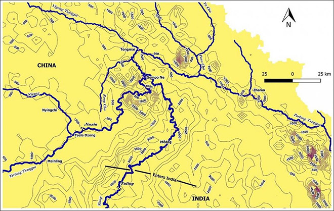 Source: Ghosh et al 2019
While the peak flows at Nuxia and Tsela Dzong — measuring stations at the great bend in the Tibetan plateau — are about 5,000 and 10,000 cubic metres per second (cumecs), the peak flow at Guwahati in Assam is approximately 55,000 cumecs. The lean season flow in Nuxia is in the range of 300-500 cumecs, while the lean flow at Pasighat in India is to the tune of 2,000-plus cumecs, the one at Guwahati is around 4000-plus cumecs, and at Bahadurabad it is about 5,000 cumecs. Summarily, one may state that the annual discharge of 31.2 billion cubic metres (BCM) at Nuxia simply does not compare with annual discharges of Pandu/Guwahati (494 BCM) or that of Bahadurabad in Bangladesh (625 BCM). At the same time, the sediment regime also follows the same pattern, with the run-off in the rain-shadow region not being sufficient to carry the massive sediment load recorded downstream. The Brahamputra’s large mainstream flows of water and sediments are contributed by many of its large tributaries including Dibang, Dihang (Siang), Luhit, Subansiri, Manas, Sankosh, Teesta, etc. While Nuxia records an annual suspended sediment load of around 30 million metric tonnes, (as suggested in a 2016 volume titled River Morphodynamics and Stream Ecology of the Qinghai-Tibet Plateau by Wang and colleagues), the same is recorded at 735 million metric tonnes in Bahadurabad.
One more thing needs to be kept in mind. The potentially utilisable water resources or PUWR of the Brahmaputra is barely 25 per cent in terms of data from the erstwhile Ministry of Water Resources (presently MoJS). Therefore, given the precipitation, run-off and sediment flow regimes, it is unlikely that any intervention on the Yarlung Tsangpo in the north aspect of the Himalaya can cause any substantial harm for downstream economies including India and Bangladesh, irrespective of Chinese intent. This is largely true given the location of the Zangmu hydropower project.
Given the precipitation, run-off and sediment flow regimes, it is unlikely that any intervention on the Yarlung Tsangpo in the north aspect of the Himalaya can cause any substantial harm for downstream economies.
However, the same cannot be stated for the present proposed project in the Medog county of TAR. This is because, the Medog county in TAR lies in the south aspect of the Himalayas, where the flow of the mainstream Yarlung is enhanced by the flow of another tributary Parlung Tsangpo as shown in Fig. 1. The isohyet in Fig. 1 in Medog shows an annual average precipitation of 3,000 mm, substantially higher than the 500 mm recorded at Nuxia. Moreover, there is some dispute with the annual discharge data of the Yarlung at the point of leaving China. While estimates by some Chinese scholars state that the discharge is of the tune of 135.9 BCM, the ministry data suggests the same to be 78.1 BCM. The percentage divergence between the two data sets is quite big. However, some older estimates in India suggest that the discharge in Tuting in Arunachal Pradesh is 179 BCM. Therefore, in percentage terms, the contribution emerging from the Chinese boundary to the immediate point in the Indian boundary cannot be stated to be negligible, though this turns out to be of not much significance to the run-offs in the Assam floodplains in India or the Jamuna floodplains in Bangladesh.
The concern is now two-fold. China, ideally, should be opting for a run-of-the-river project, which may not alter the annual flow regime, but can have deleterious ecosystem impacts in the Tibetan boundary with probable spin-offs in Arunachal Pradesh. But, what one cannot be sure of is that during lean season whether the flow will be substantial for a run-of-the-river project to operate. Therefore, if there is impounding of the flow through some storage mechanisms, there will be some impacts on Arunachal Pradesh’s water availability though the impact may not be felt further downstream after Sadiya. However, the second probable impact is of greater concern. This is because our own research suggests that the region, entailing the Great Bend at the intersection of the basins of Yigong Tsangpo, Parlung Tsangpo, and the Lower Yarlung, exhibit events like high monsoonal precipitation, strong possibilities of landslides and avalanches leading to flash floods, with the average annual frequency of such hazardous events being 10 or more. Further even, Medog witnesses 12-15 such incidents on an average. The biggest concern of the space is its unpredictable tectonicity as is prevalent in large parts of Eastern Himalayan system. Therefore, any such event resulting in any form of dam burst or otherwise can have deleterious impacts on the immediate downstream particularly Arunachal Pradesh which will most likely experience sudden flooding.
The dam in Medog can have negative impacts on Arunachal Pradesh.
Of course, this present commentary is facing the limitations that come from lack of data that could have enabled a better analysis; rather, data had to be collated from various sources to arrive at certain conclusions. But given what we have presently, it can be summarised that the dam in Medog can have negative impacts on Arunachal Pradesh, but there does not seem to be any impact on Assam and Bangladesh. Hence, the contention of the dam having “…far-reaching impact on northeast India’s water security” seems exaggerated. Yet, there is an utmost need for de-classifying the transboundary flow data by the Government of India to enable independent objective analysis for better informed hydrodiplomacy. Misinformation is causing more harm!
The views expressed above belong to the author(s). ORF research and analyses now available on Telegram! Click here to access our curated content — blogs, longforms and interviews.